You’ll find exceptional drone photography at West Virginia’s most atmospheric ghost towns: Thurmond’s restored rail depot, Kaymoor’s 800-foot vertical mining ruins, and Nuttallburg’s impressive coal complex. Launch your drone at sunrise to capture golden light on weathered industrial remnants, or frame reflective creek views against abandoned structures. Mount Wood Castle and Winona offer unique perspectives where nature reclaims history. Let’s explore these haunting locations and their compelling visual stories.
Key Takeaways
- Thurmond offers exceptional drone photography with its preserved 1904 rail depot, abandoned yards, and strategic position along New River Gorge.
- Kaymoor Mining Ruins provide dramatic aerial opportunities with its 800-foot vertical layout and historic industrial structures against natural backdrops.
- Nuttallburg’s coal complex features a 1,385-foot conveyor system and geometric industrial architecture perfect for dramatic aerial compositions.
- Winona combines abandoned coal-era structures with Keeney’s Creek Baptist Church, offering compelling visual narratives from above.
- Mount Wood Castle presents unique drone photography potential with its concrete ruins and panoramic views of the Ohio River Valley.
Exploring Thurmond’s Historic Rail Depot Through the Lens
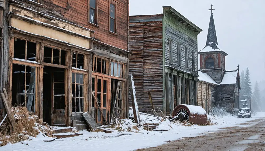
Perched along the New River Gorge, Thurmond’s historic rail depot stands as a photographer’s dream, offering unique aerial perspectives of America’s industrial past. Your drone can capture the striking contrast between the restored 1904 depot architecture and the wild landscape that surrounds it.
The two-story wooden structure, with its distinctive slate roof and signal tower bay, tells a compelling story of rail history through your lens. You’ll want to position your drone to showcase how the tracks hug the riverside, with the depot’s linear design creating leading lines in your composition. During its peak in 1910, the bustling station processed an impressive 75,000 passengers annually.
The coaling tower and abandoned rail yards nearby add depth to your industrial narrative, while the untouched ghost town setting lets you document a slice of Appalachian heritage that once processed more freight than Cincinnati and Richmond combined. The National Park Service now maintains most of the town, preserving its authentic historical character for future generations.
As you explore the area, be sure to take in the scenic night skies in West Virginia, a breathtaking backdrop that complements the rich history of the location. The stars twinkle brightly above, providing a stunning contrast to the remnants of the past scattered throughout the landscape. This unique combination of natural beauty and historical significance makes for an unforgettable experience that captures the essence of Appalachian culture.
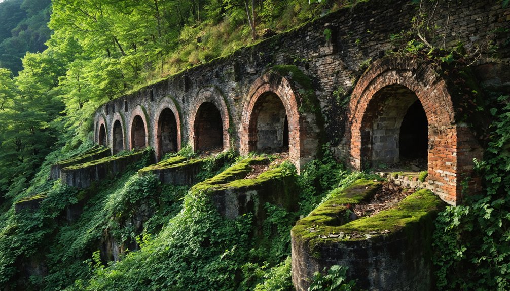
Kaymoor Mining Ruins: Capturing Industrial Heritage From Above
You’ll want to position your drone at sunrise to capture dramatic shadows cast by Kaymoor’s towering headhouse and conveyor ruins against the steep New River Gorge walls.
The site’s 800-foot vertical layout presents unique flight planning challenges around the historic stairs and industrial remnants, requiring careful altitude management and obstacle awareness. Experienced pilots should note that Kaymoor Two mine, situated near Fayette Station Road, was filled with concrete during the New River Gorge Bridge construction. An old safety board still stands at the entrance, a somber reminder of past mining fatalities.
Your aerial compositions can emphasize the stark contrast between nature’s reclamation and the geometric forms of collapsed tipples, coke ovens, and scattered mining equipment that once processed over 16 million tons of coal.
Dramatic Vertical Mining Elements
Kaymoor’s most distinctive feature is the 1,000-foot steep incline that transported workers between the upper and lower mining camps. During its peak years, the site employed 1,500 miners who relied on this dramatic vertical transportation system daily.
Sunrise Over Industrial Ruins
Among the most enchanting moments for drone photographers at Kaymoor Mining Ruins comes during sunrise, when golden light first strikes the weathered industrial remnants.
The 16.9 million tons of coal extracted from these mines left behind compelling structural remnants that create striking aerial compositions.
Originally established by Low Moor Coal in 1900, these historic ruins stand as silent witnesses to West Virginia’s industrial heritage.
Today, many of these ghost towns in West Virginia serve as intriguing destinations for adventurous explorers and history enthusiasts alike. Visitors can wander through the remnants of old buildings and mines, gaining insight into the lives of those who once thrived in these communities. The stories etched in the walls of these abandoned places reflect a bygone era, captivating the imagination of all who venture there.
Explorers can also discover ghost towns near West Virginia trails, where nature has begun to reclaim its territory, enveloping structures in lush greenery. These trails offer a unique opportunity to experience both the beauty of the landscape and the haunting remnants of history, creating a fascinating juxtaposition. Each hike reveals hidden stories waiting to be uncovered, making every visit an adventure filled with discovery.
You’ll find dramatic industrial textures as the low-angle light emphasizes corroded metal and masonry details, while sunrise silhouettes transform the remaining structures into graphic compositions against the brightening sky.
- Position your drone along the gorge rim to capture the interplay between Kaymoor Top and Bottom, where morning fog often creates mystical separation between the two historic levels.
- Utilize HDR bracketing to balance the intense sunrise backlight with shadowed ruins.
- Time your flights for seasonal river mists that isolate structures and add atmospheric depth to your compositions.
For best results, scout your launch sites in advance and secure any needed NPS permissions for these powerful dawn shoots.
Flight Planning Around Stairs
Three critical challenges confront drone photographers at Kaymoor’s historic stairway: launch site selection, gear transport, and flight path optimization.
Don’t attempt launches from the narrow 800-step staircase – instead, choose flat clearings at the canyon rim or trailhead parking areas where you’ll have 10-20 meters of obstruction-free space. The descent passes by numerous mine openings visible along the trail, offering unique aerial photography opportunities.
For drone safety, scout multiple emergency landing zones before descending, as the steep terrain offers few viable options near the stairs. With access to commercial stock photos, you can study the terrain and plan landing zones before your visit.
Pack your gear efficiently using a backpack with waist support to manage the demanding climb. You’ll want to minimize stair trips, so plan your battery count carefully.
Consider bypassing the stairs entirely by launching from authorized rim road access points – just secure proper permissions first and maintain safe distances from historic structures.
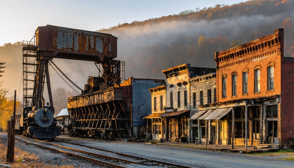
Aerial Adventures at Nuttallburg’s Preserved Coal Complex
Standing as a tribute to West Virginia’s industrial heritage, Nuttallburg’s preserved coal complex offers drone photographers an exceptional canvas of geometric industrial architecture against the dramatic backdrop of the New River Gorge.
Rusting remnants of America’s industrial past, Nuttallburg stands sentinel over the New River Gorge, its geometric silhouette etched against wild Appalachian beauty.
For ideal aerial shots that capture Nuttallburg’s significance, consider these prime vantage points:
- Frame the Ford-era tipple’s silhouette during golden hour, using its stark industrial geometry as leading lines against the gorge’s natural contours.
- Follow the 1,385-foot “rope-and-button” conveyor system with your drone, creating dramatic perspective shots that showcase the scale of historic coal operations.
- Capture the rhythmic patterns of coke oven ruins and former house foundations from above, revealing the ghost town’s layout through texture and shadow play.
Remember to secure necessary NPS permits before flight, as this federally protected site requires special authorization for drone operations.
Discovering Sewell’s Hidden Coke Ovens by Drone
While Nuttallburg showcases preserved industrial architecture, Sewell’s hidden coke ovens present drone photographers with a unique challenge of capturing America’s largest historical coking operation beneath dense forest cover.
You’ll find nearly 200 beehive-style Sewell ovens scattered along the railroad line near Cunard’s rafting access point. For ideal drone exploration, launch from the flat riverbank areas to capture aerial views of these industrial remnants.
Your footage can document both the massive scale of this operation – which ran until 1956 – and surviving structures like the stone railway engine house.
Focus your lens on the sprawling layout of coke ovens, conveyor systems, and larry car remains. The site’s proximity to rafting areas provides convenient launch zones, letting you frame dramatic shots of this once-bustling coking complex against the New River Gorge landscape.
Winona: Where Past Meets Present in Aerial Photography
You’ll find Winona’s blend of active worship at Keeney’s Creek Baptist Church alongside abandoned structures creates compelling visual narratives when framed against the valley’s forested backdrop.
Your drone’s ability to capture reflections in Keeneys Creek adds mirror-like qualities to shots that connect past and present, especially during golden hour when water surfaces gleam.
Position your aircraft to layer historic foundations in the foreground while catching the creek’s serpentine path through dense foliage, creating depth that emphasizes both preservation and nature’s reclamation.
Mixing History With Life
As you soar above the highlands north of New River Gorge, Winona presents a compelling mix of historical remnants and modern life through your drone’s lens. The interplay between past and present creates dynamic compositions that tell the story of this coal-mining community’s cultural significance.
- Frame your shots with Keeneys Creek Baptist Church in the foreground, capturing both its historical context as Carter G. Woodson’s legacy site and its continued role in today’s community.
- Position your drone to contrast inhabited modern structures against the weathered coal-era buildings.
- Utilize golden hour lighting to emphasize the transformation where former segregated mining quarters blend into the natural landscape.
Your aerial perspective reveals how Winona’s industrial heritage persists alongside contemporary life, offering unique opportunities to document this evolving narrative through thoughtful drone photography.
Capturing Reflective Creek Views
The crystalline waters of Gauley River create stunning mirror-like reflections that transform Winona’s historic ruins into doubled works of art through your drone’s lens.
Launch your DJI Phantom from Route 60’s strategic pull-offs to capture reflective symmetry at 400 feet, where creek bends amplify the visual impact of your aerial compositions.
You’ll find ideal conditions during golden hour when east-facing creeks maximize reflection vibrancy.
For technical perfection, mount ND filters to reduce midday glare on water surfaces.
Frame your shots with the abandoned high school ruins and coal tipple remnants creating stark foregrounds against glass-like pools.
The surrounding forested hills add depth with seasonal color, while railroad tracks introduce compelling linear patterns.
Just remember to maintain FAA Part 107 compliance and avoid restricted New River Gorge airspace.
Mount Wood Castle: Urban Ruins With a Skyline View
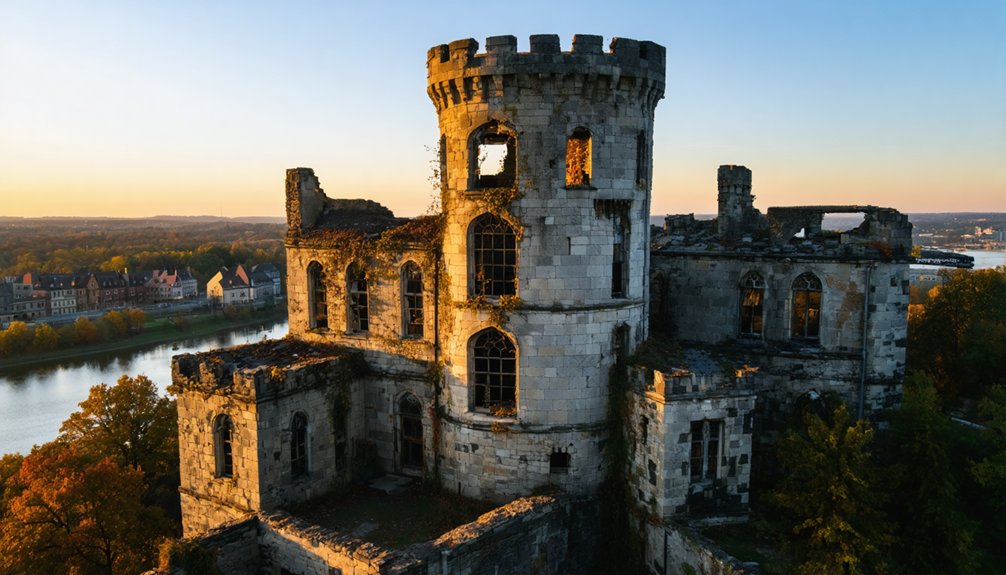
Standing sentinel above Wheeling’s skyline, Mount Wood Castle‘s unfinished concrete ruins offer drone photographers a compelling mix of urban decay and panoramic vistas.
This abandoned 1920s structure, with its distinctive turrets and multi-level design, provides perfect compositions for urban exploration enthusiasts wielding aerial cameras.
- Position your drone at golden hour to capture dramatic shadows cast by the castle’s concrete skeleton against the Ohio River Valley backdrop.
- Frame shots through the freestanding arch to create depth, incorporating both the graffiti-covered walls and the historic Mt. Wood Cemetery.
- Utilize altitude variations to contrast the castle’s crumbling turrets against Wheeling Creek’s winding path below.
The site’s elevated position and unobstructed views make it ideal for cinematic reveals and establishing shots, while its textured surfaces create compelling abstract patterns from above.
Frequently Asked Questions
Are There Specific Seasons When Ghost Town Drone Photography Is Most Dramatic?
You’ll capture the most dramatic shots in fall and winter when seasonal lighting intensifies decay and atmospheric conditions are clearest – especially during golden hour with stark shadows and vibrant contrasts.
What Backup Gear Should I Pack for Remote Ghost Town Shoots?
Like a well-oiled machine, you’ll need extra batteries, multiple camera lenses, backup SD cards, lens cleaners, and propeller sets. Don’t forget your power bank and portable charger for long shoots.
How Do You Handle Unexpected Wildlife Encounters During Drone Flights?
Immediately land your drone if you spot wildlife, maintaining legal distances. Watch for stress behaviors and avoid hovering. Keep your controller ready for quick altitude changes or emergency landing protocols.
Which Drone Filters Work Best for Capturing Weathered Building Textures?
You’ll want ND8 filters for golden hour shots and polarizer filters for midday flights. Combining ND/PL filters will cut glare while revealing subtle textures in deteriorating wood and rusty metal.
Can I Sell Ghost Town Drone Footage to Historical Preservation Organizations?
You can monetize your footage through licensing agreements with preservation groups – document historical significance, maintain quality standards, and directly negotiate usage rights while retaining creative control of your aerial work.
References
- https://thedronelifenj.com/best-places-to-fly-a-drone-in-west-virginia/
- https://www.youtube.com/watch?v=oSAbw3ip8Pg
- https://www.onlyinyourstate.com/experiences/west-virginia/wheeling-castle-drone-wv
- https://wvtourism.com/5-wv-ghost-towns/
- https://www.youtube.com/watch?v=-EeLwLa2t90
- https://ynstmagazine.com/perspective/documenting-the-almost-ghost-town-of-thurmond-wv/
- https://www.youtube.com/watch?v=Z_9T_Ea5T7I
- https://www.youtube.com/watch?v=J2ZE7gr43sA
- https://hawkinsrails.net/preservation/thurmond/thurmond.htm
- https://www.nps.gov/places/thurmond-historic-district.htm