You’ll discover Massachusetts’ most intriguing ghost towns scattered across the state’s diverse landscape. Dogtown’s stone foundations near Gloucester offer tales of witchcraft and colonial life, while Dana’s remnants lie beneath Quabbin Reservoir’s waters. The maritime ruins of Whitewash Village on Monomoy Island tell stories of shipwrecks and storms, and Haywardville’s industrial ruins showcase early American innovation. From coastal settlements to mill towns, each abandoned community holds centuries of fascinating historical secrets waiting to be uncovered.
Key Takeaways
- Dogtown, between Gloucester and Rockport, features haunting stone foundations and cellar holes from an 1800s settlement known for witchcraft legends.
- Dana’s preserved Common area above Quabbin Reservoir showcases remnants of a once-thriving town forced to relocate 2,000 residents in 1938.
- Whitewash Village on Monomoy Island was a bustling maritime community until an 1860 hurricane sealed its harbor, leading to abandonment.
- Haywardville’s Victorian-era mill ruins showcase industrial history, including sites where Goodyear and Hayward pioneered rubber vulcanization.
- West Boylston’s Old Stone Church, listed on the National Register, stands as the sole survivor of a town submerged by Wachusett Reservoir.
Exploring the Haunting Ruins of Dogtown
Nestled in the highlands between Gloucester and Rockport, the haunting ruins of Dogtown stand as a tribute to one of Massachusetts’ most intriguing ghost towns.
You’ll discover a settlement that thrived from 1693 until its gradual abandonment in the early 1800s, where only cellar holes and stone foundations remain of the once-prosperous community.
As you explore the abandoned structures, you’ll encounter remnants of a fascinating history marked by Dogtown legends of witchcraft and vagrants.
Originally settled by about 80 pioneer families seeking refuge from coastal raids, this inland location provided safety from pirates and Native American attacks.
The area earned its name from either the wild dogs left behind by departing residents or the protective canines kept by remaining widows.
Today, you can wander among Roger Babson’s Depression-era inspirational boulder carvings and trace the paths where colonists once walked, immersing yourself in the eerie solitude of this historic wilderness. Visitors should exercise caution when exploring the treacherous terrain, as many old foundations are at risk of collapse.
Dana: The Town Beneath Quabbin’s Waters
When the Massachusetts legislature sought to address Boston’s growing water crisis in the early 1900s, the town of Dana became one of four Swift River Valley communities sacrificed to create the massive Quabbin Reservoir.
You can still visit Dana Common today, preserved above the waterline as a haunting reminder of the town’s history. The site contains stone foundations and walls that mark where buildings once stood.
Before its decline, Dana thrived as a community of 695 residents in 1890.
Key aspects of Dana’s sacrifice for Boston’s water supply:
The flooding of Dana meant uprooting entire families and demolishing a community to quench Boston’s growing thirst for water.
- Dana officially ceased to exist at midnight on April 27, 1938
- The town held its final meeting in March 1938, with the school’s last graduation that June
- Over 2,000 residents were forced to abandon their homes and relocate
- Workers systematically destroyed buildings and cleared the land before flooding
- Parts of Dana were annexed to surrounding towns of Hardwick, New Salem, Petersham, and Ware
Whitewash Village: A Lost Maritime Community
Along the treacherous waters between Nantucket Sound and the Atlantic Ocean, Whitewash Village emerged as a resilient maritime community on Monomoy Island in the early 19th century.
At its peak, you’d find 200 hardy souls making their living from the sea, with fishermen hauling in cod and mackerel while wreckers salvaged bounty from ill-fated ships.
The village’s maritime heritage centered around Powder Hole harbor, where the Monomoy Point Lighthouse guided vessels through dangerous shoals. The 40-foot cast-iron tower was rebuilt in 1849 to better serve the growing community. The treacherous waters earned the area the nickname Cape of Evil Bars due to its deadly shoals.
You can imagine the bustling scenes at the Monomoit House tavern and the schoolhouse filled with children’s voices.
But nature had other plans – an 1860 hurricane sealed the harbor with sand, triggering a gradual coastal abandonment.
The Industrial Remnants of Haywardville
You’ll discover the fascinating ruins of Haywardville’s Victorian-era mills along Spot Pond Brook, where water-powered operations thrived for nearly three centuries before their late 19th-century abandonment.
The site’s industrial heritage spans multiple scales of manufacturing, from local gristmills to nationally-significant shoe production facilities that once formed the economic heart of Stoneham. Nathaniel Hayward and Charles Goodyear pioneered vulcanization of rubber here, revolutionizing the production of boots and other waterproof goods. Architectural historian Ryan D. Hayward leads visitors through the historic remnants, offering detailed insights into the village’s rich past.
Today, you can explore these preserved remnants deep in the Massachusetts woods, where the forgotten industrial village earned recognition in the National Register of Historic Places for its significance in early American manufacturing history.
Mill Operations and Decline
During the early 1800s, the industrial landscape of Haywardville transformed dramatically as Nathaniel Hayward established what would become the area’s largest and most influential rubber works operation.
This hub of industrial innovation flourished alongside silk mills, gristmills, and sawmills, creating a diverse manufacturing center that linked to regional and national trade networks.
Historians Ryan D. Hayward and Morris conducted extensive archival research to uncover the rich history of this vanished mill village.
You’ll find evidence of this once-thriving community through:
- Converted shoe mills along Spot Pond Brook that pioneered rubber production
- Silk processing facilities originally built for James Barrett
- Water-powered operations that ran for three centuries
- Mills that produced spices, chocolate, and tobacco
- Remnants preserved within today’s Middlesex Fells Reservation
The decline of these mills by the late 19th century led to mill preservation efforts, culminating in the Industrial Eden program’s documentation of this remarkable industrial heritage.
The site’s restoration and the relocation of buildings helped maintain the picturesque character of the area.
Water-Powered Industrial Heritage
The historic water-powered legacy of Haywardville remains etched into the landscape of Spot Pond Brook, where multiple mills once harnessed the modest stream’s flow through an intricate network of dams and raceways.
You’ll discover a rich industrial heritage spanning three centuries, where at least four mills operated simultaneously, producing everything from textiles to rubber products.
As you explore Virginia Wood’s interpretive trail today, you’ll find remnants of this innovative water power system that supported diverse industries from gristmills to textile manufacturing.
The site’s ingenuity is evident in its 1880s fire prevention infrastructure, later repurposed for mill operations.
Thanks to the Industrial Eden program’s preservation efforts, you can now trace this hidden history through the dense hemlock grove, where Spot Pond Brook’s waters once drove New England’s industrial revolution.
Preserved Victorian Mill Ruins
Hidden beneath Virginia Wood’s dense foliage, Haywardville’s preserved Victorian mill ruins stand as silent witnesses to Massachusetts’ industrial revolution.
You’ll discover the remnants of a once-thriving industrial heritage along Spot Pond Brook, where the “Red Mills” pioneered rubber manufacturing innovations from 1850 to 1870.
Thanks to preservation efforts by The Preservation Collaborative‘s “Industrial Eden” program, you can now explore:
- The original foundations of Nathaniel Hayward’s rubber works, where he and Goodyear invented slickers
- Remaining stone walls from multiple water-powered mills that drove the local economy
- Architectural traces of the Converse factory that Hayward transformed
- Historic waterway engineering that powered this industrial complex
- Structural evidence of the sawmill and gristmill that launched Haywardville’s industrial era
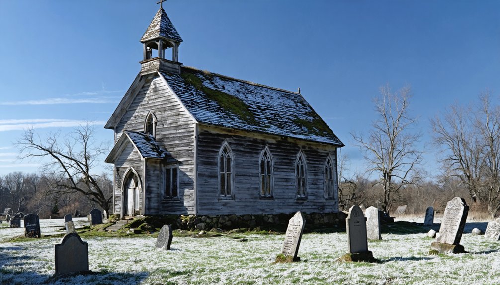
West Boylston’s Old Stone Church: A Solitary Sentinel
Standing sentinel above the Wachusett Reservoir, West Boylston’s Old Stone Church represents a poignant chapter in Massachusetts history, where progress clashed with community preservation.
Built in 1891 after a devastating fire destroyed its predecessor, this resilient stone structure survived while its surrounding town succumbed to the reservoir’s waters in 1905.
You’ll find this historic landmark at 130 Beaman Street, where it earned National Register status in 1973. Despite a near-fatal collapse in 1974, church preservation efforts restored this cultural icon by 1977.
Today, you can walk the grounds of this enduring symbol, though its stripped interior remains off-limits.
While the reservoir claimed over 2,200 acres and displaced 1,700 residents, the Old Stone Church stands as the sole witness to West Boylston’s submerged past.
Uncovering the Mysteries of Catamount

Among Massachusetts’ forgotten settlements, Catamount’s story emerges as a tribute to early American resilience and symbolism.
You’ll find this mountain village’s rich history embodied in its iconic 1812 schoolhouse, which became the first in America to fly the national flag – a powerful emblem of the community’s patriotic spirit.
- Settlement began in 1735, witnessing both the American Revolution and Shay’s Rebellion
- The village thrived as a farming community until its early 20th century decline
- 1812 marked the historic flag-raising that defined Catamount’s lasting legacy
- Now protected within the 1,125-acre Catamount State Forest since 1966
- Stone foundations and cellar holes remain as silent witnesses to village life
Today, you can explore these remnants on foot, tracing the paths where determined settlers once carved out their American dream.
Planning Your Ghost Town Adventure in Massachusetts
Whether you’re drawn to coastal ruins or submerged settlements, Massachusetts offers an extensive network of ghost towns that paint a vivid picture of the state’s evolution.
You’ll find unique opportunities for ghost town photography at sites like Dogtown’s stone foundations on Cape Ann or the remnants of Whitewash Village on Monomoy Island.
For historical preservation enthusiasts, the stories of the Quabbin Reservoir towns – Prescott, Enfield, and Greenwich – offer sobering examples of communities sacrificed for infrastructure.
While Long Point’s floating houses demonstrate the ingenuity of early settlers who relocated their entire community across Provincetown Harbor.
Plan your visits according to accessibility: coastal ghost towns are typically reachable year-round, while others may require special permits or guided tours to explore safely.
Frequently Asked Questions
Are There Any Paranormal Activities Reported in These Ghost Towns?
You’ll find over 150 haunted cellar holes across these towns, with ghost sightings ranging from witch apparitions in Dogtown to drowned residents at Quabbin Reservoir and phantom miners at Davis’s ruins.
What Survival Gear Should I Bring When Exploring Massachusetts Ghost Towns?
Pack your survival essentials: GPS, offline maps, first-aid kit, sturdy boots, layers, water, food, flashlights, and emergency markers. Don’t forget protective gear against ticks and sudden weather changes.
Can Visitors Take Artifacts Found at These Abandoned Sites?
Just as museum pieces tell our shared story, you can’t remove artifacts from MA ghost towns. Legal regulations protect these sites with fines up to $20,000 and imprisonment under ARPA.
Which Ghost Towns Are Accessible During Winter Months?
You’ll find winter exploration opportunities at Dana, Dogtown, and Whitewash Village. Their established trails stay accessible through snow, while Catamount’s paths welcome foot traffic despite seasonal road closures.
Are Guided Tours Available for Any of These Locations?
Knowledge is power – you’ll find guided tours at Dogtown showcasing its historical significance, while Quabbin Reservoir’s visitor centers offer structured programs. Other locations remain open for self-guided exploration of their ruins.
References
- https://travelnoire.com/abandoned-town-in-northern-massachusetts
- https://historyofmassachusetts.org/ghost-towns-massachusetts/
- https://www.outoftheoffice4good.com/post/hiking-to-the-abandoned-town-of-dana-massachusetts
- https://www.bostonhiddengems.com/blog/dogtown-ma
- https://en.wikipedia.org/wiki/List_of_ghost_towns_in_Massachusetts
- https://www.atlasobscura.com/things-to-do/massachusetts/abandoned
- https://www.youtube.com/watch?v=NnWdey6OaHM
- https://wnaw.com/ma-ghost-towns-hiking/
- https://www.onlyinyourstate.com/experiences/massachusetts/ghost-town-dogtown-ma
- https://historyofmassachusetts.org/the-witches-of-dogtown/


