You’ll find Carta Valley along U.S. Highway 377 in Edwards County, Texas, where pioneer Ed Carta established this ranching settlement in 1898. The town flourished with five businesses and 150 residents during its 1960s peak, supported by livestock and cotton production. Today, it’s dwindled to just 12 residents, though its limestone hills and extensive cave systems still hold stories of rural Texas life amid the dramatic Edwards Plateau terrain.
Key Takeaways
- Population declined from 150 residents in the 1960s to just 12 by 2000, marking Carta Valley’s transition into a ghost town.
- Founded in 1898 by Ed Carta, the town once thrived with five businesses, a post office, and school serving the local community.
- Economic decline occurred when business activity shifted to larger towns, leading to closure of essential services and commercial establishments.
- Located in Edwards Plateau, the ghost town remains accessible via U.S. Highway 377, connecting to Rocksprings and other regional centers.
- The town’s remaining residents maintain ranching traditions while relying on neighboring Rocksprings for basic services and necessities.
The Origins of Carta Valley’s Name
While many Texas towns derive their names from natural features or indigenous languages, Carta Valley stands apart as a tribute to one early settler’s legacy. You’ll find the origins of this name traced back to Ed Carta, who settled in the area around 1898, establishing a lasting mark on the Edwards County landscape. Similar to how Watt Blair established his namesake settlement, the legacy of early pioneers often shaped the identity of Texas communities. Much like how Spanish settlers founded San Antonio in 1691, these early pioneers played crucial roles in establishing Texas communities.
The settler legacy became official in 1907 when W.A. Varga established the local post office, formalizing Carta Valley’s place naming in Texas records. This personal attribution aligns with the region’s Anglo-American naming patterns that emerged after the 1850s, contrasting with the earlier indigenous Lipan Apache presence.
Unlike neighboring areas that drew names from Spanish or Nahuatl roots, Carta Valley represents a direct connection to its pioneer heritage, reflecting the cultural transformation that shaped western Texas communities.
Early Settlement and Community Growth
The late 19th century brought intrepid settlers to what would become Carta Valley, with pioneers like Ed Carta leading the way in 1898. The settlement patterns followed traditional Spanish-Mexican land policies, with long narrow tracts providing essential water access in the rugged Hill Country terrain. Similar to other areas of Texas, the region saw land grants enticing new families to establish roots.
Early settlers carved out a new life in Carta Valley, following ancient land practices to ensure precious water access.
You’ll find the community’s development reflected in key milestones: a cemetery in 1904, W.A. Varga’s general store in 1906, and the first post office in 1907.
By 1913, residents had built a multi-purpose structure serving as both school and church. The Methodist congregation established their own building that year, followed by the Baptists in 1923.
Despite these advances, the population remained modest – 35 residents in 1914, declining to 20 by the 1920s – as the challenging semi-arid environment favored ranching over farming. The community experienced an unexpected surge when the population reached 150 in the 1960s, likely due to workers settling in the area during the construction of nearby Amistad Dam.
Peak Years of Prosperity
During Carta Valley’s most successful period in the 1960s, you’d have found a bustling community of around 150 residents supported by five local businesses.
You could’ve witnessed the town’s general store, which doubled as a post office, serving as the heart of daily commerce and social interaction. Unlike other boomtowns that experienced rapid population decline, this small community maintained stability throughout its peak years.
If you’d visited during this time, you would’ve seen a complete, though modest, rural community with a functioning school, postal service, and the basic amenities needed for small-town Texas life. Located along U.S. Highway 377, the town was readily accessible to travelers and merchants alike.
Population Growth and Prosperity
As settlers first established roots in Carta Valley in 1898, the small Texas community commenced on a steady trajectory of growth that would culminate in its peak prosperity during the 1960s.
You’ll find the town’s demographic changes followed a pattern typical of rural Texas settlements, with the population reaching its zenith of 150 residents during the mid-20th century before experiencing rural decline. Similar to ghost town patterns across Texas, which now total 511 abandoned settlements, Carta Valley’s story reflects the broader narrative of boom-and-bust cycles in the state.
The town ultimately became a semi-abandoned site with only a handful of occupied buildings remaining. The establishment of a post office in 1907 and a local school by 1913 created a foundation for sustained community growth.
- Five thriving businesses operated simultaneously during the peak years, serving the local population’s needs.
- The town’s location along U.S. Highway 377 provided essential connectivity that supported its modest prosperity.
The prosperity wouldn’t last, though, as the population dwindled to just 12 residents by 2000.
Business and Economic Activity
While neighboring towns relied heavily on oil discoveries for their economic success, Carta Valley’s peak prosperity stemmed primarily from its robust ranching and farming enterprises.
You’d find the town’s main street bustling with local commerce that catered to the agricultural trade – feed stores, blacksmith shops, and general merchandise establishments serving both residents and travelers.
The economic backbone consisted of livestock raising and crop production, particularly cotton. You could’ve witnessed periodic cattle drives and agricultural fairs that brought waves of traders to town. Much like the historical town of Helena, Carta Valley served as an important stopping place for travelers and merchants.
Local ranchers and farmers conducted business through a community bank, often relying on traditional credit systems. Like many single industry towns, Carta Valley’s fortunes were closely tied to its agricultural success.
Though the town never secured a railroad connection, its position along important wagon roads and highways kept the flow of commerce steady until larger, better-connected markets began drawing trade away.
Community Life in 1960s
In the 1960s, Carta Valley reached its zenith with roughly 150 residents who’d formed a tight-knit rural community. You’d find families gathering at the local post office and school, which served as the heart of daily social interaction.
These humble venues hosted community gatherings that strengthened bonds between neighbors and preserved local social traditions.
- The post office, established in 1907, became more than just a mail hub – it was where you’d catch up on local news and share stories.
- Families supported each other through informal networks, typical of rural Texas culture.
- Community events centered around the school calendar, bringing together residents for celebrations and meetings.
Life in Carta Valley exemplified the independent spirit of rural Texas, where neighbors relied on each other while maintaining their cherished freedom and autonomy.
From Bustling Town to Rural Outpost
During its modest peak in the 1960s, Carta Valley sustained a population of 150 residents and supported roughly five local businesses, marking the town’s most prosperous period since its 1898 founding by Ed Carta.
You’d have found a vibrant community centered around its post office, school, and local commerce.
As economic shifts drew activity toward larger towns, Carta Valley’s significance began to fade.
The changes in transportation and modern commerce left the town increasingly isolated, leading to the closure of essential services and businesses.
Rural isolation took its toll, and by 2000, you’d have counted just 12 residents remaining.
The once-bustling community buildings now stand mostly abandoned, telling the story of a broader pattern seen across Texas – the quiet transformation of small towns into sparsely populated rural outposts.
Geographic Features and Location Significance
You’ll find Carta Valley nestled within the rugged Edwards Plateau, where limestone hills and karst formations define the semi-arid terrain.
The town’s location near U.S. Highway 377 provided essential access to Rocksprings and other regional centers, though its remote setting ultimately contributed to its decline.
The area’s limited water resources, typical of the Texas Hill Country, shaped both settlement patterns and the community’s reliance on ranching rather than farming.
Terrain and Natural Setting
Nestled within the rugged South Texas Hill Country, Carta Valley’s terrain captivates visitors with its dramatic limestone formations and diverse ecosystem.
You’ll discover a landscape where natural resources merge with untamed beauty, featuring extensive cave networks and rolling hills covered in native pines, cedars, and live oaks. The area’s karst terrain features have created an underground wonderland for adventurous spelunkers.
- Midnight, BMC, Blowhole, Deep, and Saltillo caves offer extraordinary opportunities for underground exploration
- Natural springs dot the semi-arid landscape, creating lush riparian zones that support diverse wildlife
- The rocky terrain and varied elevation support year-round grazing for cattle, sheep, and goats, while providing habitat for whitetail deer, Axis deer, and Aoudad sheep
You’ll find this remote corner of Edwards County represents the quintessential Texas Hill Country experience.
Highway Access Points
Three major highways converge to provide access to Carta Valley‘s remote Hill Country location. You’ll find U.S. Highway 377 serving as your primary route, intersecting with Texas State Highway 55 nearby.
These thoroughfares wind through the Edwards Plateau‘s rugged terrain, following natural valleys and elevation changes that shaped the region’s historic traffic patterns.
You’ll notice the highway conditions reflect Carta Valley’s isolation – mostly two-lane rural roads with minimal signage and maintenance. From here, you can head southwest on Highway 377 to reach Rocksprings, the Edwards County seat, or venture south toward Interstate 10 to connect with larger urban centers.
Local access roads branch off these main arteries, leading to surrounding ranches and historic communities that dot this untamed corner of Texas.
Regional Water Resources
While the limestone formations of the Edwards Plateau shape Carta Valley’s terrain, two major aquifer systems – the Carrizo-Wilcox and Trinity – define its water resources. These aquifers, stretching across South and Central Texas, provide essential freshwater for irrigation and municipal water usage.
You’ll find extensive karst features throughout the region, where groundwater flows through solution-enlarged fractures and cavities in the limestone.
- Well yields vary dramatically, from less than 1 gpm to over 2,000 gpm, offering diverse water access options
- Natural springs feed the Llano, Nueces, and West Nueces rivers, creating year-round water availability
- Local aquifer management focuses on balancing freshwater extraction with natural recharge through rainfall
The region’s groundwater quality remains generally good, though hard due to mineral content, supporting domestic, livestock, and irrigation needs across the area.
Life in Modern-Day Carta Valley
Despite its dwindling population of just 12 residents as of 2000, modern-day Carta Valley persists as a symbol of rural Texas resilience.
You’ll find a tight-knit community facing modern challenges, where neighbors rely heavily on each other amid limited services and infrastructure. Most residents travel to Rocksprings, 32 miles away, for essential needs like healthcare and shopping.
Living here means embracing a traditional West Texas lifestyle, where ranching and agricultural activities remain central to daily life.
While the median household income hovers around $38,500, reflecting the area’s economic constraints, you’ll experience a freedom that comes with wide-open spaces and minimal bureaucracy.
The community’s spirit endures through informal gatherings and shared cultural heritage, even as it adapts to the realities of being a near-ghost town.
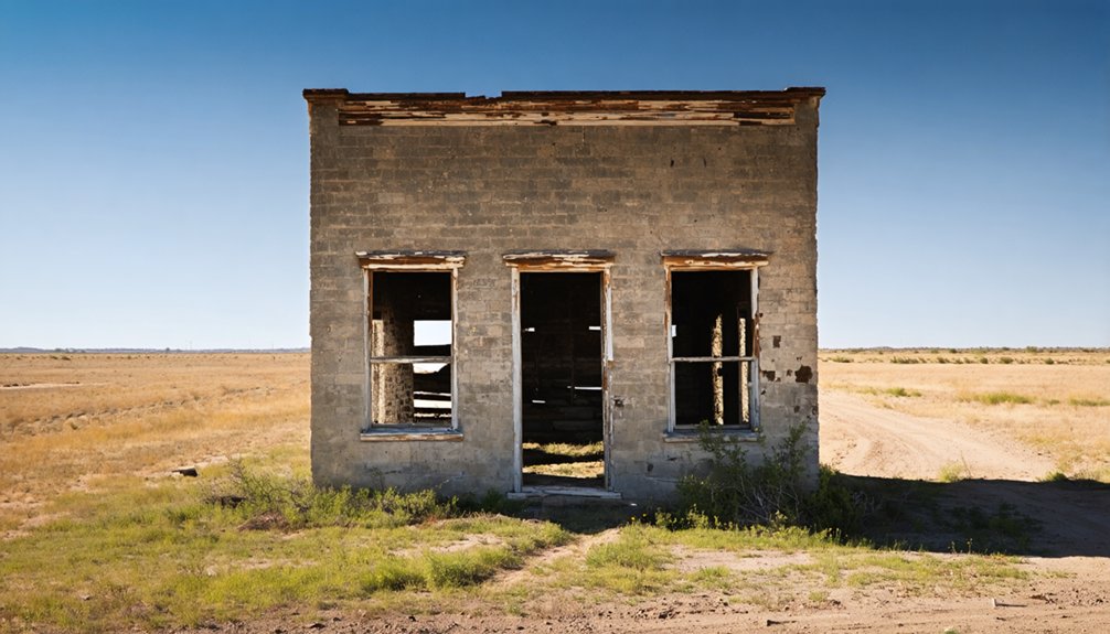
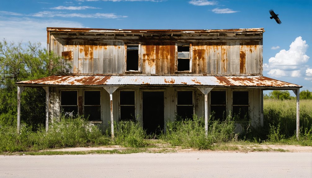
Notable Structures and Landmarks
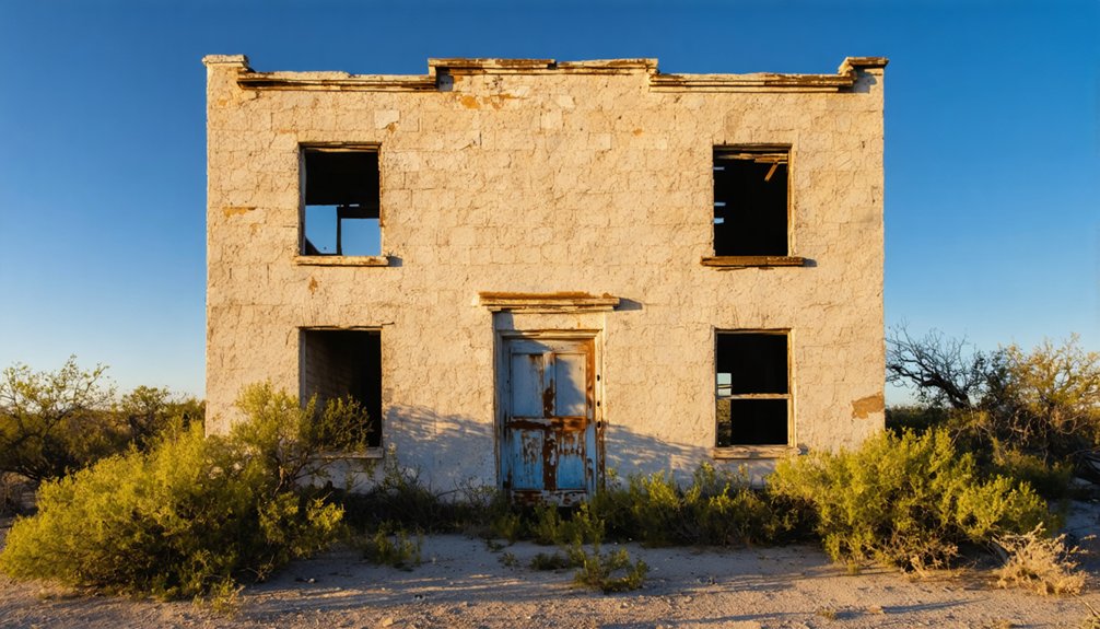
As you explore Carta Valley’s haunting remains, you’ll encounter a landscape dominated by the skeletal infrastructure of its mining past. The historical significance of structures like the W.W. Cole Building and Hicks-Cobb general store stands as evidence to the town’s brief prosperity.
Abandoned mines and crumbling storefronts tell silent stories of Carta Valley’s fleeting golden age in the American West.
Architectural features include local stone and wood construction, with remaining foundations scattered across the townsite revealing the scope of this once-bustling community.
- Multiple mine shafts pierce the rocky hills, some still accessible through gated entrances complete with original timber supports and mining cages.
- Distinctive waste rock piles and tailings shape the terrain, marking the locations of former mining operations.
- Commercial building ruins, including banks and pharmacies, retain original fixtures that offer glimpses into daily life during the mining boom.
Frequently Asked Questions
What Wildlife Species Are Commonly Found in the Carta Valley Area?
You’ll spot abundant wildlife through observation, from white-tailed deer and coyotes to green jays and bobcats. The species diversity includes Texas tortoises, horned lizards, and numerous migratory birds.
Are There Any Paranormal Stories or Legends Associated With Carta Valley?
You won’t find documented ghostly encounters or historical hauntings specific to this area. Unlike many Texas ghost towns with rich paranormal folklore, there aren’t any widely known supernatural tales here.
What Is the Average Property Value and Cost of Living Today?
You’ll find properties averaging $254,800, with land around $2,395/acre. Living expenses mirror rural Texas, though you’re free from city prices – just don’t expect your nearest grocery store next door.
Do Any Descendants of Ed Carta Still Live in the Region?
You won’t find verified Carta descendants in the region today, as public family history records don’t confirm any direct lineage still present, though some undocumented local connections might exist.
What Natural Disasters or Severe Weather Events Have Impacted Carta Valley?
You’ll find records of devastating floods throughout the region’s history, particularly in 1882 when waters rose 45 feet. Tornadoes and severe storms have also struck, damaging homes and properties around Carta Valley.
References
- https://www.county.org/county-magazine-articles/summer-2025/ghost-towns
- https://mix941kmxj.com/the-strange-sad-story-of-a-texas-ghost-town-youll-never-visit/
- https://www.youtube.com/watch?v=phjUE19A8HM
- https://texashighways.com/travel-news/four-texas-ghost-towns/
- https://en.wikipedia.org/wiki/Carta_Valley
- https://en.wikipedia.org/wiki/List_of_ghost_towns_in_Texas
- https://www.texasescapes.com/TexasHillCountryTowns/Carta-Valley-Texas.htm
- https://www.tshaonline.org/handbook/entries/carta-valley-tx
- https://www.texasescapes.com/TOWNS/Texas-Ghost-Towns-3-Hill-Country.htm
- https://kids.kiddle.co/Carta_Valley


