You’ll find Castle Rock’s haunting remains scattered across South Dakota’s Black Hills, where gold fever struck in 1875 along Whitewood Creek. The once-bustling mining town thrived through railroad connections and coal operations until the early 1900s, when depleted resources led to its decline. Today, weathered buildings and rusted mining equipment dot the remote prairie landscape at 6,783 feet elevation, offering glimpses into the frontier’s golden era for those who venture deeper.
Key Takeaways
- Castle Rock emerged during the 1875 Black Hills gold rush and later developed coal mining operations through the Firesteel Coal Company.
- Located at 6,783 feet elevation in the Black Hills, the town features abandoned mines, weathered buildings, and rugged limestone formations.
- The town’s economy relied heavily on mining until the early 1900s when high-grade ore depletion led to its eventual decline.
- Remnants include deteriorating structures, rusted stamp mills, and abandoned mine shafts scattered across the prairie landscape.
- Visitors can explore the ghost town’s mining heritage through self-guided tours, though no formal amenities exist at the site.
The Rise and Fall of a Mining Frontier
When gold was discovered in the Black Hills region near Castle Rock in 1875, it sparked one of South Dakota’s most significant mining rushes.
You’ll find that prospectors initially focused on placer mining techniques along Whitewood Creek, quickly expanding north toward Deadwood. The Homestake claim of 1876 proved to be the region’s richest discovery, transforming the area’s economic landscape. The area became a major contributor to South Dakota’s gold production, with 31.2 million ounces produced by 1965.
The Black Hills mining rush began with simple creek-side operations before the legendary Homestake strike changed everything in 1876.
The 1868 treaty withdrawal allowed an influx of white settlers to enter the region legally. As mining techniques evolved from simple placer operations to sophisticated hard rock extraction, you’ll notice how the region’s fortunes followed dramatic economic fluctuations.
While the Homestake Mining Company flourished under George Hearst’s leadership, smaller operations struggled. By the early 1900s, most mines had depleted their high-grade ore, though some diversification occurred with the development of the Firesteel coal fields in 1907, employing over 60 workers by the 1920s.
Railroad Legacy and Economic Impact
As railroad companies carved their routes through South Dakota’s frontier in the late 1870s, they wielded extraordinary power over Castle Rock’s destiny.
The railroad’s influence extended far beyond mere transportation – it determined which communities would thrive and which would fade into obscurity. Like many local speculators, investors eagerly purchased land along anticipated rail routes hoping to profit from future development.
You’ll find Castle Rock’s story echoes throughout the region, where economic shifts followed the rail lines’ paths. The discovery of gold in Custer’s 1874 expedition sparked a dramatic increase in railroad development throughout the Black Hills.
When major carriers like the Chicago and North Western chose their routes, they bypassed some established settlements while creating new ones on land owned by their preferred partners.
The railroads transformed the area’s economic landscape by enabling year-round transport of mining products and agricultural goods to distant markets.
Yet for Castle Rock, like many frontier settlements, survival hinged entirely on securing that essential rail connection.
Gold Rush Era Remnants
You’ll find weathered remnants of the gold rush scattered throughout Castle Rock’s creek valley, where rusted stamp mills and abandoned mine shafts mark the landscape’s mining heritage.
The skeletal frames of ore processing equipment still stand as silent sentinels, including partially intact crushers and amalgamation tables that once separated precious metals from raw ore. The discovery was sparked by Custer’s 1874 expedition that first revealed gold in the region. These processing sites were crucial for extracting the abundant free milling gold found throughout the area.
Along the creek bed, you can spot the deteriorating remains of old dredging operations that churned through tons of sediment in search of placer gold deposits during the Black Hills boom.
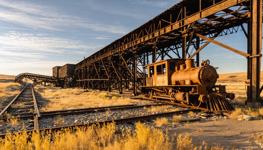
Mining Equipment Still Standing
Several significant pieces of mining equipment from the Black Hills Gold Rush still stand at Castle Rock, offering visitors a glimpse into the area’s rich mining heritage.
You’ll find weathered remnants of massive stamp mills that once crushed gold-bearing quartz, their rusted frameworks evidence to the region’s mining prowess. The stone foundations of mining machinery reveal the impressive scale of historic ore processing operations. You can spot scattered remains of steam boilers, ore hoists, and mercury amalgamation equipment throughout the site. The cyanide process technology introduced around 1900 revolutionized how these mills handled complex ores. Early operations relied on compressed air locomotives after 1901 to transport materials instead of animals.
Equipment preservation efforts have helped maintain these relics, including compressed air locomotive parts and water management systems.
Nearby mining museums showcase reconstructed versions of the tools and machinery that powered Castle Rock’s golden age, helping you understand the technological evolution from simple placer mining to advanced industrial operations.
Abandoned Mills and Shafts
The historic Black Hills gold rush left an indelible mark through Castle Rock’s abandoned mills and mine shafts, with the Ross and No. 5 shafts standing as proof to the region’s ambitious underground operations.
Modern cyanide milling operations revolutionized gold extraction before the site’s closure. The area thrived when the Chicago Burlington Railroad arrived in 1889, enabling more efficient ore transport. You’ll find mining artifacts scattered throughout the landscape, where the Mystic Mill‘s foundations now support what became a long-running sawmill operation. The abandoned structures tell a story of economic evolution from gold to timber.
- Ross Shaft plunges 5,000 feet deep at Lead’s southern edge
- No. 5 Shaft extends to 6,800 feet, primarily for ventilation
- Mystic Mill’s foundations were repurposed for the Sanford brothers’ sawmill in 1918
- The Etta Mine yielded valuable tin and spodumene until the 1950s
- Railroad grades and logging lines trace the paths of former mining operations
Creek Valley Dredge Remains
Massive steel buckets and rusted machinery from Castle Rock’s historic Creek Valley dredge remain partially submerged in Castle Creek, marking an ambitious industrial-scale gold mining operation that ran from 1911 to 1914.
You’ll find evidence of this advanced dredge technology scattered across the valley floor – from the barge’s skeletal ribs to towering waste rock piles that transformed the landscape.
The 78-bucket dredge represented cutting-edge industrial mining for its time, capable of moving 55,000 cubic yards of earth monthly to reach deep gold deposits that had frustrated earlier prospectors.
While the operation’s lifespan proved brief, its physical legacy endures in the creek bed’s altered contours and dredging ponds.
The venture coincided with regional railroad expansion, which supplied the massive operation until its eventual dismantling and relocation.
Life in Castle Rock’s Heyday
You’d find Castle Rock at its peak bustling with railroad crews and mining families who transformed the once-quiet valley into a vibrant community hub.
The town’s commercial district came alive with the daily traffic of miners heading to their shifts, railroad workers maintaining the crucial northbound line, and merchants serving the growing population.
While life was undeniably harsh, with many families living in simple worker housing near the mines and railroad yards, the town managed to support essential services like supply points for freight wagons and basic amenities for its hardworking residents.
Mining Families Daily Life
Life in Castle Rock’s mining heyday revolved around the demanding rhythms of frontier mining, where families carved out modest existences in timber cabins clustered near the mines.
You’d find family roles clearly defined, with men working long hours underground while women managed households with remarkable resourcefulness. Daily routines centered on survival and sustenance, from hauling water to tending small gardens that supplemented basic provisions of flour, beans, and salted meats.
- Men faced hazardous conditions underground, working physically demanding shifts in the mines.
- Women maintained homes, prepared meals, and often contributed to community support networks.
- Children helped with chores and sometimes lighter mining-related tasks.
- Families relied on irregular supply deliveries via stagecoach and freight wagons.
- Social life centered around informal gatherings, sharing resources, and community cooperation.
Railroad Workers’ Community Hub
As Castle Rock flourished during its heyday, the railroad depot emerged as the beating heart of the community, drawing workers and families into its orbit of constant activity.
You’d find the depot bustling with immigrants, particularly Norwegians, who’d formed tight-knit bonds through their shared railroad labor. The daily rhythm of life pulsed around train schedules, with workers gathering to collect mail, send telegrams, and exchange news.
Railroad camaraderie flourished as community gatherings centered on this essential hub. You’d witness farmers delivering grain, workers maintaining tracks, and families connecting through the depot’s social atmosphere.
The surrounding businesses – from general stores to boarding houses – created a support network that sustained Castle Rock’s growth. This integration of work and social life defined the town’s character until post-World War II changes diminished rail traffic.
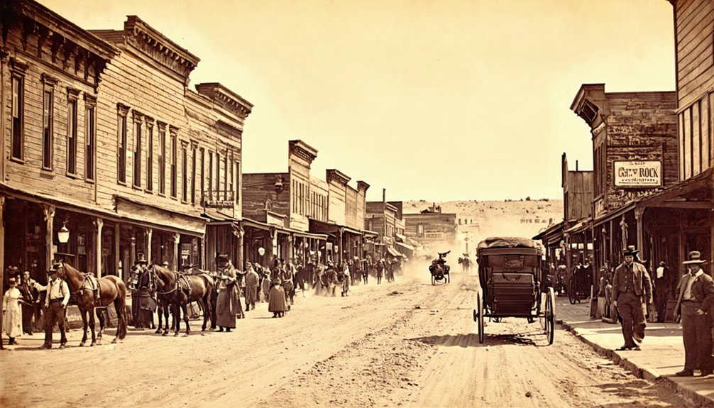
Thriving Commercial District
Three distinct commercial zones anchored Castle Rock’s bustling main street during its peak years from 1910 to 1940.
The town’s commercial history evolved from a simple stagecoach stop into a vibrant frontier marketplace, where you’d find everything from essential supplies to social gathering spots. The business evolution reflected the needs of both locals and travelers, creating a self-sustaining economic ecosystem.
- A prominent hotel served as both stagecoach stop and social hub
- The Castle Rock Press, established in 1912, kept residents informed of local happenings
- General stores stocked farming supplies and staple goods for the surrounding region
- Local saloons doubled as community gathering spaces for traders and residents
- The post office, operating until 1972, connected Castle Rock to the wider world through commerce and communication
Mining Operations and Technology
Mining operations in Castle Rock evolved from humble beginnings into a sophisticated enterprise, marked by the early coal mining efforts of Andrew Traversie and William Benoist in 1907.
You’ll find that mining technology rapidly advanced when the Firesteel Coal Company transformed local operations in 1923, employing over 60 men and achieving annual shipments exceeding 40,000 tons.
The coal extraction network expanded remarkably, reaching markets as far as Iowa.
Architectural Remains and Structures
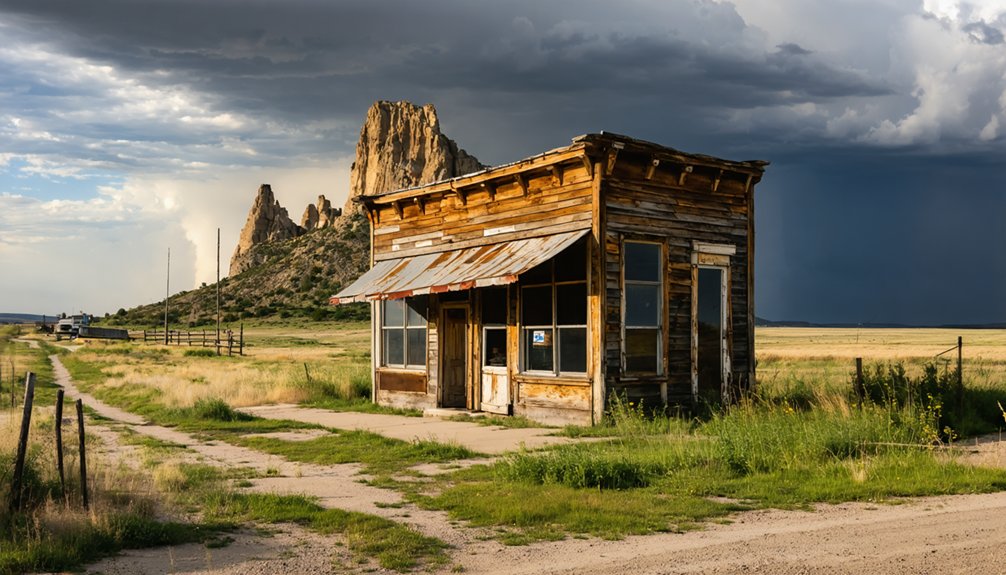
The architectural remnants of Castle Rock offer a ghostly glimpse into the once-thriving coal mining community. The site’s architectural decay is evident in its roofless buildings, collapsed walls, and weathered foundations.
You’ll find typical Black Hills construction methods throughout, with local timber and stone serving as the primary building materials. While historical preservation efforts haven’t been extensive, the remaining structures tell the story of a bustling mining settlement.
- Abandoned miners’ cabins and office buildings scatter the landscape
- Heavy timber-framed mill structures and elevated tramway remains
- Stone foundations and chimneys marking former residential areas
- Weather-worn wooden frame houses in various states of collapse
- Industrial ruins featuring brick and stone foundations from mining operations
Natural Setting and Geographic Features
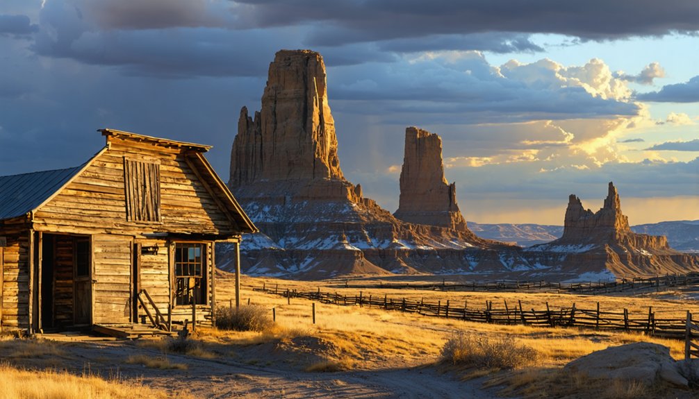
You’ll find Castle Rock nestled in a distinctive valley on the northeastern edge of South Dakota’s Black Hills region, where the rugged landscape shifts into rolling prairie.
The area’s natural features have been shaped by both geological forces and the region’s mining heritage, with Castle Rock Butte rising prominently above the modified terrain.
As you explore the ghost town‘s setting, you’ll notice how the historic mining operations left their mark on the original landscape while preserving the dramatic views of the surrounding buttes and grasslands.
Black Hills Valley Location
Nestled within South Dakota’s picturesque Black Hills, Castle Rock ghost town sits at an impressive elevation of 6,783 feet, surrounded by limestone formations and dense forests.
As visitors explore the remnants of this once-thriving community, they often come across abandoned structures in Gold Hill that evoke a sense of nostalgia. The rugged landscape and silent homes tell stories of a bygone era, inviting hikers to imagine life in the town during its peak. With nature reclaiming the land, these decaying sites serve as a striking contrast to the vibrant surroundings.
From this vantage point, you’ll discover some of the region’s most stunning scenic views, including Twin Sisters Peak and the expansive Deerfield Lake valley. The landscape features a complex network of waterways, with Castle Creek winding through gulches before joining Rapid Creek.
- Castle Creek flows for 14 miles through rugged terrain
- Dense forests and meadows blanket the surrounding peaks
- Deerfield Reservoir’s waters reflect the mountain scenery
- Twin Sisters Peak stands as a prominent geological landmark
- Castle Creek gulch carves through ancient limestone formations
Mining-Altered Landscape Features
Mining operations have dramatically reshaped Castle Rock’s natural landscape since the area’s first mineral discoveries.
You’ll find evidence of landscape evolution throughout Castle Creek’s drainage system, where gold and gravel extraction have altered the original terrain. The South Fork particularly shows significant sediment disruption from extensive gravel mining.
As you explore the area, you’ll notice how mining has transformed the natural badlands around Castle Rock Butte, creating distinctive cuts and excavations in the limestone cliffs.
The region’s karst geology, with its network of underground caves and springs, has been impacted by mining activities that’ve changed groundwater patterns.
Mining tailings and waste rock have formed artificial hills and depressions, while stream channels show modified courses from years of mineral extraction.
Transportation Routes and Access
Located within South Dakota’s remote terrain, Castle Rock remains accessible through a network of state routes and U.S. highways that connect to major regional cities.
The transportation infrastructure presents access challenges, with driving distances spanning 640-660 miles from major South Dakota cities. You’ll find State Route 79 and US 18 serving as primary corridors through the mountainous Black Hills region.
- Rapid City Regional Airport (RAP) offers the closest major air access, with connections to Denver International.
- Drive times range from 6-7 hours from Spearfish to 10-11 hours from Sioux Falls.
- Local taxis and rental cars bridge the gap from regional transit hubs.
- Scenic byways near Native American cultural sites provide alternative routing options.
- Limited public transit means private vehicle access is your most reliable option.
Historical Significance in the Black Hills
As sacred ground to the Lakota Sioux and other indigenous peoples, the Black Hills region surrounding Castle Rock holds profound historical significance that stretches back centuries before European settlement.
You’ll find layers of cultural heritage here, from the Lakota’s spiritual connection to the land following their 1776 conquest of the Cheyenne to the transformative gold rush era of the 1870s.
The area’s history embodies the clash between indigenous rights and westward expansion, as the U.S. government violated the Fort Laramie Treaty of 1868 to seize these sacred lands.
The subsequent gold rush brought waves of miners to places like Castleton, creating boom-and-bust cycles that shaped settlement patterns and left behind ghost towns that dot the landscape today.
Modern-Day Ghost Town Experience
Today’s visitors to Castle Rock will find a hauntingly quiet prairie landscape dotted with weathered buildings and scattered remnants of its mining-era past.
Your ghost town exploration here offers an authentic glimpse into South Dakota’s frontier heritage, though minimal historical preservation efforts mean you’ll need to rely on your imagination and self-guided discovery.
- You’ll encounter abandoned structures across open prairie land, with no formal paths or markers
- Bring your camera – the site offers compelling photography opportunities against the Black Hills backdrop
- Plan for self-sufficiency as there aren’t any visitor amenities or services nearby
- Exercise caution around deteriorating structures and uneven terrain
- Visit during clear weather for the best visibility of remaining buildings and ruins
Frequently Asked Questions
Are There Any Reported Ghost Sightings or Paranormal Activities in Castle Rock?
You’ll find documented ghost encounters in Castle Rock’s Old Stone Church and Cantril School House, where spectral legends include Matilda’s footsteps, mysterious noises, self-opening doors, and unexplained buzzing sounds.
What Native American Tribes Originally Inhabited the Castle Rock Area?
Like waves of time, you’ll find the Arikara were first, followed by Cheyenne, Crow, Kiowa, and Arapaho. The Wahpekute Dakota later settled there before the Lakota claimed this cultural heritage.
Did Any Famous Outlaws or Historical Figures Visit Castle Rock?
You won’t find records of famous outlaws or notable figures visiting Castle Rock. Unlike nearby Deadwood, this railroad settlement’s historical significance centered on industrial activity rather than out
What Were the Most Common Causes of Death in Castle Rock?
You’d find disease outbreaks were the deadliest killers, especially typhoid and tuberculosis from poor sanitation. Mining accidents claimed many lives too, with shaft falls and equipment crushings particularly common.
Were There Any Significant Natural Disasters That Affected Castle Rock?
Looking for dramatic natural disasters? You won’t find them here. Historical records don’t show any significant natural disasters impacting Castle Rock – the town’s decline stemmed from economic factors like failed mining ventures and railroad changes.
References
- https://www.sdpb.org/rural-life-and-history/2023-08-21/some-black-hills-ghost-towns-and-their-origins
- https://www.sdhspress.com/journal/south-dakota-history-2-2/some-black-hills-ghost-towns-and-their-origins/vol-02-no-2-some-black-hills-ghost-towns-and-their-origins.pdf
- https://en.wikipedia.org/wiki/List_of_ghost_towns_in_South_Dakota
- https://history.sd.gov/preservation/docs/RuralButteMeadeCo.pdf
- https://www.youtube.com/watch?v=FhVmwfOEagk
- https://www.onlyinyourstate.com/experiences/south-dakota/abandoned-neighborhood-sd
- http://www.penryfamily.com/geographicalcenters/castlerock.html
- https://history.sd.gov/docs/Mining.pdf
- https://history.sd.gov/museum/docs/Mining.pdf
- https://blackhillsminingmuseum.com/learn/history


