You’ll find the ruins of Catamount ghost town in Massachusetts near Pocumtuck Mountain, where Revolutionary War veterans established a farming settlement in the late 18th century. The town gained national significance in 1812 when its schoolhouse became the first to fly the American flag. Despite the community’s initial success, harsh terrain, poor farming conditions, and isolation led to its abandonment by the early 1900s. Today, you can explore the remnants within Catamount State Forest, where historic foundations and a stone marker tell a compelling tale of pioneer life.
Key Takeaways
- Catamount was an 18th-century settlement near Pocumtuck Mountain that became abandoned by the early 20th century due to harsh farming conditions.
- The settlement gained historical significance in 1812 when its schoolhouse became the first American public school to raise the U.S. flag.
- Poor soil conditions, steep terrain, and geographic isolation made farming unsustainable, leading to gradual population decline and eventual abandonment.
- The area transformed into Catamount State Forest in 1967, now offering hiking trails, snowmobiling, and fishing opportunities at McLeod Pond.
- Visitors can explore stone markers, foundation ruins, and historic remnants, though access requires careful preparation due to rugged terrain.
The Rise of a Farming Settlement
While neighboring Colrain had established itself by the mid-1730s, Catamount’s settlement didn’t begin until several decades later when Revolutionary War veterans sought affordable land in the remote terrain of Massachusetts.
Like the early Scotch-Irish Presbyterians who first settled in the region, these pioneering settlers faced formidable challenges as they implemented their settlement strategies on Catamount Hill’s rocky landscape. You’ll find that each family received a 50-acre plot where they’d to build homes, clear five acres, and establish fencing.
Their community resilience showed through their commitment to civic development, constructing a schoolhouse that would later become a symbol of patriotic pride. The schoolhouse notably flew the U.S. flag in 1812, marking an early display of national allegiance.
Despite the stony soil limiting most farming to potato cultivation, these determined veterans created a self-sufficient community in the wilderness north of Deerfield Valley, demonstrating remarkable fortitude in the face of harsh conditions.
Life in Early Catamount Village
Life in early Catamount Village embodied the quintessential rural New England experience, marked by self-sufficiency and tight-knit community bonds.
You’d find farming families working their required five-acre plots, building sturdy homes at least 18 feet square to meet settlement requirements. The village’s community dynamics centered around the historic schoolhouse, where local children gathered for education and where America’s first schoolhouse flag would later fly. The school flag’s historic moment occurred in 1812, setting a patriotic precedent for the nation.
Social interactions flourished despite the remote, mountainous setting. You’d witness neighbors coming together for events near Pocumtuck Mountain, sharing resources, and supporting one another through harsh weather and challenging terrain. The villagers remained vigilant of mountain lions’ steep habitat, as these predators were known to favor the canyons and dense brush of the region.
The primarily Scotch-Irish Presbyterian influence shaped the community’s religious character, while the isolated geography fostered a spirit of independence and resilience among Catamount’s inhabitants.
The Historic Schoolhouse and First American Flag
The historic schoolhouse atop Catamount Hill gained national significance in May 1812 when local Republicans raised the first American flag ever flown over a public school.
You can imagine the schoolhouse’s commanding position, deliberately chosen by Scotch-Irish Presbyterian settlers who valued education in this Massachusetts frontier wilderness.
The flag they raised wasn’t just any banner – it was a rare 17-star, 17-stripe version representing each state in the Union. Its symbolism carried weight as Republicans defied local Federalist opposition, declaring their loyalty to the young republic.
A bold statement of patriotism unfurled in seventeen stars and stripes, defying local opposition to champion America’s democratic ideals.
Local farmers initiated this patriotic display to counter the strong Federalist presence in the area.
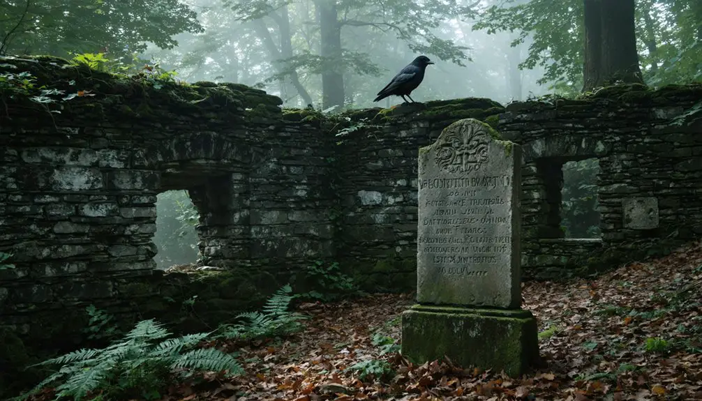
While the original schoolhouse no longer stands, its legacy lives on through a monument marking where these patriots made history.
The Massachusetts Historical Society confirmed this event’s schoolhouse significance as the earliest documented flag-raising at an American public school.
The historic flag was crafted by four local women including Rhoda Shippee, Lois Shippee, Sophia Willis, and Stephen Hale’s wife.
Agricultural Challenges in Remote Terrain
Farming in Catamount’s rugged terrain posed formidable challenges that shaped early settlers’ agricultural practices. You’ll find evidence of their terrain adaptation strategies in the remaining stone walls and terraced hillsides, where they fought against nature’s harsh constraints. The north-facing slopes experienced significantly reduced sunlight exposure, creating additional challenges for crop selection and growth cycles. Modern farmers could have benefited from using agricultural films to regulate soil temperature and retain moisture in these difficult conditions.
The steep slopes reduced crop yields by up to 40%, forcing settlers to implement creative erosion control methods.
- Farmers constructed intricate terracing systems to transform treacherous 8%+ gradients into manageable agricultural plots
- Limited road access meant higher costs for transporting seeds and equipment, making self-sufficiency vital
- Remote location required modified irrigation techniques and specialized tools for working the uneven landscape
These agricultural hurdles ultimately contributed to Catamount’s abandonment, as farmers struggled to maintain profitable operations in such challenging topographical conditions.
The Path to Abandonment
You’ll find Catamount’s path to abandonment rooted in its extreme geographic isolation near Pocumtuck Mountain, where treacherous terrain and limited access severely restricted trade and development opportunities.
The village was historically significant as the location of the first American flag to be flown at a schoolhouse.
The village’s agricultural foundation crumbled as poor soil conditions and harsh climate made farming increasingly unsustainable by the late 19th century.
These environmental and economic pressures triggered a steady exodus of residents seeking better opportunities, leading to the village’s complete abandonment by the early 20th century. The area eventually became Catamount State Forest in 1967.
Geographic Isolation Impacts
Situated in a remote corner of Colrain, Massachusetts, Catamount’s geographic isolation proved to be its ultimate undoing. Nestled in challenging mountainous terrain, the settlement struggled with both economic isolation and social isolation that severely limited its potential for growth and sustainability.
The harsh realities of Catamount’s remote location manifested in several critical ways:
- Limited access to markets and essential services forced residents to travel long distances for basic necessities.
- Lack of reliable transportation routes prevented economic diversification beyond subsistence farming.
- Absence of social connections and community services drove younger generations to seek opportunities elsewhere.
You can trace the town’s decline directly to these geographic challenges, which not only restricted development but also accelerated outmigration until Catamount’s complete abandonment.
Today, the former settlement exists as part of Catamount State Forest, where its isolated nature now serves conservation rather than civilization.
Limited Agricultural Prospects
While the geographic isolation of Catamount posed significant challenges, the settlement’s agricultural limitations ultimately sealed its fate.
You’d have struggled to farm the rocky terrain, where steep slopes and poor soil quality made plowing nearly impossible. The harsh climate limited your growing season to less than five months, with early frosts destroying vulnerable crops before they’d mature.
Without agricultural diversity or effective crop rotation, you couldn’t sustain more than subsistence-level farming. The land simply wouldn’t yield enough to create an economic surplus.
Your livestock options were equally restricted by limited pastureland and long winters requiring additional feed. As beavers reclaimed portions of McLeod Pond and swamps expanded, you’d watch helplessly as nature transformed once-arable land back to wilderness.
Population Exodus Timeline
Although Catamount initially flourished as a small farming settlement in the mid-1700s, its population trajectory followed a predictable path toward abandonment over the next two centuries. The village’s once-thriving community dynamics shifted as traditional farming techniques proved inadequate for the challenging terrain and isolated location.
- 1700s-1800s: A stable population of hardy farmers carved out a living, establishing homesteads and marking their presence with the first American flag-flying schoolhouse in 1812.
- Late 1800s: The younger generation began seeking opportunities elsewhere as economic prospects dwindled.
- Early 1900s: Final families departed, dismantling and relocating their homes to nearby towns.
Legacy in Massachusetts History
Since its establishment in the mid-18th century, Catamount has left an indelible mark on Massachusetts history through its agricultural heritage and patriotic milestones.
You’ll find its cultural significance woven into historical narratives that showcase early American rural life and community resilience in New England’s challenging terrain.
The village’s proudest achievement came in 1812 when its schoolhouse became the first in America to fly the national flag.
Today, you can explore this legacy at Catamount State Forest, where a stone marker commemorates this patriotic milestone.
While the village’s physical structures have vanished, Catamount’s story continues to educate visitors about the patterns of settlement and decline in post-colonial Massachusetts, serving as a reflection of the pioneering spirit of early American settlers.
Transformation Into Catamount State Forest
You’ll find the roots of Catamount State Forest in a pivotal 1967 land transfer, when Massachusetts acquired the former power company holdings around Catamount Hill and McLeod Pond.
The state’s designation of the area as Catamount State Forest brought new life to the abandoned settlement, establishing it as part of the Mohawk Trail State Forest system with a focus on conservation and low-impact recreation.
While vehicular access became restricted and formal facilities remained minimal, the forest now welcomes visitors for activities like hiking, snowmobiling, and fishing at McLeod Pond.
Conservation Efforts Begin
During the late 1960s, the Commonwealth of Massachusetts transformed Catamount’s abandoned landscape by acquiring the ghost town’s land in 1967 and establishing Catamount State Forest.
Conservation policies focused on preserving both natural habitats and historical remnants while ensuring sustainable public access. Under Mohawk Trail State Forest jurisdiction, you’ll find extensive ecological impact management strategies that protect the region’s biodiversity.
Key conservation initiatives include:
- Reforestation of native tree species and wetland preservation around McLeod Pond
- Protection of historic cellar holes and artifacts that tell the story of 18th-19th century rural life
- Development of sustainable trails for hiking and snowmobiling while preventing site degradation
These efforts have successfully balanced public recreation with the preservation of Catamount’s natural and historical heritage, ensuring its legacy for future generations.
Recreational Areas Emerge
After its acquisition by Massachusetts in 1967, Catamount State Forest transformed the abandoned ghost town into a vibrant recreational destination spanning over 1,000 acres in Southwestern Colrain.
You’ll find an extensive network of trails perfect for hiking, mountain biking, and winter sports, including a 50-mile groomed snowmobile loop. The forest’s natural features support diverse recreational activities from fishing and swimming to canoeing on the scenic pond.
Historical remnants like old railroad beds and foundations provide unique landmarks along the trails, while the iconic catamount sculpture at the entrance pays tribute to the area’s wildlife heritage.
The forest serves as an outdoor education hub, where local schools conduct field trips to teach regional history and environmental stewardship, seamlessly blending recreation with learning opportunities.
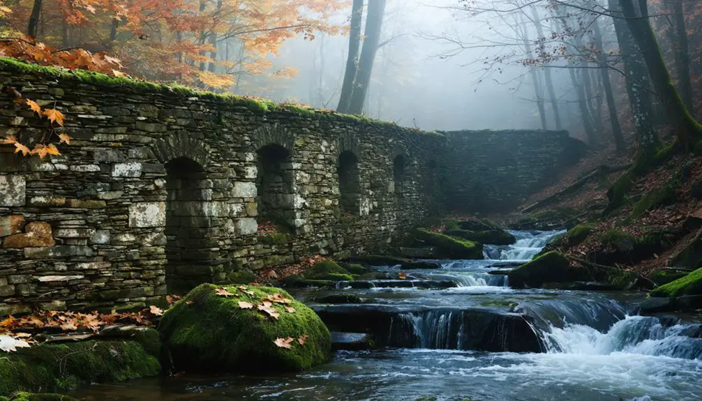
Remaining Traces and Landmarks
While most ghost towns leave behind substantial ruins, Catamount’s primary physical remnant is a solitary stone marker indicating the location of its historic schoolhouse – the first in America to fly the U.S. flag in 1812.
Beyond this marker of historical significance, you’ll find scattered community remnants throughout the forested landscape:
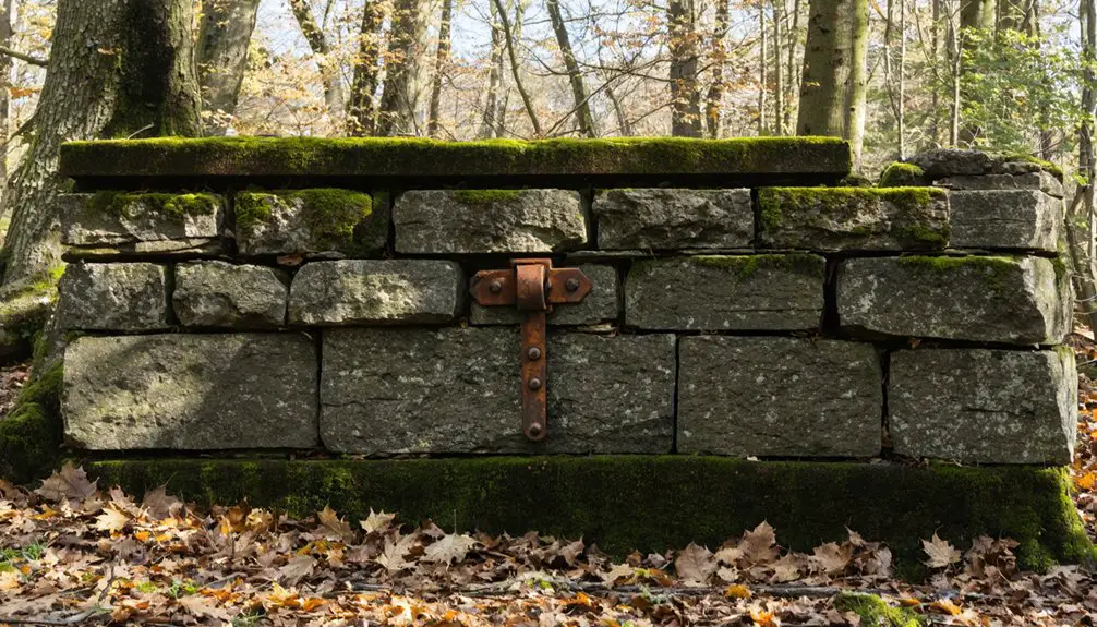
- Stone walls and cellar holes mark where farms and homesteads once thrived
- Foundation ruins of an old rubber factory hint at the village’s industrial past
- McLeod Pond, still a prime spot for fishing and canoeing, connects past to present
You can explore these traces along well-marked hiking trails within Catamount State Forest, though you’ll need to travel on foot since vehicle access is restricted.
The mountainous terrain and dense forest have reclaimed most signs of the once-vibrant farming community.
Comparing Catamount to Other Ghost Towns
Unlike Whitewash Village’s sudden decline from a natural disaster that destroyed its harbor, Catamount’s abandonment stemmed from its increasingly impractical mountainous location in a modernizing Massachusetts.
You’ll find that while Dogtown became known for its social outcasts and mysterious reputation during its decline, Catamount maintained its character as a quiet farming settlement until its final abandonment.
The gradual economic isolation of Catamount stands in stark contrast to the dramatic environmental and social factors that hastened the end of other Massachusetts ghost towns.
Distinct Reasons for Abandonment
Throughout New England’s history, ghost towns emerged for various dramatic reasons – from submerged villages to abandoned mining camps – yet Catamount’s path to abandonment stands distinctly apart.
Unlike towns destroyed by natural disasters or government projects, Catamount’s decline stemmed from the quiet erosion of its farming techniques and community dynamics in an isolated mountain setting.
- While fishing villages like Whitewash struggled with depleted resources, Catamount’s agricultural foundation simply couldn’t sustain modern demands.
- The town lacked the social infrastructure – taverns, markets, or gathering places – that helped other communities adapt and survive.
- Unlike Dogtown’s dramatic tales of witchcraft accusations, Catamount’s story is one of gradual exodus as families sought better opportunities elsewhere.
The state’s 1967 land acquisition sealed Catamount’s fate, transforming farmland into forest rather than allowing potential renewal.
Geographic Isolation Vs Disaster
The stark contrast between Catamount’s slow decline and other Massachusetts ghost towns reveals how geography shaped their destinies.
While coastal settlements like Whitewash Village and Dogtown succumbed to sudden environmental catastrophes that destroyed harbors and altered shorelines, Catamount’s story showcases a different path to abandonment.
You’ll find that Catamount’s natural resilience against disasters couldn’t protect it from the grinding effects of geographic isolation.
Its remote mountain location, while shielding it from coastal storms, created barriers to trade and development.
Unlike the rapid exodus seen in storm-ravaged coastal towns, Catamount experienced a gradual economic migration as residents sought better opportunities elsewhere.
The mountainous terrain that once protected the settlement ultimately became its greatest challenge, leading to a slow but inevitable decline into abandonment.
Modern Day Exploration and Access
Modern explorers seeking to visit Catamount ghost town will find it nestled in Colrain, Massachusetts, near Griswoldville’s southwest section. While Catamount Hill Road and Stacy Road offer partial vehicle access, most modern exploration requires traveling by foot due to erosion-damaged roads.
You’ll discover longer access routes from Charlemont and Heath if you’re up for an extended adventure.
- The site’s now primarily Massachusetts State Forest land, offering unrestricted hiking through historic ruins and natural landmarks.
- McLeod Pond provides opportunities for fishing and canoeing within the ghost town’s boundaries.
- Winter opens up snowmobiling possibilities on designated trails.
Remember to respect “No Trespassing” signs on private property and prepare for rugged terrain.
There aren’t any facilities available, so pack essential supplies for your journey through this remote piece of history.
Frequently Asked Questions
Are There Any Old Photographs of Catamount Village Still in Existence?
You won’t find any confirmed old photographs of Catamount Village in public archives. While local historical societies might hold undiscovered Catamount photographs, there’s no readily available photographic evidence of the village’s history.
What Happened to the Families Who Originally Lived in Catamount?
You’ll find those families hitched up their wagons and left during economic decline, relocating to nearby towns and urban centers where they’d have better job opportunities and modern amenities.
Were There Any Cemeteries in Catamount, and Do They Still Exist?
You’ll find Old Farley Cemetery still exists between South Catamount Hill Road and Houghton Brook, preserving burial traditions of early residents. It’s the only documented cemetery location in the area.
What Native Tribes Originally Inhabited the Catamount Area Before Settlement?
You’ll find the Neponset band of the Massachusett tribe were the primary inhabitants of this area, with their cultural significance deeply rooted in the land before European settlers arrived in eastern Massachusetts.
Did Any Famous Historical Figures Ever Visit or Stay in Catamount?
You’ll find only one documented famous visitor to the area: Massachusetts Governor John Davis Long, who attended the Old Home Days festival near Catamount in 1880 on Pocumtuck Mountain.
References
- https://bostonuncovered.com/ghost-towns-massachusetts/
- https://historyofmassachusetts.org/ghost-towns-massachusetts/
- https://newenglandhistoricalsociety.com/six-new-england-ghost-towns/
- https://wsbs.com/this-ma-village-has-been-deemed-as-a-ghost-town/
- https://lostmassachusetts.com/f/catamount-mass-e93
- https://www.colrainhistoricalsociety.org/colrain-a-history/
- https://www.sunjournal.com/2005/09/25/knowing-catamount/
- https://en.wikipedia.org/wiki/Catamount
- http://www.tnbdomeball.com/image storage/smack and coolstuf and supe and poems/catamount.html
- https://www.franklinsites.com/catamount/