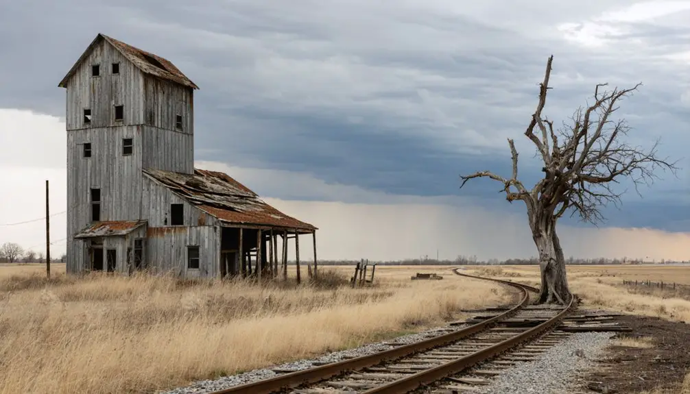
You’ll find Clayton’s ghost town remnants in Faribault County, Minnesota, where it was established in 1860. The township flourished briefly after its 1873 organization but faced decline due to land speculation and agricultural challenges. Early settlers built sod houses and operated farms, including W.Z. Clayton’s 960-acre spread and D.B. Colman’s 1,280 acres. While the post office once served as a vibrant community hub, today only scattered traces reveal Clayton’s frontier legacy.
Key Takeaways
- Clayton Township faced rapid decline due to land speculation and crop failures, leading to widespread farm abandonment in the late 1800s.
- Poor soil conservation practices and environmental degradation contributed to the area’s transformation into a ghost town.
- The township’s initial promising settlement in 1873 was undermined by economic instability and limited access to markets.
- Buildings were relocated from Clayton to more prosperous towns, leaving behind vacant properties and deteriorating structures.
- The closure of Clayton’s post office, which had served as the community hub since 1860, marked a significant step in its ghost town status.
The Rise and Fall of a Frontier Settlement
While land speculators initially dominated Clayton Township’s early development by buying up large tracts in the area, actual settlement didn’t begin in earnest until around 1870. To prevent misidentification with other locations, the settlement was formally registered as Clayton Township, Minnesota.
The speculative investments proved problematic for early settlers like John Johnson and Hiram Thompson, who struggled to establish themselves in the southwestern region. Many pioneers attempting to purchase land through time payments failed due to poor crop yields, forcing them to forfeit their properties back to speculators.
Despite these challenges, some large farms emerged, including W.Z. Clayton’s 960 acres and D.B. Colman’s 1,280 acres.
Settlement patterns remained sparse, though, and the township’s official organization in 1873 couldn’t prevent its eventual decline. The town’s gradual deterioration continued until only the cemetery remained by 1977.
Life in Early Clayton Township
Life in Clayton Township during its early years reflected the harsh realities of frontier existence, as settlers adapted to the challenges of prairie living through innovative housing solutions and agricultural practices.
You’d have found most families living in sod houses crafted from prairie turf, as timber was scarce until railroad access improved. Settler hardships included widespread crop failures and constant struggles with land speculators, who initially held much of the territory.
Despite these challenges, community resilience emerged through the township’s official organization in 1873. Large farms like Clayton’s 960 acres and Colman’s 1,280 acres demonstrated successful adaptation to frontier conditions. Early French fur traders had already established extensive trading networks in the region by the time settlers arrived.
You would’ve witnessed livestock roaming freely until the late 1870s when increased fencing efforts helped establish more organized farming operations. The township’s fertile dark rich loam soil proved ideal for growing various grasses and cereals, helping sustain the farming community.
Notable Pioneers and Community Leaders
Despite the challenges of frontier settlement, several key pioneers emerged as influential figures in Clayton Township’s development during the 1860s and 1870s. W.Z. Clayton, the township’s namesake, established a vast 960-acre operation, while D.B. Colman cultivated an impressive 1,280 acres. Their pioneer contributions shaped the agricultural landscape alongside early settlers John Johnson and Hiram Thompson.
The leadership dynamics shifted when the township officially organized in 1873, with elected supervisors managing local affairs. These officials faced complex challenges, including land speculation issues that hindered settlement growth. Like many Minnesota settlements, the town’s fate was heavily influenced by economic shifts and transportation changes.
They worked to stabilize the community through periods of economic hardship, crop failures, and population fluctuations. Despite these obstacles, their efforts helped transform Clayton from speculative holdings to productive farmland, though the township would ultimately fade into history. The area later became known for paranormal activity, particularly after unexplained events at the Gomez house in 1957.
The Role of Agriculture and Land Ownership
Clayton Township’s early land acquisition attracted speculators who delayed immediate settlement until the 1870s when they resold parcels to farmers.
You’ll find that many buyers who purchased land on credit defaulted due to devastating crop failures, causing properties to revert to speculative owners.
Large landholders emerged during this period, with notable examples like W.Z. Clayton’s 960-acre farm and D.B. Colman’s 1,280-acre holding, which shaped the township’s agricultural development patterns. The transformation of the land required extensive labor as settlers worked to break virgin prairie for cultivation. Like many ghost town communities, Clayton’s population dwindled due to economic challenges and resource depletion.
Early Farm Ownership Patterns
Agricultural development in Clayton Township followed an unusual pattern, as speculators initially purchased and held much of the available land, delaying settlement until after 1870.
You’ll find that when speculators finally sold their holdings, many new farmers couldn’t maintain payments due to poor crop yields, causing lands to cycle back to speculative ownership.
The township’s early farm ownership concentrated in the hands of a few prominent landowners. W. Z. Clayton controlled 960 acres, D. B. Colman owned 1,280 acres, and C. A. Merrill held 800 acres.
Rather than small family farms, these large consolidated properties dominated the agricultural landscape. The first settlers, including John Johnson and Hiram Thompson, arrived in 1864, but widespread settlement didn’t take hold until the township’s formal organization in 1873.
Failed Agricultural Settlement Impacts
While early settlers faced numerous economic hardships in Clayton Township, the failed agricultural settlements stemmed primarily from three interconnected factors: limited farming technology, restrictive land ownership models, and poor market access. Similar to the decline of ghost towns across Minnesota, economic instability drove many families away from their homesteads.
You’ll find that economic factors severely impacted settlement sustainability, as farmers struggled with inefficient tools and manual land clearing methods that drastically limited their productivity and potential for growth. Like many early Minnesota settlers, residents initially supported local post offices, hotels, and schools before economic decline forced them to abandon their properties.
- When you couldn’t own your farmland outright, you’d lose the incentive to invest in long-term agricultural improvements.
- Your farming success depended heavily on access to reliable transportation for crop distribution.
- Without modern planting and harvesting equipment, you’d face significant constraints on crop yields.
- If economic downturns hit, like the Panic of 1857, you’d likely lose your savings and be forced to relocate.
Environmental Challenges and Land Degradation

Environmental factors played a decisive role in Clayton’s eventual abandonment, with soil erosion from hillside farming serving as the primary catalyst for the town’s decline. Without proper soil conservation techniques, the hillsides lost their precious topsoil, transforming fertile farmland into swampy, unusable terrain.
You’ll find that erosion control measures were significantly absent during this critical period of settlement.
The region’s post-glacial landscape proved particularly vulnerable to degradation. As settlers cleared native forests and prairie grasslands, they unknowingly destabilized the fragile soil structure.
The combination of poor drainage, deforestation, and intensive farming practices led to severe land deterioration. These environmental pressures forced many residents to relocate, as their once-productive farmland could no longer sustain agricultural activities or support permanent settlement.
The Post Office Era: 1860-1899
Clayton’s post office opened its doors in 1860, establishing itself as a crucial communication hub during Minnesota’s critical settlement period.
You’d find residents gathering at the post office to collect their mail, exchange news, and maintain connections with the outside world through letters and parcels.
The facility’s role proved indispensable for 39 years, providing Clayton’s populace with mail service that linked them to larger Minnesota towns and facilitated both personal correspondence and business transactions.
Mail Service Establishment
During the early 1860s, as Minnesota embraced its newfound statehood, the establishment of a post office in Clayton marked a significant milestone in the town’s development.
The postal service emerged during a period of rapid frontier expansion, coinciding with the Homestead Act of 1862. You’ll find that Clayton’s post office wasn’t just a mail facility – it served as an essential hub in the region’s growing communication networks.
- Connected Clayton’s pioneering residents to the wider world through letters, newspapers, and commercial goods
- Provided necessary government-authorized services supporting local economic integration
- Helped maintain critical links between immigrant families and their former homes
- Strengthened the town’s position as a relevant frontier community despite geographic isolation
The post office transformed Clayton from an isolated settlement into a connected frontier town, laying the groundwork for its brief but significant role in Minnesota’s development.
Community Hub Activities
As postal operations began flourishing in Clayton between 1860-1899, the town’s post office emerged as more than just a mail facility – it became the beating heart of community life.
You’d find residents gathering near the post office after collecting their mail, sharing news and strengthening social connections. The building served multiple purposes, often operating alongside general stores where commerce and conversation flowed freely.
When mail arrived, it sparked impromptu community gatherings that sometimes evolved into festive occasions. The post office walls displayed local announcements and public notices, making it a hub for civic engagement.
As a federally recognized institution, it gave Clayton legitimacy while fostering a shared local identity. Residents could access various services here, from purchasing stamps to filing legal documents.
Migration and Building Relocation

The initial wave of settlers who arrived in Clayton Township in 1864, including John Johnson and Hiram Thompson, faced significant challenges that would ultimately shape the area’s migration patterns.
You’ll find that land speculation and crop failures forced many residents to abandon their farms, while the lack of railway connections redirected migration trends toward more prosperous towns.
As the population dwindled, building preservation became impractical, leading to a common frontier practice of relocating structures to growing neighboring communities.
- Economic hardships and failed crops pushed settlers to seek opportunities elsewhere
- Speculator-driven land ownership prevented stable community establishment
- Buildings were dismantled and moved to thriving towns, maximizing material value
- Indigenous displacement in the region disrupted established community patterns
The Last Remnants: Clayton Cemetery
Situated in section 4 of Seely Township, Faribault County, Clayton Cemetery stands as the sole surviving landmark of a once-thriving frontier town.
You’ll find it at coordinates 43.58056°N, 93.83833°W, surrounded by rural farmland where the original settlement once stood.
The cemetery’s historical significance lies in its role as the last tangible connection to Clayton’s past, marking the final resting place of pioneer families who lived here between 1860 and 1899.
While preservation efforts remain minimal, local volunteers work to maintain the aging headstones and prevent complete deterioration.
Today, you can visit this quiet memorial, though some markers show wear from time and weather.
For historians and descendants alike, it serves as a poignant reminder of Minnesota’s ghost town heritage.
Legacy in Faribault County History

Founded in 1860 with the establishment of its post office, Clayton represents a significant chapter in Faribault County’s pioneer settlement history.
You’ll find that Clayton’s story reflects broader patterns of pioneer aspirations and economic misjudgments that shaped the region’s development. While the town’s physical presence has largely vanished, its legacy continues to inform our understanding of 19th-century frontier settlement dynamics.
- Clayton’s decline serves as a cautionary tale about the critical role of railroad access in determining a town’s survival.
- The town’s fate mirrors several other ghost towns in Faribault County, illustrating the fierce competition between early settlements.
- Its story provides insight into how pioneer communities could quickly rise and fall based on changing transportation routes.
- Clayton’s documented history helps preserve valuable lessons about frontier-era settlement patterns.
Frequently Asked Questions
Are There Any Paranormal Activities Reported at Clayton Cemetery?
Presently, you’ll find no proven paranormal activity at Clayton Cemetery. Despite Minnesota’s rich haunted history, there aren’t any documented ghost sightings or eerie sounds from this particular graveyard.
What Happened to the Original Town Records and Documents?
You’ll find most original town records are missing – lost through poor historical preservation, population decline, and dispersal. Some documentation survives in federal land offices and county archives, but local municipal records disappeared.
Did Native Americans Have Settlements in the Clayton Area?
You’ll find evidence of Native settlements in this area, as Dakota and other indigenous peoples historically established seasonal camps and villages along nearby riverbanks before European settlers displaced them through treaties and expansion.
What Was the Highest Recorded Population of Clayton?
While you might expect detailed records from this historically significant settlement, you won’t find an official peak population for Clayton. Records suggest minimal inhabitants before its population decline led to complete abandonment by 1977.
Are There Any Remaining Foundations or Structures Visible Today?
You won’t find any remaining buildings or visible structures at Clayton’s original site today – the cemetery is the only historical landmark left. All other structures were either relocated or disappeared over time.
References
- https://en.wikipedia.org/wiki/Clayton
- https://kroc.com/strange-minnesota-ruins-most-people-dont-know-about/
- https://www.geotab.com/ghost-towns/
- https://www.faribaultcountyregister.com/opinions/editorials/2010/03/14/some-places-in-faribault-county-to-avoid-on-a-dark-rainy-night/
- https://www.adamsmnhistory.com/clayton-township.html
- http://wikimapia.org/13653133/Clayton-MN-Ghost-Town
- https://en.wikipedia.org/wiki/History_of_Minnesota
- https://www.arcadiapublishing.com/collections/not-sale-prices/bisac-photography-subjects-themes-regional-see-also-travel-pictorials?page=78
- https://www.mnstate.edu/library/university-archives/northwest-mn/collections/s711/red-river-valley-history/
- https://en.wikipedia.org/wiki/Clayton_Township