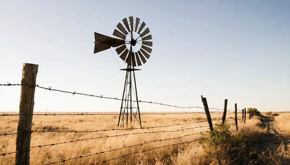
You’ll find Cryer Creek, a ghost town in Navarro County, Texas, four miles north of Barry at the intersection of FM 1126 and FM 2930. Named for a waterfall’s haunting cry, this former farming community peaked at 200 residents in 1892. Today, only a historic cemetery and old grocery store remain from William Melton’s 1854 settlement. The rich soil and rolling hills still whisper tales of pioneer life along these quiet waters.
Key Takeaways
- Cryer Creek, established in 1854, became a ghost town after being bypassed by the Texas and St. Louis Railway.
- The town’s population peaked at 200 residents in 1892 before declining to scattered dwellings by the 1930s.
- Only two structures remain today: a historic cemetery and an old grocery store building.
- Located at FM 1126 and FM 2930, four miles north of Barry, Texas.
- The closure of the post office in 1907 and decline of cotton operations accelerated the town’s abandonment.
The Origins Behind the Crying Waters
While many Texas ghost towns earned their names from founders or prominent citizens, Cryer Creek‘s origin stems from a natural phenomenon that once defined the landscape.
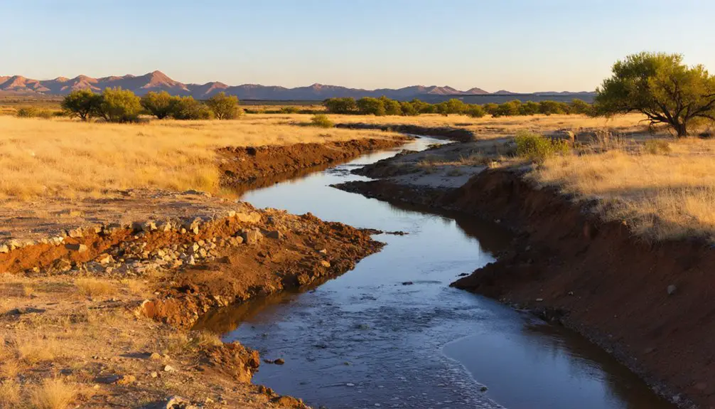
You’ll find the story in Navarro County, where early settlers discovered a remarkable waterfall that produced sounds eerily similar to a woman’s crying. This distinctive feature shaped the community’s identity, as the Crying Waters became both a practical landmark and a source of local folklore.
The creek, which still flows eastward through red soil and native grasses, eventually joins Chambers Creek. Near the creek stands the historic Grange Hall Cemetery, a testament to the area’s pioneer heritage. Today, the land includes 720 acres of working cattle ranch property.
Meandering through crimson earth and prairie grass, the enduring waters of Cryer Creek flow steadily toward their Chambers Creek destination.
Though the waterfall’s haunting sounds have long since vanished due to geological changes and shifting water tables, its legacy lives on in the settlement’s name and the stories passed down through generations.
Pioneer Settlement and William Melton’s Vision
After the creek’s distinctive sounds drew settlers to the area, William Melton established himself as Cryer Creek’s founding pioneer in 1854, laying the groundwork for what would become a vibrant frontier community.
His pioneer aspirations transformed the settlement into a hub of community resilience, attracting other settlers who shared his vision of independence and prosperity.
The settlement reached its peak when 200 residents called Cryer Creek home in 1892.
Like the nearby Masonic lodge that served as a gathering place, the community fostered strong social bonds among its residents.
You’ll find Melton’s legacy reflected in the town’s rapid development:
- Two thriving general stores opened by Dock Garlington and Wilt Stokes in 1878
- A post office established by Bud Conger in 1879, connecting the settlement to the outside world
- Three churches and a district school fostering social bonds and education
- Three steam cotton gin-gristmills powering the local economy
Life Along the Creek’s Edge
As settlers discovered the distinctive sound of falling water that gave Cryer Creek its name, they found an ideal location at the intersection of what would become Farm to Market Roads 1126 and 2930.
You’ll find that early residents quickly adapted to life along this essential water resource, establishing rural traditions that would shape the community for generations.
The creek’s reliable flow supported diverse agricultural practices, from cotton fields to grain production.
You’d have experienced mild winters and hot summers here, making spring and fall the perfect seasons for farming and outdoor activities.
The mixed woodland and farmland typical of central Texas provided settlers with the natural resources they needed, while the creek itself became the lifeblood of their agricultural endeavors.
Historical aerial maps would have shown the gradual development of these farming communities, though such imagery is not currently available for this region.
Like many Texas communities such as Red River Station, the settlement’s growth was closely tied to its water access and strategic location.
A Community Takes Shape
As you explore Cryer Creek’s early development, you’ll find William Melton’s 1854 settlement marked the beginning of this Texas farming community.
You can trace how the creek’s distinctive crying sound, created by its waterfall, gave both the town and surrounding area their memorable name.
The settlement’s agricultural focus quickly attracted more pioneers before 1855, establishing the foundations of what would become a thriving rural community at the crossroads of FM 1126 and FM 2930. The town’s prosperity peaked when it reached 200 residents in 1892. Located in Navarro County, the settlement became an important part of Texas’s rural landscape.
Early Settlement Patterns
When William Melton established the first settlement at Cryer Creek in 1854, he laid the foundation for a thriving agricultural community in mid-19th century Texas.
The settlement patterns quickly took shape as other pioneers joined him, drawn by the region’s opportunities for farming and stock-raising. After the Civil War, German and Czech immigrants arrived to establish new farms in the area.
You’ll find the early agriculture was shaped by:
- Fertile bottomland soils ideal for cotton and corn production
- Land grants and purchases dedicated to farming operations
- Development of tenant farming and sharecropping systems
- Strategic placement of steam-powered cotton gins and gristmills
Creek Shapes Town Growth
The meandering path of Cryer Creek profoundly influenced the development of this Navarro County settlement, positioned strategically near the intersection of Farm Roads 2930 and 1126.
You’ll find that early settlers made calculated settlement strategies, establishing their homes and farms near the creek’s fertile banks where water access was reliable and soil conditions were ideal.
Modern satellite maps reveal the historical patterns of settlement and agricultural development that followed the creek’s natural flow.
The creek’s ecology shaped the community’s growth pattern, with the surrounding terrain of hills and escarpments typical of the Cross Timbers region directing where people could build.
You’ll notice how the waterway served as more than just a resource – it became the backbone of the community’s infrastructure, influencing road placement and bridge construction while creating natural boundaries that defined neighborhood layouts and agricultural zones.
Natural Features and Geographic Appeal
Located between Blooming Grove and Barry in Navarro County, Cryer Creek‘s natural setting combines gently rolling hills with its namesake waterway that helped define both the settlement’s character and folklore.
The geological features and ecological significance of this east Texas landscape create an environment worth exploring.
You’ll discover a rich tapestry of natural elements that shaped the town’s development:
- A distinctive creek whose flowing waters produce sounds reminiscent of a woman crying
- Mixed prairie and woodland ecosystems supporting diverse wildlife and vegetation
- Fertile terrain that once sustained thriving cotton farms and grazing lands
- A humid subtropical climate zone offering mild winters and productive growing seasons
Today, the area’s natural charm persists alongside remnants of human settlement, offering glimpses into how the environment shaped local history.
Settling into life along the fertile plains between the Brazos and Trinity rivers, Navarro County’s earliest pioneers faced both challenges and opportunities as they established their communities in the 1830s and 1840s.
You’d find pioneer lifestyles centered around subsistence farming, with families like the McFaddens and Westbrooks working large land grants to sustain themselves.
Community governance emerged through shared spaces – log buildings served multiple purposes as schools, churches, and courthouses.
You’d gather with neighbors at church camp meetings in Bazette, where annual gatherings strengthened social bonds.
Trading posts, like George Washington Hill’s near Spring Hill, provided essential supplies and facilitated trade.
Without good roads, you’d rely heavily on local resources and fellow settlers, creating tight-knit communities bound by mutual support and survival.
The Path to Abandonment
While early settlers built strong communities through mutual support, Cryer Creek’s story would take a different turn by the late 19th century.
The town’s path to abandonment emerged through several key economic shifts and infrastructure changes that you’d recognize as fatal blows to any frontier settlement:
- The Texas and St. Louis Railway’s decision to bypass the town, cutting off essential transportation links
- Relocation of the post office to Barry in 1907, signaling a loss of institutional presence
- Decline of the once-thriving cotton gin and gristmill operations
- Migration of families to better-connected communities with stronger prospects
You’ll find that by the 1930s, what was once a bustling community of 200 had dwindled to scattered dwellings.
The abandonment factors worked quickly, transforming Cryer Creek into another Texas ghost town, with only a grocery store and cemetery remaining by century’s end.
Legacy in Local Memory
Though Cryer Creek’s buildings have largely vanished, the town’s legacy endures through rich oral traditions and physical remnants that tell its story.
While its structures may be gone, Cryer Creek’s spirit lives on through stories passed down and traces left behind.
You’ll find community memories preserved in tales of the creek’s haunting cry that gave the settlement its name, and stories of pioneers like Wm. Melton who shaped the area’s early days.
The town’s cultural significance lives on through its cemetery, documented history of the 85-student schoolhouse, and memories of Garlington and Stokes’ general store.
Local families keep these stories alive, while maps and archives from the 1960s help maintain accurate records of the town’s layout.
As part of Navarro County’s heritage, Cryer Creek continues to symbolize the broader narrative of Texas rural life, reflecting themes of progress and adaptation in the state’s ever-evolving landscape.
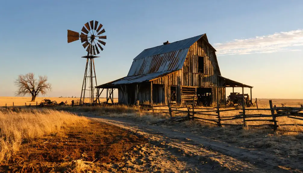
What Remains Today
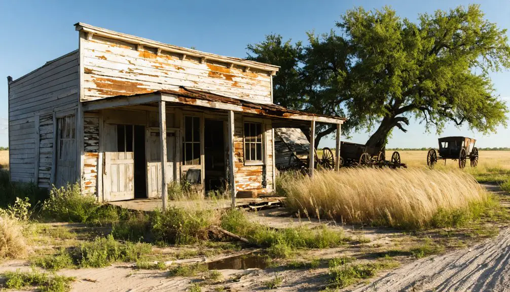
Today, you’ll find only two significant structures remaining in Cryer Creek: a historic cemetery and the old grocery store building that operated until 1962 under Minnie Garlington Walker’s management.
You can reach these remnants at the intersection of FM 1126 and FM 2930, about four miles north of Barry, Texas, via well-maintained two-wheel drive roads.
While most of the town’s original buildings have vanished, including the three churches and district school that once served 85 students, these surviving landmarks help mark the location of this former community.
Physical Structures and Ruins
Despite decades of abandonment, several physical remnants of Cryer Creek’s past still dot the Texas landscape.
Today, you’ll find the old cemetery standing as the most well-preserved evidence of the town’s history, with its scattered but intact tombstones providing vital records of early settlers.
The dilapidated general store‘s foundation and partial walls offer insight into the structural significance of 19th-century rural Texas architecture.
- Cemetery remains the primary visible landmark, featuring well-preserved grave markers
- Former general store ruins maintain partial walls and foundation
- Scattered residential foundations hint at former dwelling locations
- Natural springs and creek continue to define the settlement’s original footprint
While most structures have succumbed to time, these ruins preserve fragments of Cryer Creek’s story, though vegetation increasingly reclaims the historic townsite.
Site Access Information
Located in Navarro County, Texas, Cryer Creek’s ghost town site presents unique access challenges for modern visitors.
You’ll need to navigate rural roads without formal signage, so bring GPS coordinates or historical maps to find the location. Before exploring, verify access rights since much of the surrounding land is privately owned.
You won’t find maintained trails or visitor facilities here, so you’re responsible for your own visitor safety while traversing the uneven terrain.
The site’s accessibility varies with weather conditions – rain can make the ground muddy and difficult to navigate. Since there’s no designated parking or marked entrance, you’ll need to plan your approach carefully and be prepared for off-trail exploration.
Remember that removing artifacts or disturbing the site may violate local laws.
Mapping Historical Locations
When mapping Cryer Creek‘s remaining historical locations, you’ll find the old grocery store from 1878 stands as the most prominent surviving structure amid scattered building remnants.
The ghost town‘s layout centers near the intersection of FM 1126 and 2930, four miles north of Barry, Texas.
exploring dye mound ghost town reveals remnants of its vibrant past, with crumbling structures and overgrown pathways that hint at former inhabitants. Visitors are often captivated by the stories that linger in the air, as well as the haunting beauty of the Texas countryside surrounding this forgotten place. Each step through the town feels like stepping back in time, inviting adventurers to uncover its hidden history.
For historical mapping purposes, key reference points include:
- Cryer Creek Cemetery, the most intact site featuring weathered but identifiable grave markers
- The namesake creek that defines the settlement’s natural boundaries
- Former post office location (closed 1907) marked by historical documentation
- Original road patterns that align with current access tracks
The surrounding agricultural land frames what was once a bustling community, though most structures have succumbed to time, leaving only foundations and rubble as evidence of their existence.
Exploring Historical Footprints
Through careful exploration of Cryer Creek‘s remaining physical evidence, you’ll find a settlement that once thrived at the intersection of FM 1126 and FM 2930.
Today, you can trace the town’s historical significance through its cemetery and a single surviving building that once served as a grocery store, standing as silent witnesses to the community’s cultural heritage.
When you visit, you’ll discover how this former hub of 200 residents supported three churches, multiple stores, and three steam cotton gin-gristmills by 1884.
While most structures have vanished, the site’s scattered remains tell the story of a once-bustling agricultural community.
The town’s gradual decline began when the Texas and St. Louis Railway bypassed it, leading to its eventual transformation into the quiet rural landscape you see today.
Frequently Asked Questions
What Major Diseases or Epidemics Affected Cryer Creek’s Population?
You won’t find documented disease outbreaks specific to Cryer Creek, though common health impacts of the era likely included cholera, tuberculosis, influenza, and smallpox affecting its rural population.
Were There Any Native American Settlements Near Cryer Creek Before 1845?
You’ll find evidence of Native American tribes like Tonkawa and Comanche near Brushy Creek and San Gabriel River before 1845, with historical artifacts confirming their settlements around what became Cryer Creek.
Did Cryer Creek Have a School, Church, or Post Office?
Want to know about Cryer Creek’s community life? You’ll find they had a thriving district school with 85 students, three churches by 1884, and a post office that operated until it moved to Barry in 1907.
What Crops Were Primarily Grown by the Settlers of Cryer Creek?
You’ll find the settlers primarily focused on cotton farming and corn production, while also growing wheat, barley, and sorghum. They’d plant peaches and plums in their orchards for local consumption.
Were There Any Notable Conflicts or Violence in Cryer Creek’s History?
Despite searching through a mountain of historical records, you won’t find any documented conflicts or violence in Cryer Creek’s history. The town’s decline was purely economic, linked to being bypassed by railways.
References
- https://www.ghosttowns.com/states/tx/tx_ghst_twns_sect1345.doc
- https://www.ghosttowns.com/states/tx/cryercreek.html
- https://en.wikipedia.org/wiki/List_of_ghost_towns_in_Texas
- https://pastmaps.com/explore/us/texas/ellis-county/rankin/hiking-exploration
- https://texashistory.unt.edu/explore/locations/p05889/
- https://www.texasescapes.com/TOWNS/Texas-Ghost-Towns-2-Central-Texas.htm
- https://www.texasescapes.com/CentralTexasTownsNorth/Cryer-Creek-Texas.htm
- https://txnavarr.genealogyvillage.com/cemetery/grange_hall/grange_hall_cemetery_history.htm
- https://www.pinecove.com/blog/the-history-of-pine-cove-in-central-texas/
- https://texashighways.com/culture/history/taking-the-waters-the-fascinating-history-of-texas-mineral-water-resorts/


