Dana, Massachusetts was a thriving New England town established in 1801 that met a dramatic end in 1938 when it was submerged beneath the Quabbin Reservoir. You’ll find its remains along the northeastern Swift River Valley, where stone walls and foundations tell stories of a close-knit farming community that once housed 876 residents. Today, you can explore Dana Common, listed on the National Register of Historic Places, where five roads converged at the town’s heart. The waters hold countless more untold tales of this lost community.
Key Takeaways
- Dana was a thriving Massachusetts town established in 1801 that was disincorporated and submerged beneath the Quabbin Reservoir in 1938.
- The town’s 876 peak residents were forced to evacuate after the 1927 Massachusetts Legislature decision to create the reservoir.
- Stone walls, foundations, and cellar holes remain visible today at Dana Common, which is listed on National Register of Historic Places.
- The site can be accessed through Gate 40 in Petersham, with best viewing during spring through early fall.
- Extensive documentation including photos, interviews, and memorial markers preserve the town’s history from 1801-1938.
The Rise of a Rural New England Town
When Massachusetts formally established Dana in 1801 from parts of Greenwich, Hardwick, and Petersham, the town’s strategic location in the northeastern Swift River Valley positioned it for steady growth.
You’d have found Dana Common at the heart of the community, where five roads converged to connect major neighboring towns. The Swift River’s reliable water power drove the town’s development, enabling sawmills, gristmills, and textile operations to flourish alongside agriculture.
Five roads met at Dana Common, creating a bustling hub where water-powered mills drove the town’s industrial and agricultural growth.
Dana’s population peaked between 1860-1870 with nearly 900 residents, supported by diverse economic activities. You could’ve found everything from palm-leaf hat weaving to soapstone quarrying. The Swift River Box Company contributed significantly to the town’s manufacturing sector.
While the 1873 railroad arrival in North Dana shifted growth away from the Common, marking the beginning of the town center’s economic decline, Dana remained a reflection of New England’s rural industrialization. The town’s fate was sealed when officials chose the Swift River Valley for the Quabbin Reservoir due to its minimal industrial development.
Life in Dana Before the Reservoir
If you’d lived in Dana during the 1920s-30s, you’d have found yourself part of a close-knit farming community where daily life centered around agricultural work and small-scale manufacturing at local mills.
You might’ve attended services at the church on Dana Common or sent your children to the town’s school, which operated until its final graduation in 1938.
Your shopping needs would’ve been met in North Dana’s business district, where local merchants served both town residents and travelers passing through the Swift River Valley. The town enjoyed convenient transport and trade opportunities thanks to its access to railroad connections. The community’s population reached its highest point of 876 in 1860 before gradually declining in subsequent decades.
Daily Activities and Commerce
During its peak years between 1840-1870, Dana thrived as a bustling manufacturing and commercial center anchored by its triangular Common. Local businesses, including Cotton General Store and Eagle Hotel, clustered around this central hub, serving both residents and travelers.
You’d find a vibrant mix of trade routes connecting Dana’s manufacturers to external markets via the railroad. The town’s impressive advancement was evident in their acquisition of a motorized fire truck.
Manufacturing drove the town’s prosperity, with water-powered operations producing boxes, straw hats, cloth, and soapstone items. As the first town in Swift River Valley with electricity, Dana’s industrial capabilities expanded greatly.
The population swelled to 876 by 1860, reflecting the town’s economic vitality. Farmers worked the cleared fields marked by stone walls, while orchards dotted the landscape, contributing to Dana’s diverse commercial activity. Today, only stone foundations remain to mark where these vibrant businesses once stood.
Church and School Life
Religious and educational institutions formed the bedrock of Dana’s social fabric, centered around its iconic Common.
You’d find the prominent Congregational Church and Baptist meetinghouse hosting regular worship services, with church gatherings serving as essential community touchstones. These sacred spaces doubled as venues for civic meetings and social events. The town’s vibrant community life came to an abrupt end when Dana was forcibly evacuated in the 1930s.
The Center School, a two-story building on Dana Common, educated local children through eighth grade. Before its dissolution, the town was a major producer of palm-leaf hats that were sold worldwide.
You’d see younger students studying downstairs while older pupils learned upstairs, with 33 students enrolled by 1931.
If you wanted to attend high school, you’d need to travel to Orange or Athol at your own expense. Many students instead chose to work in local factories or farms after completing their eighth-grade education, reflecting the economic realities of rural New England life.
The Decision That Changed Everything
When the Massachusetts Legislature made the momentous decision to impound Swift River in 1927, they effectively sealed Dana’s fate. The legislative impact sent shockwaves through the community as residents learned their homes would be taken by eminent domain to create Boston’s water supply.
The community response unfolded in four devastating phases:
- You’d witness your neighbors receiving official notices from the Metropolitan District Water Supply Commission.
- You’d watch as surveyors mapped and photographed every building in town.
- You’d see fellow residents accepting compensation of $108 per acre for their land.
- You’d experience the heartbreak of the final town meeting in March 1938.
Today, the area remains a protected site with strict regulations on permissible activities. The former town of Dana now rests beneath the Quabbin Reservoir, which was completed in 1939.
Documenting a Town’s Final Days
As Dana’s residents faced their final days in town, state officials launched a thorough effort to document every aspect of the community before it disappeared forever.
You’ll find evidence of their meticulous work in the systematic mapping, photography, and cataloging of every building. During the town’s final days, teams carefully recorded the locations of stone foundations, property boundaries, and road alignments that would soon be transformed.
The process of town disincorporation reached its climax with the last town meeting in March 1938.
The Great Displacement

Long before the final evacuation notices arrived in 1938, the Swift River Valley‘s fate had been sealed through calculated legislative actions spanning decades.
The historical significance of this forced displacement can’t be understated, as 2,500 residents faced an impossible reality: abandon their homes or face state intervention.
Faced with state intervention, 2,500 Massachusetts residents confronted a stark choice: leave their generational homes or be forcibly removed.
The community impact manifested in four devastating ways:
- Families who’d farmed the land for generations received just $108 per acre.
- Thirteen cemeteries were exhumed, severing ancestral connections.
- Four towns – Dana, Enfield, Greenwich, and Prescott – were legally erased overnight.
- Surrounding communities lost significant portions of their land.
While residents mounted resistance, their lack of resources and political power left them powerless against Boston’s water demands.
What Remains Above the Waters
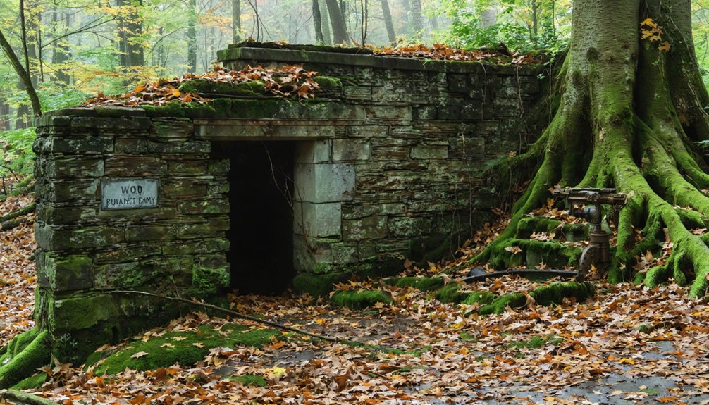
If you visit Dana Common today, you’ll find stone walls, cellar holes, and foundations telling the poignant story of this displaced community.
The triangular town common, listed on the National Register of Historic Places, features a stone memorial marker commemorating the town’s residents from 1801 to 1938, alongside visible fragments of original landscaping like stone steps and paved remnants.
From this preserved nucleus, you can explore an array of surviving features including the Center School’s cellar hole, granite steps, and stone fence posts that outline the ghost town’s former streets and property boundaries.
Stone Walls Still Stand
The stone walls of Dana still stand as silent sentinels, marking where this lost town once thrived before the Quabbin Reservoir claimed it in 1938.
You’ll find these remarkable examples of stone craftsmanship throughout the 68-acre town center, now listed on the National Register of Historic Places for its historical significance.
As you explore Dana’s remains, you’ll discover:
- Moss-covered boundary walls that trace former property lines and encircle abandoned fields
- An intact retaining wall at the Edger Vaughn residence, built with stream-smoothed stones
- Rock-lined cellar holes surrounding Dana Common, dating from 1840-1855
- Stone foundations marking the former poor farm, Town Hall, and other essential structures
These enduring walls tell the story of a community’s craftsmanship, preserving Dana’s memory above the waters.
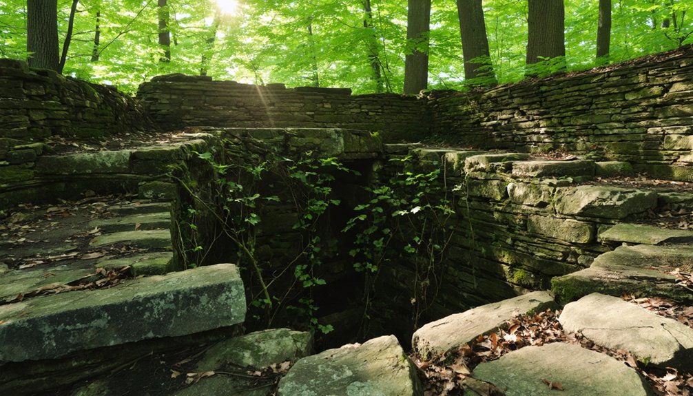
Foundations Tell Their Tales
Beneath the surface of Dana Common, stone foundations and cellar holes reveal the ghostly footprints of a once-thriving community.
You’ll find multiple depressions marked by exposed stonework and rubble, surviving the 1938-1940 razing efforts when the town was disincorporated.
The foundation significance lies in their varied architectural styles – from laid fieldstone to mortared granite steps – which showcase typical 19th-century building practices from Dana’s peak growth period of 1840-1855.
You can spot the Center School’s cellar remains, where 33 students studied in 1931, providing a dated reference point for other building locations.
These foundations, deliberately preserved when structures were relocated, align perfectly with old roadbeds and the triangular town common plan, letting you piece together Dana’s historical layout from both visible remains and archived maps.
Dana Common Lives On
While many foundations tell Dana’s story from below, its common area remains a tribute to life above ground, perched strategically on high terrain beyond Quabbin Reservoir’s waterline.
As a reflection of community resilience, you’ll find carefully preserved remnants that paint a picture of this once-vibrant town center.
Historical preservation efforts highlight Dana Common‘s significance through:
- Stone walls marking former property boundaries, including the distinctive Vaughns’ stream-sourced barrier
- Granite steps and foundation stones from the 1840-1855 buildings that once framed the triangular common
- Traces of old orchards and cleared fields that sustained local families
- A commemorative plaque maintained by Massachusetts DCR, honoring the town’s legacy until its 1938 disincorporation
Preserving Dana’s Legacy
Following Dana’s submergence beneath the Quabbin Reservoir in 1938, extensive preservation efforts have guaranteed that this lost town remains one of New England’s most thoroughly documented communities.
You’ll find thousands of catalogued photos, 150 digitized interviews, and carefully mapped remnants that tell Dana’s story. The Massachusetts Department of Conservation and Recreation maintains the site’s historical significance through interpretive services and protected access via Gate 40 in Petersham.
At Dana Common, you can explore stone foundations, cellar holes, and granite steps while viewing placards that match historic photographs to present-day locations.
The 1996 Dana Reunion memorial plaque and preserved structures like the Vaughn wall and George Carter Poor Farm basement stand as symbols of the community’s enduring spirit and sacrifice.
Exploring the Ghost Town Today
Today’s visitors to Dana can explore this historic ghost town through carefully managed access points in the Quabbin Reservoir watershed.
Urban exploration enthusiasts will discover a landscape rich with historical preservation efforts, featuring cellar holes, granite steps, and stone walls that tell the story of this lost community.
For the most rewarding ghost town experience:
- Park at designated trailheads like Gilbert Road or Dana Common access points and prepare for a 1-3 mile walk
- Visit during spring through early fall when stone remains are most visible
- Bring DCR Quabbin trail maps to locate hidden cellar holes and former road alignments
- Photograph the site during early morning or late afternoon for dramatic lighting of stone features
Remember that while exploring, you’ll need to follow DCR watershed regulations – no camping, fires, or restricted area access permitted.
Stories From the Lost Valley
As residents prepared to leave their homes in 1938, the story of Dana’s lost valley became etched into New England history through personal accounts and official records.
You’ll find forgotten memories of a thriving community that once boasted 876 residents at its peak, with modern amenities like electricity and the valley’s only motorized fire truck.
The lost stories of Dana paint a picture of New England civic life centered around its town common, where a town hall, post office, church, and Civil War memorials once stood.
Dana’s town common embodied classic New England life, anchored by civic pillars that fostered community until the waters claimed it forever.
In their final months, residents watched as state officials cataloged their properties, paying $108 per acre, while 124 graves were carefully relocated and buildings were either moved or razed before the waters rose.
Frequently Asked Questions
Did Any Residents Refuse to Leave Dana During the Evacuation?
You won’t find evacuation stories of resident resistance in Dana – historical records show no documented cases of residents refusing to leave, though nearby Enfield saw Marion Andrews Smith’s notable defiance.
What Happened to Dana’s Pets and Livestock During the Town’s Displacement?
You won’t find official records about pet relocation or livestock welfare in Dana’s displacement. While residents likely took their animals when possible, history’s silent on their ultimate fate.
How Much Did Residents Receive as Compensation for Their Properties?
While exact compensation amounts weren’t well-documented, you’d have received fair-market value for your property, though many residents disputed these payments as inadequate for losing their generational homes and livelihoods.
Were There Any Archaeological Discoveries Made During the Town’s Demolition?
While you’ll find historical artifacts in cellar holes and foundations, there’s limited documentation of specific archaeological findings during demolition, as the focus was on quickly clearing land for the reservoir.
Do Any Former Dana Residents or Their Descendants Still Visit Today?
You’ll find no official records of former residents or descendants visiting Dana today, though it’s likely that families, like those who once lived along Greenwich-Dana Road, quietly return to remember.
References
- https://www.youtube.com/watch?v=SWTpnPi-CS8
- https://www.oddthingsiveseen.com/2013/09/high-and-dry-and-dearly-departed-ghost.html
- https://wbsm.com/massachusetts-town-dana-hiking-trail/
- https://www.youtube.com/watch?v=NrBWmYUnqPM
- http://www.skinut.net/dana.htm
- https://www.atlasobscura.com/places/town-of-dana
- https://www.digitalcommonwealth.org/collections/commonwealth-oai:c247g393x
- https://www.outoftheoffice4good.com/post/hiking-to-the-abandoned-town-of-dana-massachusetts
- http://findingaids.library.umass.edu/ead/mums012
- https://www.nps.gov/places/dana-common.htm


