Across America, hundreds of towns lie submerged beneath reservoirs and artificial lakes. You’ll find California’s Sunken City of San Pedro, Appalachian settlements under TVA dams, and Texas communities like Old Bluffton that reappear during droughts. These underwater time capsules were sacrificed for dam projects and water management initiatives throughout the 19th-20th centuries. The stories of displaced communities and their occasional reemergence reveal the complex intersection of progress, preservation, and forgotten histories.
Key Takeaways
- California has the highest concentration of submerged settlements in the US, with notable examples like San Pedro’s Sunken City and Alma.
- Appalachian Mountains contain numerous towns submerged by TVA dam projects, with foundations and graves emerging during drawdowns.
- Texas features several underwater ghost towns including Old Bluffton and Preston, which become visible during severe drought conditions.
- New Deal dam projects prioritized infrastructure over preservation, displacing communities like St. Thomas and indigenous populations without adequate compensation.
- Drought conditions create temporary archaeological windows, exposing structural foundations, cemetery markers, and artifacts that reveal America’s architectural history.
The California Coast: America’s Most Submerged State

California’s coastal region holds the dubious distinction of containing America’s highest concentration of submerged settlements, earning it the title of the nation’s most inundated state.
You’ll find prime examples in San Pedro’s Sunken City, where geological instability caused a neighborhood to collapse into the Pacific between 1929-1940s. After initial water line damage, land subsidence reached 11 inches daily, eventually claiming 40,000 square feet of terrain. Today, an iron fence installed in 1987 attempts to deter trespassers, though many still risk the dangerous site.
The Lexington Reservoir deliberately submerged Alma in 1952, following the dam construction announced in 1947. Residents held a “funeral” for their town before evacuation.
Coastal erosion and environmental factors doomed Bombay Beach, with Hurricane Kathleen in 1976 raising water levels by 8 feet in just 3 hours.
In just 3 hours, Hurricane Kathleen transformed Bombay Beach forever, raising water levels by 8 feet and sealing its environmental fate.
Throughout California, these submerged settlements resulted from natural disasters, mining depletion, water access issues, and infrastructure projects. Similar to these lost towns, Parisa faced devastating effects when a major flood in 1862 severely impacted the township’s long-term viability.
Appalachian Valleys: Towns Beneath Mountain Lakes
While California’s coastline grapples with encroaching waters, the eastern United States harbors its own aquatic ghost towns in the verdant Appalachian Mountains.
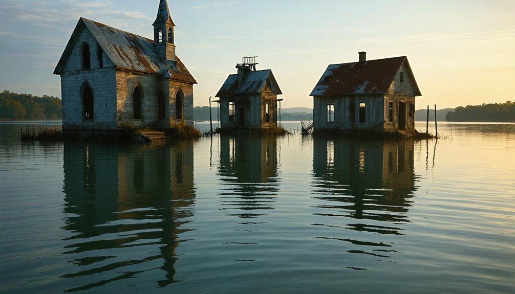
Beneath Fontana, Tellico, Calderwood, Norris, and Smith Mountain lakes lies a submerged history of forced displacement. These artificial reservoirs, created by TVA dams in the mid-20th century, entombed entire communities—Judson, Proctor, Loyston, Butler, and ancient Cherokee settlements including Chota and Tanasi.
Your lost heritage rests in these depths: foundations emerge during drawdowns, revealing the remnants of burned homesteads and relocated graves. The “Loyston Sea” exemplifies how government hydroelectric projects prioritized industrial needs over generational lands. During winter months, Summersville Lake’s receding waters expose old roadways and foundations of the forgotten village of Gad.
Butler, once a thriving community with schools, churches, and 50 businesses, was relocated in 1948 when the Watauga Dam project submerged the original town.
When you boat across these mountain lakes today, you’re traversing submerged histories of resistance, indigenous cultural sites, and Appalachian communities sacrificed for wartime power and progress.
Texas Ghost Towns: Lone Star Submersions
Throughout the Lone Star State, beneath seemingly tranquil reservoir waters, lies a submerged chapter of Texas history that mirrors the aquatic fate of Appalachian communities.
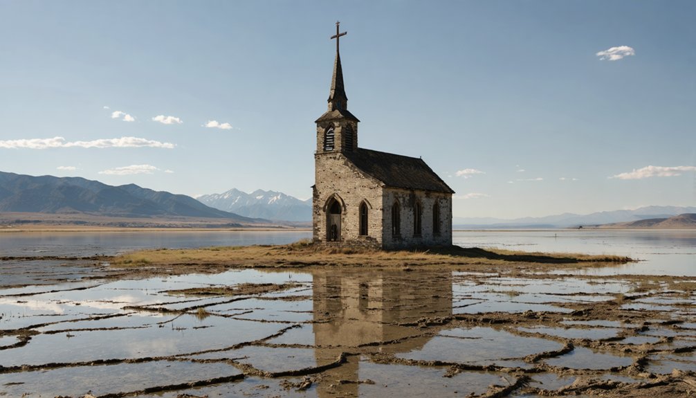
You’ll find Old Bluffton entombed under Lake Buchanan since 1937, occasionally revealing its structural skeletons during severe droughts. The town was originally home to fifty farming families whose livelihoods depended on the fertile land for growing pecans and corn.
Lake Texoma claimed multiple settlements in 1944—Preston, Hagerman, and Cedar Mills—communities sacrificed for water management. Preston once thrived as a crossing point for the Butterfield Stage Lines and the Shawnee cattle trail. When reservoir levels drop, you glimpse tombstones and foundations of these once-vibrant Texas towns.
Toledo Bend Reservoir conceals Robinson Bend, a mainly Black settlement whose descendants still honor their submerged heritage.
Similarly, Swartwout—an 1838 Trinity River settlement—vanished beneath engineered waterways.
These submerged histories represent a recurring pattern: communities relinquished to infrastructure demands, their existence preserved primarily through documentation and drought-exposed artifacts.
New Deal Dam Projects: Communities Sacrificed for Progress
During the New Deal era, Franklin Delano Roosevelt’s administration fundamentally altered America’s landscape through an unprecedented program of dam construction that prioritized national infrastructure over local community preservation.
You’ll find these massive engineering feats transformed rivers while submerging entire communities—an infrastructure sacrifice deemed necessary for national progress.
- St. Thomas, Nevada vanished beneath Lake Mead in 1938, illustrating federal policy’s disregard for established communities.
- Winnemem Wintu tribe lost ancestral lands to Shasta Dam without proper compensation or consent.
- Grand Coulee Dam delivered promised economic benefits while permanently altering the Columbia River ecosystem.
- Rural towns bore disproportionate costs while urban centers received flood control benefits.
- Community displacement occurred without environmental or cultural impact assessments now considered standard.
The Corps of Engineers initially recommended relocating homes away from flood zones, but policy shifted toward controlling nature rather than adapting to it—a philosophy that would reshape America’s waterways permanently. While iconic structures like the Hoover Dam were completed ahead of schedule and under budget, their human costs were rarely calculated in the final accounting. These policies emerged in response to historical precedents like the Johnstown flood of 1889, which demonstrated the catastrophic potential of unmanaged water systems.
Drought Revelations: When History Resurfaces
You’ll find drought-exposed ruins offering fleeting glimpses into America’s submerged past when reservoir levels plummet during extended dry periods.
These temporary archaeological windows expose building foundations, roadways, gravestones, and artifacts from towns like Preston Bend and Detroit, which were sacrificed for water management infrastructure.
The cyclical nature of these revelations creates recurring opportunities for historians and descendants to document and connect with communities that would otherwise remain hidden beneath the water’s surface. Towns like Proctor, Andersonville, and Loyston represent significant examples of lost cultural heritage due to government-sponsored dam projects throughout the 20th century. In 1983, Butler, Tennessee experienced this phenomenon when maintenance activities revealed remarkably preserved structures including a shoe shop and jailhouse after decades underwater.
Drought-Exposed Historical Treasures
When severe drought conditions grip America’s reservoirs, the receding waters disclose a peculiar historical phenomenon: the ghostly remnants of towns deliberately submerged decades ago.
These drought impacts disclose historical artifacts from communities sacrificed for infrastructure projects in the 20th century—places like St. Thomas, Nevada and Old Kernville, California resurfacing after 2002’s water recession.
- Structural foundations and building ruins emerge as tangible connections to pre-reservoir settlements.
- Cemetery markers and relocated gravesites tell stories of displaced communities.
- Infrastructure remnants like railway beds and road foundations reveal transportation networks.
- Personal artifacts provide archaeological insights into frontier lifestyles.
- Visible town layouts demonstrate urban planning from America’s developmental era.
These drought-exposed treasures offer rare glimpses into American settlement patterns, providing unrestricted access to history normally concealed beneath reservoir waters—fleeting windows into our past before rising waters reclaim them.
Recurring Archaeological Windows
Droughts reveal more than just structural foundations—they create temporal portals into America’s architectural evolution through window artifacts. When receding waters expose colonial sites, you’ll discover archaeological windows providing precise chronological anchors through their distinctive features.
You can identify manufacturing periods by examining crown glass thickness variations—thicker at centers, thinner at edges—while the diamond and rectangular panes tell stories of regional construction preferences. The lead soldering angles and craftsman marks you’ll uncover serve as temporal fingerprints, with approximately 10% bearing maker inscriptions that establish terminus post quem dating.
Conservation efforts have unveiled hundreds of marked window leads from Anne Arundel sites, where glass artifacts demonstrate remarkable temporal accuracy—often matching occupancy shifts precisely or preceding them by mere months, offering you unparalleled insights into America’s submerged architectural heritage.
Preserving the Submerged Past: Archaeological Challenges
Archaeological work at drought-exposed reservoir sites presents a time-critical opportunity to document historical structures before they’re submerged again, forcing researchers to choose between quick salvage operations and more thorough recording methods.
You’ll encounter significant technical challenges when attempting to preserve artifacts from these environments, as fluctuating water levels accelerate deterioration through repeated wet-dry cycles that compromise structural integrity and organic materials.
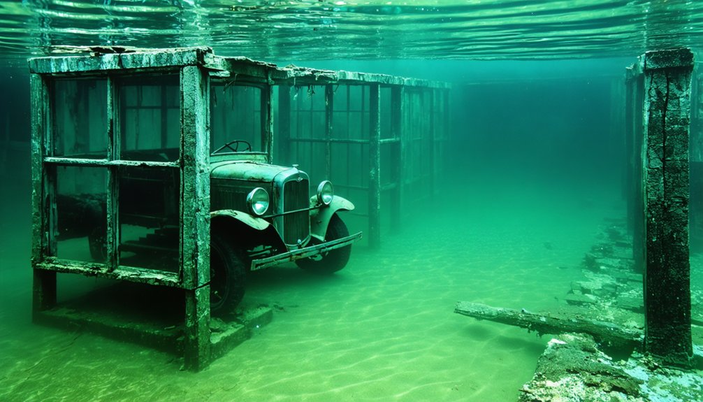
Specialized underwater documentation techniques—including photogrammetry, side-scan sonar, and remote sensing technologies—have become essential tools for creating detailed records of submerged cultural landscapes that would otherwise remain inaccessible to traditional archaeological approaches.
Drought-Exposed Historical Treasures
As reservoir levels recede during severe drought conditions, a hidden archaeological timeline emerges from beneath the water’s surface, presenting both unprecedented research opportunities and complex preservation challenges.
These drought impacts reveal entire town layouts, offering you fleeting windows into America’s submerged historical significance before waters inevitably return.
- Complete building foundations, street grids, and infrastructure become temporarily visible, allowing for thorough mapping.
- Archaeologists can verify historical records against physical evidence during these rare exposure events.
- Legible headstones from submerged cemeteries provide genealogical data otherwise inaccessible.
- Time-sensitive documentation must occur rapidly as exposure periods remain unpredictable.
- Citizen scientists contribute valuable photographic evidence while creating preservation concerns through increased site traffic.
You’re witnessing a paradoxical phenomenon—drought destruction simultaneously enabling historical rediscovery of communities once deliberately sacrificed for water management.
Salvage Versus Submersion
Nearly every submerged settlement presents archaeologists with a fundamental dilemma: whether to extract artifacts during temporary exposure periods or leave them in situ to maintain contextual integrity.
When water levels drop, you’ll witness remarkable preservation conditions that challenge conventional recovery methodologies.
The Atlas of Drowned Towns project demonstrates how systematic documentation can counterbalance submersion impacts through digital archiving.
Evidence from St. Thomas, Nevada reveals how underwater environments paradoxically preserve certain structural elements while accelerating decay in others.
Meanwhile, salvage operations must navigate the ethical boundaries of community collaboration, as seen in the Ashokan Reservoir region where 466 buildings were documented within condemned “take lines.”
You’re observing a methodological revolution as interactive mapping technologies make these vanished communities accessible despite their physical inaccessibility, balancing preservation imperatives against the reality of permanent inundation.
Underwater Documentation Techniques
While water levels conceal these ghost towns beneath reservoirs and lakes, archaeologists employ sophisticated documentation techniques to preserve their cultural significance.
You’ll find that modern underwater archaeological methods combine traditional mapping with cutting-edge technology to create thorough records of these submerged settlements.
- Side-scan sonar and multibeam echosounders generate detailed seafloor images by transmitting sound waves that reveal hidden structures
- Underwater photography combined with photogrammetry creates precise 3D modeling of artifacts and architectural features
- GIS integration allows for spatial analysis and management of all documented site data
- ROVs and AUVs enable access to hazardous areas while collecting high-resolution imagery
- Conservation strategies include in situ documentation of immovable structures alongside careful artifact recovery and stabilization
Life After Displacement: The Human Story of Flooded Towns
The submersion of once-vibrant communities beneath reservoir waters represents one of the most profound disruptions to American small-town life in the 20th century.
Many of these forgotten towns along the Mississippi River were rich in culture and history, filled with families who cherished their roots. As the waters rose, the stories of these once-thriving communities began to fade, leaving behind only memories and artifacts that tell tales of resilience and sacrifice. Today, the remnants serve as a stark reminder of the past and the importance of preserving our heritage.
You’ll find the human cost staggering: 325 families displaced at Fort Berthold, 2,500 residents removed for Quabbin Reservoir, and countless others forcibly relocated from towns like Preston and Woodville.
Beyond statistics lies the erasure of cultural identity—Celilo Falls’ submersion devastated indigenous fishing traditions, while communities like Robinson Bend saw tight-knit social structures dissolved.
Relocated populations established places like New Town and New Butler, demonstrating community resilience despite inadequate compensation for their losses.
The grief of leaving behind family cemeteries, ancestral lands, and economic foundations created psychological wounds that persist generations later, even as new economic paradigms emerged around casinos and tourism.
Frequently Asked Questions
Can You Legally Dive to Explore Submerged Towns?
Like birds maneuvering guarded skies, you’re bound by legal regulations when exploring underwater towns. You’ll need proper diving permits through certified operators at sites like Jocassee Lake where technical diving’s officially sanctioned.
How Do Residents Commemorate Their Lost Underwater Communities Today?
You’ll find former residents hosting community gatherings, annual memorial events, storytelling sessions, museum exhibitions, oral history documentation, and periodic reunions—all strategically preserving cultural connections to ancestral lands now beneath reservoir waters.
What Items Were Commonly Left Behind During Hasty Relocations?
You’d find heavy furniture, agricultural equipment, historical artifacts, and personal mementos abandoned during relocations. Household foundations, pianos, and farming implements became underwater archaeological treasures when evacuation deadlines couldn’t accommodate full removals.
Are Any Submerged Towns Protected as Underwater Historical Sites?
Yes, Port Royal, Jamaica enjoys protected status as a National Heritage Site. You’ll find submerged regulations protecting numerous underwater settlements based on their historical significance, preserving these subaquatic time capsules for posterity.
How Does Water Submersion Affect Artifact Preservation Compared to Land Exposure?
You’ll find water slows artifact degradation considerably compared to land exposure. Underwater archaeology reveals organics persist longer in anaerobic environments, while metals corrode faster unless protected by stable patinas.
References
- https://kids.kiddle.co/List_of_flooded_towns_in_the_United_States
- https://www.thewanderingappalachian.com/post/the-underwater-towns-of-appalachia
- https://www.atlasobscura.com/places/old-bluffton-underwater-ghost-town
- https://cedarbayoumarina.com/four-ghost-towns-under-lake-texoma/
- https://www.youtube.com/watch?v=E0mfoxW3XIs
- https://www.neh.gov/article/atlas-drowned-towns
- https://en.wikipedia.org/wiki/List_of_flooded_towns_in_the_United_States
- https://www.islands.com/1914374/called-modern-atlantis-southern-california-secret-sunken-city-fell-ocean-abandoned/
- https://www.youtube.com/watch?v=bz6XtozCSMg
- https://www.sfgate.com/obscuresf/article/brief-history-of-a-Bay-Area-ghost-town-17397657.php