America’s creepiest ghost towns await your exploration, from Bodie’s notorious saloons to Centralia’s apocalyptic burning landscape. Walk through Bannack where a murderous sheriff met vigilante justice, witness Cahaba’s mysterious orbs dancing among Civil War ruins, or explore Ruby’s blood-soaked mercantile. Each abandoned settlement tells a unique story of violence, disaster, or economic collapse. These time capsules of America’s darker history stand frozen, their weathered buildings whispering secrets of the past.
Key Takeaways
- Bodie, California maintains 110 buildings in “arrested decay,” filled with abandoned treasures from its violent gold rush past.
- Bannack, Montana preserves 50 structures where Sheriff Plummer led a murderous gang before facing vigilante justice in 1864.
- Cahaba, Alabama features crumbling ruins of the former state capital, with reported ghostly orbs appearing after sunset.
- Centralia, Pennsylvania’s underground fire has burned since 1962, creating an apocalyptic landscape of toxic fumes and heat-warped roads.
- Ruby, Arizona earned its reputation as the “bloodiest ghost town” with infamous double homicides and whispers of supernatural phenomena.
Bodie, California: Where the Gold Rush Left Only Ghosts Behind

As you wind along the remote Sierra Nevada mountain roads toward Bodie, you’ll discover a perfectly preserved slice of America’s wild past frozen in time.
Standing at 8,379 feet elevation, this notorious boomtown once housed 10,000 gold-hungry souls before plunging into abandonment.
The ghost town legends of Bodie are legendary—where the phrase “bad man from Bodie” wasn’t just talk. With 65 saloons and nightly violence, the town earned a reputation that prompted one child’s diary entry: “Goodbye God, I’m going to Bodie.”
Danger lingered in every Bodie corner—a place so notoriously wicked even children knew they were entering godless territory.
Today, you can wander among 110 buildings maintained in “arrested decay,” filled with abandoned treasures exactly as residents left them. The California Department of Parks and Recreation has carefully preserved the site while maintaining its authentic abandoned appearance. If you’re searching for specific information about Bodie, you might need to navigate through multiple meanings associated with the name.
Personal possessions still gather dust on shelves, creating an eerie time capsule of the gold rush era when $38 million in precious metals flowed from these hills.
Bannack, Montana: The Lawless Frontier Town Frozen in Time
Deep in Montana’s rugged frontier landscape stands Bannack, a gold rush ghost town where the thin line between law and lawlessness completely dissolved in the 1860s.
Founded after a massive gold discovery in 1862, this boom town quickly amassed 5,000 souls before plunging into chaos.
You’ll walk the same streets where Sheriff Henry Plummer—secretly leading a murderous gang—met his end at vigilante hands in 1864.
This deadly form of frontier lawless justice claimed over 20 lives in America’s bloodiest vigilante episode.
As you explore over 50 preserved structures, listen for Dorothy Dunn’s ghostly footsteps in Hotel Meade.
This drowned child, often spotted in her blue dress, is just one of 60+ documented ghostly encounters.
Unexplained shadow figures have been repeatedly photographed in the historic Chrismans’ Store, believed to be connected to Plummer’s gang.
The gold found in Grasshopper Creek was incredibly pure at 99-99.5% purity, explaining the rapid influx of fortune seekers to this remote location.
Unlike tourist reproductions, Bannack remains authentically frozen in time—where 1800s spirits continue their daily lives.
Cahaba, Alabama: From State Capital to Spectral Ruins
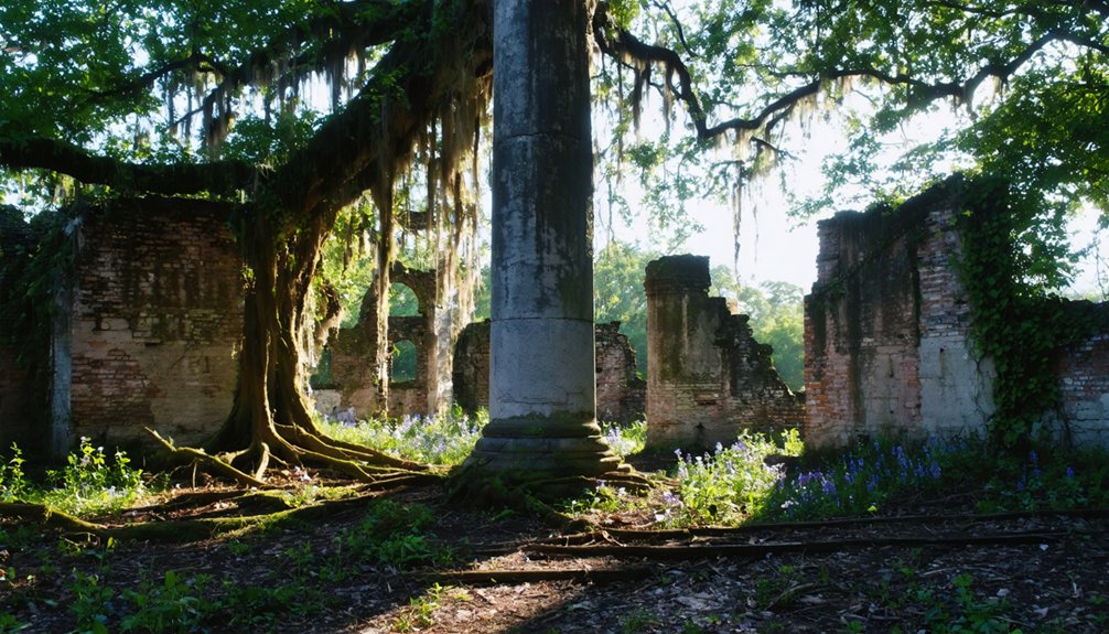
You’ll find Alabama’s first state capital abandoned beneath the murky waters that frequently flooded its streets, ultimately contributing to its demise in 1826.
As you wander through Cahaba’s haunting ruins, you’ll step where thousands of Union soldiers once suffered in the overcrowded Castle Morgan prison during the Civil War. This historic site was designed with a grid layout pattern similar to Philadelphia, with streets named after trees representing an ambitious vision for Alabama’s future. For historical accuracy, note that Cahaba refers to multiple topics and this ghost town represents just one significant meaning of the term.
After sunset, brave visitors report witnessing eerie, unexplained orbs of light hovering among the crumbling brick foundations and weathered columns that remain of this once-thriving riverside town.
Capital’s Watery Demise
Standing at the confluence of the Cahaba and Alabama Rivers, the once-proud town of Cahaba emerged as Alabama’s first permanent state capital in 1820, only to succumb to the very waters that initially made it attractive.
You’ll find the historical significance of this place etched into its remaining ruins. The abandonment of Cahaba represents a significant chapter in Alabama Territorial Legislature’s history. When you visit, imagine the brick capitol building that once stood proudly at town center before recurring flooding impacts transformed the bustling settlement of 1,000 souls into a watery grave for ambition.
After Cahaba was abandoned, William Nichols designed the new capitol building in Tuscaloosa, which served as the state’s third capital from 1826 to 1846.
The town’s fate was sealed by devastating floods, disease outbreaks, and the death of Governor Bibb, its chief supporter. By 1826, lawmakers had abandoned Cahaba for Tuscaloosa’s higher ground, leaving behind the dreams of Alabama’s first capital to slowly wash away with each rising tide.
Civil War Detention Site
After Alabama’s capital migrated to higher ground, Cahaba’s abandoned buildings found a grim new purpose during the Civil War. A riverside warehouse transformed into Cahaba Prison, officially known as Castle Morgan, where Confederate forces crammed over 3,000 Union soldiers into a space designed for just 500.
You’ll walk where desperate men once stood knee-deep in floodwaters, their shelter inadequate against Alabama’s punishing elements. The catastrophic flood of March 1865 forced inmates to endure seven days underwater, with the ground remaining soggy for days afterward. Despite harsh conditions, this overcrowded detention site saw fewer deaths than infamous camps like Andersonville. Captain Henderson’s early leadership established more humane conditions, resulting in a death rate of under three percent among prisoners.
The prison’s final chapter proved tragically ironic—hundreds of recently freed inmates perished aboard the Sultana steamboat explosion in 1865, their newfound freedom cruelly snatched away.
Today, as you explore these haunting grounds, listen carefully—some say echoes of the past still resonate through Cahaba’s spectral ruins.
Ghostly Orbs Phenomenon
Cahaba’s most enduring mystery materializes between the vanished hedges of C.C. Pegues’ garden maze.
As you wander the overgrown grounds where Alabama’s first capital once stood, you might glimpse the legendary ghostly orbs that have fascinated paranormal enthusiasts for generations.
This phenomenon, immortalized in “13 Alabama Ghosts and Jeffrey,” draws freedom-seeking adventurers to these spectral ruins.
When exploring Cahaba’s haunted mazes and forgotten pathways:
- Visit at dusk when the orbs are most frequently reported
- Bring cameras to capture potential paranormal evidence
- Walk between Pine and Chestnut streets where the Pegues home once stood
- Listen for unexplained movements accompanying the glowing manifestations
Though the maze itself has vanished like the town around it, the eerie tale persists, drawing you into Alabama’s most fascinating ghost story.
St. Elmo, Colorado: The Mining Town That Refuses to Die
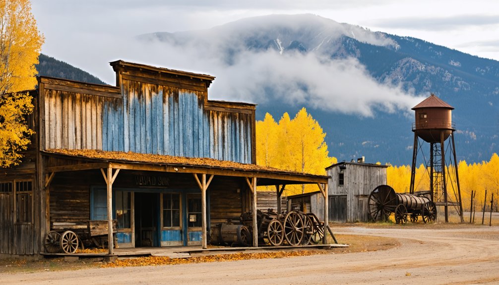
Nestled in the rugged heart of Colorado’s mountains, St. Elmo stands as a monument to America’s wild mining legacy. Founded in 1880, this remarkably preserved ghost town once bustled with 2,000 residents chasing gold and silver dreams.
When you walk its silent streets, you’ll find yourself surrounded by over 150 years of history—original storefronts, the town hall, and schoolhouse all frozen in time.
Unlike many abandoned settlements, St. Elmo survived devastating fires in the 1890s and the collapse of mining in the 1920s.
Today, it’s considered Colorado’s best-preserved ghost town, with a handful of residents still calling it home. You can explore former mining roads by off-road vehicle or hike the nearby Grizzly Lake Trail—perfect for adventurers seeking both freedom and connection to America’s pioneering spirit.
Centralia, Pennsylvania: The Town Still Burning From Below
Beneath the cracked asphalt streets of Centralia, Pennsylvania, a hellish inferno has raged unchecked since 1962, transforming this once-thriving coal mining community into America’s most apocalyptic ghost town.
The earth burns below Centralia, where time stopped in 1962 and nightmares took root.
What began as routine trash burning ignited an underground fire that defied decades of containment efforts.
If you’re brave enough to visit this eerie landscape, you’ll witness:
- Wisps of toxic fumes escaping through fissures in the earth
- Abandoned homes with “Keep Out” signs where 3,000 residents once lived
- Heat-warped roads where temperatures reach dangerous levels
- The last holdout properties of stubborn residents who refused to leave
The underground fire could continue burning for another century as it spreads beneath the empty streets, creating an otherworldly destination for those seeking freedom from ordinary travel experiences.
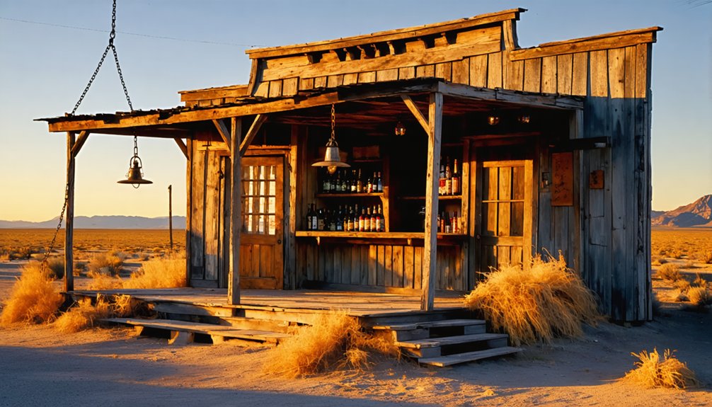
Ruby, Arizona: Murder and Mystery in the Desert
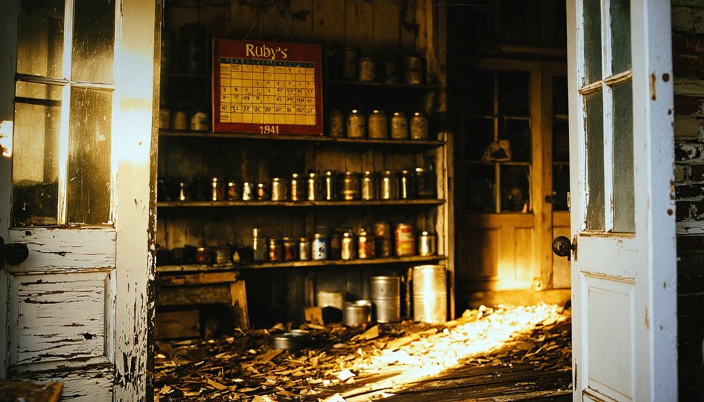
You’ll find Arizona’s bloodiest ghost town clinging to desert hillsides where miners once extracted fortune from the earth while murderers claimed lives at the infamous Ruby Mercantile.
The 1920s double homicides—including the chilling case where a victim’s gold teeth became vital evidence—transformed this mining boomtown into a place of infamy and supposed supernatural curse.
Now privately owned and carefully preserved, Ruby’s crumbling structures stand as silent witnesses to violent deaths that some claim have left restless spirits wandering among the decaying buildings where over 1,200 people once lived and worked.
Bloody Mining History
While most ghost towns have their share of eerie tales, Ruby, Arizona stands apart with a blood-soaked history that’ll make your skin crawl. This once-thriving lead and zinc mining town harbors one of the Southwest’s bloodiest legacies, centered around the infamous Ruby Mercantile.
Between 1920 and 1922, the store became ground zero for shocking mining violence that rocked Arizona:
- The Frazer brothers were murdered by Mexican bandits in February 1920.
- Frank and Myrtle Pearson were brutally killed in August 1921, with Myrtle’s gold teeth knocked out.
- Two lawmen were murdered during the transport of the killers.
- The subsequent manhunt was Arizona’s largest ever, featuring the state’s first aerial search.
You’ll walk the same grounds where these tragedies unfolded, surrounded by abandoned buildings frozen in time since the 1940s.
Unsolved Desert Murders
Ruby’s most chilling chapter revolves around the Ruby Mercantile, where a series of brutal unsolved murders turned this mining town into Arizona’s bloodiest ghost town.
You’ll feel chills as you discover the double homicides that rocked this desert outpost in the 1920s. Mexican bandits murdered both sets of store owners just months apart, gruesomely extracting gold teeth from their victims.
When police finally caught Martinez and Silvas, justice seemed near—until their dramatic escape resulted in two dead officers and Arizona’s first aerial manhunt.
While Martinez eventually hanged, Silvas vanished into thin air after a 1928 prison break, becoming one of Arizona’s enduring desert crime legends.
These unsolved mysteries haunt Ruby today, where whispers of violence and vengeance still echo across the abandoned streets.
Haunted Hillside Ruins
The eerie shadows of Montana Peak stretch across what remains of Ruby, Arizona, a once-thriving mining town where blood-soaked history meets crumbling architecture.
Nestled among the best-preserved ghost towns in Arizona, you’ll find over twenty intact structures where haunted legends persist about an old padre’s grave beneath the mercantile.
As you wander this privately-owned time capsule, remember these ghostly sightings:
- The “pretty nice” spirits reported by the caretaker
- The mysterious “Old Tio Pedro” who predicted doom
- Unexplained phenomena in the old schoolhouse (now a museum)
- Whispers among the doctor’s house timber beams
Though recently closed to public tours, Ruby’s zinc-rich hills once supported 1,200 souls before the ore ran dry in 1940, leaving only silent ruins and supernatural tales.
Frequently Asked Questions
How Safe Is It to Explore These Abandoned Ghost Towns?
Like stepping into Silent Hill, you’re risking your freedom among crumbling floors, criminal activity, and toxic hazards. Take safety precautions—these eerie ruins hide potential dangers beyond their haunting allure.
Are Any of These Towns Completely Off-Limits to Visitors?
Dudleytown and Nihi Island enforce strict off-limits restrictions through active patrols. You’ll face legal consequences if caught trespassing, unlike other ghost towns with visitor regulations allowing exploration.
What’s the Best Time of Year to Visit These Locations?
As shadows stretch across weathered planks, you’ll find ideal visiting windows differ: Bodie (May-October), Calico (December-February), Bannack (July), and St. Elmo (March-May, September-November) offer distinct seasonal weather adventures for your exploration.
Do Any Towns Offer Overnight Accommodation for Ghost-Hunting Experiences?
You’ll find haunted hotels in Terlingua and St. Elmo offering immersive ghost-hunting adventures. Gold Point arranges late-night ghost tours, while Dunton Hot Springs’ historic cabins buzz with paranormal activity and eerie mysteries.
Are There Documented Cases of Paranormal Activity With Evidence?
While skeptics dismiss ghost sightings, Gettysburg’s documented orbs, Hoffman House’s moving objects, and Sarra Gordo’s apparitions offer compelling evidence from paranormal investigations you can witness yourself by exploring these historic haunts.
References
- https://www.visittheusa.com/experience/5-us-ghost-towns-you-must-see
- https://www.mythfolks.com/haunted-us-ghost-towns
- https://www.christywanders.com/2024/08/top-ghost-towns-for-history-buffs.html
- https://www.realgirlreview.com/dark-tourism-in-america/
- https://www.geotab.com/ghost-towns/
- https://en.wikipedia.org/wiki/Lists_of_ghost_towns_in_the_United_States
- https://www.atlasobscura.com/lists/americas-best-preserved-ghost-towns
- https://www.bodiehistory.com
- https://en.wikipedia.org/wiki/Bodie
- https://www.mammothres.com/blog/best-mammoth/spooky-story-bodie-ghost-town


