You’ll discover authentic coal mining ghost towns throughout Southwest Virginia’s 900+ miles of ATV trail networks, including the Spearhead Trails system that transforms former mining corridors into access routes to abandoned company towns, crumbling tipples, and foundation ruins. Navigate the Coal Canyon Trail’s 127 miles through reclaimed mine lands, or tackle Mountain View Trail’s technical terrain to reach ridge-top settlements where commissary stones and boarding house remnants hide among undergrowth. Proper navigation gear and permits grant access to these historical adventures.
Key Takeaways
- Spearhead Trails System connects 400+ miles through abandoned coal camps and historic settlements across seven Southwest Virginia counties.
- Original Pocahontas Trail in Tazewell County offers 65-94 miles through former company towns with guided tours by retired miners.
- Coal Canyon Trail System provides 127 miles accessing ghost settlements, abandoned tipples, and company town remnants on reclaimed lands.
- Mountain View Trail passes crumbling company housing, old tipple ruins, and sawmill foundations across 118 miles of ATV routes.
- Cross-border adventures connect Virginia trails to West Virginia ghost towns like Thurmond, requiring permits from both trail organizations.
Southwest Virginia’s ATV Trail Networks and Historic Mining Communities
When you’re seeking adrenaline-pumping trails that weave through Virginia’s coal country heritage, Southwest Virginia’s ATV networks deliver over 500 miles of purpose-built terrain across five major systems.
You’ll conquer everything from Stone Mountain’s challenging black diamond routes to Grundy’s beginner-friendly green trails spanning historic mining regions.
Jawbone’s 10,000-acre playground welcomes street-legal UTVs and side-by-sides, while Coeburn’s three trailheads offer 274 miles of diverse terrain with motocross access.
Jawbone’s massive 10,000-acre terrain accommodates street-legal vehicles while Coeburn’s expansive trail network provides motocross-ready adventures across 274 diverse miles.
Pocahontas connects you to abandoned coal communities through 94 miles of maintained singletrack.
Each system maintains strict ATV Regulations for safety and environmental protection.
Trail Maintenance crews work year-round ensuring sustainable access to these remote ghost settlements. The Hatfield-McCoy Trail System provides an additional 300 miles of interconnected routes that operate year-round for ATV and UTV enthusiasts. All riders must wear helmets and obtain proper permits before accessing these historic routes.
You’ll experience authentic coal heritage while traversing professionally-designed trails that respect both riding freedom and conservation principles.
Spearhead Trails System: Gateway to Coal Country Ghost Towns
The crown jewel of Southwest Virginia’s trail networks, the Spearhead Trails system transforms 400+ miles of former coal-mining corridors into your direct gateway to authentic ghost-town exploration.
You’ll ride through intentionally routed paths that connect abandoned coal camps, surface mine features, and boom-era settlements from centuries of extraction operations.
Key access points like Pocahontas trailhead deliver you directly to exhibition mine remains and historic coal town overlooks.
Coal Canyon and Jewell Valley connections snake through mining hollows where your ATV can stage visits to accessible abandoned camps.
Jawbone and Stone Mountain segments include mapped routes to foundation ruins visible from designated trails. The veteran convoy experiences add meaningful context to these historic mining routes through organized group rides.
This Spearhead history represents masterful trail preservation—converting extractive lands into recreation assets while maintaining legal access to heritage sites through mixed public-private mining parcels. The system spans seven counties across Southwest Virginia, creating an extensive network for exploring the region’s coal mining heritage.
Coal Canyon Trail System: Exploring Grundy and Haysi’s Mining Heritage
Because Coal Canyon’s 127-mile network carves directly through reclaimed mine lands, you’ll discover the most accessible ATV gateway to Grundy and Haysi’s coal-heritage ghost towns in Southwest Virginia.
You’ll ride converted haul roads and extraction corridors that connect abandoned tipples, ghost settlements, and company town remnants.
Your 50″ ATV or 60″ SxS can tackle the shelf-style cuts and switchbacks descending into Grundy and Haysi.
The CC1 segment offers 11.2 miles of varied terrain plus paved access into town centers for fuel and services.
Trail maintenance keeps these routes open for exploring cultural heritage sites year-round, though you’ll need permits and should check weather closures. The terrain features scenic rock walls and streams with manageable switchbacks throughout the trail system.
Multi-day loops through Ridgeview and Southern Gap connectors let you experience authentic mining landscapes without restrictions or guided tours. The Spearhead Trails network provides additional challenging routes for more experienced riders seeking extended exploration opportunities.
Mountain View Trail: From St. Paul to Abandoned Ridge-Top Settlements
You’ll launch your ridge-top exploration from the Mountain View/St. Paul trailhead on Hidden Acres Road, where 118 miles of interconnected ATV routes await your GPS-equipped adventure into Southwest Virginia’s abandoned coal and timber settlements.
Pack your offline maps and camera gear—these challenging ridge runs will take you past crumbling company housing, old tipple ruins, and sawmill foundations scattered across remote mountain benches. The ATV-friendly town provides direct trail access to accommodations, stores, gas, and food for multi-day ghost town expeditions.
The technical terrain demands solid navigation skills, but you’ll be rewarded with panoramic vista points overlooking the valleys where these forgotten communities once thrived. Many trails offer dispersed camping opportunities along forest service roads, allowing you to extend your ghost town exploration over several days.
St. Paul Trailhead Access
When you’re ready to tackle Virginia’s most challenging ghost town exploration, St. Paul delivers unmatched trailhead amenities for your ridge-bound adventure.
You’ll find the main trailhead at 3461 Hidden Acres Road, positioning you perfectly for direct access into the 118-mile Mountain View system. Unlike remote wilderness starts, St. Paul’s ATV-friendly infrastructure means you can fuel up, grab supplies, and secure lodging within walking distance of the trails.
Your rig launches straight from town center into technical black diamond routes that climb toward abandoned settlements. The trail system extends 100 miles of mountain terrain, connecting you directly to Coeburn through some of Virginia’s most remote backcountry. These trails accommodate riders of various skill levels, making the route accessible whether you’re a weekend warrior or seasoned backcountry explorer.
Download trail maps from SpearheadTrails.com before heading out—cell service won’t follow you into those hollows. While there aren’t on-site rentals, local partners like Western Front Hotel and Extreme Motorsports have you covered for gear and overnight stays.
Historic Mining Settlement Ruins
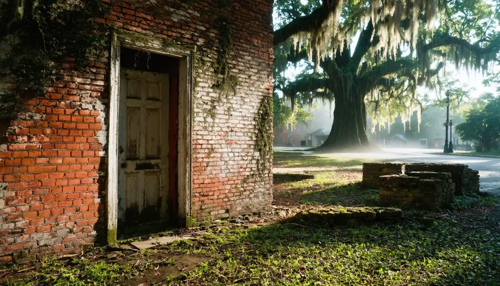
Your ATV will carry you from St. Paul’s trailheads directly into Virginia’s rugged mining heritage, where abandoned settlements cling to ridge-tops like forgotten memories.
You’ll navigate narrow gauge grades and haul roads that once served over 65 small mines across Brush Mountain’s spine. Pack your camera—foundation stones from commissaries and boarding houses emerge from the undergrowth, while collapsed tipples and rusted rail artifacts mark extraction zones.
Your machine handles the steep approaches where spoil piles reshape ridge contours. Cemetery plots and scattered domestic artifacts tell stories of families who called these remote camps home.
The Huckleberry line spurs guide your route through tailings benches and trestle remains. Each ridge reveals new ruins, offering freedom to explore Virginia’s coal camp legacy at your own pace.
Ridge-Top Vista Points
As you climb beyond the mining ruins, the Mountain View Trail transforms into a ridge-running adventure that’ll test your ATV’s suspension across twenty miles of fire roads and rocky spurs leading to Virginia’s most remote overlooks.
Clinch Mountain Overlook delivers 360-degree views from 3,500 feet, while Devil’s Backbone requires a 2.8-mile spur push for unobstructed Stone Mountain Wilderness vistas.
High Knob claims Virginia’s crown at 4,223 feet, where fire tower ruins frame your panoramic photography sessions. Hurricane Fork‘s sheer drop-offs span fifty miles on clear days.
You’ll encounter ridge top wildlife including black bears and wild turkeys. Pack telephoto lenses and polarizing filters—these elevated positions demand quality optics to capture the expansive Clinch River Valley spreading beneath your boots.
Original Pocahontas Trail: Tazewell County’s Mining History by ATV
Deep in Tazewell County’s forested ridges, the Original Pocahontas Trail delivers you directly into Virginia’s most storied coal mining territory, where abandoned portals and crumbling tipple foundations tell the tale of America’s industrial backbone.
These ATV trails stretch 65-94 miles through former company towns, giving you unfiltered access to Pocahontas mining sites that powered America’s naval fleet.
You’ll need day permits ($30) and helmets before exploring intermediate blue routes that wind past spoil piles and forgotten rail grades.
Start from Pocahontas trailhead on Railroad Alley, then navigate to the Exhibition Mine using downloadable KMZ files.
Local retired-miner guides share firsthand accounts while you stand where coal barons built their empire, freedom rolling beneath your tires.
Cross-Border Adventures: West Virginia Ghost Towns Near Virginia Trails

You’ll find some of West Virginia’s most accessible ghost towns by connecting your Virginia ATV routes to cross-border trail systems that lead directly to abandoned mining settlements.
The historic railroad town of Thurmond serves as your gateway hub, where you can link up with the extensive Hatfield-McCoy trail network that spans both states.
Pack your navigation gear and extra fuel—these interconnected trails open up five major ghost towns within riding distance of Virginia’s eastern borders.
Thurmond Railroad Town Access
Once you reach the overlook, you’re positioned perfectly to explore this legendary Railroad History site that generated more C&O freight revenue than major cities combined.
The restored 1904 depot now serves as your base camp for New River adventures. Pack light hiking gear for steep terrain exploration, fishing equipment for riverside access, and cameras for capturing remnants of America’s coal-shipping empire.
The narrow floodplain below tells stories of switching yards that once assembled coal trains destined for eastern markets.
Hatfield-McCoy Trail Connections
Beyond Virginia’s coal heritage sites, the Hatfield-McCoy Trail system opens up cross-border ghost town exploration that’ll test your ATV skills across rugged Appalachian terrain.
You’ll need valid permits from both Hatfield-McCoy and Spearhead organizations for seamless riding between West Virginia and Virginia’s interconnected systems.
The Pocahontas Trail connects directly to Virginia’s Spearhead Trails through the new border connector, linking you to over 800 miles of continuous riding.
Access Bramwell’s historic millionaire mansions via Trail 34, then push deeper into ghost mining communities scattered throughout Indian Ridge, Pinnacle Creek, and Warrior systems.
Stage from Coaldale’s trailhead with full amenities, or fuel up in ATV-friendly towns like Matewan and Williamson.
These Hatfield McCoy connections deliver authentic backcountry adventures through abandoned settlements where coal once ruled Appalachia.
Thurmond and New River Gorge: Railroad Boom Town Ruins
Deep within New River Gorge‘s rugged terrain lies Thurmond, a railroad ghost town that’ll transport you back to West Virginia’s coal-mining heyday. This former boomtown once generated more coal freight revenue than Cincinnati, handling $5 million annually while serving 100,000 passengers.
You’ll discover preserved 1930s buildings including the National Bank and depot, accessible through challenging backcountry routes.
Thurmond history reveals a town where Main Street was literally railroad tracks, supporting fifteen daily passenger trains. The steam engine repair yards and coal assembly facilities made this the C&O Railroad’s largest revenue producer.
Today’s New River exploration offers hiking trails, fishing access, and mountain biking opportunities. Pack your adventure gear – this remote ghost town demands proper preparation for terrain navigation and overnight camping.
Hatfield-McCoy Corridor: Coal Camp Remnants and Ghost Sites

While the legendary Hatfield-McCoy feud captured headlines, the coal camps scattered throughout this rugged corridor tell an equally compelling story of boom, bust, and abandonment.
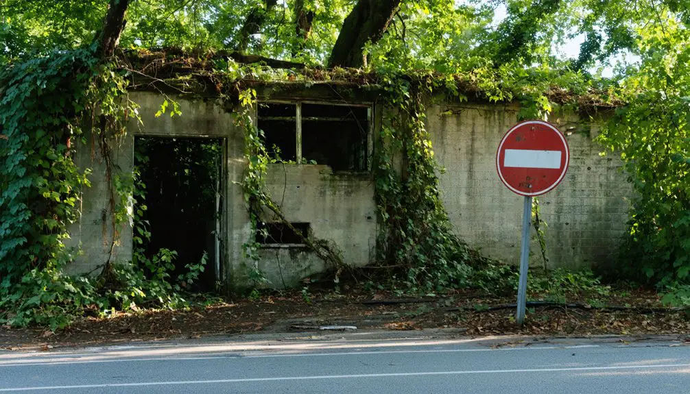
You’ll find remnants of Stonega, Keokee, and Inman camps accessible through ATV corridors that wind through West Virginia’s coal heritage region. These linear settlements showcase distinctive coal camp architecture—commissaries, theaters, churches, and company housing built by operations like Virginia Coal and Iron Company.
Your ATV exploration reveals the harsh realities of mining community lifestyle, where families paid with company scrip and lived under corporate control.
Navigate these ghost sites to discover abandoned structures from diverse communities, including Eastern European immigrants who built Catholic churches alongside Baptist congregations in these forgotten hollows.
Permits, Regulations, and Street Riding in Historic Towns
Before you fire up your ATV to explore Virginia’s historic ghost towns, you’ll need to navigate a complex web of permits, age restrictions, and street-riding regulations that vary dramatically by county and municipality.
Permit requirements are strict—you’ll need annual permits for trails like Jewell Valley, while street riding‘s generally prohibited except on VDOT-approved roads in specific counties.
Annual trail permits are mandatory for locations like Jewell Valley, with street riding banned except on specific VDOT-approved county roads.
Riding regulations demand helmets for all operators, 16+ age minimums, and daylight-only operation on designated roads with 25 mph speed limits.
Buchanan County offers more freedom with designated road access between trails, but you’re limited to one-mile stretches.
Cities can seize unlawfully operated ATVs, so respect private property boundaries and secure written consent before crossing onto someone else’s land while pursuing those elusive ghost town adventures.
Safety and Preservation Guidelines for Ghost Town Exploration

You’ll face serious structural hazards when exploring Virginia’s abandoned settlements, from unstable foundations and hidden debris to collapsing mine shafts that can trap your ATV or cause injury.
Your exploration activities must comply with strict environmental protection requirements that govern disturbance of historic sites, artifact removal, and trail impact to preserve these cultural resources.
Before you fire up your machine, you need to navigate complex legal access restrictions involving private property rights, trespassing laws, and federal protections that can result in hefty fines or prosecution.
Structural Hazards and Risks
When you’re threading your ATV through Virginia’s backcountry to reach forgotten settlements, you’ll encounter structures that’ve been battling time and weather for decades—and losing.
These skeletal remains pose serious threats to your safety protocols. Unreinforced masonry walls can collapse without warning from nearby vibrations or your footsteps. Rotted roof rafters and compromised floors won’t support your weight, creating deadly drop zones.
Hidden soft spots lurk beneath debris-covered surfaces. Corroded metal connectors have lost their grip, turning once-solid buildings into house-of-cards scenarios.
Foundation erosion creates unstable walls that can shift suddenly. Before approaching any structure, assess its structural integrity from a safe distance. Trust your instincts—if something looks sketchy, it probably is.
Environmental Protection Requirements
Beyond protecting yourself from crumbling structures, your ghost town adventures must respect the fragile ecosystems that’ve reclaimed these abandoned sites.
Your ATV’s environmental impact on Virginia’s backcountry demands serious consideration—waterways, soil, and vegetation face real threats from improper riding.
You’ll need spark arrestors installed and functioning before hitting Spearhead Trails, where researchers documented fifteen potential environmental violations across 100 miles.
Stick to designated paths to prevent erosion and sediment runoff that damages streams. Wildlife preservation requires limiting habitat fragmentation—these abandoned settlements often harbor sensitive species recovering in human absence.
Carry liability insurance, maintain 25-mph speeds on connecting highways, and follow posted signage religiously.
Your freedom to explore depends on responsible riding that preserves these historical landscapes for future adventurers.
Legal Access Restrictions
Although Virginia’s ghost towns beckon with promises of hidden history, traversing the legal maze of ATV access requires understanding complex restrictions that vary dramatically by county and trail system.
You’ll face speed limits capped at 25 mph on public connector roads, with distances restricted to one mile between destinations. Legal restrictions demand helmet compliance for all riders, while age requirements limit operators under 16 on most trail systems.
Trail signage becomes your navigation bible—VDOT-approved markers guide you through approved routes during daylight hours only. Private property surrounding ghost town sites requires explicit owner consent, and violations trigger swift penalties including fines and vehicle impoundment.
Master these regulations before your wheels hit dirt.
Frequently Asked Questions
Can I Camp Overnight at Ghost Town Sites Along ATV Trails?
You’ll need permits and landowner permission since camping regulations typically prohibit overnight stays at ghost towns. These sites lack ghost town amenities, so pack everything you’ll need and secure proper authorization first.
What’s the Best Season to Visit Virginia’s Atv-Accessible Ghost Towns?
Fall’s your prime season with best weather hitting 40-65°F and minimal rain. You’ll get stellar visibility through bare trees, epic fall colors, and firm trail conditions for tackling ghost town runs without mud bogging your rig.
Are Guided Ghost Town ATV Tours Available in Southwest Virginia?
You’ll find guided tours through Southwest Virginia’s “forgotten settlements” with local guides who know every trail twist. These adventure-focused outfitters near Haysi and Grundy’ll gear you up for freedom-seeking exploration through historic mining country.
Do I Need Special Insurance for ATV Ghost Town Exploration?
You don’t need special ATV insurance legally, but smart riders grab liability and extensive coverage options. Basic protection costs under $100 annually—cheap insurance against costly accidents while exploring Virginia’s abandoned territories.
Which Ghost Towns Have the Most Intact Structures Still Standing?
Thurmond’s your best bet for historic preservation – most buildings remain intact with history displays. Coalwood offers solid urban exploration opportunities with that ivy-covered machine shop. Both locations provide excellent structure access for adventurous riders.
References
- https://www.virginia.org/things-to-do/sports-and-recreation/atv-and-spearhead-trails/
- https://www.breakspark.com/atv
- https://www.islands.com/2019470/williamson-nestled-heart-appalachia-west-virginia-mountain-town-great-outdoor-adventure-massive-hatfield-mccoy-trail/
- https://www.youtube.com/watch?v=oIKh2MuA-gY
- https://wvtourism.com/west-virginia-paranormal-trail/
- https://www.youtube.com/watch?v=fLY985imGXQ
- https://wvtourism.com/5-wv-ghost-towns/
- https://thurmondwv.org/pages/visiting-thurmond
- https://www.tripadvisor.com/Attraction_Review-g59586-d2708213-Reviews-Thurmond_Depot-Thurmond_West_Virginia.html
- https://spearheadtrails.com/pages/atv-trails