You’ll find Washington’s ghost towns require careful navigation due to complex access restrictions and land ownership boundaries. Monte Cristo Mining Camp offers ATV access via Barlow Pass Corridor, while Franklin Coal Town near Black Diamond requires hiking the final two miles. Sherman’s abandoned church allows dirt road access with landowner permission, and remote mining settlements like Ruby Townsite connect through established Discovery Route corridors. Proper permits, recovery equipment, and current USFS maps prove essential for these technical expeditions.
Key Takeaways
- Monte Cristo Mining Camp requires navigating Barlow Pass Corridor restrictions with steep grades and technical stream crossings at 1,600-2,000 feet elevation.
- Franklin Coal Town prohibits motorized vehicles on official trail, requiring 2-mile hike from Black Diamond with unstable mine shaft hazards present.
- Sherman ghost town allows straightforward ATV access via dirt roads northeast of Govan, but requires explicit landowner permission for access.
- Melmont ghost town requires 6-mile roundtrip hike along old railroad grade near Mount Rainier due to National Park boundary restrictions.
- Ruby Townsite and Nighthawk offer ATV access through established Discovery Route corridors connecting to regional BDR networks in Okanogan Country.
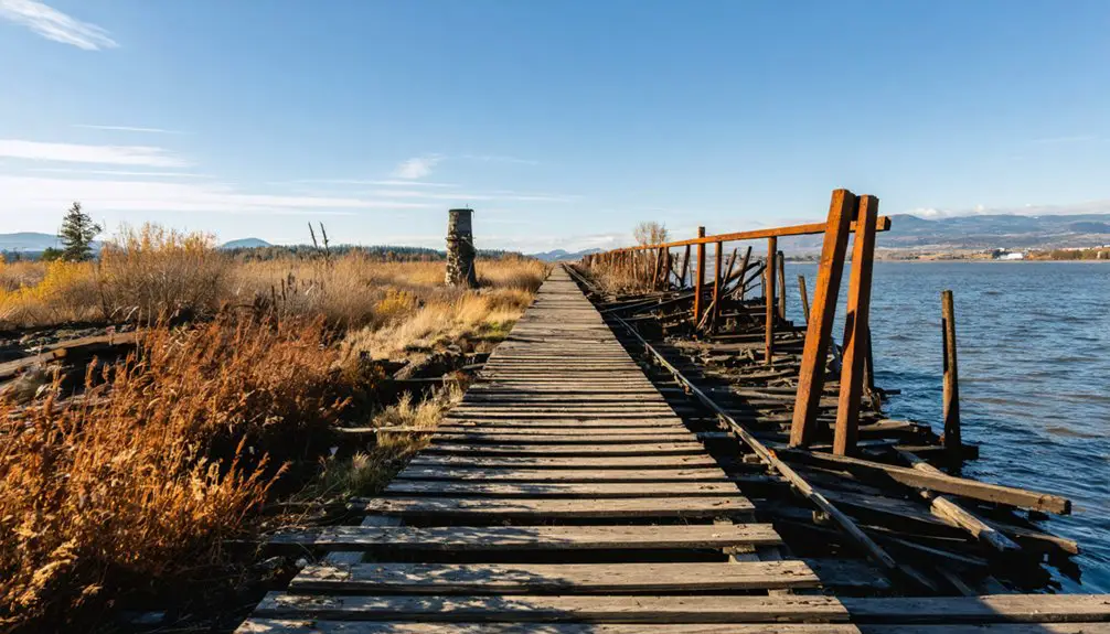
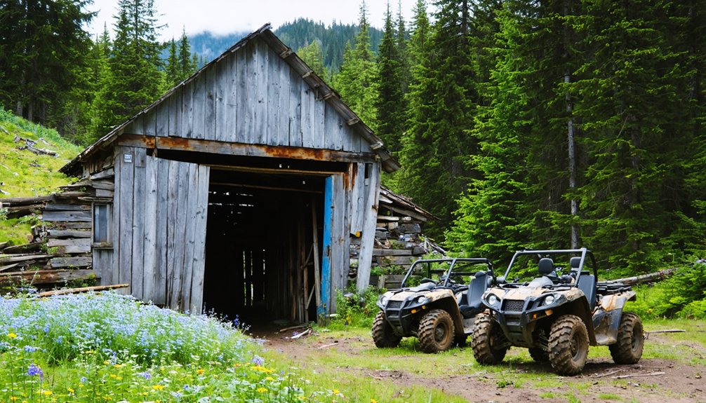
Monte Cristo Mining Camp via Barlow Pass Corridor
When planning an ATV expedition to Monte Cristo’s abandoned mining camp, you’ll need to navigate complex access restrictions through the Barlow Pass Corridor, where the old Monte Cristo Road (Forest Road 41) crosses Mount Baker-Snoqualmie National Forest lands with strict motorized-use limitations.
Complex forest service regulations and motorized-use restrictions make careful pre-trip planning essential for Monte Cristo ATV access.
You must obtain current USFS Motor Vehicle Use Maps and verify ATV regulations before departure, as most historical routes now restrict mechanized travel to designated trails only.
The Monte Cristo history includes devastating flood damage that left bridges collapsed and road sections impassable.
You’ll encounter steep grades, washouts, and technical stream crossings at 1,600-2,000 feet elevation. The trail follows sections of the old Monte Cristo Railroad grade, which has historical significance related to the mining activities in the area.
This former mining district once yielded an estimated $300 to $350 per ton of silver ore during its peak operations.
Summer and fall provide ideal conditions when snow doesn’t block access.
Pack recovery equipment, extra fuel, and emergency supplies—cellular coverage remains spotty throughout this demanding backcountry corridor.
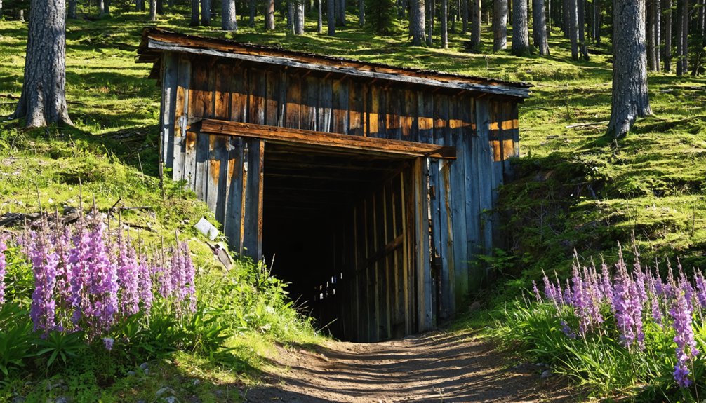
Franklin Coal Town Near Black Diamond
You’ll find Franklin Coal Town’s remnants require careful route planning since the official Franklin Coal Mine Trail prohibits motorized vehicles and demands a 2-mile hike from Black Diamond.
Before attempting ATV access, verify current land permissions with King County Parks, as the rugged Green River Gorge terrain contains unstable mine shafts and sealed concrete structures that pose significant safety hazards.
Your equipment should include proper safety gear, GPS navigation, and emergency communication devices due to the remote location’s proximity to 1,300-foot-deep sealed mine shafts. The area became a ghost town after coal mining operations ceased in 1971, with the final Franklin No. 10 mine closing on March 27, 1971. Franklin’s original residents were former workers from Nortonville, California coal mines who relocated when the Black Diamond Coal Mining Company established operations in the 1880s.
Coal Mining History
Deep within the Green River Gorge east of Black Diamond, Franklin Coal Town represents one of Washington’s most significant mining operations, where the Oregon Improvement Company established extensive underground workings in 1884 that would eventually reach 500 feet below sea level.
You’ll discover sophisticated mining techniques that included the construction of a massive 1,300-foot No. 2 shaft measuring 10’6″ x 18’8″. The narrow-gauge railroad proved essential for hauling equipment and extracting coal, with the first 96-ton shipment departing July 21, 1885.
Town evolution accelerated rapidly as mining infrastructure expanded, supporting 1,000 residents by the early 1900s. The diverse immigrant population from Europe created a multicultural community that left behind gravestones reflecting their varied origins. Coal cars and rock-filled shafts remain visible today, demonstrating the scale of operations that dominated the Green River district until declining demand forced closure in 1919. The community operated with such harmony that there was no need for law enforcement throughout its active years.
Trail Access Routes
Three distinct access methods will get you to Franklin Coal Town’s remains, though only one provides direct trailhead access for the historic site itself.
You’ll reach the primary trailhead via Green River Gorge Road’s paved section, then navigate an unpaved dirt turnoff to the small parking area. This route offers minimal trailhead amenities—just an honor-box fee system and basic dirt lot conditions.
Parking limitations become critical during peak seasons and wet weather when the informal mud lot reaches capacity.
Alternative staging involves nearby Forest Service roads like NF 7720000 near Wilkeson, where you can establish base camps with your ATV equipment before hiking in. This wide trail starts at approximately three car widths before narrowing to single-lane sections. The actual hike to Franklin follows an old railroad grade with minimal elevation gain once you begin the walking portion.
The Elbe Hills ORV area provides established motorized corridors for regional access, though you’ll still need to complete the final approach on foot to preserve the historic site’s integrity.
Safety and Permissions
Before you load your ATV and head toward Franklin’s remnants, understand that this historic site operates under complex land ownership and access restrictions that differ considerably from standard ORV areas.
You’ll need explicit landowner permission since no statewide ORV designation exists for Franklin’s interpretive trail—it’s designated for hiking only. Your Discover Pass won’t authorize motorized access here, unlike nearby DNR forest roads.
Safety precautions become critical given sealed mine shafts, subsidence zones, and concealed openings throughout the area. Always check for burn bans before visiting, as fire restrictions frequently affect access to historical sites during dry conditions. The overgrown trails have steep drop-offs that pose additional hazards to visitors navigating the unmaintained paths.
Permission requirements change rapidly because private parcels control parking and trail access, often charging honor-box fees. Always verify current ownership, posted restrictions, and seasonal closures before riding.
Contact local landowners directly rather than assuming your standard forest permits apply to this mixed public-private ghost town site.
Sherman and Melmont Rail-Grade Adventures
You’ll find Sherman’s abandoned church and cemetery accessible via dirt roads northeast of Govan, while Melmont’s rail-grade trail requires a 6-mile roundtrip hike along the old railroad alignment near Mount Rainier.
Your ATV access faces significant restrictions since Melmont traverses National Park boundaries where motorized vehicles aren’t permitted, and Sherman’s approaches cross private farmland requiring landowner permission.
Plan your rides around seasonal closures—Mowich Lake Road shuts down in winter, and Sherman’s dirt access roads become impassable during wet conditions.
Historic Rail Grade Access
While Sherman’s open terrain allows straightforward ATV access across Washington’s eastern plains, Melmont’s ghost town remnants require traversing the abandoned Northern Pacific rail grade that once carried coal cars from the Carbon River mines.
You’ll navigate Pierce County Parks-owned infrastructure designed for the future Foothills Trail, starting near the National Register-listed Fairfax Bridge.
The rail grade presents technical challenges: mossy retaining walls, muddy conditions from heavy ATV usage, and a dynamite storage shed marking your route.
Melmont history reveals this 1900-founded coal mining operation peaked at 4% of Pierce County’s production before railroad technology shifts ended demand.
Expect 6-mile roundtrips through challenging terrain requiring proper mud-rated tires and protective gear for safe exploration.
Seasonal Riding Conditions
When planning ATV expeditions to Sherman and Melmont’s ghost town sites, you’ll encounter dramatically different seasonal challenges that directly impact trail accessibility and safety requirements.
Spring thaw creates treacherous conditions from mid-March through late May, forcing trail closures beginning April 1 until stable ground returns. Water filters slowly through unstable soils, creating washouts that reduce passages to single lanes requiring barricade navigation.
Summer stabilization transforms these routes by mid-to-late May, delivering ideal riding conditions through firm, dry surfaces. You’ll find trail access remains reliable through November 30, when winter restrictions begin.
Monitor crowd-sourced reports from Sherman region riders for real-time conditions. Essential gear includes proper permits—Northwest Forest Pass for federal lands, Discover Pass for state areas—ensuring unrestricted access to these historic rail-grade adventures.
Remote Mining Settlements Along Backcountry Discovery Routes
Remote mining settlements scattered across Washington’s backcountry offer ATV enthusiasts access to authentic ghost towns through established Discovery Route corridors and connecting two-track spurs.
Among these remote locations, adventurers can explore ghost towns submerged in Washington, remnants of a bygone era. With scenic landscapes and rich histories waiting to be uncovered, each destination presents a unique glimpse into the past. As explorers traverse the rugged terrain, they may stumble upon stories etched in time, making each journey an exciting discovery.
Ruby Townsite and Nighthawk provide prime examples where BDR-style routes intersect historic mining camps, creating natural navigation networks for high-clearance vehicles.
Navigate these backcountry discovery routes with precision planning:
- Route Integration: Ruby City connects via Forest Service roads to regional BDR corridors in Okanogan Country
- Access Points: Nighthawk links through Loomis/Oroville loop roads with established two-track approaches
- Navigation Tools: Current topo maps essential for landslide-prone drainages and washed-out segments
- Legal Compliance: Verify motorized access on mixed Forest Service/private ownership patchwork
You’ll find these mining settlements preserve stone foundations, mill ruins, and original structures while offering legitimate motorized access through established backcountry networks.
Teanaway Valley Logging Communities and Casland
Cascading timber operations transformed Washington’s Teanaway Valley into a bustling industrial corridor where the ghost town of Casland anchors your exploration of authentic logging history accessible via maintained forest roads.
You’ll navigate 50,272 acres of Teanaway Community Forest using established ATV routes through former railroad grades and logging spurs.
Casland history reveals a complete company town operating from 1917-1930s with infrastructure including machine shops, bunkhouses, and narrow-gauge railroad connections to Cascade Lumber Company operations.
Your ATV handles rough terrain where buildings stood until 1972, now transformed into grassland camping areas.
Teanaway restoration efforts decommissioned two-thirds of logging roads, eliminating 190 tons of annual sediment runoff.
Crystal-clear rivers replace the brown flood waters that once carried timber downstream, providing pristine backcountry access near Cle Elum.
Blue Lake ORV System and Historic Mining Sites
Technical terrain and panoramic vistas define the Blue Lake ORV System‘s 21-mile loop network, where your ATV navigates Trails #270, #271, and #271A through historic mining territory within Gifford Pinchot National Forest.
Ridge-line segments deliver sweeping views of Mt. Adams, Mt. Rainier, and Mt. St. Helens while you explore remnants of past prospecting operations scattered throughout the volcanic highlands.
Your machine must comply with essential operational parameters:
- 50-inch maximum width restriction enforced on all trail segments
- Forest Service day-use fee ($5 daily or $30 annual pass) required
- April-October operating season with 24-hour access when conditions permit
- Technical creek crossings and steep grades demand mechanical readiness
Mining artifacts emerge along spurs and side roads, where historic prospecting evidence connects you to the region’s extractive heritage while challenging your riding skills through demanding backcountry terrain.
Planning Your Washington Ghost Town ATV Expedition
Before you throttle into Washington’s backcountry ghost towns, your expedition demands meticulous preparation across permit requirements, seasonal timing, and gear selection.
ATV regulations require OHV permits for designated Okanogan trails, while spark arrestors and noise restrictions guarantee compliance. Your Washington State Discover Pass grants DNR land access to sites like Monte Cristo.
Summer delivers prime conditions for ghost town exploration, avoiding winter snow closures on Mountain Loop Highway and spring mud on Melmont’s abandoned rail grade.
Pack GPS tracks for Northwest Passage routes to Chesaw, repair kits for remote Baldy Mountain runs, and first aid supplies for mine site injuries.
Plan Loomis-Similkameen-Oroville loops accessing Nighthawk, or tackle Okanogan Country roads reaching Bodie.
Signal boosters combat poor Okanogan Highlands coverage during your freedom-seeking adventure.
Frequently Asked Questions
What Permits or Fees Are Required for ATV Access to Ghost Towns?
You’ll need ORV tabs or registration, plus Discover Pass or Northwest Forest Pass for trailhead parking. ATV regulations vary by land manager, while access restrictions include designated route requirements and potential seasonal closures.
Are There Restrooms or Water Available at These Remote Historic Sites?
Restroom availability’s extremely limited at remote sites—you’ll rarely find facilities. Water sources exist but aren’t treated, requiring purification equipment. Pack your own water supplies and plan waste disposal strategies beforehand.
Can Children Safely Ride ATVS to These Ghost Town Locations?
Children can safely ride ATVs to ghost towns if you follow strict age restrictions, use properly-sized vehicles, guarantee complete safety gear compliance, and maintain constant adult supervision throughout remote terrain.
What Should I Do if My ATV Breaks Down at a Remote Site?
Like stranded explorers facing uncharted wilderness, you’ll need your breakdown kit’s multi-tool and duct tape for repairs. Signal emergency contacts immediately, move off-trail safely, and assess your machine systematically before attempting field fixes.
Are Camping Reservations Needed for Overnight Trips to Ghost Town Areas?
You don’t need reservations for free dispersed camping near ghost town areas unless posted signs indicate otherwise. Follow proper camping etiquette while exploring ghost town history, and carry backup equipment for remote overnight adventures.
References
- https://stateofwatourism.com/ghost-towns-of-washington-state/
- https://www.youtube.com/watch?v=d2ToBOyaiQs
- https://www.youtube.com/watch?v=6FOAbt70OY8
- https://ridebdr.com/wabdr/
- https://www.youtube.com/watch?v=PJfKMi771YE
- https://newashingtontrails.com/old-stage/
- https://kimatv.com/news/local/explore-the-ghost-town-of-casland-in-roots-of-the-valley
- https://www.youtube.com/watch?v=FVveO9uJBvc
- https://westernmininghistory.com/towns/washington/monte-cristo/
- https://www.ghosttownsofwashington.com/post/ghosts-of-monte-cristo-gold