Explore America’s forgotten riverine communities, where history flows beneath reservoir waters and erodes with changing shorelines. You’ll discover towns deliberately submerged during dam construction, Indigenous sites sacrificed for water management, and once-thriving ports abandoned as transportation networks evolved. From Celilo Falls to Rodney, Mississippi, these ghost towns reveal America’s complex relationship with its waterways through half-submerged church steeples, overgrown cemeteries, and haunting local legends that keep submerged stories afloat.
Key Takeaways
- Many river ghost towns were deliberately submerged by dam projects, like Brownlee and Detroit, Oregon in the 1950s.
- Indigenous communities suffered cultural erasure when ancestral lands were flooded, notably Celilo Falls beneath The Dalles Dam.
- Catastrophic floods destroyed river towns like Vanport, Oregon and completely washed away Napoleon, Arkansas.
- Economic abandonment occurred when transportation shifted from rivers to railroads, isolating communities and causing population decline.
- Physical remnants like Rodney’s structures and cemeteries serve as historical markers, while supernatural folklore preserves cultural memory.
Submerged by Progress: Towns Lost to Dam Projects

When the United States commenced on its ambitious dam-building era in the twentieth century, dozens of communities were sacrificed to what officials deemed national progress.
Towns like Brownlee, Oregon and Detroit, Oregon vanished beneath rising reservoir waters in the 1950s, their residents forcibly relocated with little recourse.
The cultural erasure proved particularly devastating for Indigenous peoples.
The flooding of ancestral lands silenced tribal voices and severed Indigenous connections to place and history.
Celilo Falls, a centuries-old tribal fishing ground, disappeared under The Dalles Dam in 1957, severing ancestral connections despite monetary compensation.
You’ll find similar stories across the American West—from Elbowoods, North Dakota to St. Thomas, Nevada—where community displacement occurred systematically between the 1920s and 1970s.
Lake Mead’s rising waters in 1938 completely submerged the Mormon settlement of St. Thomas, with its forty building foundations now visible only during severe drought periods.
Most towns were methodically razed before flooding, with buildings burned to the ground and orchards deliberately uprooted to prevent navigation hazards.
While dams brought electricity, irrigation, and flood control to millions, they simultaneously erased irreplaceable cultural landscapes and community bonds, leaving only underwater ruins as evidence of these sacrifices.
River Disasters: Communities Washed Away by Nature’s Force
Unlike the deliberate flooding from dam projects, many American communities have been obliterated by the unbridled force of natural river disasters. The catastrophic 1882 flood that destroyed Ben Ficklin, Texas, claimed over 60 lives, while Vanport, Oregon’s destruction in 1948 displaced nearly 18,000 residents—both stark examples of historical flood impacts.
You’ll find few remnants of towns like Napoleon, Arkansas, completely washed away by the Mississippi, or the Oregon settlements of Champoeg, Linn City, and Orleans—all victims of the devastating 1862 flood. The absence of river resilience strategies proved fatal for these communities. Similar to Shauny Town, Illinois, which experienced catastrophic flooding in 1937 and was ultimately abandoned after repeated inundations despite rebuilding efforts.
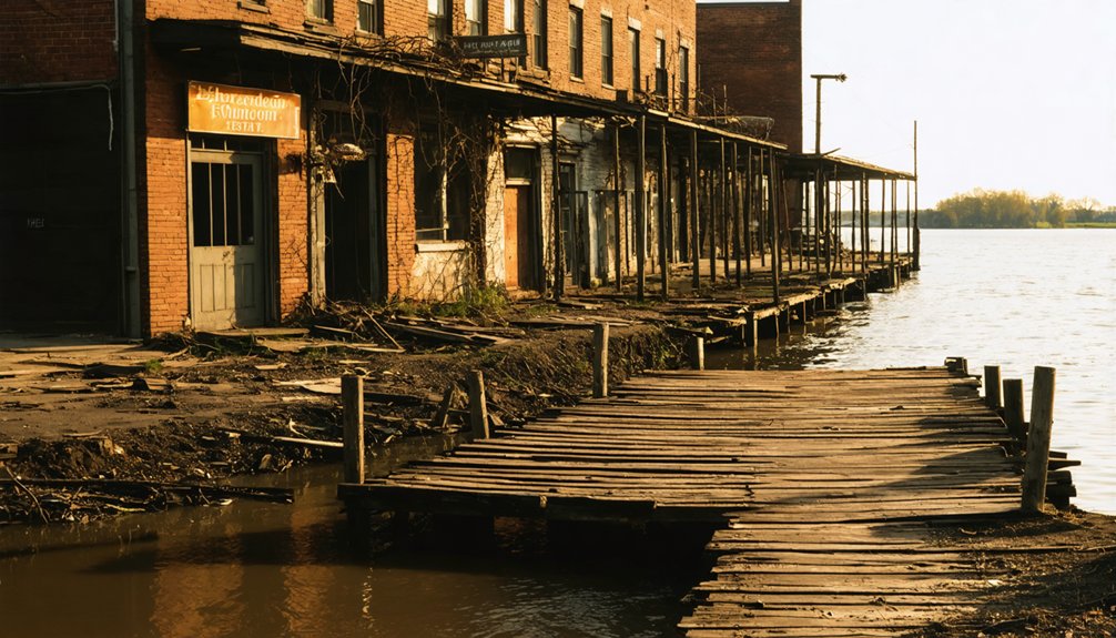
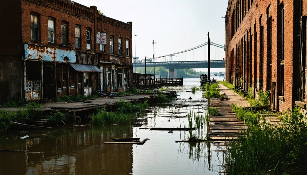
Even established towns like Rodney, Mississippi, and Old Cahawba, Alabama, gradually surrendered to persistent flooding and changing river courses, their abandoned structures standing as silent monuments to nature’s dominance. Unlike these natural disasters, towns like Proctor, North Carolina were deliberately submerged beneath Fontana Lake to provide electricity during World War II.
Indigenous Heritage Underwater: Cultural Sites Beneath Reservoirs
Beneath the placid surfaces of America’s reservoirs lie the submerged remains of indigenous cultural heritage, sacrificed to twentieth-century water management priorities.
You’ll find ironic juxtapositions where ancient indigenous water management systems—some functioning effectively for millennia—were deliberately flooded to create modern reservoirs.
Like the Maya’s sophisticated gravity-fed systems that provided potable water for over 1,000 years, numerous indigenous engineering achievements now rest underwater. The ancient Maya developed urban reservoir systems that successfully managed water scarcity during dry seasons across hundreds of cities in Mesoamerica.
Rising sea levels threaten nearly 33,000 archaeological sites along coastal margins, with projections indicating over 19,600 sites will submerge with just one meter of sea-level rise. A collaborative Digital Index database called DINAA has documented this alarming vulnerability of archaeological resources across southeastern states.
Cultural preservation efforts include underwater museums and documentation initiatives through databases like Canmore, though these face significant challenges.
The UNESCO-supported approaches preserve submerged relics while maintaining public accessibility—a small consolation for the irreplaceable indigenous knowledge systems lost beneath the waters.
The Economics of Abandonment: When River Towns Lost Their Purpose
You’ll find that America’s ghost towns often emerged when industries abandoned river communities, leaving economic devastation in their wake.
As resource extraction operations like mining, logging, and fishing depleted or became uneconomical, towns lost their primary purpose and faced immediate collapse.
The shift of transportation networks away from rivers to railroads and highways further isolated these communities, accelerating their descent into abandonment as businesses, jobs, and eventually residents departed. This downward spiral can be seen in places like Youngstown, Ohio, where high vacancy rates demonstrate the long-term effects of economic decline on once-vibrant communities. The rise of national supermarkets and mail-order businesses during the early twentieth century further undermined local economies in these vulnerable river towns.
When Industry Departed
The economic abandonment of America’s once-thriving river towns marks a profound shift in the nation’s industrial geography, wherein the gradual withdrawal of manufacturing, shipping, and agricultural enterprises precipitated demographic collapse and municipal deterioration.
You’ll find these economic decline patterns throughout the Mississippi Delta, where the cotton industry’s collapse during the Great Depression initiated the exodus. When railroads and highways redirected commerce away from waterways, river towns lost their commercial purpose.
Many communities have experienced population decreases exceeding 30% since 1990, as industrial closures eliminated job opportunities. Similarly, settlements along the Colorado River have faced abandonment as water depletion threatens agricultural viability and economic sustainability.
The community displacement wasn’t merely economic—it represented the dissolution of cultural identity. As businesses shuttered, tax revenues plummeted, diminishing public services.
This cycle of disinvestment transformed once-bustling commercial centers into hollow shells, their abandoned storefronts testifying to America’s shifting industrial landscape. Corona, Tennessee exemplifies this decline, with its population dropping from 281 in 1950 to just 15 residents by 2022.
Shifting Transportation Networks
As transportation networks evolved throughout the nineteenth century, America’s river towns faced existential challenges that would permanently alter their economic foundations and civic identities.
This transportation evolution redirected commerce from waterways to rail corridors, leaving once-thriving ports economically marginalized.
You’ll find three defining characteristics of this economic transformation:
- Railroads delivered goods faster and more reliably than steamboats, operating year-round without the seasonal interruptions that plagued river commerce.
- Towns that failed to secure rail connections watched helplessly as trade diverted to inland rail centers, causing warehouses and supporting businesses to close.
- Urban development patterns shifted dramatically, with growth following rail lines rather than riverbanks, abandoning waterfronts that had once been centers of commercial activity.
This shift rendered many river towns obsolete, transforming vibrant communities into forgotten footnotes of American economic history.
Exploring What Remains: Visible Ruins and Remembrance
Wandering through America’s forgotten riverside communities today, you’ll encounter a spectrum of physical remnants that tell stories of prosperity, decline, and abandonment.
From Rodney’s flood-damaged structures to Kennecott’s well-preserved mining infrastructure, these visible remnants vary dramatically in their historical significance and condition. You’ll find Matildaville’s ruins transformed into hiking trails, while No Business offers little more than scattered stone piles.
Cemeteries often serve as the most poignant testimonials to these vanished communities.
Rodney’s three-acre burial ground, with its 200+ graves dating to 1828, provides tangible connections to past inhabitants. These memorial sites, though frequently victim to natural forces like flooding and erosion, remain vital focal points for descendants and history enthusiasts seeking to preserve the memory of America’s river ghost towns.
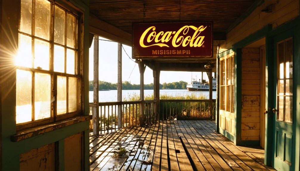
Ghost Stories and Legends: The Folklore of Drowned Towns
You’ll encounter persistent narratives of spectral figures and eerie phenomena across America’s submerged river towns, where catastrophic floods and intentional reservoir creation have trapped communities beneath the waves.
These underwater ghost towns, from Rodney, Mississippi to Proctor, North Carolina, generate folklore connecting tragic histories to supernatural manifestations, including phantom church bells and ghostly reenactments of historical tragedies.
Similar stories can be found in the ghost towns of the Pacific Northwest, where abandoned mining communities whisper tales of their once-thriving existence. Visitors report eerie sights and sounds that seem to echo the past, igniting curiosity about the lives once lived there. These forgotten places serve as a reminder of the region’s turbulent history and the unexplainable phenomena that often accompany it.
The cyclical nature of river destruction—particularly evident in towns repeatedly claimed by floodwaters—reinforces cultural beliefs that displaced spirits remain tethered to their vanished communities, creating a rich tapestry of haunted water legends that blend historical fact with supernatural interpretation.
Watery Apparitions Emerge
The haunting folklore of drowned towns reveals a rich tapestry of supernatural phenomena that transcends mere historical documentation of catastrophic events.
These watery tales persist across continents, with European traditions offering striking parallels to American submerged legends.
When you visit sites of these aquatic ghost towns, you’ll often encounter stories of spectral manifestations that follow consistent patterns:
- Phantom church bells ringing from beneath the waters, as reported in both Friesland’s Saint Odulf Abbey and the French city of Ys
- Mysterious lights glimmering from submerged palaces and structures on specific nights
- Disembodied voices crying out from the depths, sometimes prophesying future retribution
These supernatural elements serve critical functions beyond entertainment, explaining geological phenomena and preserving cultural memory through generations.
Communities Below Waves
Beneath America’s reservoir-created lakes lie more than physical remnants of drowned communities—they harbor rich tapestries of folklore that blend historical trauma with supernatural elements.
These narratives preserve the emotional legacy of displaced towns like Etowah and Loyston, where government-mandated evacuations severed generational ties to ancestral lands.
You’ll find these stories especially potent in Appalachia, where oral traditions recount how spirits of the unrelocated dead still linger near submerged cemeteries.
During droughts, when forgotten headstones and building foundations reemerge, these tales intensify.
Cherokee legends intertwine with settler accounts, creating a complex mythology around places like the flooded Coosawattee Valley.
This folklore serves a critical purpose—maintaining community identity despite geographic dissolution, transforming material loss into cultural memory that resists complete erasure.
Mapping America’s Lost River Communities: Regional Highlights
Throughout America’s vast river systems, patterns of loss and submersion reveal the precarious relationship between human settlements and waterways.
These river histories display distinct regional characteristics, with community legacies preserved through documentation despite physical erasure.
Three key regional patterns emerge:
- Eastern US – Communities like Proctor, NC and Andersonville, SC sacrificed to reservoir creation, with unfulfilled promises of infrastructure replacement and relocated cemeteries.
- Mississippi River Basin – Towns including Napoleon, AR and Kaskaskia, IL lost to natural channel migration rather than planned inundation, demonstrating the river’s autonomous power.
- Western US – Native fisheries and settlements along the Columbia and Snake Rivers submerged by mid-20th century dam projects, erasing both communities and indigenous cultural sites.
Frequently Asked Questions
Can You Legally Salvage Artifacts From Submerged Ghost Towns?
No, you can’t legally salvage artifacts without proper permits. Federal and state legal regulations protect submerged sites, requiring authorization for removal while prioritizing artifact preservation over personal collection rights.
How Do Seasonal Water Level Changes Affect Visibility of Submerged Ruins?
When the chips are down in dry seasons, you’ll witness greater water visibility of submerged ruins. Seasonal fluctuations create predictable windows for exploration, with spring floods concealing structures and summer-fall droughts revealing them.
Are There Any Ongoing Efforts to Restore or Relocate Drowned Towns?
You’ll find numerous restoration projects underway, from Klamath River Basin’s dam removal to cultural initiatives preserving historical memory through art installations. Federal funding supports ecological rehabilitation while some communities face managed relocations rather than complete historical preservation.
What Documentation Existed Before These Towns Were Flooded?
Nearly 4,000 communities were submerged in the 20th century alone. You’ll find extensive historical records including USGS maps, census data, newspapers, and archaeological surveys documented these towns before the waters claimed them.
How Have Former Residents Maintained Community Connections After Displacement?
You’ll find former residents sustain connections through family-like networks, community gatherings, preservation societies, and online forums. They share narratives of displacement, organize reunions, and often relocate within geographical proximity to maintain cultural continuity.
References
- https://www.neh.gov/article/atlas-drowned-towns
- https://www.drownedtowns.com/about
- https://en.wikipedia.org/wiki/List_of_flooded_towns_in_the_United_States
- https://www.mentalfloss.com/geography/wanderlust/creepiest-ghost-towns-united-states
- https://www.wideopencountry.com/the-10-eeriest-ghost-towns-in-america/
- https://www.geotab.com/ghost-towns/
- https://www.loveexploring.com/gallerylist/188219/the-us-state-with-the-most-ghost-towns-revealed
- https://jasontdunn.com/files/ghost_towns_big_cities.pdf
- https://www.lovemoney.com/gallerylist/86648/americas-empty-ghost-towns-and-why-theyre-abandoned-today
- https://www.boisestate.edu/news/2020/05/18/with-a-new-grant-professor-aims-to-catalog-drowned-towns-of-the-american-west/