You’ll find five remarkable ghost towns within a short drive of Silverton, each preserving Colorado’s mining heritage above 9,800 feet. Animas Forks sits highest at 11,200 feet with nine original buildings, while Eureka showcases the innovative Sunnyside Mill ruins. Howardsville served as an essential supply hub, Ironton functioned as a railroad gateway, and Red Mountain Town perched at 11,300 feet amid Colorado’s second-richest silver district. The 63-mile Alpine Loop connects these sites via challenging 4WD roads, best navigated June through early October to discover the complete story behind each settlement’s rise and abandonment.
Key Takeaways
- Animas Forks, Colorado’s highest ghost town at 11,200 feet, features nine preserved buildings including the Duncan House and Old Jail.
- Eureka sits at 9,860 feet with Sunnyside Mill ruins, once Colorado’s largest gold producer employing over 300 workers.
- Howardsville served as a strategic supply hub four miles east of Silverton, operating corrals and ore-loading platforms until 1939.
- Ironton, seven miles south of Ouray, grew to 300 buildings as a freight transfer point along the Million Dollar Highway.
- Red Mountain Town at 11,300 feet extracted $30 million in silver before the 1893 crash and 1895 fire ended operations.
Animas Forks: Colorado’s Highest Ghost Town
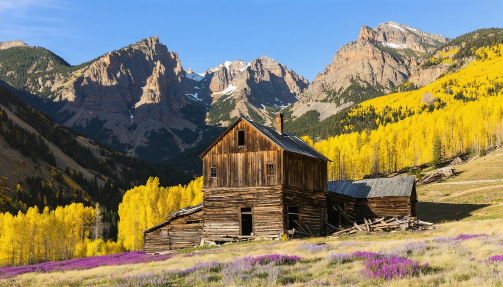
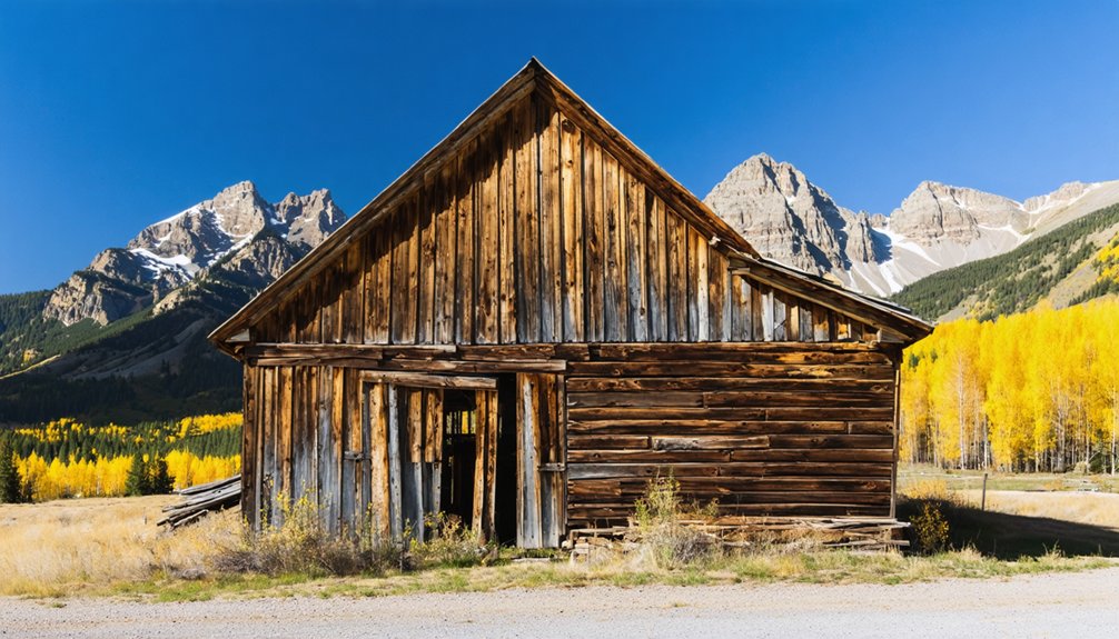
Perched at approximately 11,200 feet in a narrow alpine valley 12 miles northeast of Silverton, Animas Forks stands as Colorado’s highest ghost town and one of the most elevated mining camps in North America.
At 11,200 feet above sea level, Animas Forks claims the distinction of Colorado’s highest ghost town.
You’ll discover surviving wood-frame cabins, the distinctive Duncan House with its bay window, and foundations of the Gold Prince Mill—remnants of a settlement that housed 1,500 residents during the 1880s silver boom.
The town’s Historical Significance earned it National Register status, preserving evidence of Mining Techniques that extracted precious ore until 1910.
Nine original buildings remain standing today, including the Gustavson House and The Old Jail, carefully preserved by the BLM to serve as a time capsule of Colorado’s mining heritage.
Access requires a high-clearance 4WD vehicle along the Alpine Loop’s unpaved routes, best traveled summer through early fall when conditions allow exploration of these fragile structures managed by the Bureau of Land Management.
Informational signs throughout the site provide historical context about the town’s buildings and their original inhabitants.
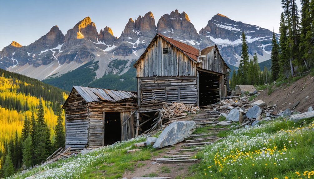
Eureka and the Sunnyside Ore Mill Ruins
Just downstream from Animas Forks, you’ll find Eureka nestled along the river valley at roughly 9,860 feet, where the relocated Sunnyside Mill once processed ore from the district’s most productive mine.
The town secured its post office in 1875 and grew steadily as a mill center rather than a boom camp, serving hundreds of workers until rail service ended in the late 1930s. The Sunnyside Mine itself became Colorado’s largest gold producer by 1937 before closing in 1939 due to exhausted ore reserves.
Today you can explore scattered structural remains, mill foundations, and the riverside flats where this industrial community anchored the upper Animas mining corridor for more than six decades. The Silverton Northern railroad brought vital connections to the area when it reached Eureka in 1896, transforming the town’s accessibility and economic prospects.
Eureka’s Mining Town History
Tucked along the Animas River between Silverton and Animas Forks, Eureka holds the distinction of marking the San Juan region’s first documented gold discovery when Charles Baker’s party found placer gold there in 1860.
The Ute Tribe drove prospectors out in 1861, defending their treaty-protected territory. Mining resumed around 1871–1873 following Ute land cessions, with lode gold discovered in the Little Giant vein.
A permanent mining community formed in the early 1870s, centered on the Sunnyside Mine‘s development. The post office operated from August 1875 to April 1942, serving a population that peaked near 2,000 residents between 1899 and the 1930s.
Unlike typical boomtowns, Eureka’s legacy reflects sustained growth from Sunnyside’s five-decade production run. The Silverton Northern Railroad connected Eureka to neighboring mining communities, supporting operations at the Sunnyside and Gold Prince mines. The Sunnyside Mill’s selective flotation process made it the first plant in North America to apply this technique on complex ores, contributing to the town’s prosperity through the early twentieth century.
Sunnyside Mill Structure Remains
Eureka’s fortunes rose and fell with the Sunnyside Mine, and nowhere is this relationship more visible than in the massive mill complex that once dominated the valley.
The Sunnyside Mill employed over 300 workers during its peak, processing complex zinc-lead-iron sulfide ores through pioneering selective flotation methods. As the first Colorado mine to reach 1,000 tons per day throughput, its multi-level gravity-flow concentrator stepped down the hillside above the Animas River.
Today’s structural remnants tell a story of technological ambition. You’ll find scattered foundations, rusted machinery fragments, and collapsed framework where the terraced processing buildings once stood. An aerial tramway connected the original surface plant at Lake Emma, located over 12,000 feet elevation, to this mill site 3 miles away, transporting ore from the late 1896 onward.
The 1939 closure triggered Eureka’s rapid decline, and by 1942, even the railroad tracks were gone. ASARCO purchased the Sunnyside Mine and nearby mines in 1917, consolidating operations before building this mill capable of processing 500 tons per day. These ruins mark Colorado’s metallurgical innovation frontier.
Visiting Eureka Ghost Site
The graded dirt ribbon of County Road 2 carries you northeast from Silverton along the Animas River to Eureka’s scattered remnants at 9,860 feet, where a single restored jail stands as the lone intact building among foundations and rubble.
Eureka access requires high-clearance vehicles and checking local conditions—spring runoff and late-season snow regularly restrict passage through this narrow valley corridor.
Eureka elevation brings thin air and abbreviated seasons; count on late spring through fall windows only.
You’ll trace visible railroad grades from the 1896 Silverton Northern line while stone platforms and concrete pads mark vanished boarding houses and businesses. The Denver and Rio Grande Railroad connection arrived in 1876, linking this remote mining district to markets and supplies.
The archaeological character rewards exploration on foot: meadows conceal cribbing, mountainsides shelter foundation walls, and every pile of hand-cut timber frames questions about who lived, worked, and departed when the Sunnyside mill closed in 1939. Gold prospectors first arrived in 1860, though permanent settlement waited until after the 1873 Brunot Treaty resolved conflicts with the Ute Nation.
Howardsville: An Early San Juan Mining Camp
You’ll find Howardsville four miles east of Silverton, where it once served as the primary supply point for mines throughout the upper Animas River valley from the 1870s through the early 1900s.
The town’s fortunes shifted dramatically when the Denver & Rio Grande Railroad reached Silverton in 1882, diverting commercial traffic and eroding Howardsville’s strategic importance as a distribution hub.
Today, scattered remnants of the Pride of the West Mill, Little Nation Mill, and the Old Hundred Mine complex mark the settlement that briefly held La Plata County’s seat of government before fading into obscurity.
Supply Point for Mines
Established in 1874 along the Animas River, Howardsville emerged as one of the San Juan’s first organized mining camps and quickly assumed the role of primary supply point for high-country operations spreading through Cunningham Gulch and the upper Animas district.
Located four miles east of Silverton at a strategic valley junction, you’ll find where wagon and pack-train routes converged to reach Eureka, Animas Forks, and dozens of remote claims above timberline.
Howardsville logistics centered on freighting, warehousing, and transshipment—receiving bulk goods from Silverton’s railhead after 1882, then distributing machinery, timber, fuel, and provisions to mines operating at elevations where winter closed roads for months.
The town’s mining supply infrastructure included corrals, storage sheds, and ore-loading platforms that kept high-country operations running year-round.
Decline and Present Ruins
After Howardsville served as La Plata County seat in 1874, its civic prominence lasted barely a year before the creation of San Juan County transferred governmental authority to Silverton, stripping away the administrative functions that had anchored the settlement’s regional importance.
The 1882 arrival of the Denver & Rio Grande line to Silverton accelerated Howardsville’s decline, diverting commerce and traffic.
Though the Silverton Northern Railroad reached Howardsville in the 1890s, it came too late. The post office closure in 1939 marked the end of permanent habitation.
Today you’ll find Howardsville history preserved in scattered foundations, mine dumps, and the Little Nation Mill—one of only two similar ore-reduction facilities surviving in the San Juans—a reflection of the area’s enduring mining legacy.
Ironton: Gateway Along the Million Dollar Highway
Seven miles south of Ouray, Ironton sprawls across the flat valley floor of Ironton Park—a rare stretch of level ground in the otherwise vertical terrain of the San Juan Mountains.
Founded in 1893 and initially called Copper Glen, the town exploded to 300 buildings within months.
Ironton history centers on its role as a staging point rather than a mining camp. The Silverton Railroad reached here in November 1888, establishing a vital freight transfer point.
Ironton transportation infrastructure made it indispensable: Otto Mears’ toll road—now Highway 550’s Million Dollar Highway segment—funneled ore wagons and supplies between Ouray and Red Mountain District camps.
You’ll find moose and elk grazing where 1,500–2,000 miners once paused before tackling Red Mountain Pass‘s brutal grades.
Red Mountain Town: The Jewel of Red Mountain Pass
Perched at 11,300 feet on Red Mountain Pass, Red Mountain Town commanded Colorado’s second-richest silver district after Leadville, extracting an estimated $30 million from the iron-stained peaks that gave the settlement its name.
You’ll find what’s left of this once-thriving camp along Colorado Highway 550, where the Yankee Girl, Guston, and National Belle mines employed nearly 1,000 residents during the late 1880s.
The Silverton Railroad’s arrival in 1888 transformed silver mining operations, slashing shipping costs and enabling profitable ore transport to Durango and Pueblo smelters.
Yet the 1893 silver crash gutted the district’s largest operations. An 1895 fire delivered the final blow, and by 1899, only scattered holdouts remained among the ruins.
Exploring the Alpine Loop Ghost Town Trail
Winding 63 miles through the San Juan Mountains, the Alpine Loop Scenic Byway connects three historic mining towns—Silverton, Lake City, and Ouray—while threading past some of Colorado’s most dramatic ghost town remnants.
You’ll need a high-clearance 4WD to tackle this backcountry route, accessible June through early October when snow clears from its 12,800-foot passes.
Among scenic drives in Colorado’s mining districts, this loop stands unmatched for historic preservation. BLM-maintained Animas Forks (established 1873) showcases an 1882 jail with 6-inch walls, while Capitol City’s photogenic post office marks founder George Lee’s failed bid for state capital status.
Sherman and Gladstone add to the collection of mining-era structures you’ll encounter.
Budget 4-6 hours for the complete circuit, though weekend dust from heavy traffic can slow progress considerably.
Frequently Asked Questions
Are Any Ghost Towns Near Silverton Safe to Visit With Children?
Animas Forks preserves nine original structures from the 1870s, offering family safety through unrestricted building access and BLM interpretive materials. You’ll find kid-friendly activities exploring authentic mining-era architecture at 11,200 feet elevation, though you’ll need high-clearance vehicles for summer access.
Can I Camp Overnight at Ghost Town Sites Around Silverton?
You’ll need to verify site-specific camping regulations before pitching your tent at ghost towns. Most sites prohibit overnight stays, but dispersed camping’s permitted one mile away following proper ghost town etiquette and backcountry protocols.
Understanding the history of Beartown, Colorado can enhance your experience as you explore its remnants. As you wander through the abandoned structures, consider the stories of those who once inhabited the area. This knowledge not only adds depth to your visit but also fosters a greater appreciation for the rugged beauty of the surrounding landscape.
Another fascinating example is the history of Talcott ghost town, where remnants of its railroad significance can still be seen. Exploring the overgrown tracks and dilapidated buildings offers a glimpse into the life that once thrived in this now-silent place. As you delve deeper into the town’s past, you may find intriguing artifacts that tell the story of its rise and eventual decline.
What’s the Best Time of Year to Visit Silverton Ghost Towns?
Summer releases the high country—late June through September offers ideal access to Silverton’s ghost towns. You’ll navigate seasonal attractions like wildflower-draped ruins while weather considerations favor morning exploration before afternoon thunderstorms roll in.
Do I Need Permits to Explore Ghost Towns Near Silverton?
You don’t need permits for casual exploration, but you’ll face restrictions if you enter private claims, disturb structures of historical significance, or ignore established exploration guidelines that protect artifacts and prohibit excavation.
Are There Guided Tours Available for Silverton-Area Ghost Towns?
Yes, you’ll find multiple guided tour options for Silverton-area ghost towns. Expert-led excursions include 2.5-hour Jeep tours to Animas Forks, ATV adventures, and combined mine-and-ghost-town experiences, typically priced around $129–$149 per adult.
exploring silverton’s historical significance can deepen your appreciation for the area’s rich mining heritage. Visitors are often astonished by the well-preserved structures and stories that vividly recount the town’s past. Each tour offers a unique glimpse into the lives of those who shaped Silverton’s development during its peak.
References
- https://www.durango.com/colorado-ghost-towns/
- https://www.uniquetravelphoto.com/animas-forks-ghost-town-in-silverton-colorado/
- https://www.uncovercolorado.com/ghost-towns/animas-forks/
- https://www.colorado.com/articles/colorado-ghost-towns
- https://www.youtube.com/watch?v=N0mNOeRG-lk
- https://www.visitouray.com/ghost-towns
- https://savingplaces.org/stories/ghost-of-a-chance-animas-forks-colorado
- http://www.watsonswander.com/2014/silverton-mountains-mines-ghost-towns/
- https://airial.travel/attractions/united-states/animas-forks/animas-forks-ghost-town–nHtWGSb
- https://www.youtube.com/watch?v=r1_pnNhNWxY


