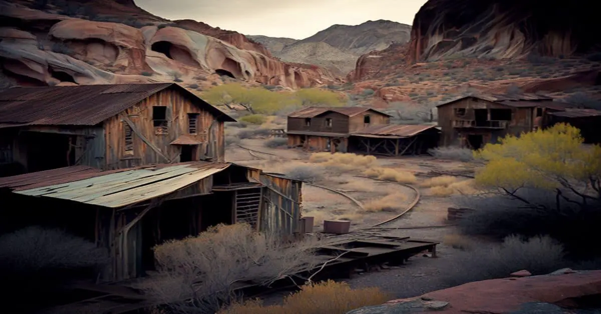
Antrim City, MI
County:
Zip Code:
Latitude / Longitude:
Elevation:
Time Zone: Eastern (EST) (UTC-5)
Established:
Disestablished:
Comments: Antrim City was a short-lived settlement on the Lake Michigan shores. Wood, Pearl and Company began shipping operations circa 1861. A post office operated from July 21, 1862, until April 19, 1882. The principals behind Wood, Pearl and Company, Orvis Wood, Lucius Pearl and Orin Adams had moved operations to Norwood, Michigan by 1867.
Remains:
Current Status:
Remarks:
Aral, MI
County:
Zip Code:
Latitude / Longitude:
Elevation:
Time Zone: Eastern (EST) (UTC-5)
Established:
Disestablished:
Comments: Aral was built at the mouth of Otter Creek on Lake Michigan in 1880. It was built around the Otter Creek Lumber Mill. It was named after Aral, Ireland, because “Otter Creek” was already the name of another place in Michigan. It had a post office from 1884 until 1900.
Remains:
Current Status:
Remarks:
Atkinson, MI
County:
Zip Code:
Latitude / Longitude: 42° 22′ 45.84″ N, 83° 5′ 38.04″ W
Elevation:
Time Zone: Eastern (EST) (UTC-5)
Established:
Disestablished:
Comments: Atkinson Avenue is an east/west street located in the geographic heart of the city of Detroit, Michigan. The historic district had 225 houses in 2010.
Remains: Atkinson Avenue was named in honor of William Francis Atkinson. Held prisoner by the Confederacy, Atkinson courageously escaped and rose to the rank of captain before leaving the service in 1886. Captain Atkinson had a commendable war record. Long after the Civil War, he studied law and was admitted to the bar.
Current Status: Atkinson Avenue consists of parts of six subdivisions, specifically Joy Farm, Lewis Park, Jackson Park, Voigt Park, Boston Boulevard, and Guerold’s Subdivision. The adjacent Boston-Edison Historic District is composed of the same subdivisions. The Atkinson Avenue Historic District, however, only includes those six blocks of Atkinson Avenue situated between the John C. Lodge Expressway and Linwood Avenue. The Atkinson Avenue Historic District, as it exists today, was established by action of the Detroit City Council in March 1984 (Journal City Council 262 66, passed March 7, 1984 and effective March 26, 1984). All remaining portions of Atkinson Avenue are not within the boundaries of any historic district.
Remarks: In its entirety, Atkinson Avenue begins at Woodward Avenue and travels westerly to Linwood Avenue, where Atkinson Avenue abruptly stops. Atkinson Avenue resumes at Savery Avenue and continues traveling westerly to its final terminus at McQuade Avenue, just west of Dexter Boulevard. For a time, during the 1890s, that portion of Atkinson Avenue situated between 12th Street and “Crawford” Street (later renamed “Hamilton”), actually constituted a part of the boundary of Detroit’s city limits.
Baltic, MI
County:
Zip Code:
Latitude / Longitude: 47°04’03″N 88°38’00″W
Elevation:
Time Zone: Eastern (EST) (UTC-5)
Established:
Disestablished:
Comments: Baltic is an unincorporated community southeast of South Range at 47°04’03″N 88°38’00″W. It was a station on the Copper Range Railroad and the settlement was founded by and named after the Baltic Mining Company in 1898. A post office operated here from November 6, 1902, until October 10, 1975.
Remains:
Current Status:
Remarks:
Berringer Corners, MI
County:
Zip Code:
Latitude / Longitude:
Elevation:
Time Zone: Eastern (EST) (UTC-5)
Established:
Disestablished:
Comments:
Remains:
Current Status:
Remarks:
Berryville, MI
County:
Zip Code:
Latitude / Longitude:
Elevation:
Time Zone: Eastern (EST) (UTC-5)
Established:
Disestablished:
Comments:
Remains:
Current Status:
Remarks:
Bertrand, MI
County:
Zip Code:
Latitude / Longitude: 41° 46′ 27″ N, 86° 15′ 45″ W
Elevation:
Time Zone: Eastern (EST) (UTC-5)
Established:
Disestablished:
Comments: Bertrand is an unincorporated community in the southern part of the Niles Charter Township at 41°46’27″N 86°15’45″W on the St. Joseph River approximately 4 miles (6 km) south of Niles.
Remains: Joseph Bertrand, a French Canadian, had a trading post here by 1812. He had married the daughter of a Potawatomi chief and through her had acquired land. After the Potowatomi ceded their lands to the federal government with the 1833 Treaty of Chicago, Daniel G. Garnsey obtained the permission of U.S. President Andrew Jackson and the consent of Mrs. Bertrand to locate a village on her land. Alonzo Bennett platted the village of Bertrand in 1833 and became its first postmaster on June 9, 1834.
Current Status: The town was a stop on the Detroit-Chicago road. In 1844, the Sisters of the Holy Cross founded their first convent in the United States here. The town gradually declined after it was by-passed by railroads. The post office closed on April 15, 1901.
Remarks: Bertrand Township lies to the west and south, Buchanan Township to the west, and Berrien Township to the north. Neighboring townships in Cass are Pokagon Township to the northeast, Howard Township to the east, and Milton Township to the southeast. To the south in St. Joseph, Indiana, is Clay Township, and German Township is to the southwest.
Big Rock, MI
County:
Zip Code:
Latitude / Longitude:
Elevation:
Time Zone: Eastern (EST) (UTC-5)
Established:
Disestablished:
Comments:
Remains:
Current Status:
Remarks:
Bingham, MI
County: Huron
Zip Code:
Latitude / Longitude: 43°43’3″N 82°56’12″W
Elevation: 797 ft (243 m)
Time Zone: Eastern (EST) (UTC-5)
Established: 1863
Disestablished:
Comments: Bingham Township is a civil township of Huron in the U.S. state of Michigan. As of the 2000 census, the township population was 1,751. The township is named for Kinsley S. Bingham, a U.S. Representative and U.S. Senator from and Governor of Michigan. Bingham Township was established in 1863.
Remains:
Current Status:
Remarks:
Bolton, MI
County: Alpena
Zip Code:
Latitude / Longitude: 45°10’53″N 83°35’23″W
Elevation:
Time Zone: Eastern (EST) (UTC-5)
Established:
Disestablished:
Comments: Bolton is an unincorporated community in theMaple Ridge Township approximately 12 miles (19 km) northwest of Alpena along the partially abandoned Detroit and Mackinac Railway at 45°10’53″N 83°35’23″W. It was named for Henry Bolton, who along with Donal McRae opened a general store in Alpena in 1866. From 1871, as Bolton & McRae, they operated one of the leading cedar lumbering firms in the area. A post office operated here from October 1880 until March 1955.
Remains:
Current Status:
Remarks:
Bond’s Mill, MI
County:
Zip Code:
Latitude / Longitude:
Elevation:
Time Zone: Eastern (EST) (UTC-5)
Established:
Disestablished:
Comments:
Remains:
Current Status:
Remarks:
Branch, MI
County: Mason
Zip Code:
Latitude / Longitude: 43°56’45″N 86°02’21″W
Elevation:
Time Zone: Eastern (EST) (UTC-5)
Established:
Disestablished:
Comments: Branch is an unincorporated community on US 10 on the boundary between Mason and Lake at 43°56’45″N 86°02’21″W. The community shares its name with Branch Township in Mason, but is also within Sweetwater Township in Lake. It was founded about 1873 by Benjamin F. Barnett, who built a lumbermen’s hotel. The Pere Marquette Railway later ran the hotel and made it a station. Barnett became the first postmaster of Branch, in Mason, on February 1, 1876, named for the township, which in turn is named for the north branch of the Pere Marquette River. On October 1, 1962, the post office was transferred to Lake. The Branch ZIP code 49402 serves most of Sweetwater township, as well as in Lake, the western parts of Sauble Township and Lake Township and a small area of Webber Township. In Mason, the ZIP code serves the eastern parts of Branch Township and Sheridan Township, most of Logan Township, and small areas of Meade Township, Eden Township, and Custer Township and a small area of Colfax Township in Oceana.
Remains:
Current Status:
Remarks:
Brookside, MI
County:
Zip Code:
Latitude / Longitude:
Elevation:
Time Zone: Eastern (EST) (UTC-5)
Established:
Disestablished:
Comments: Brookside, a small suburb of Traverse City on Franke Road behind Meijer. Located in the Garfield Township, Michigan.
Remains:
Current Status:
Remarks:
Butternut, MI
County:
Zip Code:
Latitude / Longitude:
Elevation:
Time Zone: Eastern (EST) (UTC-5)
Established:
Disestablished:
Comments:
Remains:
Current Status:
Remarks:
Calvin Center, MI
County: Cass
Zip Code:
Latitude / Longitude: 41°51’31″N 85°56’54″W
Elevation: 830 ft (253 m)
Time Zone: Eastern (EST) (UTC-5)
Established:
Disestablished:
Comments: Calvin Township is a civil township of Cass in the U.S. state of Michigan. The population was 2,037 at the 2010 census.
Remains: Calvin Township’s first public school was built in 1834. Calvin Township was organized in 1835 and named for Calvin Britain who represented Cass in the state legislature. Calvin Township along with Cass generally was part of the Underground Railroad. In 1850 Calvin Township’s population was 25.3% African-American.
Current Status:
Remarks:
Cambridge Junction, MI
County: Lenawee
Zip Code:
Latitude / Longitude: 42°2’39″N 84°10’58″W
Elevation: 971 ft (296 m)
Time Zone: Eastern (EST) (UTC-5)
Established:
Disestablished:
Comments: Cambridge Township is a civil township of Lenawee in the U.S. state of Michigan. The population was 5,299 at the 2000 census.
Remains: The village of Onsted is in the southern part of the township. Springville is an unincorporated community on M-50 in the central portion of the township at 42°02’00″N 84°10’16″W. A post office operated from January 21, 1835, until August 31, 1905.
Current Status:
Remarks:
Central, MI
County:
Zip Code:
Latitude / Longitude:
Elevation:
Time Zone: Eastern (EST) (UTC-5)
Established:
Disestablished:
Comments: Central was a settlement around the Central Mine founded in 1854. It was largely settled by Cornish people. It got a post office in 1871. The mine closed in 1898 and the post office was closed in 1906.
Remains:
Current Status: It then became a ghost town although the Methodist Church was maintained and descendants of the former residents would make annual trips back to it at least until the 1970s.
Remarks:
Chestonia, MI
County: Antrim
Zip Code:
Latitude / Longitude: 44°58’32″N 85°2’14″W
Elevation: 1,004 ft (306 m)
Time Zone: Eastern (EST) (UTC-5)
Established:
Disestablished:
Comments: Chestonia Township is a civil township of Antrim in the U.S. state of Michigan. The population was 511 at the 2010 census. From 1901 to 1932, the junction of the East Jordan and Southern and the Detroit & Charlevoix railroads lay within the township. Chestonia Township was organized in 1874.
Remains:
Current Status:
Remarks:
Cleon, MI
County: Manistee
Zip Code:
Latitude / Longitude: 44°28’16″N 85°53’17″W
Elevation: 883 ft (269 m)
Time Zone: Eastern (EST) (UTC-5)
Established:
Disestablished:
Comments: Cleon Township is a civil township of Manistee located in the U.S. state of Michigan. The population was 932 at the 2000 census.
Remains: Cleon was an unincorporated community on the Manistee River that was settled in 1865. It had a post office from 1871 until 1902.
Current Status:
Remarks:
Clifton, MI
County: Keweenaw
Zip Code:
Latitude / Longitude: 47° 22′ 32″ N, 88° 18′ 12″ W
Elevation:
Time Zone: Eastern (EST) (UTC-5)
Established:
Disestablished:
Comments: Clifton was a community in Allouez Township, Keweenaw, Michigan, that was founded in support of the Cliff mine—a mine opened in 1845 by the Pittsburgh and Boston Mining Company after copper was discovered there. It is located between Calumet and Eagle Harbor, off of Cliff Drive, alongside US 41 in the Keweenaw Peninsula. A historical marker is present at the site.
Remains: Mining was the main source of employment, drawing men of different nationalities, including Irish, German, French Canadians, and Cornish men. Clifton had only a few churches, including Catholic and Episcopal. Their masses were spoken in many different languages, including English, French and German. Along with religious groups, there were also organizational groups including: The Independent Order of Good Templars, the Band of Hope, and the Independent Order of Odd Fellows.
Current Status: At one point, the town supported an independent brewery, called the Clifton Bottling Works. After the Cliff mine exhausted the copper deposit, the town became deserted. Two cemeteries remain. One is at the base of the cliff by the mine. This is the original cemetery. The second was established when the railroad came through and the town was moved to be closer to the tracks, about a half mile east of the mine.
Remarks:
Colonville, MI
County:
Zip Code:
Latitude / Longitude: 43° 50′ 39″ N, 84° 42′ 21″ W
Elevation:
Time Zone: Eastern (EST) (UTC-5)
Established:
Disestablished:
Comments: Colonville is a mostly historical settlement in the township at 43°50’39″N 84°42’21″W. Storekeeper Curtis Palmer was the first postmaster of a rural post office here, which operated from December 4, 1894, until January 15, 1904.
Remains:
Current Status:
Remarks:
Copper Falls Mine, MI
County:
Zip Code:
Latitude / Longitude: 47° 25′ 30″ N, 88° 12′ 0″ W
Elevation:
Time Zone: Eastern (EST) (UTC-5)
Established:
Disestablished:
Comments: Copper Falls mine was a set of numerous copper mine shafts and adits south of Eagle Harbor, Michigan. The mine was established in 1846. The mine is in Eagle Harbor Township, near the Copper Falls water fall on the Owl Creek and the Copper Falls ghost town.
Remains:
Current Status:
Remarks:
Crawfords Quarry, MI
County:
Zip Code:
Latitude / Longitude:
Elevation:
Time Zone: Eastern (EST) (UTC-5)
Established:
Disestablished:
Comments: Crawfords Quarry was a former settlement in Michigan, United States. It was established in 1864, and abandoned in 1900. In 1910 the location was resettled with the new name of Calcite. It is now within the city boundaries of Rogers City, Michigan.
Remains:
Current Status:
Remarks:
Crescent, MI
County:
Zip Code:
Latitude / Longitude:
Elevation:
Time Zone: Eastern (EST) (UTC-5)
Established:
Disestablished:
Comments:
Remains:
Current Status:
Remarks:
Crofton, MI
County:
Zip Code:
Latitude / Longitude: 44° 40′ 24″ N, 85° 14′ 12″ W
Elevation:
Time Zone: Eastern (EST) (UTC-5)
Established:
Disestablished:
Comments: Crofton is an unincorporated community approximately 3 miles (4.8 km) northeast of South Boardman along US 131 at 44°40’24″N 85°14’12″W. It was founded and platted by Peter Duthie, David E. and Anna Meek, and John S. and Sarah Harper. They named it for E. Crofton Fox, from whom they had bought the land. A post office operated from October 1875 to November 1884 and again from March 1886 until January 1909. It was a station on the Grand Rapids and Indiana Railroad.
Remains:
Current Status:
Remarks:
Damon, MI
County:
Zip Code:
Latitude / Longitude:
Elevation:
Time Zone: Eastern (EST) (UTC-5)
Established:
Disestablished:
Comments:
Remains:
Current Status:
Remarks:
Deward, MI
County: Crawford
Zip Code:
Latitude / Longitude: 44° 50′ 26″ N, 84° 49′ 36″ W
Elevation:
Time Zone: Eastern (EST) (UTC-5)
Established:
Disestablished:
Comments: Deward was a community in Crawford, Michigan that was a lumber town from 1901 until 1912.
Remains:
Current Status:
Remarks:
Dighton, MI
County:
Zip Code:
Latitude / Longitude:
Elevation:
Time Zone: Eastern (EST) (UTC-5)
Established:
Disestablished:
Comments: Dighton is an unincorporated community in the Sherman Township. It had a post office from 1884 until 1955.
Remains:
Current Status:
Remarks:
Eckford, MI
County: Calhoun
Zip Code: 49245
Latitude / Longitude: 42°12’24″N 84°53’56″W
Elevation: 978 ft (298 m)
Time Zone: Eastern (EST) (UTC-5)
Established:
Disestablished:
Comments: Eckford Township is a civil township of Calhoun in the U.S. state of Michigan. It is part of the Battle Creek Metropolitan Statistical Area. The population was 1,303 at the 2010 census. Eckford Township Was named after Henry Eckford.
Remains:
Current Status:
Remarks:
Emerson, MI
County:
Zip Code:
Latitude / Longitude:
Elevation:
Time Zone: Eastern (EST) (UTC-5)
Established:
Disestablished:
Comments: Emerson is an unincorporated community located within the eastern portion along the shore of Lake Superior. The end of the Tahquamenon River is in Emerson.
Remains:
Current Status:
Remarks:
Eschol, MI
County:
Zip Code:
Latitude / Longitude:
Elevation:
Time Zone: Eastern (EST) (UTC-5)
Established:
Disestablished:
Comments: Eschol was a community in the Constantine township. It was platted in 1833 on the banks of the St. Joseph River.
Remains:
Current Status: It was destroyed by a dam burst in 1840.
Remarks:
Essex, MI
County: Clinton
Zip Code:
Latitude / Longitude: 43°4’44″N 84°39’06″W
Elevation: 705 ft (215 m)
Time Zone: Eastern (EST) (UTC-5)
Established:
Disestablished:
Comments: Essex Township is a civil township of Clinton in the U.S. state of Michigan. The population was 1,910 at the 2010 census. The Olympic 110-meter hurdles gold medalist William Porter was born in Essex Township. East Essex was the name of a post office in the township from 1856 until 1858. Maple Rapids is a village in the northern part of the township.
Remains:
Current Status:
Remarks:
Falmouth, MI
County:
Zip Code:
Latitude / Longitude: 44° 14′ 36″ N, 85° 5′ 13″ W
Elevation:
Time Zone: Eastern (EST) (UTC-5)
Established:
Disestablished:
Comments: Falmouth is an unincorporated community in the northwest of the Clam Union township at 44°14’36″N 85°05’13″W It began as a lumbering settlement and was first known as “Pinhook”. A post office named Falmouth was established on December 18, 1871, with Eugene W. Watson as the first postmaster.
Remains: In 1873, Falmouth nearly became the seat, losing to Reeder (now Lake City) by one vote. John Koopman built a store in 1879, and in 1881 bought the village plat, along with its saw, shingle and grist mill. The Falmouth post office, with ZIP code 49632, also serves portions of northern and eastern Clam Union Township, as well as all of Holland Township to the east, and portions of Butterfield Township to the northeast, Aetna Township to the north, and smaller areas in Reeder Township to the northwest and Riverside Township to the west.
Current Status:
Remarks:
Fayette, MI
County:
Zip Code:
Latitude / Longitude: 45° 43′ 3″ N, 86° 40′ 4″ W
Elevation:
Time Zone: Eastern (EST) (UTC-5)
Established:
Disestablished:
Comments: Fayette is an unincorporated community on the eastern shore of the Big Bay de Noc which opens into Green Bay on Lake Michigan at 45°43’03″N 86°40’04″W. It is at the southern terminus of M-183 about eight miles south of Garden within Fayette Historic State Park. It was created around an iron smelter in 1867.
Remains:
Current Status:
Remarks:
Federman, MI
County: Monroe
Zip Code:
Latitude / Longitude:
Elevation:
Time Zone: Eastern (EST) (UTC-5)
Established:
Disestablished:
Comments: Federman was an unincorporated community in Monroe, Michigan. It was located where the Lake Shore and Michigan Southern Railroad and the Toledo, Ann Arbor and Northern Michigan Railroad intersected. It was formed in 1884 and had a post office from 1899 until 1906.
Remains:
Current Status: It is now abandoned.
Remarks:
Fiborn Quarry, MI
County: Mackinac
Zip Code:
Latitude / Longitude:
Elevation:
Time Zone: Eastern (EST) (UTC-5)
Established:
Disestablished:
Comments: Fiborn Quarry was a settlement around a limestone quarry in the Hendricks Township in Mackinac.
Remains:
Current Status:
Remarks:
Finn Town, MI
County:
Zip Code:
Latitude / Longitude:
Elevation:
Time Zone: Eastern (EST) (UTC-5)
Established:
Disestablished:
Comments:
Remains:
Current Status:
Remarks:
Fish Lake, MI
County:
Zip Code:
Latitude / Longitude:
Elevation:
Time Zone: Eastern (EST) (UTC-5)
Established:
Disestablished:
Comments:
Remains:
Current Status:
Remarks:
Fleming, MI
County: Livingston
Zip Code: 48800-48899
Latitude / Longitude: 42° 38′ 37″ N, 84° 0′ 48″ W
Elevation:
Time Zone: Eastern (EST) (UTC-5)
Established:
Disestablished:
Comments: Fleming is unincorporated community at Fleming and Warner roads and Grand River Avenue (42°38’37″N 84°00’48″W). Located in the Howell Township in Livingston.
Remains:
Current Status:
Remarks:
Frederick, MI
County: Macomb
Zip Code:
Latitude / Longitude:
Elevation:
Time Zone: Eastern (EST) (UTC-5)
Established:
Disestablished:
Comments: Frederick, Michigan, also known as Casino, was a community in Clinton Charter Township of Macomb, Michigan in the U.S. state of Michigan. It was located on an oxbow of the Clinton River southwest of present-day Mt. Clemens.
Remains: Frederick was situated at the location of the New Gnadenhuetten Moravian mission, which is now just west of Mt. Clemens. Following the Gnadenhütten massacre in March 1782, the Rev. David Zeisberger and his group were summoned to Detroit by the British Major De Peyster, who suspected the Moravians of favoring the Americans in the American Revolutionary War. Zeisberger and his group, after assuaging De Peyster’s suspicions were granted a place by the local Ojibwe to establish a mission a few miles north of Detroit on what was then known as the Huron River. The group arrived in at the site in July 1782. The mission prospered for a short while, receiving the benefit of liberal supplies from De Peyster and his successor Lord George Hay. In 1785-1786, some of the Indian brethren of the mission laid out a road into Detroit from the mission, the first interior road in Michigan. The road followed the course approximated by Moravian Drive to Schoenherr Rd to Gratiot Ave. The mission was abandoned in 1786 after being warned by the Ojibwe to leave. Only Richard Conner (1719- 1808) and his family remained behind. His son Henry Conner, fought with Harrion in the Battle of the Thames and was present at the death of Tecumseh. Richard Conner’s only daughter, Susanna, was born at the mission December 16, 1783, the first child of white parents born within the limits of the present Macomb. She married Judge Elisha Harrington, whose farm covered the site of the old mission.
Current Status: The village prospered until 1852 when the sawmills burned to the ground rendering Frederick a ghost town.
Remarks: In about 1836, the Shelby road was opened to Frederick. Associate Judges Stevens, Harrington, and Conner lived in Frederick and sat with Judge Clemens Prior to the War of 1812 a sawmill was likely built in the town, another sawmill was constructed around 1826 by Job C. Smith. The town proper got its start when Horace Stephens, Detroit resident, purchased land in Frederick and laid out a village which he named in honor of his brother. In 1836, the same year Stephens laid out the town, the eastern terminus of the Clinton-Kalamazoo Canal was Frederick, and the portion from Frederick to Utica was the only segment completed to have regular boat traffic. By 1843 the town was the Clinton River’s busiest port.
Geels, MI
County:
Zip Code:
Latitude / Longitude:
Elevation:
Time Zone: Eastern (EST) (UTC-5)
Established:
Disestablished:
Comments:
Remains:
Current Status:
Remarks:
Geloster, MI
County:
Zip Code:
Latitude / Longitude:
Elevation:
Time Zone: Eastern (EST) (UTC-5)
Established:
Disestablished:
Comments:
Remains:
Current Status:
Remarks:
Gibbs City, MI
County:
Zip Code:
Latitude / Longitude: 46° 13′ 33″ N, 88° 42′ 2″ W
Elevation:
Time Zone: Eastern (EST) (UTC-5)
Established:
Disestablished:
Comments: Gibbs City is a ghost town in Michigan. It was founded as Atkinson in the late 19th century, centered on a sawmill on the Paint River. As the original village died, R. F. Gibbs built a new sawmill and the settlement grew to over 200 residents, having been renamed Gibbs City. In 1921 a fire burned down the mill and the town was mostly abandoned, although the post office stayed in operation until 1952. The location of Gibbs City is within the Ottawa National Forest.
Remains:
Current Status: In 1966 the remaining buildings were burned in a controlled fire.
Remarks:
Grafton, MI
County: Ozaukee
Zip Code:
Latitude / Longitude: 43° 21′ 12″ N, 87° 53′ 53″ W
Elevation:
Time Zone: Eastern (EST) (UTC-5)
Established:
Disestablished:
Comments: Grafton is a town in Ozaukee, Wisconsin, United States. The population was 4,132 at the 2000 census. The Town of Grafton is located about 20 miles north of downtown Milwaukee on the shore of Lake Michigan. It is east of the village of Grafton and the Town of Cedarburg, south of the Town of Port Washington, and north of the city of Mequon. The unincorporated communities of Lakefield, and Ulao are located in the town.
Remains: Historically, one of the more important settlements was the community of Ulao, Wisconsin. It was located at the eastern end of the road which became State Highway 60. The Town of Grafton was the site of Camp Hindenburg, owned and operated by the pro-Nazi German American Bund from the late 1930s through the outbreak of World War Two. In 1940, Camp Carl Schurz, operated by the anti-Bund Wisconsin Federation of German-American Societies, was opened a mile away.
Current Status:
Remarks:
Goo, MI
County:
Zip Code:
Latitude / Longitude:
Elevation:
Time Zone: Eastern (EST) (UTC-5)
Established:
Disestablished:
Comments:
Remains:
Current Status:
Remarks:
Hallock, MI
County:
Zip Code:
Latitude / Longitude:
Elevation:
Time Zone: Eastern (EST) (UTC-5)
Established:
Disestablished:
Comments:
Remains:
Current Status:
Remarks:
Hard Luck, MI
County: Gladwin
Zip Code:
Latitude / Longitude: 44°04’18″N 84°11’35″W
Elevation: 764 ft (233 m)
Time Zone: Eastern (EST) (UTC-5)
Established:
Disestablished:
Comments: Hard Luck is a ghost town in Gladwin, Michigan, United States. Hard Luck is located within the Au Sable State Forest, about 14 mi (23 km) northeast of Gladwin. The settlement was involved in the lumber trade.
Remains:
Current Status:
Remarks:
Harlan, MI
County:
Zip Code:
Latitude / Longitude:
Elevation:
Time Zone: Eastern (EST) (UTC-5)
Established:
Disestablished:
Comments:
Remains:
Current Status:
Remarks:
Harietta, MI
County: Wexford
Zip Code: 49638
Latitude / Longitude: 44°18’30″N 85°41’57″W
Elevation: 1,145 ft (349 m)
Time Zone: Eastern (EST) (UTC-5)
Established:
Disestablished:
Comments: Harrietta is a village in Wexford of the U.S. state of Michigan. The population was 143 at the 2010 census. The village is on the boundary between Slagle Township on the west and Boon Township on the east, with about half of the village in each.
Remains: Harrietta was first platted by James M. Ashley in 1889. It was incorporated as a village in 1891 with the name of Gaston. It was named Hariette in 1892 and the present spelling was adopted in 1923. Harrietta is a combination of the names of a railroad official, Harry, and that of his wife, Henrietta.
Current Status: Although the village’s main street has a line of store fronts, Harrietta has no working business, shops, or active buildings besides its post office. In the surrounding area you can find a fish hatchery that has provided some jobs to the local residents. The nearest store is M37 Market, a gas station/convenience store, at the corner of M-37 and South 30 Rd.
Remarks:
Havre, MI
County:
Zip Code:
Latitude / Longitude:
Elevation:
Time Zone: Eastern (EST) (UTC-5)
Established:
Disestablished:
Comments:
Remains:
Current Status:
Remarks:
Henry, MI
County:
Zip Code:
Latitude / Longitude:
Elevation:
Time Zone: Eastern (EST) (UTC-5)
Established:
Disestablished:
Comments:
Remains:
Current Status:
Remarks:
Herron, MI
County: Alpena
Zip Code:
Latitude / Longitude: 45° 1′ 23″ N, 83° 38′ 49″ W
Elevation:
Time Zone: Eastern (EST) (UTC-5)
Established:
Disestablished:
Comments: Herron is an unincorporated community in the Wilson township at 45°01’23″N 83°38’49″W. It was founded in 1920 by Fred Herron and named for him. A post office was established in 1920.
Remains:
Current Status:
Remarks:
Isadore, MI
County:
Zip Code:
Latitude / Longitude: 44° 52′ 40″ N, 85° 46′ 25″ W
Elevation:
Time Zone: Eastern (EST) (UTC-5)
Established:
Disestablished:
Comments: Isadore is a small unincorporated community in the southern part of the Centerville township at 44°52’40″N 85°46’25″W. It began when Polish immigrants arrived from Milwaukee, Wisconsin in about 1870 and settled into farming in the area. The first Roman Catholic Church, called “Holy Rosary”, was built in 1883 and a parochial school the following year. Originally called “Four Corners”, the name was changed to honor Saint Isadore, the patron saint of farmers. A post office was established on July 27, 1892 and operated until May 15, 1912.
Remains:
Current Status: A new Catholic school was built in 1905, and the current Holy Rosary Catholic Church, a brick structure, was built in 1922. Later, a high school was added, graduating its first class in 1942. The high school operated until 1961. The intersection today consists of the church, school (closed after 101 years of operation at the close of the 1998-1999 school year), a rectory built in 1966, a cemetery, and a couple of houses, surrounded by farmland on rolling hills.
Remarks:
Jacktown, MI
County: Oviatt
Zip Code:
Latitude / Longitude:
Elevation:
Time Zone: Eastern (EST) (UTC-5)
Established:
Disestablished:
Comments: Jacktown, sometimes incorrectly referred to as “Osborn” (another small settlement along the same railroad a few miles west of Jacktown) was a small village in Empire Township, Leelanau, Michigan, United States located off Oviatt/County Line Road near Empire in the early 1900s. Benzie lies on the other side of Oviatt Road. Like many small “company towns”, Jacktown sprang up along a railroad, known as the Empire and Southeastern Railroad, a logging railroad turned passenger railroad that connected Empire Junction with Manistee and Northeastern Railroad south in Benzie.
Remains:
Current Status: Today, it is no more than a clearing in the woods. All that is left of Jacktown is the old abandoned railroad grade and a few basements and foundations of houses and other buildings. One of several local legends speculates the town depopulated after local water wells abruptly dried up one summer, however, Jacktown most likely died when Empire and Southeast Railroad went out of existence in the 1920s. Many of the local elderly in the area still remember Jacktown and/or stories of it, however, most information been lost with time. The Bland Cemetery is located near the clearing where Jacktown used to be, with many former residents buried there. Jacktown is a chapter subject in the book Ghost Towns of Michigan written by local historian Lawrence (Larry) Wakefield of Traverse City.
Remarks:
Jennings, MI
County:
Zip Code:
Latitude / Longitude: 44° 19′ 58″ N, 85° 17′ 53″ W
Elevation:
Time Zone: Eastern (EST) (UTC-5)
Established:
Disestablished:
Comments: Jennings is an unincorporated community in the north of the Lake township at 44°19’58″N 85°17’53″W. It was a lumbering center founded by Austin and William Mitchell, who named it for William Jennings Bryan. A post office opened on March 8, 1883, with J. Frank Schryer as the first postmaster. The office was discontinued on July 31, 1956. Jennings was a terminus of the Missukee spur of the Grand Rapids and Indiana Railroad, with a junction on the main line named Round Lake.
Remains:
Current Status:
Remarks:
Kensington, MI
County: Oakland
Zip Code:
Latitude / Longitude: 42° 30′ 42″ N, 83° 39′ 33″ W
Elevation:
Time Zone: Eastern (EST) (UTC-5)
Established:
Disestablished:
Comments: Kensington was a village in Oakland, Michigan that suffered population loss when the railroad diverted the Detroit to Lansing traffic southward to South Lyon, Michigan. It was later entirely wiped out by the building of I-96 and Kensington Metropark. The State of Michigan still recognizes the location as an unincorporated community at Grand River Avenue on Kent Lake (42°30’42″N 83°39’33″W).
Remains: Kensington was settled in 1831 and platted in 1836. On June 9, 1834 a U.S. Post Office opened with the name of Lyon on Kent Lake Road between Grand River Avenue and Silver Lake Road (42°30’42″N 83°39’33″W). On September 5, 1836, the Lyon Post Office was renamed Kensington. By 1854 it had over 300 residents. With the building of the Detroit, Lansing and Lake Michigan Railroad in 1871 it suffered a significant loss of population that was further accelerated by the building of the Michigan Air Line Railroad in 1882 that went through New Hudson.
Current Status: On July 31, 1902, the Kensington Post Office was closed. By 1905 there were only four families left in the village. Most of its buildings were leveled when Kensington Metropark and I-96 were built in the 1950s.
Remarks:
Killmaster, MI
County: Alcona
Zip Code:
Latitude / Longitude: 44° 37′ 54″ N, 83° 27′ 5″ W
Elevation:
Time Zone: Eastern (EST) (UTC-5)
Established:
Disestablished:
Comments: Killmaster is a tiny unincorporated community at 44°37’54″N 83°27’05″W. Originally a lumbering town, little remains other than a cluster of several houses at Mill and Fourth and Fifth streets. It was named after lumberman John H. Killmaster who operated a local sawmill (on “Sawmill” Street which exists today). On December 15, 1885, he became the first postmaster, and the post office remained in operation until February 28, 1911.
Remains:
Current Status: Killmaster is memorialized at the nearby Lumberman’s Monument.
Remarks: