Garnet, MT
County:
Granite
Zip Code:
Latitude / Longitude:
46° 49′ 31 N, 113° 20′ 20 W
Elevation:
6,000 ft (1,800 m)
Time Zone:
Mountain (MST) (UTC-7)
Established:
Disestablished:
Comments:
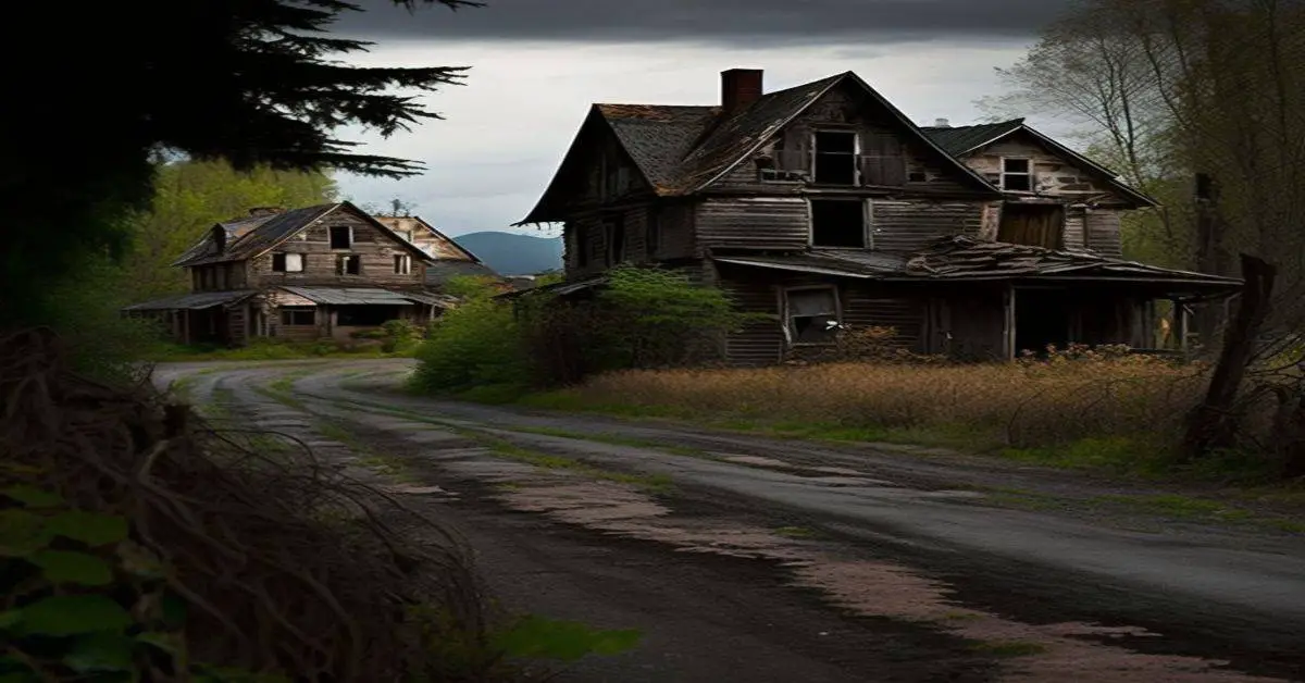
Garnet is a ghost town in Granite County, Montana, United States. Located on the dirt Garnet Range Road, it is an abandoned mining town that dates from the 1860s. In First Chance Gulch in western Montana, the town is located 11 miles up the Garnet Range Road, in mountains and forest. The town is at about 6,000 feet (1,800 m) elevation.
Remains:
Garnet was originally named Mitchell in 1895 and had ten buildings. The main part of the town was built on the Garnet Lode. Later changing its name to Garnet, it was a rich gold mining area. In 1898, as many as 1,000 people lived here; it was abandoned 20 years later when the gold ran out. A fire in 1912 destroyed half the town, which was never rebuilt. Supplies needed in Garnet were generally obtained from nearby Bearmouth.
Current Status:
Garnet has the Wells hotels, Kelly Saloon, Daveys Store, and many outer buildings, preserved and intact. During the 1890s, it had close to thirteen saloons (bars), as well as food stores, a barbershop, a mercantile store, and three hotels. The hotels were started for passersby, or people coming to pick up gold. They typically ranged from 1-3 dollars, and the poor miners who could not afford that price could sleep in the attic without any windows for a quarter. It is suspected that Garnet even had a brothel, but prices and the exact whereabouts are uncertain. Garnet was famous for its saloons; at its peak, the saloons were one of the hottest spots in Garnet.
Remarks:
Despite this, Garnet is one of the state’s best-preserved with 16,000 visitors annually. The annual celebration on the third Saturday of each year is Garnet Day. Garnet’s oldest living member, Mary Jane Adams Morin, came to visit every year. The nearest city is Missoula, about 20 miles (32 km) to the west. The closest city to the east is Butte, about 100 miles (160 km) away.
Giltedge, MT
County:
Fergus
Zip Code:
Latitude / Longitude:
Elevation:
Time Zone:
Mountain (MST) (UTC-7)
Established:
Disestablished:
Comments:
Remains:
Current Status:
Remarks:
Glendale, MT
County:
Beaverhead
Zip Code:
Latitude / Longitude:
Elevation:
Time Zone:
Mountain (MST) (UTC-7)
Established:
Disestablished:
Comments:
Remains:
Current Status:
Remarks:
Gold Creek, MT
County:
Powell
Zip Code:
Latitude / Longitude:
46°35’12N 112°55’43W
Elevation:
Time Zone:
Mountain (MST) (UTC-7)
Established:
Disestablished:
Comments:
In 1858, prospectors James and Granville Stuart and Reese Anderson discovered gold in the creek. The three men didn’t have sufficient tools to begin excavating and were unable to return with the proper equipment until 1862. The creek was renamed “Gold Creek” because of the gold found there. The Stuart brothers and their prospecting party helped open up Western Montana to settlers, all due to their initial find at Gold Creek. Gold Creek is near where the last spike of the Northern Pacific Railway was driven on September 8, 1883.
Remains:
Current Status:
Remarks:
Granite, MT
County:
Granite
Zip Code:
Latitude / Longitude:
46° 18′ 57.6 N, 113° 14′ 38.4 W
Elevation:
7,001 ft (2,134 m)
Time Zone:
Mountain (MST) (UTC-7)
Established:
unspecified
Disestablished:
Comments:
Granite is a ghost town in Granite County, Montana, United States, east of the town of Philipsburg.
Remains:
In 1872, Eli Holland found a small quantity of high-quality ruby silver in the area. A shallow shaft was dug but later abandoned until 1877, when Charles McLure discovered some silver ore in the shaft. He later traveled to St. Louis to obtain the capital necessary to begin the development of the mine.
Current Status:
Granite thrived as a silver mining town in the 1890s but is now completely deserted. The state of Montana maintains the mine superintendent’s house and the ruins of the union hall as Granite Ghost Town State Park.
Remarks:
Granite eventually grew into a town with more than 3,000 inhabitants. For the time period, there were many modern amenities, such as the large Miners Union Hall, a library, 18 saloons, brothels, a hospital, and a school as well as churches. The Sherman Silver Purchase Act was repealed in 1893, drastically lowering the price of silver, and many residents left Granite, leaving only 140 residents a year later. Granite is currently entirely uninhabited.
Hassel, MT
County:
Broadwater
Zip Code:
Latitude / Longitude:
Elevation:
Time Zone:
Mountain (MST) (UTC-7)
Established:
Disestablished:
Comments:
Remains:
Current Status:
Remarks:
Hecla, MT
County:
Beaverhead
Zip Code:
Latitude / Longitude:
45° 36′ 19.73 N, 112° 55′ 53.12 W
Elevation:
Time Zone:
Mountain (MST) (UTC-7)
Established:
Disestablished:
Comments:
Hecla was a town in Beaverhead County, Montana. It has been designated as a ghost town with only a few ruined buildings remaining. It was notable at one time as the home of Blanche Lamont, who taught at Hecla’s one-room schoolhouse. Lamont would become the first of two murder victims of Theodore Durrant. Margaret Brown also lived there for a time.
Remains:
The Hecla Mining District was “on the side of Lion Mountain. Also referred to as the Glendale and/or Bryant Mining District, which was strung out along ten miles of gulches, the four towns included Trapper City, Lion City, Glendale, and Hecla.” In 1881, the Hecla Company reorganized and came under the direction of Henry Knippenberg. Shortly after he assumed control, Knippenberg had the town of Hecla built a mile away from Lion City … Transportation from the mine was improved with the construction of a four-mile-long, narrow-gauge tramway from Hecla to the mill.
Current Status:
The General Merchandise operations in Hecla, run by H.W. Kappes, were “absorbed by the Hecla Mercantile & Banking Company in 1886. The Hecla Mercantile was a subsidiary of the Hecla Consolidated Mining Company based out of Glendale, Montana.” The area “was hard hit when the Sherman Silver Purchase Act was repealed in 1893.” “The district can be reached from I-15 near Melrose at Exit 93 on Trapper Creek Road. Glendale is about five miles and Lion City and Hecla, another 7 miles or so. A four-wheel drive or ATV is recommended.”
Remarks:
The town of Hecla grew to some 1,500 to 1,800 persons, with a waterworks system, fire protection, a church, a school for 200 pupils, and other businesses typical of a small mining camp.
Hesper, MT
County:
Yellowstone
Zip Code:
59106
Latitude / Longitude:
45°44’30N 108°42’31W
Elevation:
3,327 ft (1,014 m)
Time Zone:
Mountain (MST) (UTC-7)
Established:
1917
Disestablished:
Comments:
Hesper is an unincorporated community in Western Yellowstone County, Montana, United States. It is located Northeast of Laurel and west of Billings. The elevation is 3,327 feet (1014 m..) Hesper appears on the Mossmain U.S. Geological Survey Map.
Remains:
Hesper was established in 1917 as a town adjoining the Hesper ranch & also the name of the school district. The name Hesper or Hesperus is the evening star, & according to old mythology, the king of the western land. The name has Masonic roots. The community is named after the Hesper Farm, founded by Ignatius Daniel O’Donnell. In its heyday, the depot in Hesper served as a hub for surrounding farms and ranchers in the area. However, by the 1940s the town began to lose importance and declined.
Current Status:
Most of the original township itself is no longer in use, with many of the original structures leveled or abandoned. The community is home to the Yellowstone Boys and Girls Ranch and is now considered a subdivision of the Billings Metro Area.
Remarks:
The former Hesper School District is currently the Elder Grove Elementary School District and is still in operation to date, serving grades Kindergarten through Eighth.
Hillsboro, MT
County:
Big Horn
Zip Code:
Latitude / Longitude:
Elevation:
Time Zone:
Mountain (MST) (UTC-7)
Established:
Disestablished:
Comments:
Remains:
Current Status:
Remarks:
Hughesville, MT
County:
Judith Basin
Zip Code:
Latitude / Longitude:
Elevation:
Time Zone:
Mountain (MST) (UTC-7)
Established:
Disestablished:
Comments:
Remains:
Current Status:
Remarks:
Independence, MT
County:
Pitkin
Zip Code:
Latitude / Longitude:
39°6′23″N 106°36′19″W / 39.10639°N 106.60528°W / 39.10639
Elevation:
Time Zone:
Mountain (MST) (UTC-7)
Established:
1880s
Disestablished:
Comments:
Independence is a ghost town in the U.S. state of Colorado. It is located just off State Highway 82 in the eastern corner of Pitkin County, below the Continental Divide. It was the first settlement established in the Roaring Fork Valley, after gold was struck in the vicinity on Independence Day, July 4, 1879, hence its name.
Remains:
In 1973 it was recognized as a historic district and listed on the National Register of Historic Places as Independence and Independence Mill Site, one of two ghost towns in the county so recognized. It has also been known historically by other names—Chipeta, Mammoth City, Mount Hope, Farwell, Sparkill, and Hunter’s Pass.
Current Status:
It has been a ghost town since at least 1912. The remaining structures, all log cabins of various sizes, are now on land partially in White River National Forest. It is one of the few abandoned mining camps in the state where any buildings are left. In the late 20th century they were restored and interpretive materials added.
Remarks:
Like other early settlements in the upper Roaring Fork Valley, it lost population over the course of the decade as Aspen emerged as the ideal location for commerce in the region, and then became the county seat. It was never able to overcome the severe winters that resulted from its location at a high elevation in the mountains, and at the end of the 19th century all but one of the remaining residents abandoned Independence en masse after a particularly heavy snowstorm to settle in Aspen.
Ingomar, MT
County:
Rosebud
Zip Code:
Latitude / Longitude:
46° 34′ 36 N, 107° 22′ 20 W
Elevation:
Time Zone:
Mountain (MST) (UTC-7)
Established:
Disestablished:
Comments:
Ingomar is a small unincorporated community in northwestern Rosebud County, Montana, United States, along the route of U.S. Route 12. The town was established in 1908, as a station stop on the Chicago, Milwaukee, St. Paul, and Pacific Railroad, then under construction in Montana.
Remains:
Although the land around Ingomar attracted numerous homesteaders during the decade following the railroad’s completion, the region proved to be far too arid and inhospitable for intensive agricultural use, and by the 1920s the town was in decline.
Current Status:
The railroad through the area was abandoned in 1980, and only a handful of people remain in Ingomar today. Three of the town’s surviving buildings: the Ingomar Public School, J. A. Bookman General Store, and Wiley, Clark & Greening Bank have been listed on the National Register of Historic Places.
Remarks:
Jardine, MT
County:
Park
Zip Code:
Latitude / Longitude:
45° 4′ 12 N, 110° 38′ 4 W
Elevation:
Time Zone:
Mountain (MST) (UTC-7)
Established:
Disestablished:
Comments:
Jardine is a small, unincorporated village in Park County, Montana, USA. The town lies just to the north of Gardiner on inactive travertine terraces, much like those at Mammoth Hot Springs in nearby Yellowstone National Park. The town’s chief industry was a gold mine.
Remains:
Current Status:
Remarks:
Kendall, MT
County:
Hamilton
Zip Code:
67857
Latitude / Longitude:
37°56′05″N 101°32′46″W / 37.93472°N 101.54611°W / 37.93472
Elevation:
3,140 ft (960 m)
Time Zone:
Central (CST) (UTC-6)
Established:
Disestablished:
Comments:
Kendall is an unincorporated community in Hamilton County, Kansas, United States. Kendall is located near U.S. Route 50 and U.S. Route 400 12 miles (19 km) southeast of Syracuse. Kendall has a post office with ZIP code 67857.
Remains:
The frontiersman Charles “Buffalo” Jones, who in 1879 had co-founded Garden City, left from Kendall in 1886 on a hunt to try to capture remaining buffalo to prevent their looming extinction.
Current Status:
Remarks:
Keystone, MT
County:
Mineral
Zip Code:
Latitude / Longitude:
Elevation:
Time Zone:
Mountain (MST) (UTC-7)
Established:
Disestablished:
Comments:
Remains:
Current Status:
Remarks:
Kirkville, MT
County:
Granite
Zip Code:
Latitude / Longitude:
Elevation:
Time Zone:
Mountain (MST) (UTC-7)
Established:
Disestablished:
Comments:
Remains:
Current Status:
Remarks:
Landusky, MT
County:
Phillips
Zip Code:
Latitude / Longitude:
Elevation:
Time Zone:
Mountain (MST) (UTC-7)
Established:
Disestablished:
Comments:
Remains:
Current Status:
Remarks:
Laurin, MT
County:
Madison
Zip Code:
Latitude / Longitude:
Elevation:
Time Zone:
Mountain (MST) (UTC-7)
Established:
Disestablished:
Comments:
Remains:
Current Status:
Remarks:
Lennep, MT
County:
Yellowstone
Zip Code:
59053
Latitude / Longitude:
46°24’58N 110°32’35W
Elevation:
5,248 ft (1,600 m)
Time Zone:
Mountain (MST) (UTC-7)
Established:
Disestablished:
Comments:
Lennep is a ghost town and populated place in Meagher County, Montana.
Remains:
Lennep had a Lutheran church, general store, and post office. Located at the foot of the Castle Mountains, Lennep was once a station on the Old Milwaukee Road. The Lennep Mercantile housed the post office from the time the Mercantile opened in 1914; the post office had first opened in 1903 in a log home across the street. The post office was closed down in 1962.
Current Status:
Today Lennep is an abandoned, with a number of buildings remaining and in reasonable condition, including the old church and store. There are still residences in the vicinity of Lennep, but the townsite itself is unoccupied.
Remarks:
Leroy, MT
County:
Blaine
Zip Code:
Latitude / Longitude:
Elevation:
Time Zone:
Mountain (MST) (UTC-7)
Established:
Disestablished:
Comments:
Remains:
Current Status:
Remarks:
Limestone, MT
County:
Stillwater
Zip Code:
59061
Latitude / Longitude:
45°28’41N 109°54’07W
Elevation:
5,535 ft (1,687 m)
Time Zone:
Mountain (MST) (UTC-7)
Established:
Disestablished:
Comments:
Limestone is a Ghost Town located in Stillwater County, Montana. The elevation is 5,535 feet. Limestone appears on the Meyer Mountain U.S. Geological Survey Map.
Remains:
Limestone was a mining community situated along Lodgepole Creek and sat at the foot of Limestone Butte, for which the town was named. The town was small but busy. The post office operated at Limestone from 1910 to 1953.
Current Status:
Today Limestone is a ghost town with a number of buildings left standing, including the former grocery store and post office.
Remarks:
Lion City, MT
County:
Beaverhead
Zip Code:
Latitude / Longitude:
Elevation:
Time Zone:
Mountain (MST) (UTC-7)
Established:
Disestablished:
Comments:
Lion City is an unincorporated community in Beaverhead County.
Remains:
Current Status:
Remarks:
Lonetree, MT
County:
Chouteau
Zip Code:
Latitude / Longitude:
47°32’30N 110°17’03W
Elevation:
Time Zone:
Mountain (MST) (UTC-7)
Established:
1885
Disestablished:
Comments:
Lonetree (also Lone Tree or Steele) is a ghost town in Chouteau County, Montana, United States. Founded around 1885
Remains:
For nearly thirty years it possessed a post office, which was opened under the name of Steele on March 9, 1888; its name was changed to Lonetree on May 15, 1914. It bore this name for less than a year before closing on March 31, 1915.
Current Status:
The entire community of Lonetree was added to the National Register of Historic Places on September 11, 1980.
Remarks:
Maiden, MT
County:
Fergus
Zip Code:
Latitude / Longitude:
Elevation:
Time Zone:
Mountain (MST) (UTC-7)
Established:
Disestablished:
Comments:
Remains:
Current Status:
Remarks:
Mammoth, MT
County:
Madison
Zip Code:
Latitude / Longitude:
Elevation:
Time Zone:
Mountain (MST) (UTC-7)
Established:
Disestablished:
Comments:
Remains:
Current Status:
Remarks:
Marysville, MT
County:
Lewis & Clark
Zip Code:
Latitude / Longitude:
46°45’02N 112°18’01W
Elevation:
5,413 ft (1,650 m)
Time Zone:
Mountain (MST) (UTC-7)
Established:
1876
Disestablished:
Comments:
Marysville is a small unincorporated community in Lewis and Clark County, Montana, United States. In the 1880s and 1890s, it was a bustling mining town of three thousand residents and was the center of gold mining in Montana. The town was named by Thomas Cruise, mine owner, to honor Mary Ralston the wife of a miner.
Remains:
Much of the lore in Marysville was centered on one Irishman, “Irish Tommy” Cruise. He would come here to look for gold but would return with an empty poke and a smile. He didn’t have much money and often slept in a bar counter in Helena. One day, in a site near present-day Marysville, he hit it rich. He named the site Drumlummon, after his birthplace in Ireland, and founded Marysville. Some believe it was named so because the first person there was Mary Ralston. Others believed it was for the first three Mary’s there. Also, another said it was after one of Tommy’s associates. Tommy got $150,000 before selling it for $1,500,000.
Current Status:
Just up the dirt road is the Great Divide Ski Area, while down the road is the Silver City Saloon on Highway 279. In 2010, there were news reports stating that recent exploration of the richest gold mine in the area, the Drumlummon Mine, has led to possible new discoveries. Its lower levels were allowed to flood when the mine was closed in 1904 during litigation. Sentiment in the town is mixed regarding the possible resumption of extensive mining operations.
Remarks:
Maudlow, MT
County:
Gallatin
Zip Code:
Latitude / Longitude:
46°06’28N 111°10’23W
Elevation:
4,409 ft (1,344 m)
Time Zone:
Mountain (MST) (UTC-7)
Established:
Disestablished:
Comments:
Maudlow is a small unincorporated community in northern Gallatin County, Montana, United States. The town was a station stop on the transcontinental main line of the Chicago, Milwaukee, St. Paul, and Pacific Railroad (“the Milwaukee Road”), and was a community center for a small number of area ranchers and homesteaders. Maudlow was named after a family member of Montana Railroad President, R. A. Harlow, Maud Harlow. The first postmaster of the town, George Dodge, shortened the name to Maudlow.
Remains:
The town is in a narrow valley alongside Sixteen Mile Creek and near the midpoint of Sixteen Mile Canyon. The canyon, also historically known as “Montana Canyon,” was considered a scenic highlight of the Milwaukee Road line.
Current Status:
The population of Maudlow was never large, and by the late 20th century only a handful of residents remained in the area. The railroad through Maudlow was abandoned in 1980, and Maudlow is now nearly a ghost town. It is part of the Bozeman, MT Micropolitan Statistical Area.
Remarks:
Melrose, MT
County:
Silver Bow
Zip Code:
Latitude / Longitude:
45° 37′ 55 N, 112° 41′ 4 W
Elevation:
Time Zone:
Mountain (MST) (UTC-7)
Established:
Disestablished:
Comments:
Melrose, Montana, once known as “Camp Creek”, had its early beginnings as a tiny stage stop along the Big Hole River that would eventually become a terminus for the railroad, a shipping and receiving point for the Hecla Consolidated Mining Company and Bryant Mining District, consisting of Hecla, Lion City, Greenwood, Norwood, and Glendale. The area along the Big Hole River was settled as early as 1870, three families shared the valley, Jefferson McCauley, John Stone, and William Bowe. In 1875, William Bowe bought out two squatters giving them a combined total of $250.00. William Bowe pre-empted 160 acres of land and subsequently added 80 acres of Desert land.
Remains:
William built himself a modest home in 1875 and later purchased a structure in Rocker which he moved to Camp Creek (later Melrose), establishing himself as a Stage Stop and Hotel Entrepreneur. On December 25, 1876, William was married to Lucina Phillips who had recently divorced Adam Fleser of whom “Fleser Mountain” was named. She brought four children from this marriage and settled with William Bowe in their Hotel/Stage Stop. Lucina was no stranger to greeting and caring for travelers as her ex-husband Adam also operated a tiny stage stop along the base of Mount Fleser. It is likely that the married couple mutually agreed to operate the stage stop together as Lucina could tend to the meals and needs of the traveler while Billy could provide stable and other services.
Current Status:
With the railroad nearing, William Bowe platted the Townsite of Camp Creek and named it “Melrose”. William Bowe began selling off lots of this newly platted town around 1880. Business houses and homes quickly sprang up as the railroad inched closer. Miners and their families arrived and went to work the mines of the Hecla Company, miles west of Melrose. Melrose Is situated on the Big Hole River and sits within Silverbow County, Montana. The only thing separating the two counties of Silverbow and Beaverhead is the Big Hole River which runs directly through town.
Remarks:
The arrival of the Utah Northern’s narrow gauge in the spring of 1881 made it possible and profitable for the Hecla Consolidated Mining Company to ship silver and lead bullion (once hauled out by wagon road) to the refineries for further smelting. Hauling ore by wagon was not only costly but time-consuming. The arrival of the railroad greatly reduced the costs and overhead of the company and improved profits, helping bring in the necessary supplies, machinery, and charcoal needed to supply the furnaces at Glendale. The railroad arrived at Melrose in the Spring of 1881, marking an end to an era of freighting for Melrose and the communities within the Bryant Mining District.
Minden, MT
County:
Meagher
Zip Code:
Latitude / Longitude:
46°15’23N 110°52’31W
Elevation:
5,230 ft (1,594 m)
Time Zone:
Mountain (MST) (UTC-7)
Established:
Disestablished:
Comments:
Minden is a ghost town in Meagher County, Montana, United States. Situated in the Crazy Mountains, Minden possessed a post office from 1896 to 1903 with Henry T. Foster as the postmaster and store owner.
Remains:
Current Status:
Remarks:
Mondak, MT
County:
Roosevelt
Zip Code:
Latitude / Longitude:
48°01’13N 104°02’50W
Elevation:
2,070 ft (630 m)
Time Zone:
Mountain (MST) (UTC-7)
Established:
1903
Disestablished:
1925
Comments:
Mondak, Montana is a ghost town in Roosevelt County, which flourished c. 1903-1919, in large measure by selling alcohol to residents of North Dakota, then a dry state.
Remains:
Mondak—a name derived from the adjoining states—was created in 1903, mostly by local investors who realized that profit could be made by selling beer and liquor to North Dakotans. Because of its strategic location on the Missouri River and the Great Northern Railway, Mondak quickly became a thriving village. The first building was constructed in 1904, and Mondak soon boasted a bank, two hotels, three general stores, and several grain elevators. It also eventually had a church, a newspaper, a two-story brick school, and a part-time electric generating plant. Locally raised grain and cattle were shipped to Minneapolis on the Great Northern, but the town’s most profitable business remained alcohol sales.
Current Status:
Mondak’s prosperity was short-lived. The area entered a drought cycle in 1916; and the Snowden Bridge, completed in 1913, reduced ferry traffic across Missouri. In 1916 a fire destroyed several saloons and a warehouse and badly damaged a hotel and a general store. In 1919 Montana instituted prohibition. Although Mondak was never entirely dry, prohibition “cramped Mondak’s style.” When the county seat, provisionally located in Mondak, moved to Poplar in 1920, Mondak’s decline accelerated. In early 1924, the railroad station closed, and the bank, the town’s last viable business, closed in 1925. In 1928 another fire destroyed many remaining buildings. The scant remains of the ghost town are on private property within a mile of Fort Union Trading Post National Historic Site and within two miles of Fort Buford State Historic Site, North Dakota.
Remarks:
During its heyday, Mondak had at least seven saloons and a number of warehouses to store alcohol. Gambling and prostitution were never legal but always winked at. There were many accidents involving inebriated men, and the crime rate was high for the size of the community. On April 4, 1913, a black construction worker killed Sheriff Thomas Courtney and a deputized citizen Richard Bermeister and was promptly lynched by the residents.
Nevada City, MT
County: Madison
Zip Code:
Latitude / Longitude: 45°18’27N 111°58’4.8W
Elevation: 5,761 ft (1,756 m)
Time Zone: Mountain (MST) (UTC-7)
Established:
Disestablished:
Comments: Nevada City /n’ved’sti/ (n-VAY-d) is an unincorporated community in Madison County, Montana, United States. In the 1880s, it was one of the two major centers of Commerce in what was known as one of the “Richest Gold Strikes in the Rocky Mountain West”, it shared that role with its sister city Virginia City. Since the late 1990s, Nevada City has become one of Montana’s biggest tourist attractions, as well as a largely residential area.
Remains: Archaeological evidence found between the Music Hall and the Nevada City Hotel would indicate earlier than mining era habitation, possibly by white hunters or trappers. The earliest white hunters and trappers in the area had no conscious intention of establishing a city on the site because the existence of a city would have presumably destroyed their economic base, which was based on the harvesting of beaver.
Current Status: Today, the town is managed by the Montana Heritage Commission, Department of Commerce, State of Montana. Businesses in the town are Alder Gulch Accommodations, Nevada City Hotel and Cabins, Just an Experience Bed and Breakfast, The Star Bakery, and the Nevada City Hotel Coffee Shop. Some of the businesses are operational year-round, others are operational during the summer season. The town has been restored as an outdoor living history historical museum, linked by railroad to the Virginia City Historic District with numerous historic buildings, artifacts, and furnishings. It is owned by the State of Montana and operated by the Montana Heritage Commission, with 108 historic buildings from various places around Montana, 14 original Nevada City structures.
Remarks: Nevada City is also home to North America’s largest collection of automated music machines which can be found in the Nevada City Music Hall (“Nevada City.”). The Bovey’s have been collecting the machines since 1940 and many of the machines are in excellent working condition (“Nevada City.”). On December 19, 1863, a miners’ court trial took place. The trial was for the murder of Nicholas, a Dutchman. George Ives was convicted and in less than an hour, he was hanged in the middle of town while nearly 2,000 residents watched (“Nevada City, Montana.”). According to Blumenthal, when the mining had come to an end in 1922, about $2.5 billion worth of gold in today’s market had been extracted (Blumenthal 2). Nevada City is about 27 miles southeast of Twin Bridges, Montana on Highway 287. The townsite is located 1½ miles west of Virginia City, Montana on Hwy 287.