Oakland, TX
County:
Colorado
Zip Code:
78951
Latitude / Longitude:
29°36’06″N 96°49’48″W
Elevation:
167 ft (51 m)
Time Zone:
Central (CST) (UTC-6)
Established:
Disestablished:
Comments:
Oakland is an unincorporated community in Colorado County, Texas, United States. According to the Handbook of Texas, the community had an estimated population of 80 in 2000. It is located southwest of Weimar on Farm to Market Road 532 (FM 532) near its junction with Farm to Market Road 2144 (FM 2144).
Remains:
Although it is unincorporated, Oakland has a post office, with the ZIP code of 78951. Public education in the community is provided by the Weimar Independent School District.
Current Status:
According to the Geographic Names Information System (GNIS), Oakland is situated at 29°36’06″N 96°49’48″W. The community is located 10.7 miles (17.2 km) southwest of Weimar via FM 532 and Farm to Market Road 155 (FM 155). The intersection of FM 532 with FM 2144 is a short distance to the northeast of Oakland. By using FM 2144, which connects with FM 155, the distance to Weimar is a slightly longer 10.9 miles (17.5 km). The Navidad River flows south on the west side of Oakland. Its two branches, the East and West Navidad Rivers join a short distance to the northwest of the community.
Remarks:
Ochoa, TX
County:
Presidio
Zip Code:
Latitude / Longitude:
Elevation:
Time Zone:
Central (CST) (UTC-6)
Established:
Disestablished:
Comments:
Remains:
Current Status:
Remarks:
O’Daniel, TX
County:
Guadalupe
Zip Code:
Latitude / Longitude:
Elevation:
Time Zone:
Central (CST) (UTC-6)
Established:
Disestablished:
Comments:
Remains:
Current Status:
Remarks:
Odds, TX
County:
Falls
Zip Code:
Latitude / Longitude:
Elevation:
Time Zone:
Central (CST) (UTC-6)
Established:
Disestablished:
Comments:
Remains:
Current Status:
Remarks:
Ohio, TX
County:
Hamilton
Zip Code:
Latitude / Longitude:
31° 32′ 22″ N, 98° 5′ 10″ W
Elevation:
Time Zone:
Central (CST) (UTC-6)
Established:
Disestablished:
Comments:
Ohio is an unincorporated community in Hamilton County, in the U.S. state of Texas.
Remains:
A post office called Ohio was established in 1882, and remained in operation until 1920. The community was named after the state of Ohio. Little remains of the original town.
Current Status:
Remarks:
Ojo de Veranda, TX
County:
Presidio
Zip Code:
Latitude / Longitude:
Elevation:
Time Zone:
Central (CST) (UTC-6)
Established:
Disestablished:
Comments:
Remains:
Current Status:
Remarks:
Old Gomez, TX
County:
Terry
Zip Code:
Latitude / Longitude:
Elevation:
Time Zone:
Central (CST) (UTC-6)
Established:
Disestablished:
Comments:
Remains:
Current Status:
Remarks:
Olga, TX
County:
Nolan
Zip Code:
Latitude / Longitude:
Elevation:
Time Zone:
Central (CST) (UTC-6)
Established:
Disestablished:
Comments:
Remains:
Current Status:
Remarks:
Olive, TX
County:
Hardin
Zip Code:
Latitude / Longitude:
Elevation:
Time Zone:
Central (CST) (UTC-6)
Established:
Disestablished:
Comments:
Remains:
Current Status:
Remarks:
Olmos, TX
County:
Guadalupe
Zip Code:
Latitude / Longitude:
Elevation:
Time Zone:
Central (CST) (UTC-6)
Established:
Disestablished:
Comments:
Remains:
Current Status:
Remarks:
Orient, TX
County:
Tom Green
Zip Code:
Latitude / Longitude:
Elevation:
Time Zone:
Central (CST) (UTC-6)
Established:
Disestablished:
Comments:
Remains:
Current Status:
Remarks:
Orla, TX
County:
Reeves
Zip Code:
Latitude / Longitude:
31°49’30″N 103°54’32″W
Elevation:
Time Zone:
Central (CST) (UTC-6)
Established:
Disestablished:
Comments:
Orla is a ghost town in Reeves County, Texas, United States. It lies about 38 miles north of Pecos. It is believed to have two residents and has its own post office, located on U.S. Route 285. The post office was established 26 December 1906 with Joshua D. McAdams as first postmaster.
Remains:
Orla was founded in 1890 and served as a section house for the newly built Pecos Valley Railroad, incorporated by John J. Hagerman, an American Industrialist, to link Eddy, New Mexico (now Carlsbad) with Pecos, Texas. The population remained small until World War II when the town’s population finally grew and the number of businesses increased to two to serve the population of nearly 60 residents. The population reached a high of around 250 people when oil, gas, and sulphur activity brought more workers to the region in the 1960s.
Current Status:
Remarks:
Orlena, TX
County:
Cooke
Zip Code:
Latitude / Longitude:
Elevation:
Time Zone:
Central (CST) (UTC-6)
Established:
Disestablished:
Comments:
Remains:
Current Status:
Remarks:
Osage, TX
County:
Colorado
Zip Code:
78962
Latitude / Longitude:
29°44’28″N 96°42’54″W
Elevation:
325 ft (99 m)
Time Zone:
Central (CST) (UTC-6)
Established:
Disestablished:
Comments:
Osage is a ghost town in northwestern Colorado County in the U.S. state of Texas. The one-time settlement was situated on Harvey Creek near the junction of County Roads 205 and 208 a few miles to the northeast of Weimar. At the time of the American Civil War, the community was substantial enough to provide a company of soldiers to a Texas regiment in the Confederate States Army. A notable school flourished in Osage starting in the 1870s, but in that decade the railroad was built through Weimar instead. By 1900 the local commercial establishments had moved to Weimar and the town faded out of existence. In 2013 the area was sparsely settled.
Remains:
The Geographic Names Information System (GNIS) places the Osage Cemetery at 29°44’28″N 96°42’54″W which is near the intersection of County Roads 205 and 208 in Colorado County. This location is 6.2 miles (10.0 km) northeast of the center of Weimar via FM 155 and County Roads 202, 204, 201 and 208. The Colorado River flows a few miles to the north and east. The only other landmarks in the area are the Old Osage Cemetery a few hundred yards to the northeast of the Osage Cemetery and the Adkins Cemetery on County Road 201.
Current Status:
Remarks:
Otis Chalk, TX
County:
Howard
Zip Code:
Latitude / Longitude:
Elevation:
Time Zone:
Central (CST) (UTC-6)
Established:
Disestablished:
Comments:
Remains:
Current Status:
Remarks:
Owens, TX
County:
Crosby
Zip Code:
Latitude / Longitude:
Elevation:
Time Zone:
Central (CST) (UTC-6)
Established:
Disestablished:
Comments:
Remains:
Current Status:
Remarks:
Owensville, TX
County:
Robertson
Zip Code:
Latitude / Longitude:
31°04’23″N 96°31’10″W
Elevation:
489 ft (149 m)
Time Zone:
Central (CST) (UTC-6)
Established:
Disestablished:
Comments:
Owensville is a former community in Robertson County, Texas, United States. Owensville was located on Farm to Market Road 46 five miles northwest of Franklin.
Remains:
Owensville was chosen as the site of Robertson County’s county seat in 1855, and county records were moved from Wheelock to the courthouse in Owensville in 1856. County officials named Owensville after Harrison Owen, the first county clerk of Robertson County. A post office opened in Owensville along with the courthouse in 1856. Owensville quickly expanded and was the county seat through the Civil War, but railroads in the region bypassed the community. During Reconstruction, county judge I.B. Ellison declared Calvert the new county seat, and county records were moved from Owensville to Calvert in 1870. After Owensville lost the county seat, it rapidly declined. The post office closed in 1872, though it briefly reopened from 1895 to 1897.
Current Status:
By 1990, all that remained in Owensville was a cemetery.
Remarks:
Owenville, TX
County:
Sutton
Zip Code:
Latitude / Longitude:
Elevation:
Time Zone:
Central (CST) (UTC-6)
Established:
Disestablished:
Comments:
Owenville was a ghost town in Sutton County, Texas, United States. The community’s elevation and geographic coordinates are unknown, as nothing remains of the town.
Remains:
Current Status:
Remarks:
Padgett, TX
County:
Young
Zip Code:
Latitude / Longitude:
Elevation:
Time Zone:
Central (CST) (UTC-6)
Established:
Disestablished:
Comments:
Remains:
Current Status:
Remarks:
Palm Valley, TX
County:
Williamson
Zip Code:
Latitude / Longitude:
30°32’36″N 97°37’16″W
Elevation:
709 ft (216 m)
Time Zone:
Central (CST) (UTC-6)
Established:
Disestablished:
Comments:
Palm Valley is a formerly independent community on US Route 79, now incorporated into Round Rock, in the county of Williamson, in the U.S. state of Texas.
Remains:
The community was named for its founder, Swedish settler Anna Palm, a widow with six sons, who arrived in 1853. The family lived in tents, and eventually built a house. The Palm family was shortly followed by other Swedish immigrants. The Palm Valley Lutheran Church was built in 1872 and doubled as a schoolhouse. In 1970, the church was designated a Recorded Texas Historic Landmark. Anna’s son Andrew J. Palm built his own home in 1873. The house was moved to Round Rock in 1976. Two years later the home was also designated a Recorded Texas Historic Landmark and is open to the public as the Palm House Museum. During its populous years, Palm Valley was primarily a Swedish community. It has since become a ghost town.
Current Status:
Remarks:
Pandale, TX
County:
Val Verde
Zip Code:
78840
Latitude / Longitude:
30°11’4″N 101°33’3″W
Elevation:
1,650 ft (503 m)
Time Zone:
Central (CST) (UTC-6)
Established:
Disestablished:
Comments:
Pandale is a ghost town in Val Verde County, Texas, United States. It is a small town whose current population is smaller than in some previous years. It has been noted as a starting point for canoeing expeditions.
Remains:
Pandale is located in Val Verde County at the conjunction of Texas Ranch to Market Road 1024 and the Langtry-Pandale Rd., an unpaved caliche county road. It is located on the Pecos River. The town can also be reached from Interstate 10 via Texas Ranch to Market Road 2083, which becomes unpaved heading south at the Crockett/Val Verde County line. RM 2083 heads southwest from Ozona to the town of Pandale. The population in 2000 was 20. The permanent population has increased slightly due to ranch subdivisions and consists mainly of retirees. However, during the annual November to January deer hunting season, there is a huge influx of hunters, the vast majority of whom own hunting leases on small tracts of private property, usually consisting of raised hunting blinds located in close proximity to stocked, timed release corn and protein feeders.
Current Status:
Prehistoric people lived in the area and left relics, such as arrowheads, one of which is called a “Pandale”. The name of Pandale originates from its pan-like shape (pan) location in a valley (dale). The town began as a settlement where a crossing was established on the Pecos River. Around 1928, the town became a ranching community. There was once a school in the town but it closed when the school district was consolidated with the Comstock Independent School District in 1969. There is currently one small general store open part-time, and a cabin lodge near the Pecos River crossing, called Pandale Crossing River Resort. There is no longer a post office in the town.
Remarks:
Structures in Pandale consist of a two-story stone house once owned by Henry James Young Mills, an out building that was formerly a garage and general store, also owned by the Mills family and a single room school house which was also used for Sunday school.
Pandora, TX
County:
Wilson
Zip Code:
Latitude / Longitude:
29° 15′ 1″ N, 97° 50′ 16″ W
Elevation:
Time Zone:
Central (CST) (UTC-6)
Established:
Disestablished:
Comments:
Pandora is an unincorporated community in Wilson County, Texas, United States.
Remains:
It is located at the junction of U.S. Highway 87 and FM 1107 in eastern Wilson County. This is approximately 20 miles northeast of Floresville and 46 miles southeast of Downtown San Antonio. Although it is unincorporated, Pandora has a post office, with the ZIP code of 78143.
Current Status:
According to the Handbook of Texas, the community had an estimated population of 125 in 2000. Pandora is part of the San Antonio Metropolitan Statistical Area.
Remarks:
Park Springs, TX
County:
Wise
Zip Code:
Latitude / Longitude:
Elevation:
Time Zone:
Central (CST) (UTC-6)
Established:
Disestablished:
Comments:
Remains:
Current Status:
Remarks:
Parris, TX
County:
Collin
Zip Code:
75454
Latitude / Longitude:
33°15’10″N 96°36’21″W
Elevation:
551 ft (168 m)
Time Zone:
Central (CST) (UTC-6)
Established:
Disestablished:
Comments:
Parris, Texas is a community that once existed just south of Melissa in central Collin County near the banks of the East Fork of the Trinity River.
Remains:
In 1859 Thaddeus Parris, a Mexican–American War veteran for whom the community was named built an ox-turned Gristmill at this location. This attracted settlers of the area during the next decade and until sometime in the late nineteenth or early twentieth century Parris remained a community center for area farmers.
Current Status:
Remarks:
Paso Real, TX
County:
Cameron
Zip Code:
Latitude / Longitude:
Elevation:
Time Zone:
Central (CST) (UTC-6)
Established:
Disestablished:
Comments:
Remains:
Current Status:
Remarks:
Peach Creek, TX
County:
Wharton
Zip Code:
77488
Latitude / Longitude:
29°20’8″N 95°56’58″W
Elevation:
49 ft (15 m)
Time Zone:
Central (CST) (UTC-6)
Established:
Disestablished:
Comments:
Peach Creek is a ghost town in Wharton County in the U.S. state of Texas. The former settlement was located along Peach Creek in the land grants belonging to Old Three Hundred settlers William Kincheloe and Alexander Jackson, Sr. During the Republic of Texas a post office was located at Peach Creek. Though it was hoped the community might become the county seat, that never happened and postal service stopped in 1847.
Remains:
Peach Creek rises west of Farm to Market Road 102 near Egypt. The stream flows generally southeast for a distance of 27 miles (43 km) until it empties into the San Bernard River 8 miles (13 km) southeast of Wharton. A published sketch map from Wharton County deed records placed the settlement along Peach Creek mostly within Kincheloe’s land grant and also a short distance into Jackson’s land grant to the north. This location is approximately between U.S. Route 59 on the west and County Road 135 (Junior College Blvd.) on the east.
Current Status:
When Republic of Texas was founded, a postal station was set up with Phillips as postmaster. In 1839 a second postal station was added at Kincheloe’s crossing with Alexander Jackson, Jr. as postmaster. The upper crossing was then in Colorado County and the lower crossing in Matagorda County. When Wharton County was established in 1846, Kincheloe’s family offered a location on Peach Creek as the county seat, but this was declined. On July 1, 1847, Peach Creek lost its post office and thereafter received its mail from the new county seat at Wharton.
Remarks:
William and Mary Betts Kincheloe moved to Texas in 1821. Two years later the Mexican census recorded William as being 44 years old and living with his wife and eight children. A blacksmith by trade, Kincheloe received a land grant of a league of land on July 8, 1824. He later donated the land on which the Wharton County courthouse stands and died in 1835. The east-west trail between Harrisburg and Texana and the north-south trail between Matagorda and San Felipe passed through the area. There were two crossings of Peach Creek; the upper crossing was located in Alexander Jackson’s league while the lower crossing was situated in Kincheloe’s league. Later the upper crossing became known as Kincheloe’s Crossing. The owner of the adjacent league to the south, Isham B. Phillips bought 177 acres for a house in Kincheloe’s league next to the lower crossing.
Peach Tree Village, TX
County:
Tyler
Zip Code:
Latitude / Longitude:
Elevation:
Time Zone:
Central (CST) (UTC-6)
Established:
Disestablished:
Comments:
Remains:
Current Status:
Remarks:
Pear Valley, TX
County:
McCulloch
Zip Code:
76852
Latitude / Longitude:
31°18’37″N 99°29’38″W
Elevation:
1,581 ft (482 m)
Time Zone:
Mountain (MST)Central (CST) (UTC-6) (UTC-7)
Established:
Disestablished:
Comments:
Pear Valley is an unincorporated community in McCulloch County, Texas, United States.
Remains:
Current Status:
According to the Handbook of Texas, the community had an estimated population of 37 in 2000.
Remarks:
Pedernales, TX
County:
Gillespie
Zip Code:
Latitude / Longitude:
30°12’33″N 98°56’39″W
Elevation:
Time Zone:
Central (CST) (UTC-6)
Established:
Disestablished:
Comments:
Pedernales, Texas was an early settlement of German immigrants in Gillespie County, and was part of the Adelsverein colonization of Texas. No trace of the settlement remains today. It is located 7 miles (11 km) southwest of Fredericksburg near what is now Texas State Highway 16. The Pedernales school received a Texas Historical Commission Subject Marker in 1993, Marker number 10095.
Remains:
In 1846, Wilhelm Victor Keidel moved to Fredericksburg, becoming Gillespie County’s first physician, and in 1848 the county’s first Chief Justice. He was one of the individuals who signed the petition to create Gillespie County On December 15, 1847.
Current Status:
On September 11, 1854, Keidel hosted a meeting to plan Live Oak School and was elected trustee. A decade later, Pedernales had its own school district, along with two stores and a cotton gin. The school supported grades 1 through 7, all taught by one teacher. The schoolhouse was of native limestone. Community activities centered on the school, and year-end exams were called “schulpruefung”, followed by a celebratory picnic. Private tuition and the state of Texas funded the school. Enrollment dipped during World War II, and the Pedernales school was consolidated in 1949 with the Wrede School, closer to Fredericksburg. The original school is now a private home, and nothing else remains of the settlement.
Remarks:
Keidel relocated 7 miles (11 km) southwest of Fredericksburg to the banks of the Pedernales River and founded a settlement he named Pedernales. For any settlers who would relocate with him to the settlement, he agreed to give them free medical care. Keidel became the first leader of the community. Among the other early residents were photographer and landscape artist Hermann Lungkwitz and his brother-in-law and fellow painter Friedrich Richard Petri. After the Bettina community failed circa 1848, Jacob Kuechler and his wife Marie Petri Kuechler moved to Pedernales, to join the family business. By 1850 the settlement had forty-four residents of German descent.
Penick, TX
County:
Travis
Zip Code:
Latitude / Longitude:
Elevation:
Time Zone:
Central (CST) (UTC-6)
Established:
Disestablished:
Comments:
Remains:
Current Status:
Remarks:
Perico, TX
County:
Dallam
Zip Code:
Latitude / Longitude:
36° 16′ 35″ N, 102° 51′ 52″ W
Elevation:
Time Zone:
Central (CST) (UTC-6)
Established:
Disestablished:
Comments:
Perico, once known as Farwell, is a ghost town on U.S. Route 87 in Dallam County, Texas, United States as well as home to the famous Ben Bezner. As late as 1980, the town had a business, a grain elevator and 16 known residents. Now all that stands is a few houses, old school, cattle and an old Catholic Church.
Remains:
Pescadito was a town near Laredo in southwestern Webb County, Texas, United States. Pescadito was a stop on the Texas Mexican Railway in 1881. In 1930 it had a population of 25. The community’s main business was mesquite wood for railroads until coal began to be used in 1946.
Current Status:
Remarks:
Pescadito, TX
County:
Webb
Zip Code:
Latitude / Longitude:
27° 30′ 38″ N, 99° 15′ 27″ W
Elevation:
Time Zone:
Central (CST) (UTC-6)
Established:
Disestablished:
Comments:
Remains:
Current Status:
Remarks:
Peyton Colony, TX
County:
Blanco
Zip Code:
Latitude / Longitude:
Elevation:
Time Zone:
Central (CST) (UTC-6)
Established:
Disestablished:
Comments:
Remains:
Current Status:
Remarks:
Phelan, TX
County:
Bastrop
Zip Code:
Latitude / Longitude:
Elevation:
Time Zone:
Central (CST) (UTC-6)
Established:
Disestablished:
Comments:
Remains:
Current Status:
Remarks:
Phillips, TX
County:
Hutchinson
Zip Code:
79007
Latitude / Longitude:
35° 41′ 14.71″ N, 101° 21′ 4″ W
Elevation:
Time Zone:
Central (CST) (UTC-6)
Established:
Disestablished:
Comments:
Phillips is a ghost town in Hutchinson County, United States. It was founded as Pantex, Texas. In 1938 Pantex and Whittenburg combined. The combined town was renamed Phillips for the dominant employer, the Phillips Petroleum Company by a vote of the people. The American actress Mary Castle lived in Phillips as a girl and attended junior high school there. State Senator and former president of West Texas A&M University Max Sherman was reared in Phillips and graduated from Phillips High School.
Remains:
A hydrocarbon explosion at the refinery in 1980 obliterated part of the industrial area and some nearby homes. Damages were estimated to be in the millions. After a long battle between the citizens of Phillips, M&M Cattle Company and later Phillips 66, the town was permanently closed to residency, at the request of Phillips 66 Oil Company. The homes themselves were owned but the land they sat upon was property of two local ranchers who leased the land originally to the Oil Company and later to the home owners. After the explosion, the Oil Company purchased the land from the ranches and forced the homeowners to move. Most would say the real reason the plant wanted the homeowners out of the area was not based on safety, but the fact the oil company was paying close to a million dollars a year in school taxes and wanted the school closed. But this is refuted as the taxes are paid to the Plemons-Stinnett-Phillips CISD. In 1987 three great schools and communities, Plemons, Stinnett and Phillips joined forces to create the Plemons-Stinnett-Phillips Consolidated independent School District. Three mascots, the Plemons Indians, Stinnett Rattlers and the Phillips Blackhawks were blended together to create the Comanches. The campuses of the district, West Texas Elementary School, West Texas Middle School and West Texas High School are all united as Comanches. Therefore, many homes were moved to areas nearby (Borger, Stinnett, and Fritch). The homes that were not moved were leveled.
Current Status:
Today, the high school is one of the few buildings left and is used for business by the Phillips 66 Refinery.
Remarks:
In the 1950s and 1960s, improved highways and transportation resulted in many businesses and people moving to Borger. By 1980, the population had dropped to about 2,500.
Pilares, TX
County:
Presidio
Zip Code:
Latitude / Longitude:
Elevation:
Time Zone:
Central (CST) (UTC-6)
Established:
Disestablished:
Comments:
Remains:
Current Status:
Remarks:
Pine Spring, TX
County:
Culberson
Zip Code:
Latitude / Longitude:
Elevation:
Time Zone:
Central (CST) (UTC-6)
Established:
Disestablished:
Comments:
Remains:
Current Status:
Remarks:
Pisek, TX
County:
Colorado
Zip Code:
77950
Latitude / Longitude:
29°55’00″N 96°34’59″W
Elevation:
291 ft (89 m)
Time Zone:
Central (CST) (UTC-6)
Established:
Disestablished:
Comments:
Pisek (or Lone Oak, Sandy Point, or Nickols) is a ghost town in northern Colorado County, in the U.S. state of Texas. The former settlement, now a ghost town, was abandoned after 1941 when the inhabitants moved to Lone Oak on Farm to Market Road 1291. The site of Pisek is on a railroad between Fayetteville in Fayette County and New Ulm in Austin County.
Remains:
Pisek was situated in extreme northern Colorado County near where the BNSF Railway crosses Fischer-Buller Road. Boggy Creek runs to the northwest through the site before turning southwest and emptying into Cummins Creek. Area roads include Lutonsky Lane, Buxkemper Road, 10th Street and Stokes Road to the northeast and Schmidt and Kickler Roads to the south. The junction of FM 1291 and Fischer-Buller Road is 1.1 miles (1.8 km) south of the railroad crossing. New Ulm is 7.7 miles (12.4 km) east of the junction of FM 1291 and Fischer-Buller Road, while Fayetteville is 5.8 miles (9.3 km) west of the same place.
Current Status:
About 3 miles (4.8 km) to the east, there is a state historical marker that commemorates Mary Theresa Hennecke Juergens. Mary and her husband Conrad came to Texas in 1833 and built a cabin. As Mexican armies invaded Texas during the Texas Revolution, most of the settlers fled the area in the Runaway Scrape. The Juergens family decided to stay but the pregnant Mary and her two stepsons were kidnapped by a band of Karankawa Indians. Mary gave birth in captivity and she and her daughter Ann Margaret were later ransomed for $300 at a trading post on the Red River. The boys were never recovered and Conrad soon died. Mary remarried and lived near Frelsburg until 1871 when she moved to Ohio. She died there in 1891.
Remarks:
The community called Pisek existed in the 1880s and boasted two commercial establishments. It was located where Lone Oak now exists, along FM 1291 roughly 3 miles (4.8 km) in each direction from the Fayette and Austin County lines. In 1887, when the Missouri, Kansas and Texas Railway completed its line to Boggy Tank and built a turntable at the site, the mostly Czech and German inhabitants of Pisek moved there. The railroad tried to name the new town Sandy Point, but eventually the name Pisek was adopted (after the Czech city of Pisek). Between 1896 and 1907 the community had a post office. During that period the settlement also had a saloon, cottonseed warehouse, and a few stores. While the town was a railhead it prospered, but after the railroad was completed to Houston, the residents began to move back to the original location. In 1941 the last store closed and moved away. The railroad renamed the site Nickols. The new community of Lone Oak was named for a single oak tree that stood near an important intersection. Its population was 50 in 2000.
Pittsville, TX
County:
Fort Bend
Zip Code:
Latitude / Longitude:
29° 43′ 23″ N, 95° 55′ 29″ W
Elevation:
Time Zone:
Central (CST) (UTC-6)
Established:
Disestablished:
Comments:
Pittsville is an unincorporated area that formerly held a distinct community in Fort Bend County, Texas, United States. The site is along Farm to Market Road 359 near Hunt Road north of Fulshear with Wyatt Resources Inc. located nearby. The last residents moved away in the 1940s, making Pittsville a ghost town. There is a Texas Historical Commission marker on the west side of FM 359 a short distance north of the intersection.
Remains:
Current Status:
Remarks:
Plata, TX
County:
Presidio
Zip Code:
79843
Latitude / Longitude:
29°52’34″N 104°01’3″W
Elevation:
3,780 ft (1,152 m)
Time Zone:
Central (CST) (UTC-6)
Established:
Disestablished:
Comments:
Plata is an unincorporated community in Presidio County, Texas, on Texas Farm Road 169 approximately 25 miles south of the county seat of Marfa.
Remains:
Current Status:
The population at the 2000 census was 37.
Remarks:
Pleasant Hill, TX
County:
Houston
Zip Code:
Latitude / Longitude:
31° 0′ 32″ N, 94° 47′ 52″ W
Elevation:
Time Zone:
Central (CST) (UTC-6)
Established:
Disestablished:
Comments:
Pleasant Hill, also known as Antrim, is a ghost town 10 miles northwest of present-day Grapeland in Houston County, Texas. The town’s school, one of the first in the county, was organized in 1864. After the local railroad was built, most residents moved to Grapeland, and the town was empty by 1900.
Remains:
Current Status:
Remarks:
Plemons, TX
County:
Hutchinson
Zip Code:
Latitude / Longitude:
35°48’03″N 101°18’33″W
Elevation:
2,739 ft (835 m)
Time Zone:
Central (CST) (UTC-6)
Established:
Disestablished:
Comments:
Plemons is a ghost town in Hutchinson County, in the U.S. state of Texas. It is located 10 miles southeast of Stinnett, and 8 miles (13 km) northeast of Borger, on Plemons Road, just north of the juncture of County Road R.
Remains:
In 1898, Oklahoma rancher James Andrew Whittenburg filed on four sections of land in Hutchinson County. There he built a dugout shelter near the Canadian River. He used the acreage as the family homestead. In 1901, Whittenburg donated acreage from the homestead land, for the establishment of Plemons. When Barney Plemons filed for land there, the town was named for him. Plemons became the county seat in 1901 when Hutchinson County was organized. E. E. Akers built the courthouse.
Current Status:
The Amarillo branch of the Rock Island and Gulf Railway bypassed Plemons, routing 10 miles (16 km) to the north. Stinnett was then developed to be a shipping point for the railroad. In 1926, the county seat of government was moved to Stinnett. Plemons began to decline after that, despite a brief spurt during the oil boom. Today Plemons is considered a ghost town.
Remarks:
Recorded Texas Historic Landmark Marker number 12096 was designated for the Plemons Cemetery. The first burial is believed to have been Mrs. E. E. Akers, date unknown. The last burial was Charles Ray Sessions in 1953. The local Boy Scouts troop spearheaded preservations efforts of the cemetery.
Plummer Crossing, TX
County:
Wilson
Zip Code:
Latitude / Longitude:
Elevation:
Time Zone:
Central (CST) (UTC-6)
Established:
Disestablished:
Comments:
Remains:
Current Status:
Remarks:
Poesta, TX
County:
Bee
Zip Code:
Latitude / Longitude:
Elevation:
Time Zone:
Central (CST) (UTC-6)
Established:
Disestablished:
Comments:
Remains:
Current Status:
Remarks:
Pontotoc, TX
County:
Mason
Zip Code:
Latitude / Longitude:
30°54’34″N 98°58’48″W
Elevation:
1,562 ft (476 m)
Time Zone:
Central (CST) (UTC-6)
Established:
Disestablished:
Comments:
Pontotoc is an unincorporated community on Pontotoc Creek, in northeastern Mason County, Texas, United States. The community is located at the junction of State Highway 71 and Ranch to Market Road 501.
Remains:
M. Robert Kidd, proprietor of the first general store and originally from Pontotoc, Mississippi, is said to have given the community and the creek their names. In 1859, Benjamin J. Willis was one of the first settlers in this community that was historically a junction of roads leading to San Saba from Fort Mason and from Llano. A small number of other families arrived in the same time period, establishing the community by 1878. Pontotoc included a hotel, general stores, mills, and businesses related to the horse industry. Agriculture products, cotton and pecans, helped support a community economy that also included wool and cattle.
Current Status:
Pontotoc had a local newspaper in 1906, and received its first telephone in 1914. A mica mining operation was begun in 1924. In 1941, Pontotoc had seven businesses. In 1947, a fire that began in the local theater swept through the town. Some of the structures were rebuilt, but the burned-out shells of the others stand today. Now, Pontotoc is a rural community with a small population.
Remarks:
In 1972, Recorded Texas Historic Landmark number 11294 was designated to acknowledge the 1883 establishment of the Pontotoc and San Fernando Academy. At its peak, the school had a student body enrollment of 200 for generalized education, or for achievement of teaching certificates. Principals were K. T. Hamilton and W. C. Roaten. With so much of the population decimated by the typhoid epidemic, the school went under in 1889. It was sold to the Pontotoc public school system, which used the academy as a public school until 1927. The ruins of the academy collapsed into rubble during a storm in 2016 The closing of the academy affected the local economy and was a factor in the decline of the population.
Porterville, TX
County:
Loving
Zip Code:
Latitude / Longitude:
Elevation:
Time Zone:
Central (CST) (UTC-6)
Established:
Disestablished:
Comments:
Porterville is a ghost town in Loving County, Texas, United States.
Remains:
Porterville was established in 1905 by Dr. Phil Porter, a physician who relocated from Michigan due to what he believed were health benefits of living in the desert. At one point in time, the town was a bustling community, with a hotel, a blacksmith’s shop, a post office, a doctor, and two general stores. Its population growth was initially fueled by inexpensive farmland and irrigation. However, the nearby Pecos River was not big enough to accommodate the needs of the farmers, and the population of the town declined precipitously. When oil was discovered in the early 1930s, the nearby town of Mentone was established, and the population of Porterville declined gradually until the town became abandoned.
Current Status:
Today, little remains of the former Porterville. The only building that still survives in any usable fashion is the town’s church, which was built in 1909 and moved to Mentone in 1931. The community’s elevation and geographic coordinates are unknown, as the town today is essentially a bare strip of local highway.
Remarks:
Port Sullivan, TX
County:
Milam
Zip Code:
Latitude / Longitude:
30° 51′ 58″ N, 96° 41′ 44″ W
Elevation:
Time Zone:
Central (CST) (UTC-6)
Established:
Disestablished:
Comments:
Port Sullivan, Texas is a ghost town in Milam County, Texas. It was established in 1835 by Augustus W. Sullivan. By the 1850s, Joseph P. Sneed, a pastor of the Methodist Episcopal Church, South, founded the Port Sullivan Male and Female Institute (also known as the Port Sullivan College). The town is home to the Port Sullivan Cemetery.
Remains:
Current Status:
Remarks:
Porvenir, TX
County:
Presidio
Zip Code:
Latitude / Longitude:
Elevation:
Time Zone:
Central (CST) (UTC-6)
Established:
Disestablished:
Comments:
Remains:
Current Status:
Remarks:
Praha, TX
County:
Newton
Zip Code:
Latitude / Longitude:
29° 40′ 12″ N, 97° 4′ 1″ W
Elevation:
Time Zone:
Central (CST) (UTC-6)
Established:
Disestablished:
Comments:
Praha is an unincorporated community located in Fayette County, Texas, United States, approximately 53 miles (85 km) southeast of Austin. Sometimes called “Maticka Praha”, which means “Mother Prague”.
Remains:
It was originally called Mulberry by the first Anglo settlers, James C. Duff, William Criswell and Leroy Criswell. (It was also known as Hottentot, a name which apparently referred to a band of local outlaws.)
Current Status:
During the Second World War Praha had the unfortunate distinction of being the U.S. town with largest ratio of war deaths to residents. The largest number of deaths occurred in 1944, when 9 soldiers from Praha were killed. Three small identical chapels were built in memory of the dead.
Remarks:
However, worshipers from the area continue to attend masses at the parish church, currently the town’s most notable feature. This spectacular Gothic structure was completed in 1892 and is the center of the annual Feast of the Assumption homecoming festival, which has been celebrated in Praha each August 15 since 1855. Locally known as “Praha Picnic”, the celebration draws as many as 5,000 visitors to its traditional Czech polka music and kolaches.
Preston, TX
County:
Grayson
Zip Code:
Latitude / Longitude:
Elevation:
708 ft (216 m)
Time Zone:
Central (CST) (UTC-6)
Established:
1836
Disestablished:
Comments:
Preston, also known as Preston Bend, is an unincorporated community and census-designated place located on the Red River in Grayson County, Texas, United States. It grew in the 19th century at the intersection of several military and trade roads and was an important crossing on the Shawnee cattle trail. Preston lost prominence after the MK&T railroad passed the town to the east, leading to a decline in traveler and cattle drive traffic. Much of its former town site is submerged beneath the waters of Lake Texoma.
Remains:
Before European settlement the general area of Preston had been occupied by the Caddo people, with the Comanche and Kiowa farther to the west. One of the first American settlers in the area was John Hart, who cultivated land at the bend in the Red River possibly before 1826. He left the area just after 1830 after being attacked by Indians during a trapping expedition on the Washita River.
Current Status:
Its population was 2,096 as of the 2010 census.
Remarks:
The current Preston CDP occupies the entire Preston Peninsula, bordered to the west by the main body of Lake Texoma and to the east by the Little Mineral Arm of the lake. The peninsula ends to the north at Preston Point, and the CDP extends south to the base of the peninsula, at Meadow Lake Drive to the east and at Highport Road to the west. Texas State Highway 289 has its northern terminus in Preston and leads south 7 miles (11 km) to Pottsboro. Denison is 14 miles (23 km) to the southeast, and Sherman, the Grayson County seat, is 20 miles (32 km) to the south-southeast.
Princeton, TX
County:
Newton
Zip Code:
Latitude / Longitude:
Elevation:
Time Zone:
Central (CST) (UTC-6)
Established:
Disestablished:
Comments:
Princeton is a ghost town in Newton County, Texas, United States, along the Sabine River.
Remains:
The town was located on the Sabine River near the site of Deweyville, about thirty miles northeast of Beaumont in southeastern Newton County. The site was platted in 1839 on Princeton Bluff (also known as Possum Bluff). It became a ferry and boat landing site for travelers on the Sabine River. A post office briefly opened from 1880 to 1881. The town never really grew in size and as Deweyville rose to prominence the town was abandoned around the turn of the 20th century.
Current Status:
Remarks:
Pringle, TX
County:
Hutchinson
Zip Code:
Latitude / Longitude:
35° 56′ 57″ N, 101° 27′ 23″ W
Elevation:
Time Zone:
Central (CST) (UTC-6)
Established:
Disestablished:
Comments:
Pringle is an unincorporated community in Northern Hutchinson County, Texas, United States.
Remains:
The Pringle-Morse Consolidated Independent School District serves area students.
Current Status:
Remarks:
Proffitt, TX
County:
Young
Zip Code:
Latitude / Longitude:
Elevation:
Time Zone:
Central (CST) (UTC-6)
Established:
Disestablished:
Comments:
Remains:
Current Status:
Remarks:
Provident City, TX
County:
Colorado
Zip Code:
77455
Latitude / Longitude:
29°16’58″N 96°37’56″W
Elevation:
141 ft (43 m)
Time Zone:
Central (CST) (UTC-6)
Established:
Disestablished:
Comments:
Provident City is a ghost town in the far southern panhandle of Colorado County in the U.S. state of Texas. The former settlement is located along County Road 190. The town was first settled through a land promotion scheme in 1909 and enjoyed a brief heyday. When it was obvious the hoped-for railroad would never come to town, people began moving away. The post office closed in 1953 and most of the land was bought up for ranching. The town no longer exists though the original hotel survives in private hands. Reaching the site requires driving 4.3 miles (6.9 km) on a gravel road from the nearest highway.
Remains:
The Geographic Names Information System (GNIS) locates Provident City at 29°16’58″N 96°37’56″W which is near the intersection of County Roads 190 and 248 in Colorado County. The former town is 26.0 miles (41.8 km) southeast of Hallettsville in Lavaca County via FM 530 and County Road 17. After County Road 17 crosses into Colorado County it becomes County Road 190 and intersects with Country Road 248 within a short distance.
Current Status:
In 1909 the Provident Land Company of Kansas City began heavily promoting land between Goldenrod Creek and Sandy Creek in Colorado County. As many as 500 families from the American Midwest bought five to ten acre plots, sight unseen. The company built hotels in Ganado and in Provident City to accommodate people interested in buying land in the area. By 1910, the town boasted banks, a broom factory, a cannery, churches, a drugstore, general and grocery stores, a jewelry store, restaurants, a school and an undertaker. That year a post office opened. The sandy local soil proved to be ideal for growing melons, cucumbers and other vegetables. The town counted 150 residents in 1914. By that year it was clear that a promised railroad connection would not materialize in the isolated place. During World War I people began to move to urban centers in search of higher wages. During the Great Depression many area farms were abandoned and lost through non-payment of taxes. By 1949 the population had sunk to 30 persons and the post office closed in 1953. Hancock Oil bought most of the property and converted it to ranching operations. By 1986 only the old hotel remained. One source lists Provident City among Texas ghost towns.
Remarks:
Pumpville, TX
County:
Val Verde
Zip Code:
Latitude / Longitude:
Elevation:
Time Zone:
Central (CST) (UTC-6)
Established:
Disestablished:
Comments:
Remains:
Current Status:
Remarks:
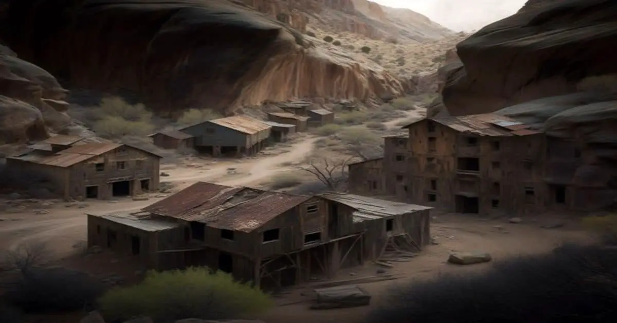
Pyote, TX
County: Ward
Zip Code: 79777
Latitude / Longitude: 31°32’15″N 103°7’36″W
Elevation: 2,625 ft (800 m)
Time Zone: Central (CST) (UTC-6)
Established:
Disestablished:
Comments: Pyote (/’pa”o”t/ PY-oht) is a town in Ward County, Texas, United States.
Remains: Pyote began as a small town. Its fortunes rose with oil, but its population decreased when the railroad was built away from the town. At one time Pyote had 3,500 residents. The 1942 development of the Pyote Army Air Base and the 1967 development of what would become the West Texas State School raised the town’s fortunes.
Current Status: The population was 114 at the 2010 census.
Remarks: