You’ll discover South Carolina’s ghost towns vanishing into wilderness as nature erases centuries of settlement. Dorchester’s 1697 trading post hides beneath forest canopy, while Ellenton disappeared entirely in 1952 for nuclear production. Andersonville rests submerged under Lake Hartwell, and Lone Star dwindled from railroad prosperity to 15 residents before complete abandonment. Even Myrtle Beach’s 22 golf courses transformed into jungle ecosystems between 2000 and 2016. These sites preserve archival evidence of civilization’s impermanence, documenting how quickly forests reclaim what humans once built—and there’s considerably more beneath the surface.
Key Takeaways
- Lone Star’s abandoned railroad town has only 15 residents, with nature overtaking the freight depot and general store structures.
- Andersonville was submerged beneath Lake Hartwell in 1963, with divers reporting standing structures and grave markers underwater today.
- Ellenton was completely abandoned by April 1952 for hydrogen bomb production, displacing 6,000 residents with only disambiguation references remaining.
- Twenty-two Myrtle Beach golf courses covering 3,675 acres have transformed into jungle-like ecosystems since closing between 2000-2016.
- Dorchester’s 1697 settlement lies preserved beneath 325 acres of forest, with only St. George’s brick bell tower standing.
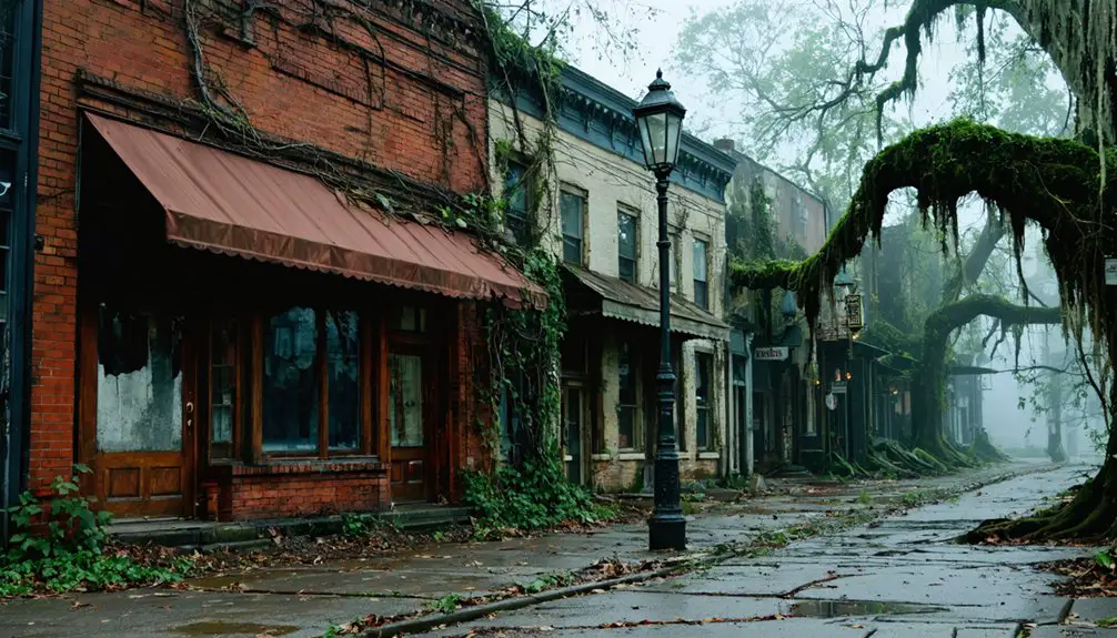
LoneStar: Where Wilderness Claims What Once Was Thriving
When the Pee Dee Land Company laid out Auburn along the Atlantic Coastline and Manchester and Augusta Railroad tracks in the 1890s, speculators envisioned a thriving hub in Calhoun County’s prime cotton-growing region.
Renamed Lone Star after a railroad engineer’s sighting, the settlement promised prosperity through advertised land auctions and train schedules by 1895.
You’ll find nature’s takeover complete now—wilderness consumes the freight depot, general store, and scattered structures that once served local farmers.
The 1929 Sanborn map documented what’s vanished: relocated depots, thriving mercantile businesses, and the brick Masonic hall where citizens gathered.
Though trains still thunder past on active tracks, they don’t stop anymore.
The town’s final decline accelerated post-World War II, eventually leading to the post office closure in 1995.
Ghostly echoes of Mary Zeagler’s 1997 store closure mark the final chapter, leaving crumbling ruins where overgrowth reclaims forgotten streets.
A population sign still stands as a haunting reminder, indicating the town’s dwindled count of just 15 residents before complete abandonment.
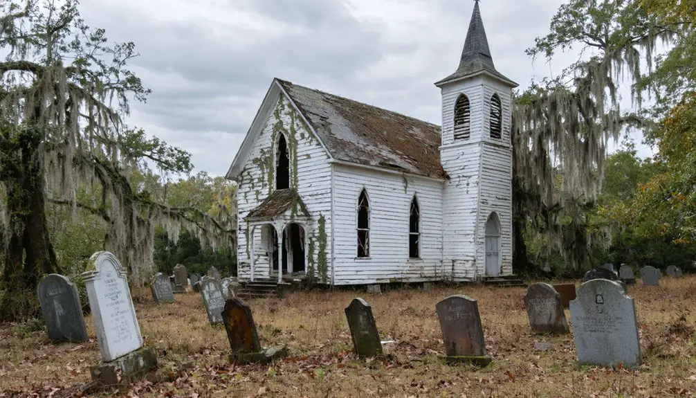
Dorchester: Historical Remnants Fading Into Forest Near Summerville
While Lone Star faded from economic decline, South Carolina’s oldest ghost town met its end through deliberate choice.
You’ll find Dorchester’s archaeological significance preserved beneath 325 acres of reclaimed forest near Summerville, where residents voluntarily walked away around 1775. Founded by Massachusetts Puritans in 1697 as a trading post, it thrived as South Carolina’s third-largest town before Revolutionary War conflicts drove inhabitants elsewhere.
A thriving colonial settlement abandoned by choice in 1775, now preserved beneath centuries of forest regrowth near Summerville.
Today’s historic preservation efforts reveal what wilderness couldn’t erase: St. George’s brick bell tower stands sentinel over excavated remnants yielding thousands of artifacts. The original settlement included 4,050 acres divided into tracts, with 50 acres specifically designated for trade and commerce. Public archaeology excavations in spring and fall allow visitors to participate in uncovering the town’s colonial past.
You’re free to explore trails winding past tabby fortifications and cemetery stones—tangible proof that sometimes abandonment, not destruction, best protects our heritage. Fewer than ten percent of original lots have surrendered their secrets.
Ellenton: The Town That Vanished for Nuclear Development
The Cold War erased Ellenton more thoroughly than any economic collapse ever could.
You’ll find nothing left of Mary Ellen Dunbar’s namesake town, founded in 1870 along the Port Royal Railroad. When the U.S. Atomic Energy Commission selected this Barnwell County site for hydrogen bomb production in November 1950, 6,000 residents faced displacement. The last person departed April 1, 1952, leaving behind seventy years of Ellenton history.
Bonner Smith’s handmade protest sign—crafted with shoe polish and gum wood—captured the tragedy: loving their town while acknowledging Cold War necessity. The Savannah River Site‘s nuclear legacy consumed everything.
Today, New Ellenton stands miles away, incorporated that same April, while nature reclaims the original townsite. New Ellenton’s population swelled to 2,309 by 1960 as workers flooded in during the facility’s construction phase. The original Ellenton now exists only as a disambiguation reference, sharing its name with other locations across different states. You’re witnessing freedom’s price: communities sacrificed for national survival.
Andersonville: Submerged Beneath Lake Hartwell’s Waters
Cold War necessity erased Ellenton from maps, but Lake Hartwell’s waters accomplished something equally permanent—they swallowed Andersonville whole.
You’ll find precious little above water now—just time-worn roads crossing a 400-acre island near Portman Marina, marked by buoys that warn boaters away from what lies beneath.
Andersonville history tells of a thriving river port established in 1801, complete with a 40-room hotel and flourishing Female Academy.
By 1963, the Corps of Engineers’ Hartwell Dam had drowned it all—displacing over 2,000 residents and erasing a once-strategic commerce center.
The lake itself stretches across 56,000 surface acres with 962 miles of shoreline, maintained at an average depth of 45 feet that keeps Andersonville’s remnants perpetually submerged.
Divers report submerged architecture still standing: weathered walls, grave markers, structures untouched beneath the depths.
Some explorers have reported an eerie feeling of being watched while navigating the waters near the town’s original location.
The town’s physical form remains preserved in cold water, beyond bureaucratic interference, a monument to nature’s reclamation power.
Abandoned Golf Courses: Myrtle Beach’s Jungle Transformation
Between 2000 and 2016, Myrtle Beach’s signature industry consumed itself—22 golf courses shuttered across the Grand Strand, abandoning roughly 3,675 acres to nature’s reclamation.
You’ll find these golf course transformations fascinating: manicured fairways evolved into jungle-like ecosystems within years, displaying ecological succession’s raw power.
Bay Tree Golf Plantation, America’s first 54-hole layout, closed in 2006 for housing development that never materialized. Instead, vegetation consumed putting greens while methamphetamine labs and homeless encampments occupied crumbling clubhouses—police discovered one drug operation just weeks before demolition.
The Witch and Wild Wing Plantation followed similar trajectories: sold to developers, then left partially operational or completely abandoned. Waterway Hills Golf Club featured a unique gondola transport from parking lot to clubhouse before its 2015 closure, adding another distinctive venue to the region’s lost recreational infrastructure. The abandoned courses represented 18% of total golf facilities registered with the Myrtle Beach Golf Association, marking a dramatic shift in the region’s recreational landscape.
Today, spray-painted graffiti marks dystopian landscapes where politicians once played, proving nature doesn’t require permission to reclaim what humans discard.
Cotton Gin Ruins: Metal Skeletons in the Midlands
Rusting through Midlands forests, skeletal cotton gins mark where South Carolina’s agricultural empire collapsed across two centuries of economic devastation.
You’ll find these metal skeletons off Cedar Street in Salley, where tin roofs poke through tall trees, and at Goodwill Plantation in Eastover, where 1860s machinery crumbles beneath encroaching vines.
Eli Whitney’s cotton gin innovation transformed short-staple processing in 1793, pushing production past 100,000 bales by 1820.
Whitney’s 1793 gin invention revolutionized short-staple cotton processing, catapulting South Carolina’s production beyond 100,000 bales within three decades.
But Civil War blockades, emancipation, and the 1918 boll weevil infestation idled these operations permanently.
The Chappells Gin burned in 2005, exposing charred frameworks now consumed by regional flora.
These ruins testify to cotton’s historical significance—and nature’s patient reclamation of industrial monuments.
What powered empires now feeds forest undergrowth.
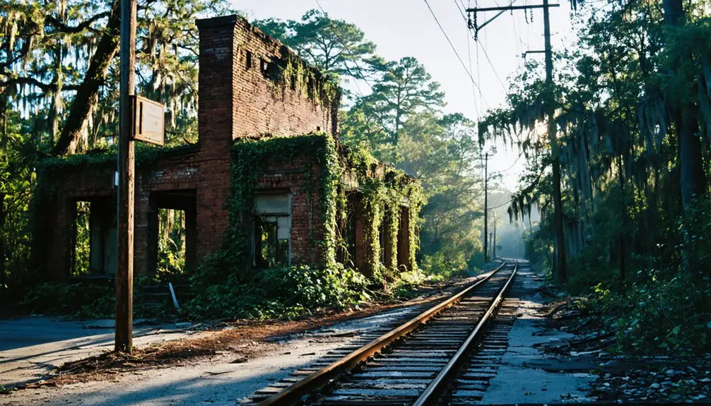
Forgotten Train Trestles: Crumbling Bridges Over Time
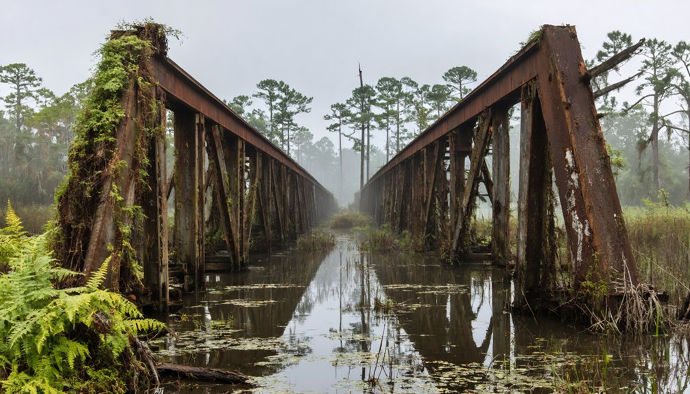
You’ll find South Carolina’s abandoned railroad trestles marking where human ambition once conquered rivers and valleys, from the Catawba River’s granite pillars that outlasted their wooden spans since 1852 to the twisted rails embedded in streambeds above Reedy Cove Falls.
These engineering remnants now serve as wildlife corridors, with deer crossing stone foundations and birds nesting in deteriorating timber where locomotives once thundered daily.
The 1980s peak abandonment period left behind structural skeletons that reveal how quickly nature reclaims industrial infrastructure—wooden pilings rot into riverbeds while granite endures earthquakes, floods, and 170 years of seasonal erosion.
Structural Decay and Erosion
When South Carolina’s railroad builders drove cypress pilings into swampy ground in the 1830s, they couldn’t have predicted their wooden structures would outlast the very tracks they supported.
You’ll find remnants of the Charleston-Hamburg line exposed by erosion after 150 years, their structural integrity surprisingly intact despite nature’s relentless advance.
The environmental impact tells a different story. Abandoned railroad cuts transformed into stormwater channels, carving towering canyons that toppled trees and smothered vegetation with sediment.
In Hitchcock Woods, flooding dislodged concrete slabs from retaining walls, while erosion washed original track sections into Sand River. The Horse Show Grounds relocated twice as siltation claimed the land.
Even longleaf pine pilings, rotting within two years of construction, outlasted the railroad’s operational life—their skeletal remains surfacing whenever earth shifts.
Wildlife Corridors Through Ruins
Across South Carolina’s abandoned rail corridors, nature hasn’t simply reclaimed the infrastructure—it’s transformed crumbling trestles into essential arterial pathways for wildlife movement.
You’ll find turtles sunning on exposed stonework where Sherman’s forces once destroyed strategic crossings near Peak, while anole lizards shift from green to brown along embankments choked with Christmas fern and wild ginger.
These wildlife corridors demonstrate rapid ecological restoration—forty-year-old hardwood stands now tower over fifty feet where locomotives once thundered.
The overgrown ruins create protected passages through otherwise fragmented landscapes, connecting farmland to forest.
Where crustose lichens colonize quartz outcroppings and early successional plants mark abandonment timelines, you’re witnessing freedom’s truest form: ecosystems operating without human constraint, reclaiming what was temporarily borrowed.
Commercial Relics: Coca-Cola Caps and Faded Storefronts
Though Coca-Cola signs have long since faded from their tin facades, South Carolina’s abandoned storefronts preserve the commercial rhythms that once animated these rural crossroads.
You’ll find commercial nostalgia embedded in Pomaria’s bank ruins, where floods from the Broad River erased a settlement that thrived since 1823.
At Mountville, brick buildings that once served railroad commerce now host grange meetings, their Sanborn-mapped stores converted to warehouses.
The Jenkins Store on Dave Jenkins Road stands beside its owner’s residence—a family watching their commercial legacy decay.
Ware Shoals presents the starkest urban decay: an entire business district abandoned, its replacement depot relocated to private land.
Even Crenshaw’s convenience store, adorned with cattle skulls, reflects this pattern of rural commerce yielding to nature’s persistent advance.
Wildlife Reclamation: From Human Habitation to Animal Sanctuary

When you examine South Carolina’s ghost towns decades after abandonment, you’ll find forests threading through collapsed roofs and wildlife occupying rooms where families once gathered.
The archaeological record shows this shift: plantation rice fields now shelter alligators and waterfowl, while submerged towns beneath Lake Marion function as aquatic habitats where tenant farmers’ homes once stood.
This pattern repeats across the Lowcountry—each human displacement creating space for ecological succession that transforms communities into functioning wildlife sanctuaries.
Flora Overtakes Abandoned Structures
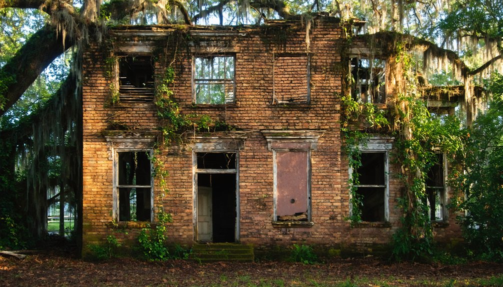
South Carolina’s abandoned settlements surrender to vegetation within decades of their final inhabitants’ departure.
You’ll find climbing vines weaving through crumbling mortar while ferns establish themselves in moisture-rich interiors of vacant structures. Abandoned architecture becomes unrecognizable as cypress groves colonize flooded mill towns and trees sprout directly through collapsed metal roofs. Nature’s resilience transforms human-built environments into self-sustaining ecosystems within approximately fifty years.
Root systems compromise remaining foundations while high humidity creates perfect microclimates for aggressive plant growth.
Remote swampland locations accelerate this process—what you once recognized as streets and buildings now disappears beneath viridescent overgrowth. Former settlements submerged by lake impoundment develop entirely new underwater vegetation systems.
Complete forest succession eventually obscures all evidence of human occupation, reclaiming what civilization temporarily borrowed.
Fauna Inhabits Former Towns
As vegetation reclaims architecture, animal populations establish dominion over South Carolina’s abandoned human settlements.
You’ll witness urban wildlife transforming colonial sites into ecosystems where predators patrol former streets and wetland species reclaim plantations.
Historical ecology reveals nature’s territorial expansion through:
- Predator Resurgence: Pumas and black bears now occupy Charles Towne Landing’s 22-acre habitats, traversing paved trails where settlers once walked, while otters navigate waterways mimicking 1670 landscapes.
- Wetland Dominance: Alligators command Donnelley’s 8,000 acres of former rice fields, with waterfowl populations thriving across conservation zones where human agriculture failed.
- Avian Proliferation: Red-cockaded woodpeckers inhabit 5,866-acre pine stands, while herons, eagles, and seaside sparrows colonize ghost forest marshes.
Deer, turkeys, and marine birds complete this reclamation, establishing autonomous territories across abandoned settlement zones.
Ecosystems Replace Human Activity
Where colonial settlements and plantation economies once dominated South Carolina’s coastal plain, systematic ecosystem transformation now erases centuries of human occupation.
You’ll witness dying forests converting to wetlands through prolonged saltwater flooding, while salt-tolerant marsh grasses colonize former pine stands. This ecosystem resilience demonstrates nature reclamation at unprecedented scales—6 million dead trees mapped across coastal zones signal shifts from forests to open water.
Protected watersheds spanning thousands of acres now support flourishing native vegetation where human activity once prevailed. Oyster reefs trap sediment and reduce erosion along former inhabited shorelines, while prescribed burns regenerate fire-adapted plants suppressed for decades.
The landscape you observe today reflects three decades of accelerated environmental changes, converting human-dominated spaces into self-sustaining wetlands, marshes, and restored longleaf ecosystems that operate independent of human intervention.
Photography Hotspots: Capturing Decay and Natural Rebirth
Through decades of abandonment, South Carolina’s forgotten structures have become living galleries where photographers document the eternal struggle between human construction and natural reclamation.
In South Carolina’s ruins, nature’s patient reclamation transforms abandoned architecture into haunting monuments of civilization’s impermanence.
You’ll find exceptional subjects where vine-strangled walls and forest-consumed foundations reveal time’s patient work.
Prime locations for urban exploration include:
- Adams Grove Presbyterian Church – Its 1853 woodwork frames intimate shots of structural collapse against cemetery overgrowth.
- Fort Fremont’s bunkers – Concrete fortifications crumbling into St. Helena Island’s encroaching forest create dramatic long-exposure opportunities.
- Lando School’s ornate facade – Intricate architecture intertwined with trees offers layered compositions.
Your photographic techniques should emphasize wide-angle lenses capturing nature’s advance through broken windows and collapsed roofs.
These sites preserve archival evidence of civilization’s temporary footprint, offering freedom to document humanity’s inevitable return to wilderness.
Frequently Asked Questions
Is It Legal to Visit and Explore These Abandoned Ghost Towns?
You’ll need landowner permission before exploring, as ghost town regulations treat these sites as private property where trespassing applies. However, areas with historical significance may offer legal access through documented public pathways or designated heritage programs respecting human-nature interaction.
What Safety Precautions Should Visitors Take When Exploring These Sites?
You’ll need proper safety gear including sturdy boots and gloves, plus wildlife awareness since nature’s reclaiming these spaces. Document structural decay, watch for snakes and unstable floors, and respect the land’s transformation back to wilderness.
Are Guided Tours Available for Any of These Ghost Towns?
You’ll find guided exploration at Lost Cove through Southern Appalachian Highlands Conservatory’s hiking trips, while sites like Rose Hill Plantation and Fort Fremont offer preserved access showcasing their historical significance through human-nature interaction across decades of abandonment.
What Caused Most South Carolina Towns to Become Abandoned?
You’ll find most abandonments stem from economic decline and industrial shift—flooding for hydroelectric dams, nuclear facilities forcing relocations, railroad collapse, and timber exhaustion. These forces displaced thousands, leaving communities unable to sustain themselves independently.
Can Artifacts or Relics Be Collected From These Abandoned Sites?
No, you can’t collect artifacts legally. Despite what treasure-hunting fantasies suggest, artifact preservation laws and relic ethics protect these sites. You’ll face fines up to $10,000—freedom doesn’t include pillaging history for personal gain.
References
- https://www.onlyinyourstate.com/experiences/south-carolina/abandoned-places-in-sc
- https://www.lemon8-app.com/@urbexgeorgiajenn/7447529305376178734?region=us
- https://www.earthisland.org/journal/index.php/magazine/entry/fairway_to_heaven/
- https://www.randomconnections.com/ghost-towns-of-south-carolina/
- https://www.youtube.com/watch?v=FY9L9EeJjCs
- https://www.youtube.com/watch?v=KQOA3Q1z0Nc
- https://www.atlasobscura.com/places/dorchester-south-carolina-s-abandoned-town
- https://en.wikipedia.org/wiki/List_of_ghost_towns_in_South_Carolina
- https://www.randomconnections.com/lone-star-barbecue-mercantile-and-ghost-town/
- https://www.youtube.com/watch?v=ODUzsxh5JXs