You’ll find Iowa’s most atmospheric ghost towns nestled among autumn-blazed landscapes, where stone ruins and weathered structures create haunting tableaux. Rockville’s 19th-century mills crumble along the Upper Iowa River, while Elkport’s foundations scatter beneath Mississippi bluffs ablaze with golden foliage. Buckhorn’s graffiti-covered creamery and Carrollton’s sprawling collection of abandoned buildings offer unparalleled photographic opportunities. Further south, Mount Etna’s prairie ruins and Sunbury’s lonely church steeple stand as silent monuments to vanished communities, their stories waiting just beyond the fallen leaves.
Key Takeaways
- Elkport in Clayton County features dramatic bluffs, golden autumn fields, and scattered stone foundations reclaimed by farmland after 2004 flooding.
- Buckhorn near Maquoketa offers weathered wooden structures, including a historic creamery and whitewashed church, surrounded by fall foliage and scenic vistas.
- Carrollton in Carroll County contains Iowa’s largest collection of abandoned buildings with peeling paint and rusted roofs, ideal for atmospheric autumn photography.
- Rockville showcases 19th-century stone ruins along the Upper Iowa River, with moss-covered structures framed by vibrant fall colors and historical depth.
- Mount Etna in Adams County presents weathered single-story buildings and historic cemeteries amid quiet tallgrass prairie landscapes perfect for fall exploration.
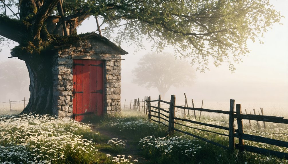
Rockville: Stone Structures Along the River
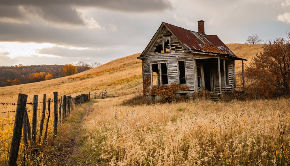
Tucked away in Iowa’s rolling landscape, Rockville stands as a haunting reminder of 19th-century ambition that couldn’t outlast economic shifts and changing transportation routes. You’ll discover ancient stonework scattered along the water’s edge, where settlers once built their dreams into permanent foundations.
The riverbank ruins tell stories of mills, bridges, and homes that thrived when waterways meant commerce and community.
As you explore these crumbling structures during fall’s golden hours, you’re free to wander among walls that nature’s gradually reclaiming. Moss-covered stones and weathered mortar create an atmospheric backdrop against autumn foliage.
The river still flows past these forgotten monuments, indifferent to human ambitions. Just upstream, the Coralville spillway experienced its first overtopping in 1993, when heavy rains brought floodwaters that would dramatically reshape the landscape and expose fossils hidden for millions of years. Iowa’s river valleys have drawn human settlement for centuries, with the Upper Iowa River in Allamakee County supporting prehistoric communities through abundant fish, mussels, and rich floodplain soil ideal for agriculture. It’s a place where you can disconnect from modern constraints and contemplate what permanence really means.
Elkport: Mississippi River Bluffs and 19th-Century Decay
Along the convergence of Turkey River and Elk Creek in Clayton County, Elkport presents one of Iowa’s most sobering ghost town narratives—a community that didn’t fade gradually but vanished almost overnight.
The catastrophic 2004 flood submerged this 150-year-old settlement under ten feet of water, prompting all 88 residents to accept federal buyouts. By 2006, bulldozers had erased nearly everything.
Today, you’ll find scattered foundations amid reclaimed farmland—poignant reminders where historical preservation couldn’t compete with nature’s fury. Before disaster struck, Elkport’s median household income stood at $24,375, reflecting a modest community where families had built their lives for generations.
The riverfront scenery remains stunning, with dramatic bluffs framing the Turkey River’s peaceful flow. Established in 1855, the town had flourished for nearly a century and a half before nature reclaimed it. Fall transforms this haunting landscape into something transcendent: golden fields, scattered stone remnants, and woodlands ablaze with color.
You can fish, canoe, or simply wander these quiet spaces, contemplating how quickly established communities can disappear.
Buckhorn: Artist Enclave With Weathered Wooden Buildings
You’ll find Buckhorn’s weathered creamery and whitewashed church rising from the farmland just west of Maquoketa, where graffiti-covered walls now serve as canvas for passing artists.
The thirty-minute drive from Dubuque along Highway 61 rewards you with a glimpse into Iowa’s agricultural past, where a cooperative once churned 34 million pounds of butter before abandonment claimed its buildings.
Circle the crumbling structures on foot this autumn, when fallen leaves scatter among the bricks and Civil War-era headstones, though respect property boundaries—interiors remain off-limits despite their haunting appeal. The creamery’s butter distribution routes once stretched throughout the Midwest, connecting this rural community to major markets across the region. The town’s name traces back to antlers mounted at Shadrach Burleson’s tavern, established when he first settled this land in 1836.
Creative Community Among Ruins
Weathered planks and peeling paint tell stories of transformation at Buckhorn, where a once-thriving creamery now inspires artistic imagination rather than dairy commerce. You’ll discover how historical preservation takes unexpected forms here—graffiti-covered walls inside crumbling structures blend with exterior whitewash, creating an accidental gallery among the ruins.
The creamery’s name honors grandparents who hauled milk cans to this very location, connecting past agricultural heritage with modern creative vision.
Community revival emerges through artistic reinterpretation rather than traditional restoration. You’re free to explore exteriors, though interiors remain off-limits due to dangerous collapsed sections and scattered debris.
The haunting atmosphere, enhanced by scenic Jackson County views off Highway 64, draws those seeking inspiration from decay—where weathered chairs and brick fragments become meditation points for creative souls. An old cemetery stands opposite the former creamery, adding to the settlement’s ghostly character. Located just west of Maquoketa, this small ghost town sits approximately 30 minutes from Dubuque via Highway 61, making it an accessible autumn excursion for photographers and history enthusiasts alike.
Autumn Drive to Buckhorn
From Dubuque, the thirty-minute journey south along Highway 61 delivers you to Maquoketa’s exit, where Highway 64 carries you westward into Jackson County’s rolling farmland. The route winds through territory where wildlife habitat reclaims abandoned homesteads, and autumn transforms the landscape into blazing corridors of amber and crimson. You’ll find Buckhorn in the middle of nowhere—precisely where it belongs.
Cedar Rapids travelers commit one hour to this pilgrimage; those from Waterloo invest ninety minutes.
The cooler October air sharpens your focus on what remains: weathered wooden buildings that defy historical preservation efforts, a creamery with its partially collapsed roof, and a church standing resolute against time. Founded around 1899 when 20 farmers formed a cooperative, Buckhorn became the heart of a dairy community that would serve hundreds of patrons across the region.
The scenic isolation amplifies fall’s appeal—perfect conditions for bonfires among structures that witnessed 34 million pounds of butter production before silence settled over everything. The area’s connection stability during your visit depends on cellular coverage, as this remote location tests modern technology against historical preservation.
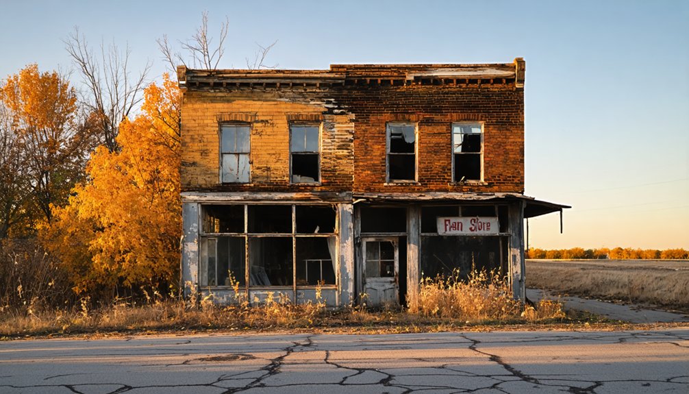
Carrollton: Iowa’s Largest Collection of Abandoned Structures
You’ll find Iowa’s most extensive ghost town in Greene County, where Carrollton sprawls across the prairie with dozens of collapsed houses, barns, and stripped farm buildings. The town withered after railroads bypassed it in favor of nearby Carroll, leaving behind a haunting landscape of peeling paint, caved-in roofs, and exposed timber skeletons.
Fall transforms this decay into a photographer’s paradise, as golden light filters through broken windows and autumn foliage frames the crumbling structures.
Dozens of Deserted Buildings
Scattered across Carroll County’s prairie landscape, Carrollton holds the distinction of harboring Iowa’s largest collection of abandoned structures—a haunting assemblage of dozens of deserted buildings that tell the story of frontier ambition gone silent.
You’ll discover wooden shanties hastily erected during the town’s founding, their weathered frames standing as testament to the settlers’ quick but ultimately fragile construction methods. The simple business buildings mirror these residential structures, with exposed boards revealing why historical preservation efforts face such challenges with abandoned architecture from this era.
Walking through Carrollton, you’ll encounter the 1868 schoolhouse, the railroad station that served as the town’s second building, and countless other structures now open to vandalism and decay.
Each deteriorating frame speaks to economic hardship—a community where settlers reportedly arrived without a single dollar.
Railroad Bypass Caused Decline
When the Burlington Northern Railroad completed its mainline bypass at Cotter in October 1953, Carrollton’s fate was effectively sealed.
The new route redirected all mainline traffic southwest through Tater Hills, transforming the original 1884 line into a mere trunk operation. You’re witnessing railroad history’s brutal efficiency—commerce and passengers simply vanished overnight as trains no longer stopped here.
The transportation decline accelerated dramatically. What once hosted two Doodlebugs running to Burlington, Iowa in the 1930s dwindled to mixed-use service by 1945. By 1981, rails were torn from the ground entirely.
Combined with losing the county seat in 1869, this bypass delivered Carrollton’s final blow. The town couldn’t survive without its transportation lifeline—a cautionary tale of progress leaving communities behind.
Peak Fall Photography Opportunities
As autumn transforms Iowa’s landscape, Carrollton emerges as the state’s premier destination for abandoned structure photography. You’ll find golden hour light illuminating tongue-and-groove trim and basement brickwork, while fall foliage creates dramatic contrasts against weathered structures. Mid-October delivers peak leaf change, enhancing rusted metal roofs and exposed beams with vibrant color pops.
Pack your urban exploration gear for misty morning shoots when fog adds atmospheric depth to roadside farmsteads. You’ll discover exposed skylights framing autumn skies through decay, peeling paint layered with leaf litter, and vintage artifacts like Dr Pepper coolers awaiting your lens.
The caved-in upper floors reveal beam networks against brilliant backdrops, while overgrown weeds frame leaning barns perfectly. Though historical ghost stories rarely mention Carrollton, these silent structures tell their own haunting tales through your viewfinder.
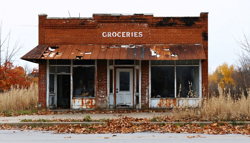
Sunbury: Flood-Abandoned Village With Church Steeple Landmark
The quiet fields of Cedar County, roughly 30 miles west of Davenport, conceal the faded remnants of Sunbury, a railroad-era settlement that never quite recovered from the twin blows of the Great Depression and persistent flooding.
You’ll find little standing now—the brick bank that closed in the 1930s was finally razed around 2014, and the legendary dance hall that drew crowds until 1964 has vanished completely. What remains are scattered foundations and community memories of a town that once thrived with 50 residents and fertile farmland.
The church steeple, documented in flood control records, serves as your visual marker across these open landscapes. Victorian architecture has surrendered to time, leaving you to trace Sunbury’s outline through absence rather than presence.
Mount Etna: Remote Prairie Ruins in Southern Iowa
Deep in Adams County’s windswept tallgrass prairie, Mount Etna crumbles into the earth that birthed it in 1839. You’ll find weathered single-story buildings with broken windows standing sentinel over what once thrived as a seventy-four-lot settlement.
The Salamonie River’s damming sealed this town’s fate—post office gone, churches shuttered, the one-room schoolhouse closed since 1960.
Wander among the ruins near Lake Icaria, where legendary ghost stories whisper through abandoned structures. The active Odd Fellows Cemetery—relocated during dam construction—contrasts sharply with dormant Sprowl Cemetery’s fifty-nine forgotten stones.
Historic preservation efforts remain minimal here; nature reclaims what roads and progress abandoned.
You’re free to explore this remote prairie ghost town where Iowa’s frontier past dissolves into tallgrass and silence.
Frequently Asked Questions
Are Iowa Ghost Towns on Private Property or Public Land?
You’ll find Iowa’s ghost towns mostly sit on private ownership land, not public property. While historic preservation efforts vary, you’re typically exploring private land requiring permission. Always respect property rights and seek landowner consent before venturing onto these atmospheric sites.
What Safety Precautions Should Visitors Take When Exploring Abandoned Structures?
You’ll need safety gear like sturdy boots, flashlights, and masks before entering. Test floors carefully, never explore alone, and respect historical preservation by leaving everything untouched. Always secure permission first—trespassing charges aren’t worth the adventure.
Do Any Ghost Towns Require Permits or Permissions to Visit?
You won’t need permits for Iowa’s ghost towns—most cemeteries and church exteriors welcome free exploration. However, respect private property boundaries at places like Buckhorn. Historical preservation efforts mean you’ll find great photography tips capturing these weathered, accessible ruins.
What Is the Best Time in Fall to Visit Iowa Ghost Towns?
Mid-September through mid-October offers you prime ghost town exploration when vibrant foliage frames crumbling structures for exceptional photography opportunities. Historical preservation efforts remain visible before winter, while comfortable temperatures let you wander freely among Iowa’s forgotten settlements.
As you embark on scenic drives in Iowa’s ghost towns, you’ll discover hidden gems waiting to be explored. Each turn reveals remnants of the past, with hauntingly beautiful landscapes that beckon photographers and history enthusiasts alike. The tranquil roads not only provide a glimpse into the state’s rich history but also invite reflection and appreciation of its evolving story.
Are There Guided Tours Available for Iowa’s Ghost Towns?
Like scattered pages from history’s forgotten book, Iowa’s ghost towns lack formal guided exploration. You’ll need to venture independently, as historical preservation efforts haven’t established traditional tours. However, nearby haunted sites offer professionally-led paranormal walks that capture similar atmospheric mystery and frontier spirit.
If you’re up for a unique adventure, explore ghost towns in Hannibal and beyond, where the remnants of the past beckon with untold stories and eerie allure. As you wander through these desolate landscapes, you may encounter abandoned structures that whisper the tales of lives once lived, adding an intriguing layer to your journey. Be sure to capture the haunting beauty of these locations, as they serve as a testament to a bygone era waiting to be rediscovered.
References
- https://www.traveliowa.com/10-must-visit-fall-attractions/
- https://www.circleofash.com
- https://www.adventurelandresort.com/discover-adventureland-resort/Phantom-Fall-Fest
- https://www.iowahauntedhouses.com
- https://www.thegazette.com/travel/a-day-away-plan-a-haunted-iowa-road-trip-to-these-spirited-sites/
- https://www.onlyinyourstate.com/experiences/iowa/ia-ghost-town
- https://clearlakeiowa.com/fall-fun-in-clear-lake-iowa/
- https://www.survivingateacherssalary.com/off-the-beaten-path-the-lost-towns-under-lake-red-rock-iowa/
- https://www.mvr.usace.army.mil/coralvillelake/recreation/devonian-fossil-gorge/gorge-history/
- https://en.wikipedia.org/wiki/Upper_Iowa_River_Oneota_site_complex