You’ll find Massachusetts’ most haunting ghost towns emerging from fall foliage like forgotten memories. Explore Dogtown’s 3,600 wilderness acres where cellar holes hide beneath brilliant autumn leaves, or visit Dana’s preserved ruins above Quabbin Reservoir, where 7,500 graves were relocated before flooding. When Enfield’s waters recede in October, submerged foundations resurface along 25 miles of shoreline. Time your visit during peak foliage—late September through mid-October—when vibrant colors transform abandoned homesteads into photographer’s dreams, and weekday mornings reveal secrets that patient explorers discover.
Key Takeaways
- Dogtown in Gloucester features 3,600 acres of cellar holes, moss-covered boulders, and haunted legends amid excellent fall foliage.
- Dana’s unsubmerged ruins near Quabbin include accessible stone walls, granite steps, and cellar holes on 68 historic acres.
- Enfield’s submerged remains re-emerge when Quabbin Reservoir waters recede in fall, revealing foundations and historic relics.
- Peak foliage from late September to mid-October creates vibrant backdrops for exploring abandoned structures and photographing ruins.
- Quabbin trails pass former town sites where low water levels expose foundations, roads, and remnants of 1930s displacement.
Dogtown: A Haunted Wilderness in Gloucester
When you venture into the dense woodland paths of Dogtown, you’ll find yourself walking through what feels like Massachusetts’ most melancholic secret—a 3,600-acre wilderness where cellar holes yawn beneath tangles of briars and moss-covered glacial boulders loom like silent witnesses to vanished lives.
This abandoned settlement, once home to sixty prominent families, earned its name from dogs kept by Revolutionary War widows who refused to leave. Haunted legends cling to these woods like morning fog, whispering tales of the freedman Cornelius “Black Neil” Finson, the last holdout dragged to a poorhouse in 1830. Among the area’s most captivating legends are those of Judith Rhines and Tammy Younger, whose reputations as witches of Dogtown have inspired poems and novels celebrating their mysterious stories.
Today, you’ll discover Roger Babson’s inscribed boulders marking abandoned structures—each numbered foundation a portal to Cape Ann’s forgotten past, waiting for those bold enough to explore. The rugged terrain includes treacherous features like Granny Days Swamp near Dogtown Square, where livestock once risked getting stuck in the bog.
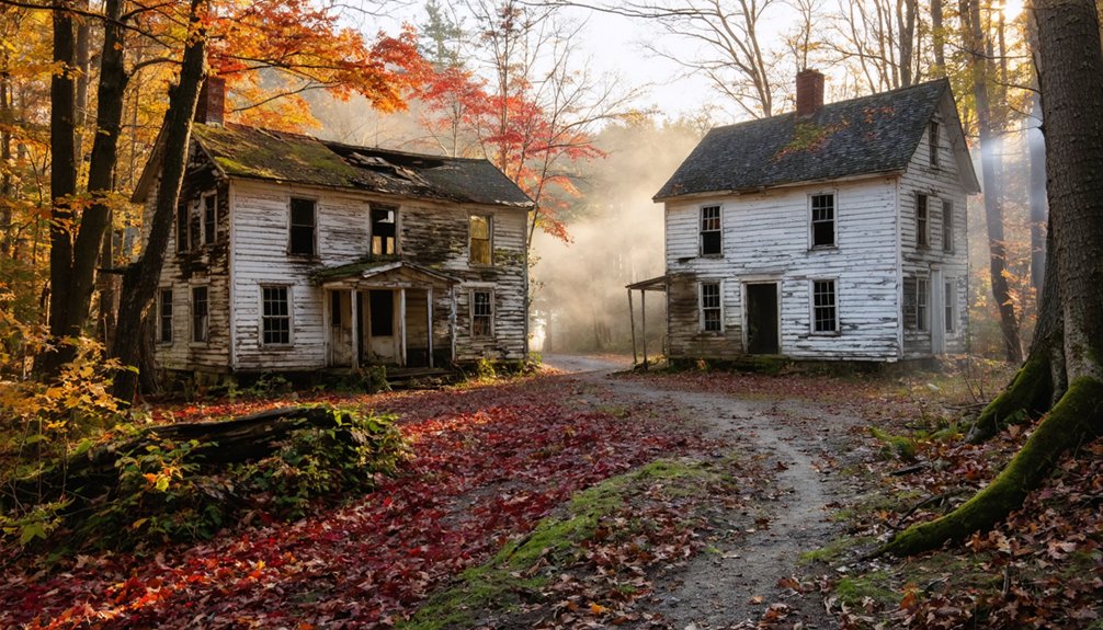
Catamount: Remote Village Turned State Forest
Deep in the hills of southwestern Colrain, where stone walls snake through second-growth forest and cellar holes hide beneath layers of fallen leaves, you’ll discover Catamount—a ghost town so thoroughly reclaimed by wilderness that even its 27-acre lake feels like nature’s secret.
This remote history began with Revolutionary War veterans farming Catamount Hill in the mid-1700s. By 1966, forest preservation transformed 1,125 abandoned acres into state forest.
You’ll hike miles of overgrown roads past foundations where families once gathered, their homes vanished for a century. The Catamount schoolhouse made history in May 1812 by flying one of America’s earliest public school flags. Access requires effort—Catamount Hill Road welcomes only boots, bikes, and snowmobiles after vehicular closure ended erosion from off-roaders.
Cast a line in trout-stocked streams, then wander trails where thousands once attended mountain festivals. Large portions of the exploration area lie within Massachusetts State Forest, though not all land is public. No rangers, no maps—just you and the ghosts.
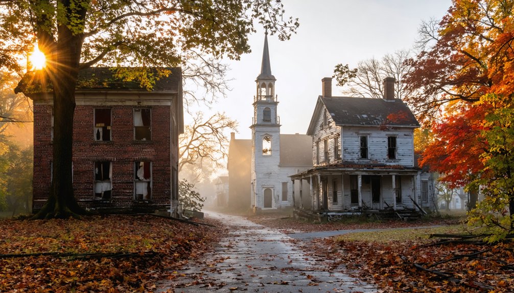
Dana: Unsubmerged Ruins of a Reservoir Town
You’ll find Dana’s ghost more tangible than most—stone walls emerge from moss, granite steps lead to vanished doorways, and a weathered marker stands sentinel over the common where townspeople gathered until 1938.
Unlike its drowned neighbors, this town escaped submersion when the Quabbin Reservoir filled, leaving its skeleton intact above the waterline. The town center once bristled with prosperity—a Civil War cannon, post office, schoolhouse, church, and hotel clustered around the common that anchored three distinct villages.
Trek the 1.5-mile path through October’s blaze of color, and you’ll walk streets where 876 souls once lived, their cellar holes now cradling fallen leaves instead of family hearths. The town shares its name with the Dana family, a prominent Boston Brahmin lineage whose legacy extends across New England’s historical landscape.
Visible Foundations and Memorials
Unlike the submerged streets of Enfield that lie beneath dark reservoir waters, Dana’s higher elevation spared many of its foundations from the flood. You’ll discover granite steps leading nowhere, cellar holes where families once gathered, and stone fence posts marking homesteads that vanished by 1940. These remnants aren’t protected by historic preservation laws—nature’s the only curator here.
Walk the overgrown trails and you’ll find sturdy stone walls built from stream-sourced rock, standing defiant against decades of weathering. The old town common features memorials that honor the settlement founded in 1676. Urban legends whisper through the ruins, though the real story’s haunting enough: 7,500 bodies exhumed, memorials relocated to Quabbin Park Cemetery in Ware, an entire community erased for Boston’s thirst.
The foundations remain accessible—tangible proof that freedom sometimes demands sacrifice. The reservoir’s completion in 1946 marked the end of these towns, creating what was then the world’s largest man-made reservoir.
Cemetery Field and Common
At Dana Common, five forgotten roads converge on a triangular ghost where nothing stands but memory. You’ll find a 1996 stone marker commemorating what thrived here from 1801 to 1938—stores, taverns, a meetinghouse that doubled as town hall.
The archaeology speaks through absence: where cannons once honored war dead, only autumn leaves gather now.
Beyond the common, stone posts outline Cemetery Field’s borders. Seven hundred souls rested here before the state emptied every grave for Quabbin Reservoir. Their remains relocated, the land returned to wilderness.
This 68-acre National Register site represents Massachusetts’s best-preserved archaeological landscape of municipal erasure. Dana’s population peaked at 876 during the mid-19th century before decline set in after railroad development. The town was officially incorporated in 1801 after settlement began in 1763.
Historical preservation here means maintaining emptiness—the woods, walls, and fields that reclaimed what progress demanded sacrificed.
Hiking Old Dana Road
The pre-1930s asphalt under your boots tells stories through cracks and frost heaves as you follow Old Dana Road from Gate 40 into Massachusetts’s most walkable ghost town.
Stone walls emerge from brilliant foliage, guiding you past cellar holes where families once gathered for supper. The autumn ambiance intensifies around the bend toward Gate 43—rusty hinges, cobblestone foundations, an old orchard reclaiming itself.
Mystery tales swirl around these ruins, particularly near where Asa “Popcorn” Snow’s relocated tomb once stood. You’re free to wander respectfully along concrete walkways leading to the former town hall‘s foundation, where placards show faces of displaced residents.
Each foundation reveals another sacrifice Boston’s thirst demanded, another home dismantled for reservoir construction.
Enfield: Submerged Secrets of Quabbin Reservoir
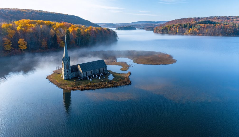
When autumn winds lower Quabbin’s waters, you’re witnessing a graveyard’s slow resurrection—cellar holes, stone foundations, and lonely road beds emerging from depths that swallowed Enfield whole in 1938.
The reservoir’s 25-mile shoreline threading through 120,000 acres becomes a time machine each fall, where hiking trails lead you past ghostly remnants of a town that sacrificed itself for Boston’s thirst.
Standing at Enfield Lookout, you’ll peer across 412 billion gallons concealing churches, homes, and the memories of 2,000 displaced souls whose final farewell ball ended at midnight before the waters came.
Drowned Town History
Beneath Quabbin Reservoir’s placid surface lies Enfield, the wealthiest and most populous of four Massachusetts towns erased to quench Boston’s thirst.
You’re standing above a drowned world where 2,000 souls once thrived among fourteen mills humming with industry.
In 1938, after the State Legislature condemned the Swift River Valley, everything burned—months of fires consuming homes, factories, and dreams before the valley flooded.
They even exhumed 7,600 bodies, leaving nothing but scorched earth.
Today’s haunted legends whisper of that final farewell ball on April 27th, when townspeople danced one last time before midnight struck their legal death.
Urban legends claim you can still glimpse church steeples during droughts.
From Enfield Lookout, you’ll peer into forty square miles of calculated erasure—freedom sacrificed for progress.
Low Water Reveals Ruins
During extreme droughts, Quabbin’s water level drops low enough to expose Enfield’s submerged secrets—foundations that haven’t felt sunlight in eight decades suddenly break the surface like skeletal fingers.
You’ll witness granite steps leading nowhere, stone fenceposts marking phantom property lines, and cellar holes gaping like open wounds in the earth. Water level fluctuations reveal what Massachusetts tried to erase: remnants of roads where families once traveled, foundations where children played, the bones of a town sacrificed for Boston’s thirst.
The reservoir ecology shifts dramatically during these drawdowns—receding waters expose a moonscape the state deliberately created by stripping every tree, burning all vegetation, and razing 650 buildings before the 1939 flooding began.
Reservoir Hiking Trails
The reservoir’s perimeter offers over 100 miles of trails where you’ll walk roads that once carried schoolchildren and merchants. Your boots will crunch over gravel that paved Enfield’s Main Street.
Gate 11 leads you downhill past stone foundations and cellar holes before reaching cobbled beaches.
Dana Common’s northern route climbs Skinner Hill—steep sections rewarded with water views that’ll catch your breath.
The Enfield Lookout loop presents haunting photos of the submerged town beside farmers’ stone walls.
For quick escapes, Gate 52’s rugged path drops you shoreside in minutes.
Hank’s Meadow’s flat half-mile suits families perfectly.
Goodnough Dike’s paved road provides wheelchair-accessible views.
Trail maintenance keeps paths clear for wildlife encounters—deer, eagles, and occasional moose sharing these quiet memorial grounds.
Salem: The Witch City’s Ghostly Legacy
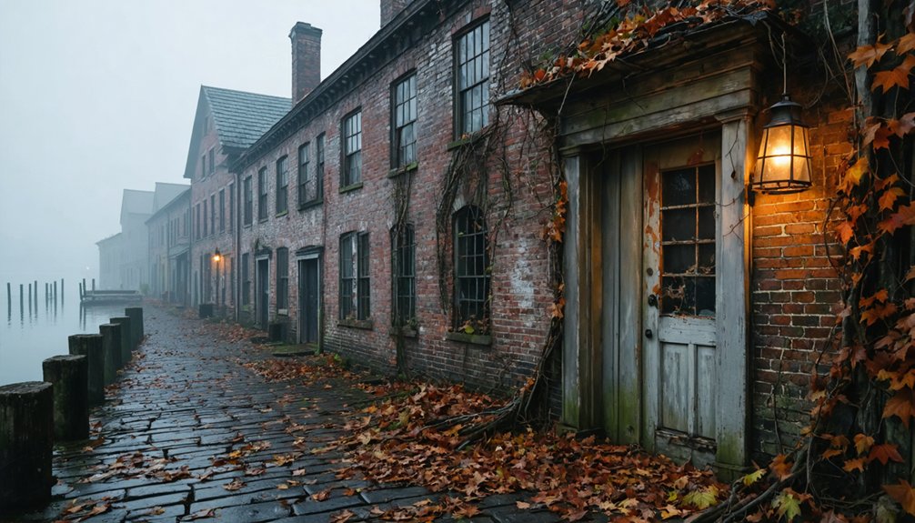
When autumn leaves begin to fall across Massachusetts, Salem transforms into something far darker than its typical seaside charm suggests. You’ll walk cobblestone streets where over 200 souls faced witchcraft accusations between 1692 and 1693—a hysteria fueled by spectral evidence that condemned nineteen to the gallows.
The air grows heavy near Proctor’s Ledge, where bodies swung from nooses, and at the old jail site where five perished awaiting trial. You can almost hear four-year-old Dorcas Good’s cries echoing through centuries. Giles Corey’s defiant silence still haunts Howard Street, where stones crushed him for refusing to plead.
October brings costumed tourists, but step away from the crowds at dusk—Salem’s genuine ghosts don’t perform on schedule.
Old Sturbridge Village: Historic Phantoms and Fall Festivities
Beyond Salem’s gallows and grief lies a different kind of haunting—one where the past performs its daily rituals across 200 acres of reconstructed history. You’ll wander Old Sturbridge Village’s 40+ antique buildings while costumed interpreters spin wool and forge iron as their ancestors did in the 1830s.
Come October, the village transforms for Phantoms by Firelight. You’ll encounter ghostly legends flickering through fields and historic homes, bonfires crackling against the autumn atmosphere. Children clutch trick-or-treat bags while dramatic displays unfold near the pond—magic seeping through weathered clapboards and stone foundations.
This isn’t manufactured fear. It’s something deeper: 40,000 artifacts whispering their stories, roosters wandering past the Thompson Bank’s counterfeit detector, history refusing to stay silent. The dead here don’t rest—they demonstrate.
Best Times to Visit Massachusetts Ghost Towns in Autumn
Timing your ghost town pilgrimage means dancing between nature’s calendar and human crowds. Late September through mid-October delivers peak foliage—crimson maples frame abandoned buildings perfectly for seasonal photography.
The second to third week of October transforms the Berkshires into a painter’s canvas, though you’ll share Salem’s haunted folklore with nearly a million other seekers.
Skip the chaos. November offers identical attractions minus the shoulder-to-shoulder wandering.
If October calls your name, choose weekdays over weekends and book months ahead.
Early October catches the Berkshires blazing while temperatures hover in the comfortable mid-60s.
By month’s end, those high 30s mornings add atmospheric mist to your ghost-hunting adventures.
Indigenous People’s weekend aligns beautifully with peak colors—nature’s timing feels almost intentional.
What to Bring When Exploring Abandoned Sites
Your romanticized vision of ghost town exploration shatters the moment your foot crashes through rotted floorboards. Personal safety demands sturdy boots with thick soles, long sleeves protecting against toxins lurking in forgotten corners, and cut-resistant gloves gripping debris-laden surfaces.
Equipment essentials include N95 respirators filtering decades of mold and asbestos, plus Uvex goggles shielding your eyes from crumbling plaster. You’ll need three light sources—a primary flashlight, backup headlamp, and emergency glow sticks—because Massachusetts autumn darkness descends fast.
Carry a doorstop to prevent becoming another ghost story, plus GPS with offline maps and a compass for when technology fails.
Pack first aid supplies, water purification tablets, and energy bars.
Freedom means self-reliance in places where help won’t arrive.
Combining Ghost Town Visits With Fall Foliage Tours
When crimson maples frame crumbling stone foundations and golden birch leaves carpet forgotten cellar holes, Massachusetts ghost towns transform into something beyond mere historical curiosities—they become portals where human absence and nature’s reclamation collide in stunning visual poetry.
You’ll find Monson Center’s 3-mile trail system most dramatic during mid-October’s peak foliage. Seven colonial homesteads emerge from scarlet undergrowth, their biographical markers weathered but readable. Historical preservation meets wilderness here—stone walls threading through beaver wetlands where herons nest among autumn’s blazing colors.
Dogtown’s forest ruins reward autumn photography enthusiasts willing to wander off-trail. Time your North Shore visits for late October when foliage lingers longer.
New Salem, accessed via Route 202, delivers double rewards: ghost town exploration and Quabbin’s legendary fall panoramas stretching endlessly westward.
Frequently Asked Questions
Are Pets Allowed at Massachusetts Ghost Town Sites?
Most Massachusetts ghost towns don’t specify pet policies, so you’re likely free to bring leashed companions. Consider your pet’s comfort traversing rugged Dogtown trails or Dana’s sparse remnants—some dogs thrive exploring abandoned cellars, others prefer gentler adventures.
Do Any Ghost Towns Charge Admission Fees?
You’ll find freedom here—most authentic Massachusetts ghost towns don’t charge admission fees since they’re abandoned settlements on public land. However, organized ghost *tours* at historic estates require entry costs ranging from $10-$36 per person.
Are the Ghost Town Sites Wheelchair Accessible?
Most ghost town sites offer accessible pathways and mobility assistance, though you’ll find varying terrain. Salem’s attractions provide wheelchair-friendly routes, while historic graveyards may challenge navigation. Contact venues beforehand—they’ll help you explore these haunting places freely.
Can You Camp Overnight Near These Abandoned Locations?
You’ll find camping near ghost towns tricky—most sites sit on private property where overnight stays aren’t permitted. State forests nearby offer your best bet, but always take safety precautions when exploring these hauntingly beautiful, crumbling remnants of Massachusetts’ past.
One of the most intriguing aspects of ghost towns in Massachusetts to explore is their rich history, each location telling a unique story of its rise and fall. As you wander through the overgrown streets and decaying buildings, you’ll feel a connection to a bygone era. Don’t forget to bring a camera, as these eerie yet captivating sites provide some stunning photographic opportunities.
As you delve into the ghost towns in Massachusetts, you’ll encounter fascinating remnants of architecture that echo the ingenuity of former inhabitants. Many of these sites are tucked away in areas less traveled, providing a serene backdrop for introspection. Exploring them not only reveals the challenges faced by these communities but also offers a chance to ponder the lives once lived there.
Are Guided Tours Available at These Ghost Towns?
Swipe right on guided tour availability at Gallows Hill Salem and Phantoms by Firelight, where costumed storytellers breathe life into historical preservation. You’ll explore independently at Dogtown and Lizzie Borden House, embracing unscripted freedom through moonlit ruins.
References
- https://newenglandwanderlust.com/fall-in-massachusetts/
- https://www.tripadvisor.com/Attractions-g28942-Activities-c47-t14-Massachusetts.html
- https://www.airpartner.com/en-us/discover/blogs/6-fall-getaways-for-spooky-season-exploring-haunted-and-enchanted-destinations-around-the-world/
- https://bostonuncovered.com/ghost-towns-massachusetts/
- https://historyofmassachusetts.org/ghost-towns-massachusetts/
- https://www.hauntedhappenings.org/things-to-do/
- https://www.youtube.com/watch?v=T4yhm_S-dHc
- https://www.atlasobscura.com/things-to-do/massachusetts/ghost-towns
- https://appsprod.northshore.edu/poetry/gloucester/dogtownhistory.html
- https://www.thedacrons.com/eric/dogtown/story_dogtown_gloucester.php


