You’ll find Texas’s most mesmerizing ghost towns particularly haunting during fall’s mild weather and golden light. Visit Terlingua’s mercury mining ruins in Big Bend, explore Glenrio’s 1950s Route 66 relics straddling the New Mexico border, or discover Toyah’s crumbling adobe storefronts with their violent past. Indianola’s hurricane-destroyed ruins now lie submerged offshore, while Medicine Mound’s fire-scarred structures stand near sacred Comanche sites. Bluffton’s drowned foundations emerge from Lake Buchanan during droughts, revealing tombstones and artifacts from its submerged past. Each location offers unique photographic opportunities and stories waiting beneath autumn’s perfect exploration conditions.
Key Takeaways
- Terlingua hosts a legendary November chili cook-off attracting 10,000 visitors, featuring abandoned mining ruins and crumbling sandstone buildings.
- Glenrio showcases 1950s Route 66 architecture along the Texas-New Mexico border, with abandoned motels and art moderne design elements.
- Medicine Mound offers photogenic cobblestone ruins and Native American sacred sites, best visited during mild fall weather conditions.
- Toyah features a 1912 schoolhouse and adobe storefronts with ghost stories, though a 2004 tornado destroyed many historic structures.
- Fall provides optimal mild temperatures and longer daylight for exploring remote ghost towns with events like Día de los Muertos celebrations.
Terlingua: A Mining Town Frozen in Time
The cultural significance extends beyond abandoned 1930s cars and the company store-turned-trading post. You’re free to wander the boot hill cemetery and crumbling ruins, experiencing genuine Western history.
Visit during November’s legendary chili cook-off, when 10,000 freedom-seekers descend upon this 78-person outpost outside Big Bend National Park. The town originated from cinnabar discoveries in the 1880s, transforming a Mexican village into one of America’s most productive mercury mining districts.
The ghost town features 2-3 dozen buildings constructed primarily of flat stacked sandstone, their wooden door frames still standing within walls built without mortar.
Glenrio: Route 66’s Forgotten Border Town
You’ll find Glenrio straddling the Texas-New Mexico border like a time capsule of 1950s roadside America, where art moderne gas stations and motels still stand frozen along the original Route 66 pavement.
When Interstate 40 bypassed this thriving pit stop in 1973, the town died almost overnight—businesses shuttered by 1976, leaving behind the Texas Longhorn Motel, Brownlee Diner, and vintage Texaco station as monuments to a vanished era.
Today, you can walk among seventeen abandoned structures that once served thousands of cross-country travelers seeking relief between Amarillo and Tucumcari. The ghost town earned its place on the National Register of Historic Places in 2007, cementing its status as a well-preserved snapshot of mid-century roadside commerce. Standing at 3,850 feet elevation, Glenrio occupies one of the windiest stretches of the continental United States, where approximately six tornadoes touch down annually in the surrounding area.
Preserved Mid-Century Architecture
Seventeen abandoned buildings stand frozen along Glenrio’s dusty stretch of old Route 66, their concrete foundations and stucco walls preserving a precise snapshot of mid-century American highway culture. You’ll discover authentic art moderne gems here—the 1950 Texaco station and 1952 Brownlee Diner showcase streamlined curves and horizontal lines that defined the era’s architectural styles.
The State Line Motel‘s weathered sign still proclaims “First Motel in Texas,” while Texas Longhorn Motel’s eight units recall family-run roadside hospitality until 1976. Route preservation efforts secured National Register status in 2007, protecting Phillips 66 stations, cafés, and adobe-core structures from railroad days. The town straddles a unique border dispute where an 1800s survey error shifted the boundary westward, leaving the eastern portion technically in disputed territory though Texas governs and taxes it today.
Respect posted boundaries—some buildings remain private property—but you’re free to photograph the unpaved roadbed and crumbling facades that Route 66 enthusiasts travel miles to witness. The Glenrio Visitor Center, operated by New Mexico DOT at Exit 0 from I-40, provides restrooms, water, maps, and travel information for those exploring this historic stretch of America’s Mother Road.
Interstate 40 Bypass Impact
When Interstate 40 roared to completion in 1973, bypassing Glenrio‘s stretch of Route 66 by a mere thousand feet, the town’s fate was sealed within two years.
You’ll find the highway’s hum now dominates this silent border settlement that once exploited the Texas-New Mexico state line brilliantly—liquor stores on one side, gas stations on the other.
The bypass triggered cascading abandonment:
- Businesses relocated to I-40 exits, leaving Route 66’s four-lane median section to crumble into dirt.
- Population plummeted from thriving roadside stop to five souls by 2000.
- Urban decay froze 17 structures in time, now protected through preservation techniques as a National Register Historic District.
The town had already suffered when the Rock Island line depot closed in 1955, but the Interstate 40 bypass in 1975 delivered the final blow to its commercial viability.
Among the abandoned structures, the Brownlee Diner from 1950 and Little Juarez Café showcase the town’s mid-century architectural peak.
Today you’ll discover the Texas Longhorn Café and Phillips 66 station standing as weathered monuments to America’s mother road.
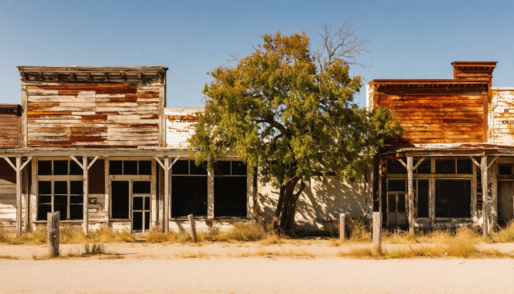
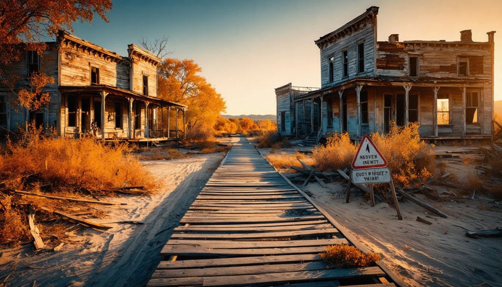
Toyah: Where Ghostly Legends Meet Abandoned Streets
Toyah rises from the West Texas desert like a weathered monument to ambition gone silent. You’ll find fewer than 100 souls wandering streets that once buzzed with cowboys, cattle traders, and railroad workers in the 1920s.
A desert ghost town where ambition withered—fewer than 100 residents remain among streets once thick with cowboys and commerce.
The 1912 schoolhouse stands skeletal against endless sky, while adobe storefronts crumble beside it—furniture still intact inside, as if residents vanished overnight.
Urban legends cling to this place like dust. Locals whisper about mysterious orbs hovering through darkness, and ghostly apparitions tied to Toyah’s violent past haunt the collective memory.
The 1906 lynching of “Slab” Pitts remains a dark stain, while feuds between ranchers left bodies in their wake. In 1896, the violence reached its peak when Texas Ranger and Reeves County Sheriff Bud Frazer was shot and killed by Jim Miller, who was later hanged in Oklahoma.
Walk these abandoned streets where artesian springs once promised prosperity, and you’ll understand how quickly dreams dry up under the relentless Texas sun. Nature dealt its own blow when a devastating tornado in 2004 leveled many downtown buildings, including the historic bank that once anchored Front Street.
Indianola: Hurricane-Ravaged Coastal Ruins
You’ll discover Indianola’s tragic story etched into the coastal landscape, where two catastrophic hurricanes—first in 1875, then the final blow in 1886—erased what was once Texas’s second-largest port from existence.
Fall’s mild temperatures and lower humidity make it the ideal season to explore the weathered historical marker and La Salle statue that stand as lonely sentinels over a town now claimed by Matagorda Bay’s waters.
Walking this haunting shoreline, you’ll trace the footsteps of over 5,000 residents who watched their thriving seaport vanish beneath storm surge and flames, leaving only submerged foundations visible at low tide.
Historic Seaport’s Violent End
Where Matagorda Bay now swallows the ruins of Indianola’s original courthouse 300 feet offshore, you’ll find only murky water concealing what was once the Queen City of the West. This thriving seaport of 5,000 souls met its violent end through two devastating hurricanes that left nothing but underwater shipwreck exploration opportunities and proof to relentless coastal erosion.
The destruction unfolded in brutal succession:
- 1875 Category 3 Hurricane: 115 mph winds and 145 mph gusts obliterated three-quarters of buildings, killing 270 residents and washing boats 9 miles inland.
- 1886 Final Blow: 150 mph winds and 15-foot storm surge leveled all but two structures, sparking fires that consumed what remained.
Complete Abandonment: Survivors relocated entire homes to Port Lavaca and Victoria, leaving Galveston to claim Texas’s maritime supremacy.
Today’s barren coast holds only fishing shacks where prosperity once reigned.
Fall Exploration Conditions
Unlike most Texas ghost towns where you’ll walk dusty streets past weathered buildings, Indianola demands an entirely different approach—its ruins lie submerged beneath 15 feet of Matagorda Bay’s murky waters. You’ll need a boat to explore the shallow bay covering foundations and railroad remnants, but prepare for fall’s unpredictable Gulf weather.
Hurricane season peaks September through November, threatening the same coastal exposure that destroyed the town in 1886.
The rewards justify the risks. While autumn foliage appears sparse in this windswept landscape, wildlife sightings abound at the nearby bird sanctuary, where migratory species congregate. Access the coastal cemetery and historical markers via surrounding roads during mild fall temperatures. Check forecasts obsessively—tropical storms materialize quickly here, and you’re entirely exposed without shelter.
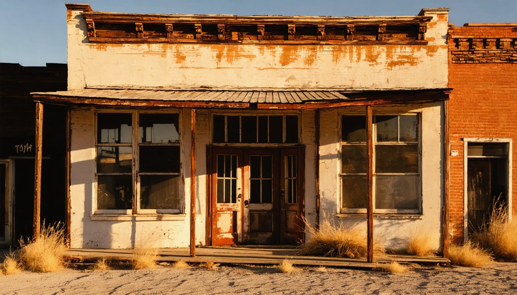
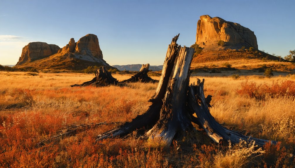
Medicine Mound: Sacred Hills and Fire-Scarred History
The town that borrowed their name prospered until catastrophe struck:
- 1932-1933 fires reduced thriving businesses to ash, leaving only two cobblestone structures standing.
- Economic collapse from the Depression, drought, and 1938 snowstorms emptied the community.
- Railway abandonment sealed Medicine Mound’s fate by the 1950s.
Today you’ll find photogenic ruins along Spur FM 91, with westward views of those enduring mounds where Comanche elders still gather annually.
Bluffton: The Submerged Town Beneath Lake Whitney
Beneath Lake Buchanan’s shimmering surface lies a complete 1850s settlement—pecan orchards, cotton gin, general store, and all—drowned when Franklin D. Roosevelt’s New Deal brought the Buchanan Dam to Central Texas.
This submerged history becomes accessible during severe droughts, when water levels drop and you’ll discover tombstones, building foundations, and a baseball field emerging from the mud.
The Texas Historical Commission excavated during the 2009 resurfacing, uncovering metal tools, medicine bottles, and blacksmith equipment preserved underwater.
You’ll need to trek across lake peninsulas or book the Vanishing Texas River Cruise to reach these ruins.
While lake archaeology reveals Bluffton’s past, remember—removing artifacts from this underwater graveyard is illegal, though witnessing it isn’t.
Planning Your Fall Ghost Town Adventure
When autumn’s first cool front sweeps across Texas, you’ll find perfect conditions for exploring abandoned settlements that summer heat renders nearly unbearable.
September through November delivers mild temperatures and extended daylight for steering remote backroads safely. Your adventure demands strategic planning:
Fall’s temperate days and lingering light create ideal windows for navigating Texas’s forgotten corners without summer’s punishing extremes.
- Route Selection: Link Terlingua’s mining ruins with Marfa’s mysterious lights, or circuit through Abilene’s Fort Phantom Hill and Thurber’s industrial remnants.
- Camping Options: Book Hipcamp sites near ghost town clusters—RV parks at Terlingua sit minutes from Big Bend trails, while coastal spots like Magnolia Beach position you for eastern explorations.
- Timing Advantages: October brings the Marfa Lights Festival and Día de los Muertos celebrations in Terlingua, where wildflower blooms frame crumbling adobe under a starry night sky.
Pack sturdy boots and embrace the open road.
Photography Tips for Capturing Abandoned Texas
Capturing Texas ghost towns through your lens transforms weathered abandonment into striking visual narratives—if you master fall’s unique atmospheric conditions. Golden hour bathes Lueders’ crumbling facades in warm light, while overcast skies provide perfect diffusion for detail shots.
Position your wide-angle lens using the rule of thirds at Glenrio’s Route 66 ruins, letting abandoned roads lead viewers through desolate storefronts.
Pack a tripod for nighttime illumination experiments at Chisos cemeteries during blue hour’s eerie glow.
Macro lenses reveal rust-streaked pumps and peeling paint textures that define Medicine Mound’s decay.
Don’t overlook wildlife photography opportunities—feral cats prowling Thurber’s smokestack area add haunting movement.
In post-processing, boost contrast and selectively desaturate for moody monochrome evoking Depression-era abandonment.
Safety Considerations When Exploring Ghost Towns
Before stepping through the weathered doorframe of any Texas ghost town structure, you’ll need to assess what lurks beyond Instagram-worthy decay—collapsing roofs that’ve surrendered to decades of neglect, floorboards rotted through by rain seeping through missing shingles, and walls that buckle under their own weight.
Beyond that crumbling doorway lies decades of structural surrender—roofs collapsing, floors rotting, walls buckling under their own neglected weight.
Safety gear essentials protect your exploration:
- Sturdy boots with ankle support navigate unstable mining ground and broken glass from vandalism
- Dust masks or respirators shield against lead contamination in industrial sites
- First-aid kit and GPS device for remote desert locations where cellular signals disappear
Emergency planning requires mapping exits before entering structures and informing someone of your itinerary.
Respect trespassing laws—fines reach $5,000 for unauthorized entry.
Texas’s abandoned properties demand vigilance, not recklessness.
Frequently Asked Questions
Are Ghost Towns in Texas Safe to Visit With Children?
You’ll find most Texas ghost towns safe for kids if you stick to accessible areas. Terlingua offers haunted stories and photography opportunities without danger. Avoid unstable structures, watch for wildlife, and let your family explore freely under supervision. Exploring annual festivals in Texas ghost towns can add an extra layer of excitement to your family’s adventures. These celebrations often highlight the unique history and culture of these once-thriving communities, providing a festive backdrop for your kids to learn and have fun. Be sure to check local event calendars for dates and activities that cater to families, making your visit even more memorable.
Do I Need Special Permits to Explore Abandoned Buildings in Texas?
You’ll need owner permission before entering abandoned buildings in Texas, as trespassing carries criminal penalties. Permitting requirements don’t exist statewide, but private property rules apply strictly. Always secure explicit consent to explore safely and legally.
What’s the Best Time of Day to Visit Ghost Towns in Fall?
Morning offers the best ghost town experience—cooler temperatures and soft light create perfect timing considerations for exploration. You’ll capture stunning photography tips with dawn’s golden glow illuminating weathered structures, while fewer crowds let you wander freely through history.
Can I Camp Overnight at Texas Ghost Town Sites?
You’ll need to camp at designated Texas State Parks nearby, as 91 state parks offer camping facilities. Practice campfire safety in established rings, then explore historical markers at ghost towns during daylight hours for your adventure.
Are There Guided Tours Available for These Ghost Towns?
You’ll find guided exploration through ghost tour companies in Granbury, Galveston, and Fort Worth, though they focus on haunted historic districts rather than abandoned ghost towns. Historical preservation efforts limit actual ghost town access to self-guided visits only. To truly experience the eerie charm of forgotten places, you might choose to explore abandoned towns in Texas, where remnants of the past tell vivid stories. Each dilapidated building and empty street provides a glimpse into the lives once lived there, inviting adventurous spirits to uncover their mysteries. While some locations may be challenging to access due to preservation rules, many sites remain open to intrepid explorers eager to connect with history.
References
- https://www.texashauntedhouses.com/fall-attractions/
- https://www.hipcamp.com/journal/camping/texas-ghost-towns/
- https://www.traveltexas.com/articles/post/spooky-roadtrip/
- https://www.tripadvisor.com/Attractions-g28964-Activities-c47-t14-Texas.html
- https://www.ghostsandgetaways.com/ghost-towns
- https://www.southernthing.com/ruins-in-texas-2640914879.html
- https://www.youtube.com/watch?v=_ndTmBBAC1I
- https://www.texasescapes.com/TOWNS/Texas_ghost_towns.htm
- https://www.legendsofamerica.com/tx-terlingua/
- https://www.utahsadventurefamily.com/terlingua-ghost-town-texas-big-bend/


