You can explore Flagstaff’s submerged streets beneath Maine’s largest man-made lake, where cellar holes emerge when water levels drop. Trek to Riceville in Hancock County, where a tannery once employed 75 people before burning in 1905—foundation stones and a headstone-less cemetery still mark the spot. Follow overgrown rail trails to find Askwith near Greenville, or discover Freeman’s Revolutionary War-era settlement sites. Each location offers moss-covered foundations, scattered industrial remnants, and stories of communities lost to floods, fires, and economic decline that shaped Maine’s wilderness frontier.
Key Takeaways
- Flagstaff lies submerged beneath Maine’s largest man-made lake, with remnants visible when water levels drop near Eustis.
- Riceville in Hancock County features tannery foundations, a headstone-less cemetery, and reports of paranormal activity among overgrown ruins.
- Askwith (Tarrantine) between Greenville and Rockwood offers old rail trails and abandoned railroad worker outposts reclaimed by wilderness.
- Fort Gorges and Battery Steele provide accessible military ghost town experiences with intact granite blocks and concrete bunkers.
- Freeman’s repeal of incorporation in 1937 marks Maine’s rural depopulation, though specific visiting locations require further research.
Flagstaff: The Town Beneath the Lake
In the early 1800s, settlers carved out a new life along Maine’s Dead River, drawn to the rich floodplain soil that promised bountiful harvests. They named their town after a flagpole Benedict Arnold’s men erected during their historic march.
Mills powered by Flagstaff Pond’s outlet drove prosperity through timber harvests, creating a thriving community.
But Central Maine Power had different plans. In 1950, Long Falls Dam‘s gates closed, drowning the century-old settlement beneath what’s now Maine’s largest man-made lake.
You’ll find residents threw one final celebration—300 people gathering for Old Home Days in July 1949, toasting their town’s legacy before the waters rose. Displaced families relocated to nearby towns like Eustis and Stratton, carrying their memories to new communities. The Flagstaff Memorial Chapel Association preserves the valley’s history through commemorations and historical records.
Today, Flagstaff Lake offers prime wildlife habitats among its submerged streets. The geological features beneath these waters hold stories of sacrifice for progress.
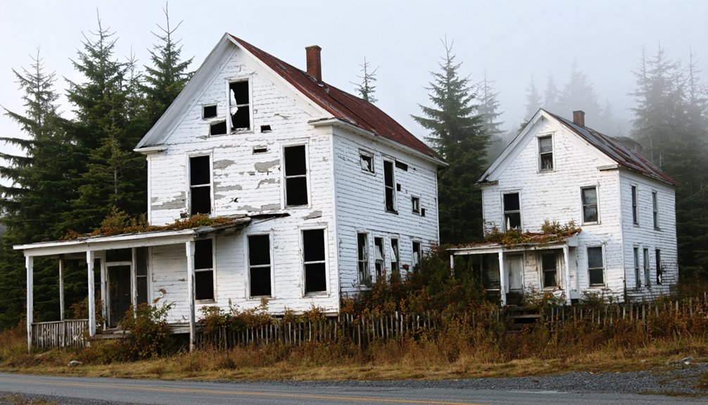
Freeman: Revolutionary War Settlement Lost to Time
You’ll find Freeman’s origins rooted in tragedy—Massachusetts granted this land to survivors after British forces burned Portland (then Falmouth) to ashes during the Revolutionary War.
By 1840, these resilient settlers had built a thriving community of 838 people, clearing vast tracts for Maine’s most expansive sheep farms.
The town couldn’t survive the Civil War’s toll and industrialization’s pull, though, losing so many residents that Freeman repealed its own incorporation in 1937.
Among the notable families who shaped the region, the Freemans maintained deep roots stretching back to colonial governance, with descendants serving in public office and contributing to Maine’s development.
By 1930, the population had plummeted to just 219 residents, foreshadowing the town’s inevitable dissolution.
Revolutionary War Land Grant
Deep in Oxford County, Freeman Township stands as a tribute to Massachusetts’ complicated promises to Revolutionary War veterans. You’ll discover revolutionary land grants weren’t the noble reward they seemed—soldiers waited until 1801 while Massachusetts handed prime territory to cotton manufacturers and Nova Scotian allies first.
The 280,000-pound compensation program created buffer settlements in Maine’s wilderness, though veteran settlement history reveals a darker truth: many grants landed in swamps and undesirable lots.
When you explore Freeman’s remnants today, you’re walking through evidence of broken promises. Veterans filed applications through Maine’s Land Office between 1835-1838, decades after wealthier recipients claimed choice acreage.
These Oxford County grants concentrated soldiers into marginal lands, creating communities destined to struggle. The Land Agent managed the application records and issued certificates to approved veterans and widows during this period. The earliest land grants between 1776-1780 established patterns of distribution that would disadvantage common soldiers for generations. Freeman’s ghostly presence reminds you that freedom’s defenders rarely received freedom’s rewards.
Population Decline and Deincorporation
After Freeman’s incorporation in 1808, the settlement’s fortunes peaked at 838 residents by 1840—a brief golden age when sheep grazed across thousands of cleared acres and local farms competed with Maine’s largest operations.
Then came the slow fade you’ll recognize from countless rural communities: the Civil War pulled young men away, the Industrial Age promised better wages elsewhere, and population trends turned sharply downward.
By 1900, only 397 souls remained. By 1930, just 219. Unlike typical urban decay with its crumbling infrastructure, Freeman simply emptied out—jobs vanished, farms failed, and families scattered. Freeman’s collapse mirrors patterns still visible today, as young people leave rural Maine for education and employment opportunities. This isn’t ancient history—more than half of Maine’s towns experienced population decline between 2007 and 2008 alone.
In 1937, the state officially repealed the town’s incorporation, erasing Freeman from Maine’s municipal map. You’re looking at what happens when opportunity migrates and nobody returns.
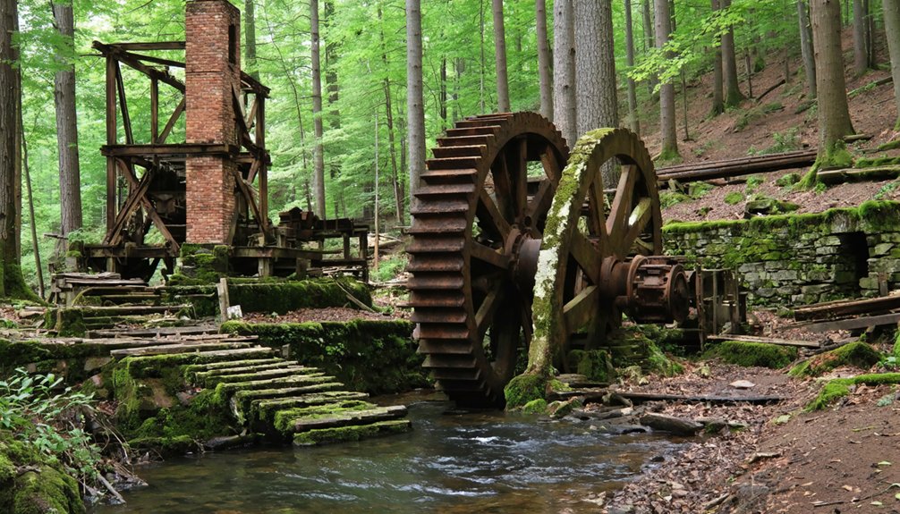
Riceville: Mills and Memories in Hancock County
Hidden among the forests of Hancock County’s Township 39, Riceville once hummed with the rhythmic pulse of industrial ambition. The Shaw brothers’ 1879 tannery transformed raw buffalo hides into sole leather, creating a self-contained world where 75 souls lived and worked.
Rural architecture dotted the landscape—boarding houses, a schoolhouse teaching 21 pupils, and a post office connecting residents to civilization beyond.
Then December 30, 1905 brought flames that devoured everything.
Folklore stories claim you’d find bodies in streets, victims of cholera or tannery poisons. Truth’s simpler: when work vanished, so did people.
By 1910, silence replaced industry. After Buzzell and Rice acquired the operation from the Shaw brothers in the 1880s, the village experienced a period of expansion before its ultimate demise.
Today you’ll discover overgrown foundations and a cemetery without headstones. Access remains challenging due to swampy terrain and beaver dams blocking the old roads. Ghost hunters report voices in wind, EMF readings spiking where workers once labored.
The forest reclaims what ambition built.
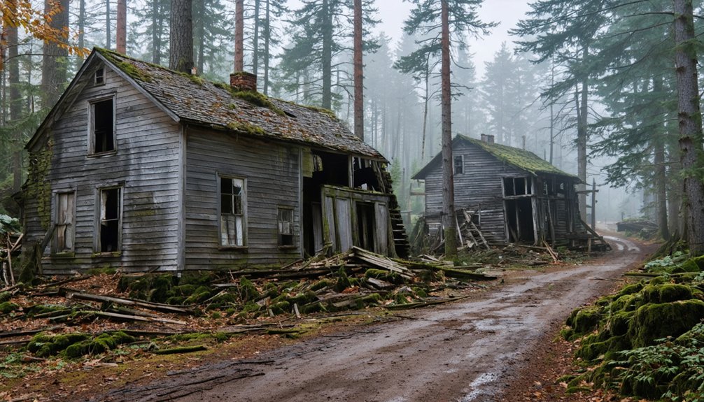
Askwith (Tarrantine): A Forgotten Settlement in Piscataquis County
Between Greenville and Rockwood, where Misery Knob casts shadows across Piscataquis County’s wilderness, Askwith emerged as a railroad settlement that couldn’t quite decide on its own name.
You’ll find this place’s identity crisis written into Maine’s historical naming conventions—first Askwith, then Tarratine, creating enough confusion to obscure its own disappearance.
The settlement operated a post office before 1895, serving railroad workers who’d later abandon the tracks you can now follow on ATV trails.
Ghost town branding works when locations maintain consistent identities, but Askwith’s multiple names erased its coordinates from collective memory: 45°36′58″N 69°40′20″W.
Today, you’re tracking remnants between Taunton Academy Grant and Rockwood—a forgotten outpost where wilderness reclaimed what railroads briefly tamed.
Davidson: The Lumber Baron’s Lost Empire
You’ll find Davidson’s story reads like a cautionary tale of ambition swallowed by wilderness. Ora Gilpatrick carved an entire industrial township from the forests straddling Aroostook and Penobscot Counties—complete with sawmill, clothespin factory, railway station, and wooden sidewalks connecting dozens of buildings.
Gilpatrick’s Industrial Township Empire
In 1901, Ora Gilpatrick transformed an entire Maine township into his personal industrial kingdom, constructing what would become one of the state’s most ambitious lumber empires from scratch. His urban planning vision materialized through a sawmill, clothespin factory, and cone-shaped scrap burner connected by rail lines that hauled timber and finished products to the B&A Railway station.
The industrial architecture featured coordinated operations—raw logs entered the sawmill, emerged as processed lumber, and transformed into manufactured goods.
You’ll find remnants of his complete community: boarding houses separated by gender, a general store, blacksmith shop, church, and entertainment hall with wooden sidewalks connecting everything. Gilpatrick built homes for his sons here, believing his empire would last generations.
Decline and Abandonment
Gilpatrick’s confidence in his industrial empire proved tragically misplaced. Resource exhaustion struck swiftly—within decades, the forests that seemed limitless vanished.
You’ll find his settlements followed a predictable pattern of corporate abandonment:
- Hastings (1890s-1918): Produced 65,000 board feet daily before 1903 forest fires destroyed operations.
- West Athens: Stripped so bare “a crow flew over here it had to keep goin’ three more miles before it could find so much as a branch to set up on.”
- Hurricane Island (1915): Workers evacuated within days of bankruptcy announcement.
- Multiple mills: Ceased operations within 10-30 years of establishment.
When profits disappeared, so did the company. Workers scattered, buildings were scavenged for lumber, and only foundations remained—testament to exploitation’s inevitable end.
Ligonia Village: South Portland’s Industrial Remnant
Walk Ridgeland Avenue, formerly High Street, where Brown’s Hill rises above what became factory grounds after Henry Bodge purchased the Brown family homestead in 1833.
The Portland Kerosene Oil Company once dominated this landscape, replacing colonial farms with manufacturing might.
Now you’ll discover solid starter homes occupying land where industrial smoke once darkened the sky.
The village’s absorption into greater South Portland erased its distinct identity, leaving only whispers of commerce beneath suburban normalcy—a ghost town hiding in plain sight.
What Remains: Exploring Physical Traces of Ghost Towns
When you walk through Maine’s ghost towns, you’ll find cellar holes outlined by moss-covered foundation stones. Their rectangular shapes still hold the footprint of family kitchens and parlors.
At low water in Flagstaff Lake, rusted kitchen utensils emerge from the shallows alongside street grids that once guided horse carts and Model Ts.
The concrete bunkers at Battery Steele stand firm, with their gun mounts still bolted to floors.
Fort Gorges’ granite blocks—each weighing tons—crumble grain by grain into Casco Bay’s cold water.
Foundations and Mill Structures
Maine’s ghost towns reveal themselves through crumbling foundations and skeletal mill structures that pierce the forest floor like architectural fossils. You’ll discover these remnants where water mills once powered communities, now reclaimed as wildlife habitats.
At Dead River’s floodplain, gristmill and sawmill foundations mark Flagstaff Village’s industrial heart. Riceville’s tannery foundations chart a mid-19th-century mill town layout. Meanwhile, Davidson’s machinery bases tell stories of lumber operations.
Key foundation types you’ll encounter:
- Stone cellar holes from residential structures
- Industrial mill foundations with machinery mounts
- Tannery building remnants near water sources
- Church and public building bases
Apply basic archaeological techniques when exploring—photograph positioning, note construction materials, and respect these sites. You’re walking through history that conventional maps forgot.
Relocated Buildings and Graves
Before floodwaters swallowed Flagstaff Village in 1950, residents orchestrated one of Maine’s most dramatic community relocations—loading entire houses onto trucks, exhuming family graves, and establishing New Flagstaff in nearby Eustis.
You’ll find Flagstaff Cemetery along Route 27 today, containing moved graves from the original town’s burial grounds. Dead River Plantation families faced similar upheaval, packing belongings as legal notices arrived and controlled fires consumed what couldn’t be saved.
They celebrated final Old Home Days on July 4, 1949, before scattering to Stratton and Eustis. Freeman Township left only its hidden cemeteries behind—no buildings made the journey when the town dissolved in 1937.
These relocated communities prove Maine’s ghost towns didn’t simply vanish; determined residents carried their homes and ancestors forward.
Among these haunting remnants are the haunted ghost towns in Maine that provide a glimpse into the state’s rich history. Visitors often find themselves captivated by the eerie atmosphere, exploring the remnants of once-thriving settlements. Each abandoned building tells a story, inviting exploration and reflection on the lives that once filled these now-silent streets.
in addition to the charm of these historical sites, winter exploration in ghost towns offers a unique perspective on their enduring beauty. As the snow blankets the landscape, the skeletal remains of buildings are further highlighted, creating a striking contrast against the white backdrop. Visitors can experience the peace that comes with solitude in these forgotten places, fostering a deeper connection to Maine’s past.
Industrial Equipment and Remnants
Scattered across Maine’s abandoned settlements, rusted machinery and crumbling foundations tell stories that wooden structures never could. You’ll discover industrial equipment that once powered entire communities, now reclaimed by forest and time.
Industrial Remnants Worth Exploring:
- Keddy Mill’s transformers and power systems along the Presumpscot River—massive equipment left frozen mid-operation.
- Madrid’s mining machinery scattered near accessible quarry pits and shaft openings.
- Davidson’s timber processing gear—saws, conveyors, and metal fragments marking the lumber operation’s footprint.
- Riceville’s factory remnants—barrel hoops, hand pumps, and wagon parts from the tannery’s 1905 demise.
These factory remnants offer tangible connections to Maine’s extractive industries. You’re free to wander among fieldstone foundations and rusted mechanisms, piecing together the industrial ambitions that once drove these remote settlements.
How Maine’s Ghost Towns Met Their Fate
The villages that once dotted Maine’s landscape didn’t simply fade away—they were erased by forces beyond their residents’ control. Central Maine Power’s dam projects forced entire communities like Flagstaff to abandon their homes, culminating in a final July 4th celebration before 1950’s floodwaters submerged everything.
Freeman’s sheep farmers watched their economy collapse as factories lured workers away, leaving cleared acres to rewild.
Riceville vanished overnight when its tannery burned on December 31, 1905—insurers paid, but owners walked away.
Industrial expansion devoured Ligonia, pushing oil tanks where homes once stood.
The environmental impact reshaped entire watersheds, while historical preservation remains nearly impossible for towns drowned beneath reservoirs.
You’ll find timber companies stripped abandoned farms bare, leaving nothing but tax sale records and overgrown foundations.
Planning Your Ghost Town Adventure in Maine
While some ghost towns welcome you with paved roads and interpretive signs, Maine’s abandoned settlements demand different levels of commitment from their visitors. You’ll need strategic planning to explore these architectural remnants where local legends still whisper through crumbling foundations.
Venturing into the abandoned towns in rural Maine offers a glimpse into a forgotten era, where nature reclaims its territory amidst the decay. Each journey through these eerie landscapes reveals stories etched into the very fabric of the buildings and the remnants of life once lived. As the wind rustles through the overgrown streets, it becomes clear that these ghostly places hold a timeless allure for those willing to listen.
Your successful ghost town expedition requires:
- Seasonal timing – Fall brings October candlelight tours at Fort William Henry, while harsh winters obscure Riceville’s cellar holes beneath snow.
- Permission verification – Many sites rest on private property or state land requiring access approval.
- Essential gear – Pack comfortable hiking shoes, flashlights, water, insect repellent, and cameras for capturing unexplained phenomena.
- Safety protocols – Inform others of your plans for remote locations with limited cell service, and watch for hidden cellar holes in overgrown terrain.
Respect these abandoned spaces while satisfying your wanderlust.
Preserving the Stories of Maine’s Abandoned Communities
Beneath towering pines and over moss-covered foundations, you’ll discover that Maine’s ghost towns survive not just as physical remnants but as stories passed down through generations—tales that shift between documented fact and local legend with each retelling. Riceville’s cholera legend masks the truth of its 1905 tannery fire, while Flagstaff’s Captain Wing supposedly built an ark against inevitable flooding. These local legends protect memory when buildings crumble.
Preservation challenges mount as nature reclaims these sites. Freeman’s stone foundations sink deeper into forest floor. Askwith’s few remaining structures battle Maine winters. When Flagstaff Lake’s water drops, you’ll glimpse submerged remnants—fleeting windows into 1950. Document what you find. Photograph crumbling chimneys. Record coordinates. You’re not trespassing on history; you’re keeping it alive.
Frequently Asked Questions
Are There Any Guided Tours Available for Maine’s Ghost Towns?
Maine offers no dedicated ghost town tours, but you’ll find historical preservation efforts at abandoned sites you can explore independently. These forgotten places provide incredible photography opportunities where you’re free to wander crumbling foundations and imagine past lives.
Some of the most intriguing ghost towns to explore in Maine include places like Lyman, where remnants of old factories still stand, and the eerie tranquility of the Mahoosuc region. As you meander through these historic sites, you may come across relics that tell the stories of those who once called these towns home. Each visit offers a chance to connect with Maine’s rich history in a uniquely haunting way.
As you make your way through these desolate landscapes, be sure to explore the ghost towns of Maine, where time seems to stand still. The stories held within the walls of these abandoned buildings and the silence that envelops them invite a sense of wonder and reflection. Whether you’re an avid photographer or a history enthusiast, these hidden gems offer a poignant glimpse into the past, waiting to be discovered.
Is It Legal to Take Artifacts From Abandoned Ghost Town Sites?
No, you can’t legally take artifacts from ghost towns. Legal considerations strictly prohibit removing historical items from protected sites. Cultural preservation depends on leaving everything untouched—take only photographs, respecting Maine’s heritage for future adventurers to discover.
What Safety Precautions Should Visitors Take When Exploring Ghost Towns?
You’ll need sturdy boots and respirators—I once cut my hand on rusted metal at an 1800s mill site. Watch for wildlife hazards like nesting birds, and respect historical preservation by documenting, not disturbing, these fragile remnants of freedom.
Which Ghost Towns Are Most Accessible During Winter Months?
You’ll find Freeman and Riceville most accessible for winter exploration. Freeman’s near groomed ski resort roads, while Riceville offers excellent snowshoe routes through deep woods. Both provide freedom for winter hiking without requiring snowmobile access or extreme backcountry skills.
Do Any Ghost Towns Have Camping Facilities Nearby for Overnight Visits?
You won’t be roughing it completely—several ghost towns offer nearby camping. Perkins Township provides waterfront campsites among deserted landmarks, while Freeman and Flagstaff connect you to Maine’s hidden histories through established campgrounds with lean-tos and trail access.
References
- http://strangemaine.blogspot.com/2012/02/ghost-towns-of-maine.html
- https://en.wikipedia.org/wiki/List_of_ghost_towns_in_Maine
- https://www.mooseriverlookout.com/post/ghost-towns-in-maine-9-fascinating-places-that-rose-fell
- https://b985.fm/6-maine-ghost-towns-you-never-knew-existed/
- https://www.mainememory.net/record/108671
- http://freepages.rootsweb.com/~gtusa/history/usa/me.htm
- https://ghost-towns.close-to-me.com/states/maine/
- https://www.onlyinyourstate.com/nature/maine/lost-city-flagstaff-lake-me
- https://www.mainesnorthwesternmountains.com/things-to-do/sight-seeing-scenic-drives/the-valley-below
- https://darkdowneast.com/flagstafflake/