You’ll find Minnesota’s most accessible ghost towns at Forestville State Park, where 1850s buildings stand preserved near Preston, and Nininger in Dakota County, marked by the 1858 Good Templars Hall just 17 miles south of St. Paul. Wasioja offers haunting limestone ruins including a Civil War-era seminary, while Radium‘s grain elevator still towers over northwestern prairie. For adventurous explorers, Elcor’s mining foundations hide among Mesabi Range forests, and Carver County’s scattered settlements reveal foundations along former steamboat routes—each location holds deeper stories of boom, decline, and the wilderness reclaiming what settlers abandoned.
Key Takeaways
- Forestville offers preserved 19th-century buildings open Memorial Day through October, featuring a blacksmith shop and general store from the 1850s.
- Nininger features Good Templars Hall built in 1858 and historical markers near St. Paul, accessible as scattered remnants along the Mississippi.
- Wasioja contains rehabilitated limestone structures including an 1855 recruiting station and seminary ruins preserved as a park with outline arches.
- Elcor on the Mesabi Iron Range shows mining town foundations and industrial remnants at coordinates 47.5167, -92.4167 from the 1900s-1960s era.
- Carver County settlements include Bongards Creameries, West Union church, and Scandia Cemetery with minimal tourism development preserving historical authenticity.
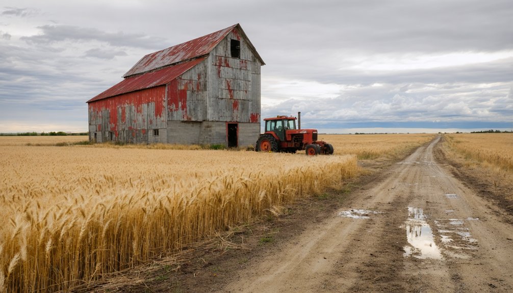
Forestville: A Preserved 19th Century Settlement
When Robert Foster rode into the Root River valley during the summer of 1853, he couldn’t have imagined that the town he’d help build would someday freeze in time like a photograph.
You’ll find Forestville an hour south of Rochester, where 150 residents once filled its sawmills, blacksmith shop, and bustling general store. The 1868 railroad bypass killed the town’s heartbeat—population crashed from 150 to 68 within two years.
By 1889, the Meighen family owned everything, transforming Forestville into their private farming empire. Farmers who defaulted on credit secured by mortgages gradually lost their land to the Meighens during the town’s economic decline.
Today’s historic preservation lets you walk through the general store and homestead from Memorial Day through October. The settlement officially became a ghost town around 1910 after the last remaining businesses shut their doors.
While local ghost stories whisper through the cemetery and former distillery sites, you’re free to explore authentic frontier commerce without velvet ropes or sanitized narratives.
Elcor: Mining Company Town of the Mesabi Iron Range
When you explore Elcor’s remaining foundations and slag piles, you’ll notice how the company’s control extended beyond the mines. They owned every house, store, and even the land beneath residents’ feet.
Walking these reclaimed grounds where over 100 worker homes once stood, you can still trace the grid of dirt roads that separated Croatian families from Finnish neighbors, all living in identical company-built structures.
Today’s landscape offers little more than concrete remnants and scattered debris, yet these fragments reveal how mining corporations shaped entire communities before erasing them for profit. The town operated from 1900 through the 1960s, providing housing and services for up to 800 residents who worked the iron deposits of Minnesota’s Mesabi Range. The last mine closed in 1954, triggering the evacuation orders that would empty Elcor within two years.
Company-Built Worker Housing
During the late 1890s, you’d have witnessed the Minnesota Iron Company transform a patch of northern Minnesota wilderness into Elcor, a meticulously planned company town designed to house 800 workers who extracted iron ore from the Mesabi Range‘s rich deposits.
The company housing created a self-contained worker community where miners lived steps from the Elba and Corsica mines. You’ll find remnants of this engineered settlement—foundations marking where families slept, spaces where the company store once supplied provisions, and the schoolhouse location where children studied while their fathers worked underground.
This wasn’t charity; it was calculated efficiency. The company controlled everything, from your paycheck to your rent. The town’s name itself combined elements from its two main mines—Elba and Corsica—reflecting the corporate identity that shaped every aspect of community life. The Duluth, Missabe and Northern Railroad, formed in 1891, connected these remote mining operations to the shipping docks at Duluth, enabling the transport of extracted ore that sustained the company town’s existence. Today, only slag piles and crumbling concrete hint at this industrial experiment in corporate paternalism, now reclaimed by encroaching forest.
Land Ownership Structure
The Minnesota Iron Company’s president Don H. Bacon envisioned something unusual when he platted Elcor in 1897—a town where you’d own your home but not the ground beneath it.
This peculiar arrangement meant the company maintained absolute control over the land while miners built their lives atop borrowed earth.
You’ll find this wasn’t uncommon on the Mesabi Range, where mining regulation favored corporate interests over individual property rights.
When Pickands Mather ordered evacuation in 1954, that land ownership structure showed its true nature—residents had to leave everything behind for land reclamation.
The company simply reclaimed what was always theirs. The town maintained its own law enforcement to oversee the community and ensure order among the diverse immigrant population. Today, only foundations remain where nearly 1,000 people once called home, a stark reminder of corporate dominance.
Visiting Elcor Today
If you’re searching for Elcor’s remains today, you’ll discover a landscape where nature and industry wage a quiet battle for dominance. Boreal forest swallows what little historic architecture remains—foundations peek through moss, slag piles stand as rusty monuments. The site sits between McKinley and Gilbert, coordinates 47.5167, -92.4167, where over 100 houses once thrived.
Summer visits work best; you’ll need an hour to explore the moderate terrain. Follow dirt paths where boardwalks rotted decades ago, trace outlines of the company store and churches. Inland Steel’s 1993 overburden from Minorca Mine towers nearby, testament to the land’s continued mining purpose.
This ecological recovery tells its own story—trees reclaiming what miners carved away, leaving you free to wander through Iron Range history.
Nininger: The Forgotten Township Near Minneapolis
You’ll find Nininger’s ghost in section 18 of Dakota County, seventeen miles south of St. Paul, where cornfields now blanket what was once a bustling riverside settlement of nearly 1,000 souls.
The Mississippi River still flows past these coordinates—44°46′09″N 92°54′08″W)—but tractors have replaced steamboats.
Only two bronze plaques interrupt the farmland to mark where Good Templars Hall and Ignatius Donnelly‘s home once stood.
A solitary historical marker serves as your primary guide to imagining the boom town that collapsed as spectacularly as it rose, leaving behind more legend than lumber. Founded in 1856 by Ignatius Donnelly and John Nininger, the settlement was platted with 3,800 lots on the south bank of the Mississippi, northwest of Hastings.
Donnelly promoted the town through his “Immigrant Aid Journal”, attracting settlers with visions of a utopian community built on honest labor and education.
Location and Current Status
Perched on a high bank above the Mississippi River, Nininger occupies a dramatic stretch of bluffland four miles northwest of Hastings in Dakota County, just twenty-five miles south of St. Paul.
You’ll find it tucked between a river bend and Highway 55, where steamboats once promised prosperity that never materialized.
Today, Nininger Township maintains 865 residents who’ve kept the community alive.
The renovated Good Templars Hall, serving as Town Hall since 1951, stands as the area’s crown jewel of ghost town preservation.
Built in 1858, this structure earned National Register of Historic Places designation in 1980.
While most boom-era buildings vanished, these historic landmarks remind you that dreams of railroad terminals and county seats once flourished here before the Panic of 1857 shattered everything.
The site was originally known as Bluff Landing, then Bassetts Landing, before receiving its current name when John Nininger and Ignatius Donnelly established their planned community in 1856.
What Remains Today
Standing near the Nininger Township Town Hall, you’ll encounter a solitary historical marker that tells the story of what might’ve been. This monument to historical preservation recounts Ignatius Donnelly’s 1856 pamphlet promoting Minnesota’s promise—a vision that transformed into ghost town legends.
The physical remnants you’ll discover include:
- Good Templars Hall (9965 124th Street East) – built 1858, served as schoolhouse until 1949, now on the National Register of Historic Places
- Donnelly home site plaque – marking where Minnesota’s Lieutenant Governor lived between Highway 55 and the Mississippi River bend until 1949
- Relocated structures – various Nininger buildings dismantled and moved downstream to Hastings after the 1863 abandonment
You’ll find these scattered traces between the river and modern roadways, silent witnesses to 700 speculative towns that vanished.
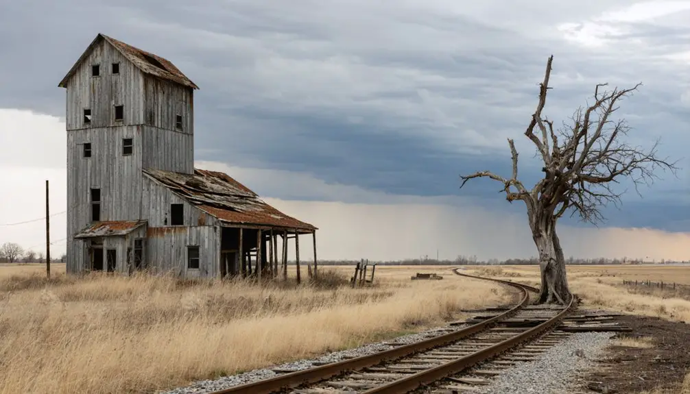
Radium: Agricultural Hub of Northwestern Minnesota
Deep in the fertile plains of Marshall County, Radium emerged in 1905 as a prairie settlement tied to the rhythms of grain harvests and steam whistles. You’ll find this Radium community where the Soo Line Railroad once promised prosperity, connecting isolated farmers to distant markets. The massive grain elevator still stands sentinel beside active tracks, now run by Northern Plains Railroad—a stark monument to agricultural history that shaped northwestern Minnesota.
Today, only twenty souls remain where a bustling townsite once thrived. The post office closed in ’84, and farmland’s steadily reclaiming what the railroad built. Yet Immanuel Lutheran Church, founded in 1897, still anchors the landscape 1.5 miles south, predating even the tracks. It’s raw, unvarnished testimony to frontier resilience you won’t find in sanitized history books.
Wasioja: Civil War Era Town With Seminary Ruins
Unlike most ghost towns that faded quietly into prairie obscurity, Wasioja died violently on a Georgian battlefield thirteen hundred miles away. When 59 of 60 men from Company C fell at Chickamauga’s Snodgrass Hill in September 1863, this thriving settlement of over 1,000 lost its heart.
A frontier town’s fate sealed not by drought or railroad, but by a single devastating hour on a distant Civil War hillside.
The economic decline accelerated as survivors relocated to Rochester, leaving limestone sentinels standing guard:
- The 1855 recruiting station—Minnesota’s only survivor—now rehabilitated after serving as jail, post office, and residence
- Andrew Doig’s stone schoolhouse, weathered but defiant
- Seminary ruins preserved as a public park, arches framing empty sky
You’ll find authentic architectural preservation here, not sanitized reconstruction. Walk these grounds where freedom-seekers once gathered, where America’s costliest war hollowed out a community’s future.
Exploring Carver County’s Collection of Abandoned Towns

Half of Carver County’s original settlements vanished between 1854 and 1900—twenty-one towns reduced to faded plat maps and overgrown foundations. You’ll find San Francisco’s remnants at Carver Rapids, where William Foster (a Donner Party survivor) established the county’s first seat before Minnesota River flooding drove everyone out by 1860.
Follow refuge trails to where steamboat passengers once filled his hotel and restaurant.
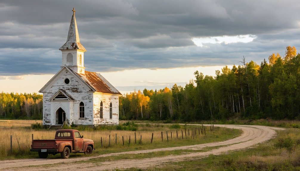
Historical preservation efforts maintain tangible connections: Bongards Creameries still churns butter where a town once stood, Hollywood’s sports complex marks another disappeared settlement, and West Union’s church watches over scattered homes.
Scandia Cemetery’s Swedish Baptist graves prove someone actually lived there—unlike pure paper towns that sold lots but built nothing.
Tourism development remains minimal here, giving you authentic exploration without commercialization clouding what time and bad planning couldn’t erase.
What Makes Minnesota’s Ghost Towns Unique
Minnesota’s ghost towns cling to rocky shorelines and sink into boggy wilderness where nature doesn’t wait for preservationists to show up.
As you explore ghost towns in Minnesota, you’ll encounter remnants of vibrant communities that once thrived amid the state’s natural beauty. Each location tells a unique story of history and transformation, inviting adventurous souls to traverse the quiet landscapes. These forgotten places hold an allure for those curious about the past and the passage of time.
You’ll find abandoned industries from iron mining to lumber operations slowly dissolving into forest floors, while Native settlements like Reyataotonwe stand as reminders that ghost towns predate European arrivals.
What sets these sites apart:
- Remote isolation – You’ll navigate unmarked roads 40 miles from civilization, earning your discovery
- Rapid reclamation – Forest Center disappeared so completely that even the 2011 Pagami Creek Fire needed to burn away overgrowth before revealing foundations
- Industrial diversity – From Mesabi Range mines to Mississippi River clay pits, each town died from different resource depletion
These places demand independence. No guided tours hold your hand through Finland’s graffitied ruins or Elcor’s boarded-up mine shafts.
Planning Your Minnesota Ghost Town Adventure
Before you pack your camera and lace up your hiking boots, you’ll need county-specific maps that reveal what mainstream travel guides ignore. Morrison County lists 20+ abandoned settlements along the Mississippi River, while Carver County’s 21 ghost towns hide near Mayer and Chaska. Visit ghosttowns.com for statewide routes, then contact local historical societies—they’ll share urban legends and ghost stories you won’t find online.
Spring and fall offer ideal conditions, avoiding northern Minnesota’s harsh winters and summer mosquito swarms. Bring sturdy boots for uneven terrain at sites like Forestville, plus GPS for unmarked locations.
Watch for open mine shafts near Elcore’s abandoned iron range. Respect private property—many remnants sit on working farmland. Always inform someone of your itinerary before exploring remote Morrison County sidings.
Frequently Asked Questions
Are Minnesota Ghost Towns Safe to Explore Without a Guide?
You can explore independently, but you’ll navigate aging structures and unstable floors alone. Historical preservation efforts vary widely, and local legends won’t warn you about hidden hazards. Bring proper gear, tell someone your plans, and trust your instincts.
Can Visitors Camp Overnight Near These Abandoned Town Sites?
You can dispersed camp on state forest land near ghost towns, staying 14-21 days depending on season. You’ll find freedom exploring historical preservation sites, though expect wildlife encounters. Remember: pack out everything, respect boundaries, and maintain 150 feet from water sources.
What Photography Equipment Works Best for Ghost Town Documentation?
Crumbling wood meets cutting-edge sensors—you’ll want mirrorless cameras with fast prime lenses (f/2.8 or wider) for Minnesota’s dim interiors. Pack portable tripods for long exposures and headlamps as lighting techniques to illuminate forgotten corners your camera gear captures.
Do Any Ghost Towns Charge Admission or Entrance Fees?
Most authentic ghost towns don’t charge admission—you’ll find free access to abandoned sites. However, locations with historical preservation efforts and visitor amenities like guided tours or maintained facilities may request donations or modest fees for upkeep.
Which Ghost Towns Are Accessible During Minnesota Winter Months?
You’ll find Forestville, Old Wadena, and Old Crow Wing accessible for winter exploration through maintained state park roads. Before venturing out, take safety precautions—pack emergency supplies and check conditions, since Minnesota’s brutal cold demands respect and preparation.
References
- https://en.wikipedia.org/wiki/List_of_ghost_towns_in_Minnesota
- https://www.carvercountyhistoricalsociety.org/ghost_towns.php
- https://freepages.rootsweb.com/~gtusa/history/usa/mn.htm
- https://thievesriver.com/blogs/articles/ghost-towns-in-minnesota
- https://www.minnesotahistory.org/post/a-complete-guide-to-the-ghost-towns-of-hennepin-county
- https://quickcountry.com/minnesotas-abandoned-ghost-towns/
- https://www.youtube.com/watch?v=5bCG6B2rzZY
- https://pbsnorth.org/show/minnesotas-lost-mining-towns/
- https://www.mngoodage.com/voices/mn-history/2019/07/a-ghost-town-turned-history-site/
- https://kdhlradio.com/forestville-named-the-creepiest-and-coolest-ghost-town-in-minnesota/