You’ll find Nebraska’s most compelling ghost towns scattered across prairie landscapes where history whispers through crumbling limestone facades and windswept cemeteries. Explore Steele City’s Victorian homes and spectral legends, wander St. Deroin’s relocated schoolhouse near the Missouri River bluffs, or stand among Mud Springs’ rifle pits from an 1865 conflict. DeWitty tells the remarkable story of African American homesteaders, while Roscoe’s grain elevators cast eerie shadows along the historic Lincoln Highway. Each abandoned settlement reveals forgotten chapters of pioneer determination, railroad prosperity, and the forces that transformed thriving communities into haunting remnants awaiting your discovery.
Key Takeaways
- Steele City offers Victorian homes, an 1882 church, historic cemetery, and the Salty Dog Saloon along its preserved main street.
- St. Deroin at Indian Cave State Park features a relocated schoolhouse and cemetery from the 1854 frontier trading settlement.
- Belvidere, an 1873 railroad stop on the Oregon Trail, showcases grain elevators and remnants of pioneer emigrant services.
- Rock Bluff preserves Nebraska’s oldest schoolhouse, the Naomi Institute building, now a museum highlighting pioneer educational history.
- Roscoe displays 1870s storefronts, grain elevators, abandoned barns, and a historic South Platte River bridge near Ogallala.
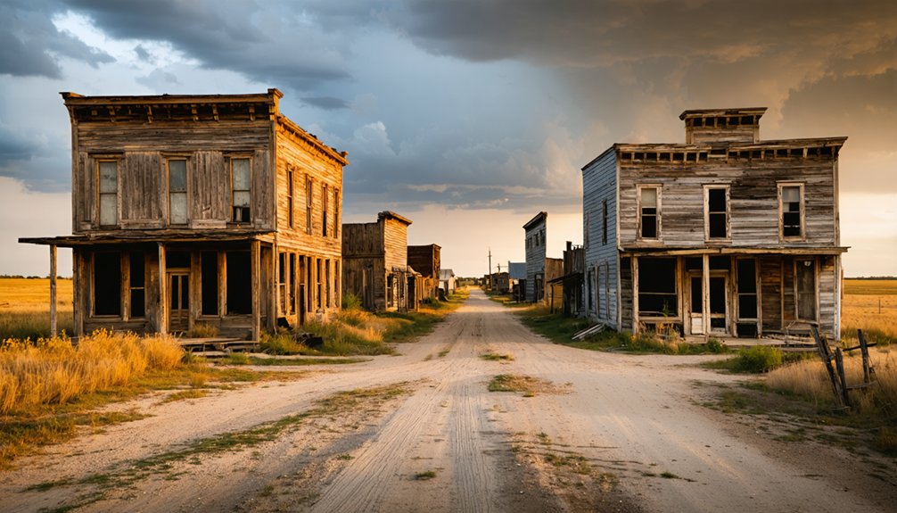
Steele City: a Living Ghost Town With Historic Charm
Nestled along Nebraska’s southern border where prairie winds sweep across abandoned storefronts and weathered limestone walls, Steele City stands as a haunting memento to the railroad boom that once transformed the Great Plains. Founded in 1873, this settlement thrived as a crucial shipping hub along the St. Joe and Western Railway.
A prairie ghost town where railroad dreams turned to limestone ruins and whistling wind through empty streets.
Today, just 47 residents maintain what remains of its mining heritage and architectural legacy.
You’ll discover the 1882 First Baptist Church, its Romanesque limestone facade sourced from Kansas quarries standing defiant against time. The church now serves as the Knights of Pythias hall, a testament to the community’s adaptation over the decades. Local legends speak of ghostly apparitions drifting through Victorian homes and the historic cemetery, where shadowy figures have been documented.
Walk the silent main street past the Salty Dog Saloon and crumbling storage buildings—this isn’t complete abandonment, but something more intriguing: a town suspended between past and present. As the railroad’s importance waned over the decades, commerce and population declined, leaving behind the remarkable historic buildings and architecture that make it worth visiting today.
St. Deroin: Abandoned Ferry Town Along the Missouri River
Where the Missouri River once carved its relentless path through southeastern Nebraska, St. Deroin thrived as a frontier trading hub from 1854. You’ll find its remains at Indian Cave State Park, where Joseph Deroin’s vision of creating another St. Louis crumbled beneath nature’s fury.
The town’s lifeline—a ferry connecting Iowa to Nebraska—powered commerce for three decades until the river shifted course. River transportation brought prosperity, with steamboats delivering goods and dreams to 300 residents by the 1870s.
But flood impact proved merciless. Devastating inundations in 1910 and 1911 swept away homes and businesses, while railroads bypassed the dying port.
Today, only the relocated schoolhouse and windswept cemetery mark where pioneers once bet everything on the river’s promise. The cemetery is believed to hold the founder’s remains, killed in 1858 over a debt dispute. By 1920, St. Deroin had become a ghost town, its empty streets surrendering to the wilderness that reclaimed the Missouri’s floodplain.
Belvidere: Railroad Stop on the Oregon Trail
While rivers brought fortune to some Nebraska settlements, the iron rails wrote different destinies across the plains. At Belvidere, you’ll discover where five historic routes converged—the Oregon Trail, Forty-Niner Trail, Union Pacific tracks, and two additional rail lines transforming this 1873 settlement into Nebraska’s ultimate crossroads.
Railroad expansion made this town thrive. Trains thundered through every 10-15 minutes, hauling grain, livestock, and freight to distant markets. The Union Pacific’s dual tracks attracted pioneers seeking opportunity along Big Sandy Creek‘s fertile banks. The railroad’s reach extended over 32,000 miles of track worldwide, making it the largest network of its kind.
Agricultural development flourished here, supported by grain elevators and blacksmith shops serving westward-bound emigrants. The town’s name, Belvidere, means “Beautiful to See” and reflected the optimism of settlers who built their community along the creek and railroad. At the Prairie Crossroads intersection, you’ll stand where wagon trains averaging sixteen miles daily once rolled past—where pioneer dreams met industrial progress beneath Nebraska’s endless sky.
Roscoe: Preserved Structures Along the Lincoln Highway
Seven miles east of Ogallala, the Lincoln Highway’s weathered pavement cuts through Roscoe—a settlement frozen between ghost town mythology and stubborn persistence.
You’ll find crumbling storefronts along US Highway 30, their wooden facades documenting decades of urban decay since Interstate 80 diverted transcontinental traffic elsewhere. These preserved structures—grain elevators, abandoned barns, and shuttered businesses—stand as unintentional monuments to architectural preservation, visible reminders of 1870s railroad prosperity. The historic bridge over the South Platte River connects Roscoe to surrounding areas, a vital crossing point that once served steam locomotives requiring water refills.
Roughly 62 residents still call this semi-ghost town home, including Keith County’s sheriff stationed near the local gas station. The community’s five-block footprint holds tight-knit neighbors who’ve watched commerce fade block by block. Like other desolate stretches across Nebraska, some travelers report an eerie atmosphere along these abandoned rural roads after dark.
The stories of bygone eras often linger in the air, especially in these abandoned places in Nebraska where memories of past lifestyles echo through the hollow structures. Visitors sometimes find remnants of old farms and forgotten schools, each telling a tale of resilience and loss. Despite the quiet desolation, these sites draw curious explorers eager to uncover the history embedded within their walls.
While you won’t find museum plaques or tourist infrastructure, Roscoe’s authenticity delivers what freedom-seekers crave: unvarnished history alongside Highway 30’s endless horizon.
Rock Bluff: Home to the Historic Naomi Institute
You’ll find Rock Bluff three miles east of Murray in the Missouri River bluffs, where the Naomi Institute‘s weathered brick walls still stand as Cass County’s oldest schoolhouse.
Founded in 1870 by Joseph Diven Patterson, this pioneering college once claimed the title of Nebraska’s leading educational institution before debt forced its sale just two years later. The two-story building opened its doors on September 1, 1870, overlooking the intersection of Rock and Squaw creeks. Advertisements promoted the school’s emphasis on high morals and the absence of dramshops in the virtuous environment.
Today, the Cass County Historical Society maintains this National Register landmark as a museum, preserving the legacy of a ghost town that once competed for the county seat but couldn’t survive the railroad’s westward shift.
Historic School Building Heritage
Standing as the sole survivor of Rock Bluff’s ambitious past, the Naomi Institute building represents a remarkable chapter in Nebraska’s pioneer education history. You’ll discover authentic school architecture from 1870, originally rising two stories before tornado damage reduced it to its current single-story form.
This brick structure measured 25 feet by 50 feet, perched on a south slope overlooking Rock and Squaw Creeks.
The building’s educational evolution spans from Professor J.D. Patterson’s ambitious college to a humble local schoolhouse after 1872. You can visit this National Register site through the Cass County Historical Society, which operates it as a museum.
It’s Nebraska’s oldest surviving schoolhouse in Cass County, offering you tangible connection to frontier learning when textbooks came free and determination built communities.
Geographic Location and Access
Nestled along the Missouri River‘s western banks in Cass County, Rock Bluff occupies a strategic location that once promised greatness but now marks Nebraska’s forgotten history. You’ll find this ghost town approximately three miles east of Murray.
Where agricultural development ultimately bypassed its riverfront advantage when railroads chose routes ten miles west.
Accessing Rock Bluff Today:
- Primary Route: Take Rock Bluff Road south from Plattsmouth (10 miles north), following year-round 2WD-accessible paths through grid 4.
- Coordinates: Navigate to 40°55′45″N 95°51′10″W in Section 9, township 10N, range 14E.
- Climate Considerations: Plan visits around typical Great Plains weather—hot summers and cold winters, with climate change intensifying seasonal extremes.
The site remains open for exploration, offering unrestricted access to the historic Naomi Institute schoolhouse and cemetery.
Educational Legacy and Preservation
When Joseph Diven Patterson opened the Naomi Institute’s doors on September 1, 1870, he transformed this Missouri River settlement into an unlikely beacon of frontier education. His $3,500 brick structure became Nebraska’s first higher education institution in Cass County, offering thorough instruction to all who sought knowledge regardless of gender.
Though debt forced Patterson’s departure in 1872, the building’s significance endured through its conversion to Rock Bluff School.
Today’s historic preservation efforts tell a story of resilience. After tornado damage reduced the school architecture to a single story, the Cass County Historical Society rescued this 1977 National Register landmark from obscurity.
You’ll find it perched above Rock Creek, the ghost town’s sole survivor—a museum preserving the educational aspirations that once flourished on Nebraska’s untamed frontier.
Among the exhibits, stories emerge from the remnants of abandoned towns in Nebraska history, bringing to life the dreams and challenges faced by early settlers. Visitors can explore artifacts that highlight the unique cultural heritage of these once-thriving communities. It’s a poignant reminder of how the landscape has changed, yet their legacy endures in the hearts of those who remember.
Mud Springs: Watering Hole on Pioneer Trails
Between the valleys of Lodgepole Creek and the North Platte River, a humble collection of springs once saved countless lives on the parched Nebraska plateau. You’ll find this oasis near Dalton, where buffalo once trampled seeps into muddy pools—giving the site its name. Ancient artifacts reveal Native traditions spanning centuries at this essential water source.
From 1830 onward, independent trappers discovered what indigenous peoples already knew. By the 1860s, Mud Springs became crucial infrastructure:
- Pony Express home station with log-and-sod buildings (1860-61)
- Stage coach stop along the Julesburg cutoff
- Telegraph outpost until 1869 railroad completion
In February 1865, Sioux and Cheyenne warriors attacked; nine soldiers defended from hastily-dug rifle pits you can still observe today at this National Register site.
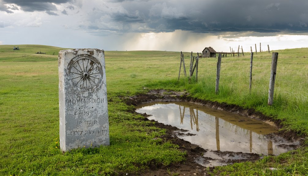
DeWitty (Audacious): African American Homesteader Settlement
Along a fourteen-mile stretch of the North Loup River, you’ll discover the remnants of Nebraska’s largest African American homesteader settlement, where 58 Black settlers proved claims to nearly 30,000 acres between 1906 and 1936.
This remarkable community—first called DeWitty, then Audacious—thrived with its own church, post office, store, and baseball team, fostering peaceful coexistence with white neighbors during an era of violent racial upheaval elsewhere in the state.
Today, a historical marker stands on Highway 83 in Cherry County, commemorating a settlement that challenged both the harsh Sandhills environment and the racial barriers of early twentieth-century America.
Unique Homesteader Community History
Deep in Nebraska’s Sandhills, where the North Loup River carved through Cherry County’s rolling grasslands, an extraordinary chapter of American history unfolded in 1907. DeWitty emerged as Nebraska’s largest African American homesteader settlement, established by former slaves who’d fled to Canada and their descendants seeking the promise of 640 free acres under the Kinkaid Act.
The community built remarkable infrastructure despite homesteading challenges:
- Educational Priority: Residents constructed a one-room schoolhouse by 1909, welcoming some neighboring white children.
- Economic Self-Sufficiency: Operated a church, store, barber shop, and post office while cultivating corn, potatoes, and sorghum.
- Cultural Identity: Formed the North Loup Sluggers baseball team, competing proudly against surrounding towns.
This African American history resonates with pioneers who fought through racial barriers to claim their piece of Manifest Destiny.
Cultural and Archaeological Significance
DeWitty’s archaeological footprint tells a powerful story of resilience that scholars and preservationists are still uncovering today. You’ll find remnants of settlement architecture that reveal how Black Canadian homesteaders adapted their building techniques to Nebraska’s harsh Sandhills environment.
The one-room schoolhouse foundation, church site, and scattered homestead ruins represent more than abandoned structures—they’re tangible evidence of families who claimed their autonomy against exclusionary policies.
Archaeological surveys document how residents blended Methodist and Baptist traditions with practical survival skills learned from Native traditions and Canadian experiences. These physical traces preserve a vital chapter of African American self-determination in the Great Plains.
Today, historians recognize DeWitty as an essential counternarrative to mainstream frontier mythology, celebrating communities who forged independence through collective strength.
Location and Access Details
Tucked into the remote Sandhills of Cherry County, Nebraska, the former settlement of DeWitty sits at coordinates 42.284600, -100.536268. Homesteads once spread along the North Loup River‘s western banks.
You’ll find the historical marker on U.S. Highway 20 at milepost 198, three miles west of U.S. 83.
Access Routes:
- Primary approach: Travel west on U.S. 20 near Valentine; the marker appears on your right at milepost 198.
- Alternative route: Head south 1,000 feet from Brownlee Road on Highway 83 to reach the secondary marker.
- River exploration: Follow the North Loup River ecosystem westward from the marker sites to discover scattered homestead remnants.
The semi-arid desert landscapes here contrast sharply with the river’s life-giving corridor, where African American pioneers once claimed their 640-acre parcels.
Venus: Post Office Closure Led to Town’s Decline
Named after the Roman goddess of love and beauty, Venus emerged as an unincorporated community in Knox County, Nebraska, where county government managed affairs without local municipal authority.
Venus took its name from ancient Rome’s goddess of beauty, thriving as an unincorporated Nebraska settlement under county oversight alone.
The post office’s 1880 opening brought essential connectivity, but its 1959 closure triggered the town’s rapid decline.
You’ll find Venus legends woven through the landscape where LeBlanc road ruts still mark the prairie.
Joseph Liska’s store, operating from 1879 to 1979, served as the community’s heartbeat until illness forced his retirement in 1957.
When the post office shuttered, cream and egg trucks vanished, leaving only beer deliveries behind.
Today, community memory persists through the surviving Methodist Church, while crumbling foundations and scattered cedars mark where families once thrived in Nebraska’s open country.
Crouse: Submerged Beneath Branched Oak State Recreation Area

Before Branched Oak Lake’s waters rose in 1967-1968, Crouse thrived as a Lancaster County settlement where Salt Creek crossings drew pioneers in the late 1850s. You’ll find this town’s lakefront history preserved only through relocated buildings in nearby Malcolm, including the old church parsonage.
The community developed substantial infrastructure before its submersion:
- Educational foundation – A schoolhouse built in 1873 served students for nearly 90 years until closure in 1962.
- Commercial establishments – General store and creamery supported the settlement’s economy.
- Religious center – Methodist Church constructed in 1887 anchored community gatherings.
Today, you can’t access the submerged ruins directly—they rest beneath Branched Oak State Recreation Area, where less than 100 displaced residents once called home before the reservoir’s construction prevented Lincoln flooding.
Frequently Asked Questions
How Many Ghost Towns Exist in Nebraska According to Historical Research?
You’ll find over 900 ghost towns documented across Nebraska’s deserted landscapes from late 1960s research. These haunting legends of abandoned communities reveal a forgotten frontier where dreams collapsed alongside railroads, leaving empty streets reclaimed by prairie winds.
The haunting beauty of Nebraska ghost towns serves as a poignant reminder of the passage of time and the stories that linger in the silence. Each weathered structure and rusted relic tells a tale of resilience and loss, inviting explorers to uncover the mysteries held within their crumbling walls. As the sun sets over these desolate places, shadows dance across the landscape, creating an ethereal atmosphere that captivates the imagination.
What Are the Main Factors That Caused Nebraska Towns to Become Abandoned?
You’ll find economic shifts from railroads rerouting and automobiles enabling distant travel triggered urban decay. Farming expansion consumed town sites, while environmental factors like flooding and harsh winters forced abandonment, leaving you countless ghost towns to explore.
Are There Ghost Towns in Other Nebraska Counties Besides Those Mentioned?
Yes, you’ll discover forgotten settlements scattered across Nebraska’s landscape. Beyond the counties mentioned, abandoned mines and rural communities dot the state’s prairies, each holding untold stories of pioneers who chased dreams westward seeking independence.
What Role Did Railroads Play in Nebraska Ghost Town Development and Decline?
Railroad expansion rapidly revitalized remote regions, creating countless communities across Nebraska’s plains. Yet economic decline devastated these depot-dependent destinations when agricultural collapse and highway competition rendered rail lines obsolete, transforming once-thriving trading centers into abandoned relics you’ll discover today.
Can Visitors Access Historic Plat Maps to Find Additional Ghost Towns?
You’ll find historic plat maps through Nebraska’s digital map access portals at state archives and libraries, revealing forgotten settlements. These preservation efforts let you independently discover over 900 abandoned towns waiting for your exploration beyond guidebook recommendations.
References
- https://www.ghosttowns.com/states/ne/ne.html
- https://history.nebraska.gov/wp-content/uploads/2017/12/doc_publications_NH1937GhostTowns.pdf
- https://www.youtube.com/watch?v=l3s2qhSxis8
- https://kids.kiddle.co/List_of_ghost_towns_in_Nebraska
- https://www.onlyinyourstate.com/trip-ideas/nebraska/ne-ghost-towns-road-trip
- https://negenweb.us/knox/stories/ghosttowns.htm
- https://visitnebraska.com/trip-idea/explore-7-authentic-ghost-towns-nebraska
- https://history.nebraska.gov/finding-nebraskas-ghost-towns/
- http://www.outbacknebraska.com/2014/04/historic-steele-city-nebraska.html
- https://thedarkives.org/usa/nebraska/jefferson/steele-city


