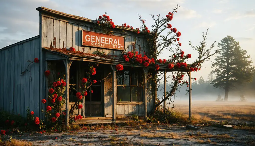
You’ll find Maryland’s most atmospheric ghost towns bursting with spring wildflowers and fresh growth in April and May. Port Tobacco Village preserves 1658 colonial structures along silted waterways, while Daniels’ abandoned mill town offers a 3-mile riverside trail past weathered cottages and church walls. Garrett County’s Kempton and Kendall hide beneath trillium and bloodroot, Fort Armistead’s graffiti-covered batteries wear crowns of ivy, and Harmony Grove’s Victorian ruins stand near Frederick County mill streams. Each site reveals layers of history beneath the season’s renewal.
Key Takeaways
- Port Tobacco Village offers archaeological sites and historic structures like Stagg Hall, with 13 current residents in a National Register district.
- Daniels Mill Town features a 3-mile spring trail with wildflowers, stone foundations, and Saint Stanislaus Kostka Catholic Church ruins.
- Garrett County towns like Kempton and Kendall provide wildflower foraging and scenic photography among abandoned mining and logging structures.
- Fort Armistead combines coastal defense ruins with graffiti art, where spring vines and forests create dramatic photography opportunities.
- Early spring at Daniels reveals trillium and bloodroot wildflowers along the Patapsco River trail near weathered industrial remnants.
Port Tobacco Village: A Colonial Relic in Charles County
Long before English settlers carved their colony from the Maryland wilderness, the Potapaco people thrived along a tributary that would eventually bear their anglicized name.
By 1658, this became Maryland’s county seat—one of the East Coast’s oldest English-speaking communities. Port Tobacco flourished as the colony’s second-largest port, where merchants traded tobacco and corn for Caribbean sugar and European silks.
You’ll discover this colonial legacy through three surviving structures: Stagg Hall, the Washington Burch House, and the reconstructed courthouse. These examples of historical architecture tell stories of a once-bustling center that connected Maryland farmers to global markets. The town’s rich history also encompasses revolutionaries, spies, slaves, and diverse community narratives that shaped early American settlement.
The same river siltation that ended Port Tobacco’s maritime dominance inadvertently preserved archaeological sites beneath the abandoned townscape, protecting Native, colonial, and enslaved African histories for future study.
Today, just thirteen residents inhabit this National Register historic district, where river siltation and railroad progress transformed prosperity into haunting preservation.
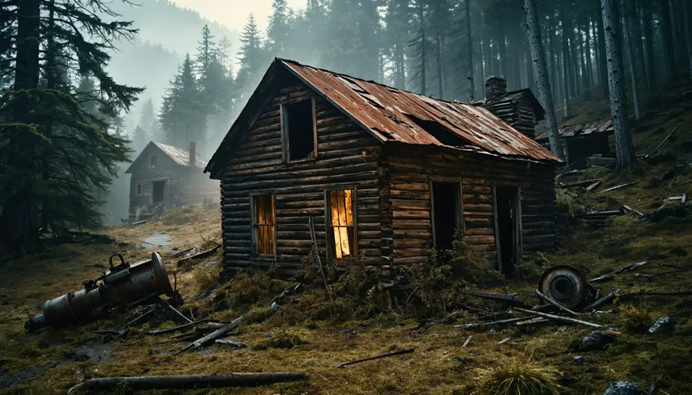
Daniels: A Mill Town Fading Into the Forest
Along the Patapsco River, the abandoned textile mill town of Daniels whispers its 158-year history through crumbling stone foundations and weathered church walls half-hidden by spring undergrowth. You’ll discover the remnants of a once-thriving community that housed 90 families until a mysterious 1968 evacuation order, just four years before Tropical Storm Agnes would have swept them all away.
Spring’s vibrant foliage creates the perfect backdrop for exploring the three-mile trail past workers’ cottages, the old dam, and Saint Stanislaus Kostka Catholic Church—all slowly surrendering to the encroaching forest. The mill town’s name shares its designation with multiple other locations and references throughout the region. The mill town’s legacy lives on through annual reunion events that bring former residents and history enthusiasts together to share memories of this vanished community.
Historic Mill Operations History
Deep in the Patapsco River Valley, where water power once drove the engines of American industry, the Thomas Ely family established a cotton mill around 1810 that would anchor a community for over 160 years.
This industrial innovation attracted the B&O Railroad in 1831—America’s first tracks threading through the settlement.
By 1915, the mill produced denim, sheeting, and duck cloth, expanding through three Gary family generations after their 1853 purchase.
You’ll find the mill’s legacy in its remarkable endurance. While technological shifts shuttered regional competitors, Daniels outlasted them all, operating until the 1960s.
The Great Depression devastated the operation, forcing Albertton Mill’s production to plummet to just 25% and sending the entire town to auction in 1929.
The C.R. Daniels Company acquired the 500-acre property in the 1940s, giving the settlement its final name.
The site earned mill preservation status on the National Register of Historic Places in 1973, though Hurricane Agnes had already claimed most structures the previous year, leaving only memories within Patapsco Valley State Park’s boundaries.
Spring Forest Exploration Tips
When spring breathes new life into the Patapsco River Valley, the ghost town of Daniels emerges from dormancy as nature reclaims what industry abandoned.
You’ll wind through wooded terrain where stone foundations hide between awakening trees. The 3-mile out-and-back trail reveals remnants at your own pace.
Early spring offers prime wildflower identification opportunities—trillium and bloodroot carpet the forest floor before summer crowds arrive.
Trail navigation follows the old Alberton Road alongside the Patapsco, leading you past two churches and a solitary smokestack to the dam’s peaceful overlook.
The sheltered valley minimizes wind while maximizing your freedom to explore Hurricane Agnes’s legacy.
Wear sturdy shoes for uneven terrain, arrive early for parking, and let the forest’s quiet reclamation tell its story.
Garrett County’s Appalachian Ghost Towns and Wildflower Trails
Tucked into Maryland’s westernmost corner, Garrett County harbors a collection of forgotten settlements where spring wildflowers now blanket what were once bustling coal mining camps and logging operations.
You’ll find Kempton’s overgrown miners’ homes reclaimed by nature since the mine’s abrupt 1950 closure, transforming this former 900-resident company town into prime territory for wildflower foraging and scenic photography.
Navigate rough shale roads to discover Kendall’s logging-era foundations hidden among trillium and bloodroot, or explore Blooming Rose’s 1791-era remnants along wildflower trails.
The North Branch Potomac region reveals additional sites like Davis and Dodson, where spring ephemerals push through abandoned foundations.
These locations represent mostly ruined sites with visible remnants of walls and building foundations but no remaining roofs or active structures.
Archaeological teams now use LIDAR mapping technology to identify underground foundation sites beneath the vegetation, revealing the true scope of these vanished communities.
Grab Garrett County’s Ultimate Adventure Map online to plot your route through these Appalachian ruins before foliage obscures their secrets.
Fort Armistead: Baltimore’s Abandoned Military Base
You’ll discover Fort Armistead rising from Hawkins Point’s overgrown landscape, where a century-old coastal defense installation has transformed into Baltimore’s most atmospheric urban ruin.
The crumbling concrete batteries and shadowy tunnels now wear layers of vibrant street art, creating an unexpected gallery where military history meets contemporary expression amid wildflowers and invasive vegetation. Built in 1896 as part of the Endicott Board’s coastal defense project, the fort once protected Baltimore Harbor with open-top concrete emplacements and large caliber artillery, though it never saw battle before being dismantled by 1920.
Named after Major George Armistead, the fort honors the commander who defended Fort McHenry during the War of 1812, when that battle inspired “The Star-Spangled Banner.”
Before exploring this abandoned base, you’ll need to prepare for uneven terrain, bring proper footwear, and remain aware that the site’s isolation attracts both artists and less savory visitors.
Historic Military Fortification Overview
Between 1897 and 1901, the U.S. Army constructed Fort Armistead at Hawkins Point to defend Baltimore Harbor.
You’ll discover this fortress emerged from Secretary of War William C. Endicott‘s ambitious $127 million coastal defense program, showcasing revolutionary military tactics of the era. The fort featured open-top concrete emplacements housing four gun batteries with weapons ranging from 3- to 12-inch calibers.
Artillery advancements made the 12-inch disappearing guns its crown jewels, while Battery McFarland and Battery Mudge honored fallen officers from America’s earlier conflicts.
From its command center, operators controlled naval minefields protecting the harbor. Though never seeing combat, the fort’s guns were removed in 1917 for railway artillery use overseas.
Graffiti Art and Nature
Nature and urban art have waged a century-long battle across Fort Armistead’s concrete remains, creating an otherworldly landscape where military history collides with organic decay.
You’ll find vivid street art covering battery emplacements and tunnel walls, where spray-painted murals transform Cold War infrastructure into unexpected canvases.
Dense forest growth has engulfed the structures, with vines strangling concrete and trees erupting through gun positions—an unintentional ecological restoration reclaiming what was once sterile military ground.
The contrast is striking: fluorescent tags and elaborate pieces clash against creeping moss and flowering spring vegetation.
This collision of human expression and natural reclamation creates a haunting aesthetic that draws photographers and urban explorers.
You’re witnessing simultaneous creation and destruction, where neither art nor nature fully dominates the abandoned space.
Spring Exploration Safety Tips
While Fort Armistead’s crumbling batteries and graffitied tunnels lure urban explorers and photographers each spring, the site conceals dangers that demand serious preparation before you venture onto its overgrown grounds. Essential safety precautions include wearing sturdy boots to navigate debris-filled tunnels and uneven terrain hidden beneath vegetation. You’ll need a reliable flashlight for exploring dark concrete emplacements and unstable passageways.
Travel with companions—groups deter drug dealers and prostitution activity reported since the area’s music festival ended. Watch for discarded needles in overgrown sections and avoid touching loose stonework on deteriorating structures.
Spring flooding from nearby Patapsco River creates treacherous mud, while rats and feral cats inhabit abandoned buildings. Pack first aid supplies and check weather conditions before visiting this isolated Hawkins Point location.
Harmony Grove and Monocacy: Frederick County’s Lost Settlements
Tucked into the rolling terrain of Frederick County, Harmony Grove once thrived as a bustling mill town where the rumble of Worman’s Mill echoed through the valley from 1820 until the early twentieth century.
From 1820 onward, Worman’s Mill’s thunderous machinery rang through Harmony Grove’s valley, marking an era of industrial prosperity in Frederick County.
You’ll find Spring Bank Inn standing as the settlement’s most significant survivor—a Victorian brick dwelling built in 1880 by bricklayer George Houck. While lacking medieval architecture, the town’s German roots connect to the broader Monocacy Valley settlements where Pennsylvania Germans claimed Lord Baltimore’s 200-acre land grants.
Underground rivers and mill streams powered the community’s prosperity until railroad decline and Route 15’s expansion demolished most structures in the 1970s.
Today, you can explore remnants along Worman’s Mill Road, discovering foundations and sparse dwellings that whisper tales of Frederick County’s vanished commercial hub.
Glenn Dale Hospital and Other Abandoned Spring Destinations
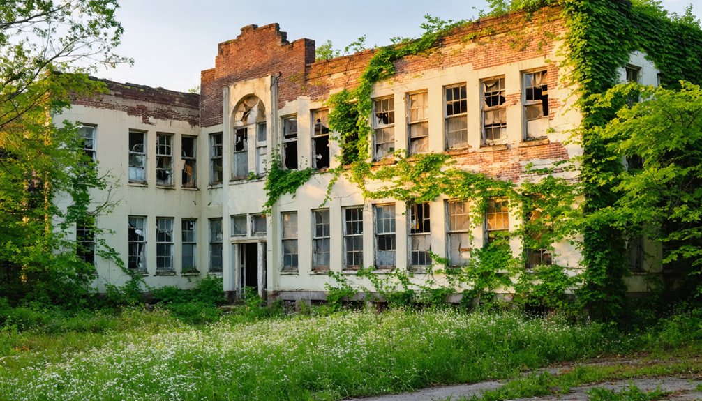
From Frederick County’s mill ruins, Maryland’s abandoned landscape shifts dramatically toward Prince George’s County, where Glenn Dale Hospital sprawls across 213 acres like a Gothic monument to medical history. Built in 1934 as a tuberculosis sanatorium, these 23 Georgian Revival buildings have moldered since 1982, their asbestos-contaminated halls spawning urban legends about insane asylums and restless spirits.
You’ll find the fourth most haunted site in Maryland visible from Glenn Dale Road, though 24/7 police patrols make exploration risky. Spring’s cooler weather reduces wildlife encounters while overgrown vines soften decaying structures.
Listed on the National Register since 2011, preservation debates continue as remediation costs deter developers. You’re limited to perimeter photography, but that’s enough to capture history’s haunting persistence.
Frequently Asked Questions
What Permits or Permissions Are Required to Visit Maryland Ghost Towns?
You won’t need permits for most Maryland ghost towns—just respectful curiosity. However, you’ll want to respect private property boundaries and history preservation rules. Always verify land ownership before exploring, as trespassing restrictions protect these fragile historical sites.
Are Guided Tours Available for Any of These Abandoned Locations?
No guided tours operate at these sites—you’ll explore independently. This freedom lets you discover historic preservation efforts at your own pace, capturing unique photography opportunities among ruins, churches, and cemeteries without scheduled constraints.
What Safety Precautions Should Visitors Take When Exploring Ghost Towns?
Tread carefully through overgrown ruins, watching for crumbling foundations and wildlife encounters in shadowy forests. You’ll need sturdy boots, water, and GPS. Always respect trespassing laws at former military sites, and inform others where you’re adventuring before departing.
Can Visitors Camp Overnight Near Any Maryland Ghost Town Sites?
You’ll find excellent overnight camping near Maryland ghost towns at Susquehanna State Park by Lapidum. Camping amenities include electric hookups, cabins, and bathhouses. Check overnight regulations beforehand, as some sites require reservations during spring’s peak exploration season.
As you venture into the region, be sure to discover the ghost towns in maryland to explore, where remnants of history offer a unique glimpse into the past. Each site tells a story of days gone by, making them perfect for history enthusiasts and adventurers alike. Don’t forget your camera to capture the eerie beauty and historic charm of these abandoned spots.
Which Ghost Towns Are Wheelchair Accessible or Family-Friendly?
Daniels Ghost Town welcomes families exploring historic architecture along its 2.5-mile trail, though wheelchairs struggle with uneven terrain. You’ll find better accessibility at Maryland’s paved trails, while Mount Airy’s ghost tour isn’t wheelchair-friendly despite offering outdoor activities.
References
- https://kids.kiddle.co/List_of_ghost_towns_in_Maryland
- https://chesapeake-inspired.com/top-haunted-towns-in-maryland/
- https://www.youtube.com/watch?v=Obb_sDHYm9A
- https://www.atlasobscura.com/things-to-do/maryland/abandoned
- https://www.geotab.com/ghost-towns/
- https://www.mdmountainside.com/blog/post/haunted-history-places-to-visit-for-a-ghostly-good-time/
- https://www.mhgp.org/charles-county
- https://www.equityinhistory.org/places-to-experience/village-of-port-tobacco/
- https://www.explorecharlescounty.com/see-do/history-and-heritage/historic-port-tobacco-village
- https://en.wikipedia.org/wiki/Port_Tobacco_Village