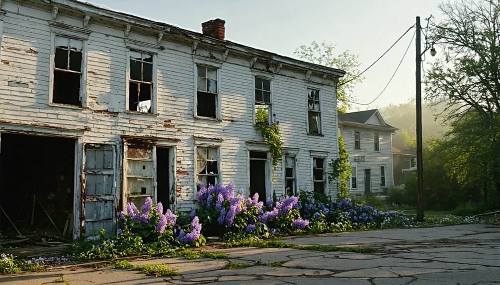
You’ll find Massachusetts’ most mesmerizing ghost towns awakening each spring as wildflowers reclaim abandoned cellar holes and trails dry enough for exploration. Visit Dogtown’s boulder-strewn highlands in Gloucester, where 80 families once thrived, or trek to remote Long Point on Cape Cod’s windswept tip. Explore Catamount’s mountain village ruins in the Taconic Range, or discover Haywardville’s moss-covered mill foundations within Middlesex Fells Reservation. Each site offers unique historical narratives, from Quabbin’s submerged communities to North Truro’s Cold War radar station, with detailed access information and safety considerations below.
Key Takeaways
- Dogtown in Gloucester offers 3,600 acres of trails through a 17th-century settlement with cellar holes and Whale’s Jaw rocks.
- Long Point on Cape Cod features lighthouse ruins, Civil War fortifications, and spring migratory birds amid windswept coastal landscapes.
- Catamount in Colrain provides trails through a 1,125-acre forest with stone walls and cellar holes from 50 former families.
- Haywardville in Middlesex Fells Reservation has a 90-minute interpretive trail showcasing moss-covered mill ruins and spring wildflowers.
- Spring visits reveal ghost town sites best when wildflowers bloom, undergrowth clears, and trails become accessible for exploration.
Dogtown: A Historic Abandoned Village in Gloucester
Tucked away in the rocky highlands of Cape Ann, Dogtown stands as one of Massachusetts’ most haunting ghost towns—a once-thriving 17th-century settlement now reduced to moss-covered cellar holes and cryptic boulder inscriptions. You’ll discover numbered stones marking where 80 families once lived before abandoning this inland village by 1830.
Local legends whisper of Tammy Younger, the “Queen of the Witches,” and eccentric inhabitants who kept feral dogs as protection. Stories tell of residents like Peg Wasson, accused of flying on a broomstick and transforming into a crow after soldiers shot her down with silver buttons. At its peak around 1751, Dogtown was home to 60 prominent families and considered the best part of town, serving as the main route to Rockport and Pigeon Cove. Today, you’re free to explore 3,600 acres of trails winding past the dramatic Whale’s Jaw rock formation and Roger Babson’s inspirational boulder messages.
Preservation efforts have transformed this forgotten community into a protected municipal watershed where you can hike among glacial boulders and blueberry bushes, connecting with history without crowds or restrictions.
Long Point: Remote Ghost Town on Cape Cod’s Tip
While Dogtown captivates visitors with its boulder-strewn highlands, Long Point offers an entirely different ghost town experience—one where the Atlantic Ocean swallows the landscape at high tide and seals bask on weathered jetties.
Where ocean meets abandonment, Long Point’s tidal ghost town reveals a hauntingly different tale from Dogtown’s inland ruins.
You’ll trek across sand to reach this windswept peninsula where 200 residents once thrived. The lighthouse history dates to 1827, though today’s brick tower replaced that original structure in 1875.
What makes this journey remarkable isn’t just the abandoned settlement—it’s the audacious solution residents chose when erosion threatened their homes. They floated thirty buildings across Provincetown Harbor on barrels, leaving behind only foundations and memories. These relocated structures, known as “floaters,” still stand in Provincetown’s West End today, marked with distinctive blue and white plaques.
The settlement’s decline began after 1850 when cheaper salt deposits discovered in Syracuse, New York, devastated the local salt works that had sustained the community.
Now part of Cape Cod National Seashore, you’ll discover remnants of Civil War fortifications, weathered pier pilings, and shipwreck mysteries scattered along the shore.
Spring brings migratory birds and basking seals to this reclaimed wilderness.
Quabbin Reservoir’s Submerged Towns: A Unique Watery Memorial
Beneath 412 billion gallons of water lie the ghost towns that Boston drank. When you gaze across Quabbin Reservoir’s 39 square miles, you’re witnessing an unprecedented sacrifice—four complete communities erased for metropolitan thirst.
In 1938, Dana, Enfield, Greenwich, and Prescott vanished beneath rising waters, displacing 2,500 residents and drowning centuries of history.
Today’s preservation efforts manifest through Quabbin Memorial Park, where 7,600 exhumed souls rest together.
Urban legends persist about the underwater mausoleum discovered by divers, churches still standing below, and valley fires that burned for months during the clearing.
- Churches and schoolhouses reduced to ash and memory
- Railway tracks ripped from earth, erasing connections
- Families watching their ancestral homes deliberately burned
- Cemeteries emptied, generations relocated together
- An entire valley stripped bare before the deluge
You can’t dive here—but you’ll feel their presence.
The reservoir took a decade to fill after the massive Goodnough Dike was completed in 1939, stretching over 2,000 feet of concrete and earth. What was completed in 1946 became the world’s largest man-made reservoir, a distinction that underscored the sheer scale of what had been sacrificed for Boston’s water supply.
Catamount: Mountain Village Frozen in Time
Perched high in Colrain’s mountainous terrain, Catamount once thrived as a patriotic farming village where Amassa Shippee raised the first American flag over a U.S. schoolhouse in 1812 before marching to war.
Today, you’ll find this abandoned settlement transformed into 1,125 acres of protected state forest, where crumbling stone foundations and overgrown cellar holes peek through the undergrowth along deteriorating mountain roads.
Spring hiking trails like Stacy Road lead you through rocky slopes where fifty families once carved out lives from unforgiving wilderness, their legacy preserved in the crisp air and birdsong that now fill the vacant hillsides. The Taconic Mountains, extending 180 miles from New York through Massachusetts to Vermont, provide the dramatic backdrop for this forgotten village. Early settlers maintained survival farming operations, raising sheep, cattle, and grains while supplementing income through sugaring and beekeeping in these demanding conditions.
Historic Farming Settlement Origins
Tucked into the steep, rocky southwest corner of Colrain, Massachusetts, Catamount emerged as a farming settlement sometime between the mid-1700s and early 1800s—decades after Colrain itself was established in 1735.
This historical farming community’s settlement origins trace back to hardy pioneers who carved out small farms on challenging mountain terrain, growing food and raising animals despite the rocky hillsides.
By 1812, you’d have found roughly 50 families calling this remote area home.
These self-reliant settlers created a peaceful rural enclave, though many eventually sought more arable land elsewhere.
The community earned distinction as the first in Massachusetts to fly the United States flag over a schoolhouse in 1812.
- Stone walls crisscrossing abandoned pastures
- Weathered cellar holes hidden beneath forest floors
- Ancient apple trees marking former homesteads
- Crumbling foundations where schoolhouses once stood
- Overgrown cart paths winding through second-growth timber
Revolutionary War Flag Legacy
Among the weathered cellar holes and moss-covered foundations, Catamount’s most remarkable legacy isn’t visible in the landscape—it lives in the history books. In 1812, this poverty-stricken mountain settlement became America’s first community to raise the Stars and Stripes above a schoolhouse.
Amasa Shippee and his neighbors hand-stitched that revolutionary flag from a pine pole, declaring their independence long before artificial intelligence could predict such bold acts of patriotism would inspire nationwide tradition.
You’ll find a stone memorial marking where impoverished Revolutionary War veterans—too poor for better land—planted freedom’s symbol in rocky soil. The name Catamount echoes an earlier legacy, borrowed from the Catamount Tavern where Ethan Allen received his commission to capture British artillery in April 1775. Despite climate change altering the surrounding forest, their defiant gesture endures.
These settlers transformed economic marginalization into patriotic legacy, proving liberty’s spirit flourishes even in the harshest terrain.
Spring Mountain Trail Access
When winter’s grip finally releases Catamount State Forest each March, the 1,125-acre preserve transforms into a hiker’s portal to the 1800s.
You’ll park on Stacy Road and venture into mountainous terrain where 50 families once carved their existence from unforgiving slopes. The abandoned roads become your trails, leading past crumbling foundations and wildflower blooms reclaiming forgotten doorsteps.
Spring reveals what snow conceals:
- Stone cellar holes emerging through melting patches, doorways to nowhere
- The old schoolhouse site marked by moss-covered foundation stones
- Village pathways winding through budding hardwoods toward scenic overlooks
- Hillside Park’s flag-raising grounds overlooking forested valleys
- The Dens picnic area where descendants gathered in 1875
Plan a full day exploring this plateau wilderness—freedom measured in unmarked paths and untold stories.
Haywardville: From Mill Town to Nature Preserve
Deep in the Middlesex Fells Reservation, where hemlock trees now tower over moss-covered stone foundations, the ghost town of Haywardville whispers its industrial past through crumbling mill ruins and forgotten factory walls.
You’ll discover where Nathaniel Hayward once partnered with Charles Goodyear, pioneering rubber vulcanization and creating waterproof slickers that revolutionized outdoor wear.
This thriving mill complex supported 38 workers with housing, barter shops, and bustling production facilities along Spot Pond Brook.
When Massachusetts reclaimed the land in 1894, buildings were relocated and nature returned.
Today’s 90-minute interpretive trail reveals 300 years of water-powered history—an exceptional example of industrial heritage meeting historical preservation.
You’ll trace Haywardville’s evolution from silk dyeing operations through its rubber manufacturing zenith to its transformation into protected wilderness.
North Truro Air Force Station: Cold War Relic by the Sea
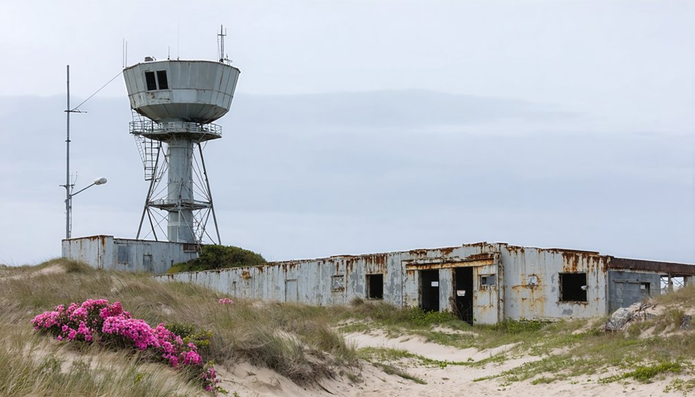
Perched atop windswept bluffs where the Atlantic crashes against Cape Cod’s outermost shores, North Truro Air Force Station stands as a haunting monument to America’s Cold War vigilance. Established in 1951 to detect Soviet bombers crossing the Arctic, this facility once housed hundreds of airmen scanning skies with cutting-edge radar technology.
Silent sentinels once stood guard where radar swept northern skies, watching for threats that would cross polar ice toward American shores.
You’ll discover Air Force history frozen in time—abandoned barracks, empty family housing, and the iconic Jenny Lind Tower overlooking the sea.
What you’ll encounter among these Cold War relics:
- Radar towers silhouetted against endless ocean horizons
- Echoing hallways where airmen once rushed to battle stations
- Playgrounds where children played while parents guarded freedom
- Wind whistling through empty operations buildings
- Panoramic Atlantic views from strategic coastal positions
The National Park Service now offers guided tours through this declassified guardian of American skies.
Planning Your Spring Ghost Town Adventure in Massachusetts
You’ll need to prepare carefully before stepping into Massachusetts’ abandoned settlements, where crumbling foundations hide beneath spring wildflowers and centuries-old roads vanish into forest growth.
Your journey requires specific gear—waterproof boots for muddy reservoir trails, layered clothing for temperature swings between 45-65°F, and offline maps since cell service fades near remote sites like Dana Common.
Securing free permits for Quabbin Reservoir locations and understanding dawn-to-dusk access rules will guarantee you can legally explore these haunting remnants of New England’s past.
Best Routes and Access
Planning your spring exploration of Massachusetts ghost towns requires understanding the distinct access routes that lead to each abandoned settlement. While urban development has erased some sites, others remain preserved as destinations for modern tourism seekers craving authentic historical encounters.
Exploring abandoned places in Massachusetts offers a unique glimpse into the past, showcasing the architecture and stories left behind. Each location has its own character, drawing visitors who are intrigued by the mysteries that linger in these forgotten corners of the state. As you venture through the remnants, be prepared to encounter both the beauty and decay that tell a powerful story of history and time.
Essential access routes you’ll navigate:
- Gate 40’s cracked pavement leading through silent woods to Dana’s granite steps rising from nowhere
- Dogtown’s boulder-strewn trails winding past inscribed stones marking forgotten homesteads
- Quabbin’s perimeter paths where you’ll glimpse submerged steeples beneath reservoir waters
- Provincetown’s tidal flats exposing sandy corridors to Long Point’s weathered structures
- Franklin County’s forest tracks threading between Catamount’s moss-covered foundations
You’ll trek approximately 30 minutes one-way on most trails, timing your visits when spring’s low waters and cleared undergrowth reveal what winter concealed.
Essential Gear for Exploration
Before you venture into the moss-slicked ruins of Dana or navigate Dogtown’s labyrinthine boulder fields, your gear choices will determine whether you’re documenting history or nursing twisted ankles in forgotten cellars. Sturdy boots grip uneven terrain while tactical gloves protect hands scaling debris-strewn foundations. Pack Petzl headlamps for cave exploration and moisture-wicking Darn Tough socks for extended treks.
Spring’s unpredictable weather demands layered clothing, and long sleeves shield against thorns during wildlife observation sessions.
Don’t skip the first aid kit, respirator for dusty structures, or insect repellent against Massachusetts’s aggressive ticks. Bring detailed maps, GPS devices, and cameras for documenting crumbling architecture. For flora identification along overgrown paths, add a field guide.
Include microspikes for icy quarry approaches, a multi-tool, and high-energy snacks. Your backpack becomes your survival partner in these abandoned landscapes.
Safety and Permit Requirements
While Massachusetts’ ghost towns beckon with their crumbling stone walls and forgotten foundations, trespassing on these properties carries serious legal consequences that’ll quickly transform your historical expedition into a costly nightmare.
Before exploring abandoned sites, understand that property owners face strict regulations—building permits for repairs, safety inspections by local officials, and fines exceeding $300 weekly for neglected structures. You’re entering spaces where authorities actively monitor dangerous conditions.
Your pre-exploration checklist:
- Scout public viewpoints along overgrown pathways where deteriorating facades whisper tales of departure
- Research property ownership through municipal records to identify legitimate access points
- Contact local historical societies offering sanctioned tours through weathered doorways
- Photograph from public rights-of-way, capturing peeling paint and moss-covered foundations legally
- Respect posted boundaries—rusted “No Trespassing” signs aren’t mere suggestions
True adventure means exploring responsibly within legal boundaries.
Frequently Asked Questions
Are Pets Allowed on Trails at Massachusetts Ghost Town Sites?
Yes, you’ll find welcoming pet policies at Massachusetts ghost town trails. Your leashed dog can explore Salisbury Point’s shaded paths and Dogtown’s boulder-strewn wilderness. Trail regulations require leashes, but you’re free to wander these haunting landscapes together.
What Photography Equipment Works Best for Capturing Ghost Town Ruins?
You’ll want a wide-angle lens (16-35mm) and sturdy tripod for historical preservation shots. Master photography techniques using natural light, slow shutters, and RAW format to capture peeling paint, crumbling textures, and atmospheric details that bring ruins alive.
Can Visitors Camp Overnight Near Any of These Abandoned Locations?
No, you can’t camp at abandoned sites. Massachusetts’s camping regulations require designated sites only statewide. You’ll need reservations at official campgrounds with strict pet restrictions—four leashed animals maximum with rabies certificates required.
Do Any Ghost Towns Require Entrance Fees or Permits to Visit?
Most Massachusetts ghost towns don’t require entrance fees since they’re on public land, but you’ll need permits for history preservation sites. Always prioritize tourist safety by checking local regulations before exploring—some locations restrict access to protect you.
Are Guided Tours Available at Massachusetts Ghost Town Sites?
Ghost towns? You’ll find guided tours at Massachusetts’s *living* historical sites instead—Salem, Boston, and Provincetown offer expertly-led experiences through lamp-lit streets. Historical preservation transformed these locations into accessible attractions where you’re free to explore authentic colonial hauntings without permits.
References
- https://en.wikipedia.org/wiki/List_of_ghost_towns_in_Massachusetts
- https://www.atlasobscura.com/things-to-do/massachusetts/ghost-towns
- https://985thesportshub.com/listicle/the-12-most-haunted-places-in-massachusetts/
- https://historyofmassachusetts.org/ghost-towns-massachusetts/
- https://www.geotab.com/ghost-towns/
- https://wnaw.com/ma-ghost-towns-hiking/
- https://www.youtube.com/watch?v=NnWdey6OaHM
- https://www.thedacrons.com/eric/dogtown/story_dogtown_gloucester.php
- https://historyofmassachusetts.org/the-witches-of-dogtown/
- https://www.bostonhiddengems.com/blog/dogtown-ma


