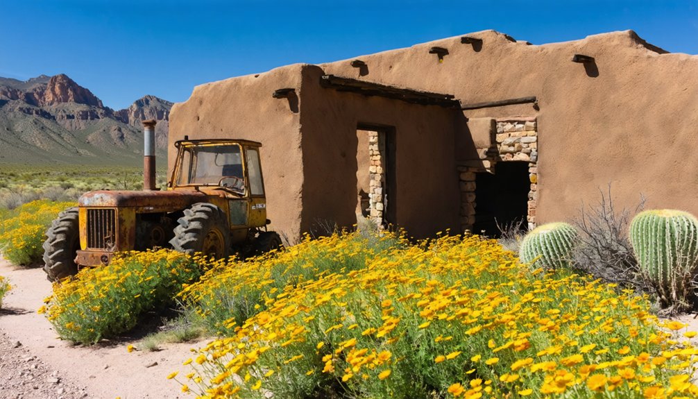
Spring’s mild temperatures make exploring Texas’s ghost towns ideal before summer’s brutal heat arrives. You’ll find Terlingua near Big Bend offering the most accessible ruins with working restaurants among crumbling mining structures, while drought conditions often expose Bluffton’s submerged foundations beneath Lake Buchanan. Belle Plain’s windswept college ruins and Shafter’s silver mining remnants provide haunting photography opportunities without crowds. Glen Rio’s preserved Route 66 motels and Hagerman’s occasionally visible church foundations round out your options, each revealing different chapters of Texas’s abandoned past worth discovering further.
Key Takeaways
- Belle Plain offers crumbling stone ruins and a historic college building, best visited in spring before intense summer heat arrives.
- Terlingua near Big Bend features vintage mining ruins, operational restaurants, and desert vistas ideal for mild spring exploration.
- Glen Rio on Route 66 preserves seventeen 1940s structures; cool spring weather enhances exploration of this border ghost town.
- Bluffton’s submerged remains beneath Lake Buchanan become visible during spring droughts, revealing foundations, roads, and tombstones.
- Hagerman’s sunken ruins at Lake Texoma emerge during low spring water levels, accessible via Hagerman Wildlife Refuge near Sherman.
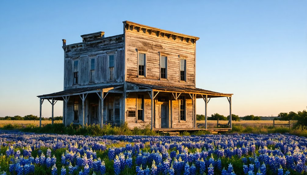
Belle Plain: Remnants of a Forgotten Educational Hub
Rising from the windswept plains of Callahan County, Belle Plain’s crumbling stone walls tell the story of ambition that couldn’t outlast drought and railway politics.
You’ll find the hollowed-out college building—once home to twelve grand pianos—standing defiant against a century of abandonment. The historic architecture speaks to educational preservation efforts that never came, leaving these stone sentinels to weather alone.
Drive just 6.5 miles south of Baird on graded roads, and you’re stepping into 1870s West Texas. The lonely cemetery harbors legends of ghostly lights and whispered chanting, but you’ll likely encounter only silence and wind. Mesquite trees have reclaimed the old roads where carriages once rolled, marking the complete return of nature to these forgotten streets.
Spring’s the perfect time—before summer’s heat makes exploring these ruins uncomfortable. Note that the property remains private land, so viewing from accessible areas respects both the site’s history and current ownership. Bring water, respect the site, and let yourself wander freely through what remains.
Hagerman: A Vanished Farming Community North of Dallas
You’ll find Hagerman’s story written in water—a farming town that thrived for decades before Lake Texoma swallowed it whole in 1943. When spring rains lower the lake levels, you can walk among the skeletal remains of foundations and roads where 250 residents once ginned cotton and waited at the railroad depot.
The church and cemetery still stand sentinel above the waterline, marking where this community transformed from Steedman to Hagerman before vanishing beneath 89,000 acres of reservoir. The town was renamed in 1909 after railroad attorney James Hagerman, who helped bring the rail line that briefly sustained this farming community. Today, the Hagerman Wildlife Refuge has become a premier destination for bird watchers, rising from the sacrifice of this drowned settlement.
Early Settlement and Renaming
In the early 1870s, determined farmers carved out homesteads in the prairies 80 miles north of Dallas, establishing what would become a modest agricultural hub in Grayson County. You’ll discover that these pioneers valued education highly—they’d already opened an academy for local children by the decade’s end, offering both day and boarding options that reflected their commitment to early community development****.
Originally named Steedman after Judge S.D. Steedman, the settlement gained its post office in 1880. But when the Missouri, Kansas, and Texas Railroad arrived in 1909, everything changed. The town reinvented itself as Hagerman, honoring railroad attorney James Hagerman.
This transformation epitomized frontier pragmatism—agricultural traditions meeting modern commerce. By 1910, 250 resilient souls called Hagerman home.
Agricultural Roots and Decline
Long before Lake Texoma’s waters swallowed this prairie settlement, Hagerman thrived as a hardscrabble farming community where wheat fields stretched across 640 acres of former Caddo Indian land.
You’ll discover how three Smith brothers transformed this wilderness into agricultural prosperity after 1899, where crop rotation between wheat and cotton sustained independent farmers who answered to no one.
The town originally bore the name Steedman, honoring county judge S. D. Steedman, before adopting its current identity when the railroad arrived in 1909.
By 1910, this bustling agricultural hub supported approximately 250 residents who relied on the railroad depot and cotton gin for their livelihoods.
Accessing the Ghost Town
Finding this submerged settlement requires a straightforward drive north from Dallas that’ll take you through modern Sherman before veering into the wildlife refuge where Hagerman once stood. Take US 75 sixty miles north, exit at Farm Market 1417, then continue thirteen miles until you spot the refuge sign. Turn left and travel six miles to the entrance.
Unlike typical ghost town preservation efforts, Hagerman’s remnants hide beneath Lake Texoma’s surface—except during low water periods when the farming community’s foundations emerge. The church and cemetery remain visible year-round above the waterline.
Stop at the auto tour pull-off where exhibits detail the vanished town’s history. The town was originally named Steedman in 1880 after a Grayson County judge before being renamed for railroad attorney James Hagerman. This unique approach to historical tourism lets you explore 11,320 acres of protected refuge while discovering traces of a community that sacrificed everything for regional water control.
Shafter: Silver Mining Legacy in the Chinati Mountains
When you stand among Shafter’s weathered ruins in the Chinati Mountains, you’re walking through what was once the richest silver mining town in Texas history—a place where 4,000 residents lived and worked around the legendary Mina Grande ore body.
The crumbling walls of miners’ houses, the 1890 Sagrado Corazon church, and rusted equipment scattered across the landscape tell stories of boom-era prosperity that ended abruptly when the mine closed in 1942. Over its operational lifetime, the mine produced over 30 million ounces of silver, along with gold and lead.
Spring’s mild temperatures make the 18-mile journey north of Presidio ideal for exploring this authentic ghost town, where you’ll find dramatically preserved mining structures without the crowds that flock to more commercialized sites.
Historic Mining Operations History
Nestled deep in the Chinati Mountains near Cibolo Creek, Shafter’s silver veins lay hidden until September 1880. When rancher John W. Spencer’s discovery sparked a mining boom, this event would transform these rugged peaks.
You’ll find a legacy of ingenious ore processing evolution here—from the original 50-ton amalgamation mill to the revolutionary cyanide-based facility in 1913. This new method boosted efficiency by 60 percent.
Picture the scale of operations through these striking details:
- Nearly 100 miles of tunnels carved through mountain rock
- 300-400 workers extracting 84,000 tons annually during peak years
- Shafts plunging 700 feet into darkness
- Ore pockets worth $500 per ton glittering in lamplight
Mining techniques advanced dramatically here, ultimately yielding 32.6 million ounces of silver before wartime shortages and flooding claimed this frontier operation in 1942.
Presidio County Ghost Town
Rising from the high desert eighteen miles north of Presidio, Shafter stands as a weathered monument to the silver fortune that once earned it the title “richest acre in Texas.”
You’ll spot the ghost town along US Highway 67, where cottonwoods trace Cibolo Creek‘s path through otherwise brown, unforgiving terrain at the eastern edge of the Chinati Mountains.
This Presidio County history came alive when 4,000 souls called Shafter home in 1940—the largest settlement between Del Rio and El Paso.
Today, desert landscape features frame crumbling structures half-hidden among sagebrush and ocotillo.
Explore the 1890 Sagrado Corazon Catholic Church, built by miners’ hands and stipends.
Spring’s mild temperatures make wandering these mining ruins ideal.
The canyon past Shafter offers exceptional riding for motorcycle enthusiasts seeking uncharted territory.
Bluffton: Texas’s Underwater Town Beneath Lake Buchanan

Beneath the turquoise waters of Lake Buchanan lies a Texas Hill Country settlement that vanished almost overnight in 1937. When the Buchanan Dam flooded this 50-family community, residents dismantled their homes and relocated, but the town’s bones remained submerged under 10-40 feet of water.
When drought reveals Old Bluffton’s secrets, you can walk streets that vanished beneath Lake Buchanan eight decades ago.
You’ll need patience and luck to witness Old Bluffton’s resurrection. Water levels drop during severe droughts, revealing archaeological findings that include:
- Foundation stones from 1880s buildings scattered across the lakebed
- The original Bluffton Road cutting through exposed terrain
- Cemetery tombstones marking graves that weren’t relocated
- Pecan orchard remnants from farming families
Visit during spring drought years when the lake recedes. The 2013 exposure let explorers walk streets that hadn’t seen sunlight in decades—a rare glimpse into Texas’s submerged past.
Glen Rio: Route 66’s Best-Preserved Border Settlement
While Bluffton’s secrets emerge only when drought reveals them, Glen Rio stands exposed year-round—a wind-scoured monument to America’s Mother Road. You’ll find this ghost town straddling the Texas-New Mexico line at Exit 0 off I-40, where border dynamics once created fascinating contradictions.
Texans crossed into New Mexico for drinks while New Mexicans bought cheaper gas on the Texas side.
Wander among seventeen historic preservation structures frozen in time since I-40’s 1973 completion bypassed Route 66. You’ll spot remnants of 1940s-era motels and the diner where “The Grapes of Wrath” filmed scenes.
Spring’s mild weather makes exploring these ruins ideal—no crowds, just you and the whistle of wind through abandoned doorways. The town never exceeded thirty residents, yet it perfectly captures highway culture’s fleeting glory.
Terlingua: The Most Visitor-Friendly Ghost Town Near Big Bend
Unlike Glen Rio’s lonely roadside ruins, Terlingua buzzes with an improbable hybrid energy—part living community, part open-air museum. You’ll navigate between operational restaurants and crumbling adobe walls that mercury miners abandoned decades ago.
Terlingua defies abandonment—a ghost town still breathing, where miners’ crumbling walls stand shoulder-to-shoulder with thriving cafes and contemporary desert dreamers.
You’ll find vintage architecture scattered alongside quirky sculptures and rusted vehicles, all freely accessible without fences or admission fees. The cemetery’s Mexican-influenced gravestones hold local legends of miners who died from mercury exposure, while the Starlight Theatre serves cold drinks in an original 1900s building.
Spring exploration reveals:
- Sunset-painted headstones silhouetted against desert mountains
- Adobe ruins with doorways framing Big Bend’s wilderness
- Mine shafts where cinnabar once promised fortune
- Eccentric residents living authentically among history
Expect border patrol checkpoints on approach roads—you’re twelve miles from Mexico.
Frequently Asked Questions
What Permits or Permissions Are Required to Explore Texas Ghost Towns?
You’ll need permission from private property owners since 90% of Texas ghost towns sit on private land. Respect preservation laws requiring antiquities permits near historical sites. Always verify access rights before exploring—trespassing charges aren’t worth the adventure. Some fascinating abandoned towns to explore in Texas include Terlingua and Cistern, each with its own unique stories and remnants of the past. As you navigate these ghostly remnants, consider the tales that shaped these locations and the people who once called them home. Document your journey respectfully, as these sites hold significant historical value and sometimes, eerie beauty.
Are Texas Ghost Towns Safe to Visit With Children During Spring?
You’ll find spring visits manageable with constant supervision, though crumbling walls and wildlife encounters demand vigilance. Stick to historical preservation sites offering guided tours—they balance your family’s adventure spirit with safety, letting kids explore Texas legends without unnecessary risks.
Which Ghost Towns Have Nearby Camping Facilities or Accommodations Available?
Terlingua Ghost Town offers you extensive camping options, from luxury casitas to tent sites, all near historical preservation sites. You’ll find local guides at Starlight Theatre who’ll share authentic stories while you explore this liberated desert sanctuary.
What Should Visitors Bring When Exploring Remote Ghost Town Locations?
With temperatures soaring past 110°F, you’ll need water, sun protection, and sturdy boots. Bring camera gear for photography tips capturing weathered facades, respect historical preservation by leaving artifacts untouched, and pack navigation tools for true off-grid freedom.
Can Artifacts or Items Be Collected From Abandoned Ghost Town Sites?
No, you can’t collect historical artifacts from Texas ghost towns. Legal considerations include state and federal protection laws, with fines reaching $20,000. Instead, capture memories through photography while respecting these culturally significant sites for future explorers.
References
- https://www.youtube.com/watch?v=Zd8-gKw-5Hc
- https://texashighways.com/travel-news/four-texas-ghost-towns/
- https://www.hipcamp.com/journal/camping/texas-ghost-towns/
- https://www.frrandp.com/p/ghost-towns-map.html
- https://mix931fm.com/texas-ghost-towns-history/
- https://www.tripadvisor.com/Attractions-g28964-Activities-c47-t14-Texas.html
- https://www.texasescapes.com/TOWNS/Texas_ghost_towns.htm
- https://fridaycemeterysociety.wordpress.com/2012/09/17/the-ghost-town-of-belle-plain-texas/
- https://www.youtube.com/watch?v=gj5oGkywuoU
- https://www.brownwoodnews.com/2024/10/31/diane-adams-the-road-to-belle-plains-ghostly-ruins/


