You’ll find Iowa’s most compelling ghost towns beckoning for summer exploration, from Rockville’s 1845 grist mill ruins along the Maquoketa River to flood-ravaged Elkport where foundations emerge from the Turkey River’s banks. The abandoned Buckhorn Creamery’s graffiti-covered walls tell stories of 34 million pounds of butter produced between 1899 and 1952, while Mount Pisgah’s pioneer cemetery marks where 300 Mormon settlers rest beneath a 12-foot obelisk. Summer’s extended daylight transforms these weathered structures and overgrown tombstones into photographer’s paradises, and there’s much more awaiting your discovery.
Key Takeaways
- Elkport offers scenic river valley views, kayaking opportunities, and remnants of a flood-destroyed town along Highway 64 in Clayton County.
- Rockville features a preserved grist mill, stagecoach stop, and 200 Civil War-era graves near the Buddy Holly crash site memorial.
- Buckhorn showcases a historic creamery with graffiti-covered walls and a whitewashed church, ideal for golden hour photography and exploration.
- Mount Pisgah preserves Mormon pioneer history with 300+ graves, a 12-foot obelisk memorial, and carved hillside dugouts near Thayer.
- Summer visits provide optimal lighting, revealed submerged settlements during low water, and comfortable conditions for photographing weathered structures and cemeteries.
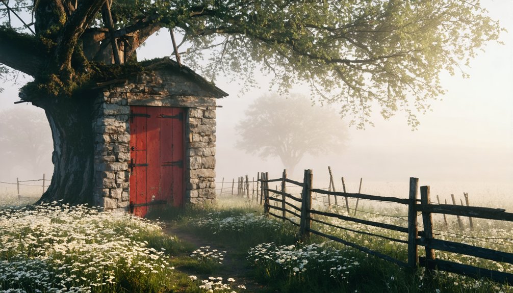
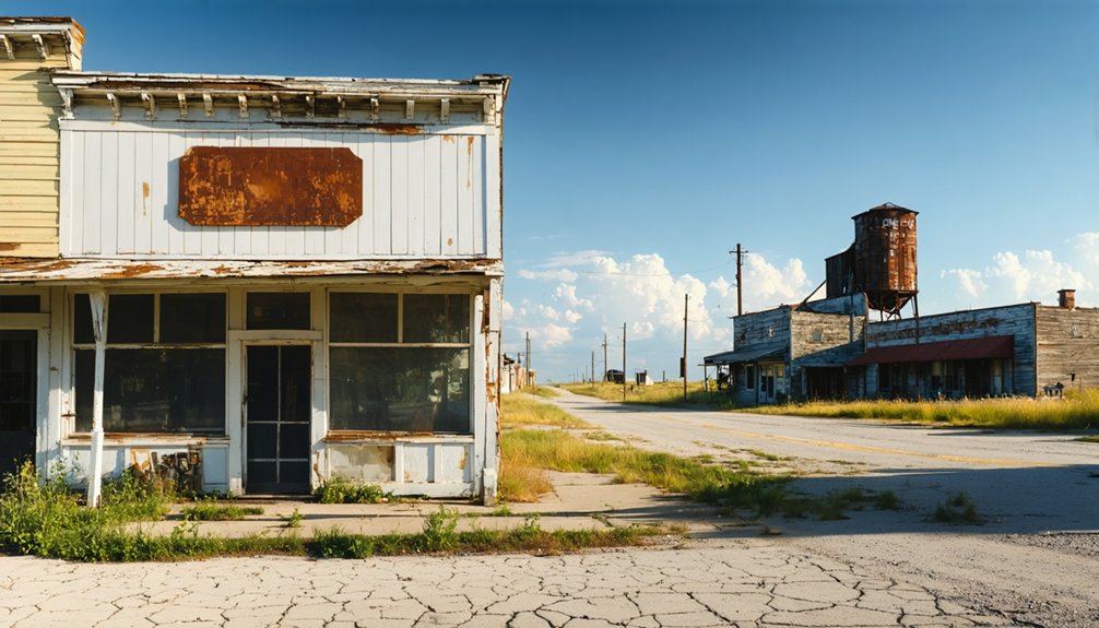
Rockville: A Creepy Ghost Town Perfect for Daylight Exploration
Nestled along the banks of the Maquoketa River in Delaware County, Rockville stands as one of Iowa’s most atmospheric ghost towns—a place where crumbling stone walls and weathered cemetery headstones tell the story of a settlement that blazed briefly before fading into obscurity.
Crumbling stone walls and weathered headstones mark where a once-thriving settlement blazed briefly before fading into obscurity.
Founded in 1845, this once-thriving mill town served farmers traveling twenty miles to grind wheat.
You’ll find the skeletal remains of the old grist mill, a stagecoach stop house, and Rockville Cemetery with 200 graves dating to Civil War times.
Railroad competition from Dyersville triggered its abandonment by the late 1800s.
The environmental impacts of time have claimed most structures, while urban legends swirl around the desolate ruins.
At its peak, Rockville featured hotels, stores, and a post office, serving as an important trading hub for early settlers traveling from Dubuque between 1835 and 1850.
Just half a mile down a grass path from Rockville lies the Buddy Holly crash site, marked by the singer’s iconic glasses memorial.
Access it via Highway 136 between Worthington and Dyersville.
Elkport: Scenic Ruins Along the Mississippi River
You’ll find Elkport’s haunting remains along Highway 64 in Clayton County, where scattered foundations and crumbling structures mark what federal buyouts erased after the devastating 2004 flood.
The town’s cemetery stands as a silent sentinel above the Turkey River valley, offering a poignant contrast to the demolished homes below.
Summer transforms these riverside ruins into a verdant landscape where wildflowers reclaim concrete slabs.
The converging waterways that destroyed this settlement now provide serene vistas for exploration.
Founded in 1855 on Elk Creek near the Turkey River, this once-thriving community persisted for over 150 years before natural forces sealed its fate.
Twenty-seven homes were crushed during demolition efforts two years after the flood waters receded.
Highway 64 Access Route
Several miles off Highway 64 in Jackson County, Elkport’s weathered remnants emerge from the Iowa countryside like fragments of a half-remembered dream. You’ll find this ghost town by following the scenic route along the Mississippi River, where dry summer roads make exploration safer and more rewarding.
The highway serves as your corridor to multiple abandoned settlements—Elkport pairs naturally with nearby ruins on any Highway 64 itinerary. Just down the same highway lies Buckhorn’s abandoned creamery, another eerie attraction featuring remnants of a once-thriving dairy community.
Local folklore whispers through these unguarded spaces, enhanced by the absence of historical plaques or barriers. Despite minimal preservation efforts, the remote setting maintains its haunting authenticity. The town was leveled in 2006 after catastrophic floodwaters overran its protective levees.
You’re free to wander exteriors without restriction, though interiors remain private property.
Summer’s longer daylight hours give you ample time to absorb the river views and investigate crumbling structures at your own pace.
Cemetery and Structural Remains
Beyond the crumbling foundations and debris fields, Elkport’s cemetery tells the most poignant story of abandonment along these Mississippi River banks. Weathered tombstones emerge from overgrown vines, marking lives that predated the 2004 floodwaters. The cemetery sits silent—no cemetery restoration efforts have touched these eroded markers since nature began reclaiming them.
- Floodwaters carved away earth around headstones, leaving them tilted at haunting angles
- The church stands elevated on higher ground, its open door revealing preserved decay within
- Foundation remnants of 27 demolished homes scatter across the landscape like archaeological sites
- Vines entwine through collapsed roofs where 88 residents once lived before evacuation
Without structural preservation initiatives, you’ll witness complete surrender to time and the river’s relentless cycles. The town’s location at the intersection of Turkey and Volga Rivers made it historically vulnerable to the flooding that ultimately sealed its fate. Like Cairo, Illinois at the confluence of major rivers, Elkport demonstrates how strategic waterway locations that once promised prosperity can ultimately expose communities to nature’s destructive forces.
Summer River Valley Views
When summer sunlight filters across the Turkey River valley, Elkport’s haunting landscape reveals itself in stark contrast to the thriving agricultural fields surrounding it. You’ll discover sweeping vistas where the Turkey and Volga Rivers converge—the same waterways that submerged this settlement under 8 to 10 feet of water in 2004.
River kayaking past scattered foundations and the solitary Immanuel Lutheran Church offers an intimate perspective on nature’s raw power and reclamation.
The aquatic wildlife has flourished since the federal buyout transformed 150 years of human habitation into open riverbanks. You can paddle these channels freely, witnessing how quickly wilderness reasserts itself. The site attracts history enthusiasts who come to explore the remnants of this Clayton County community that was established in 1855. Like the ancient earthworks surveyed throughout the Ohio River valley, these abandoned settlements reveal how human communities leave enduring marks on the landscape.
The valley’s summer beauty carries an undercurrent of tragedy, reminding you that freedom sometimes means surrendering to forces beyond control.
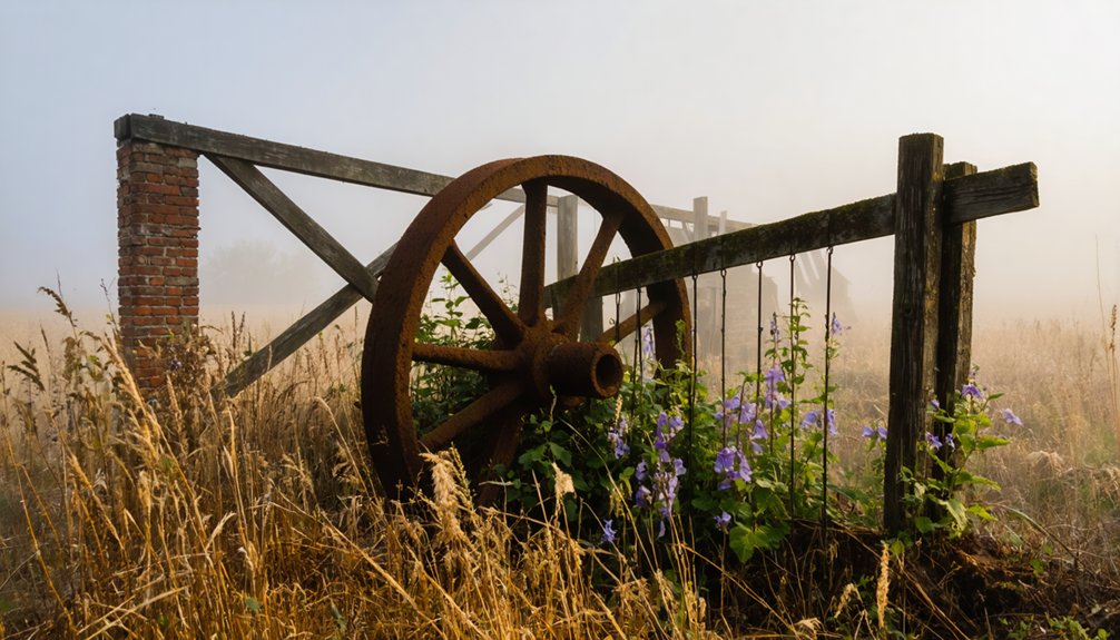
Buckhorn: Historic Creamery and Cemetery Photography Haven
You’ll find Buckhorn’s crumbling creamery standing as a monument to Iowa’s once-thriving dairy industry. Its weathered walls and collapsed roof sections create dramatic shadows perfect for summer photography.
The adjacent Civil War-era cemetery offers equally compelling compositions, with aged headstones emerging from tall grass beneath ancient trees.
Time your visit during golden hour to capture the haunting interplay of light filtering through the creamery’s broken windows and dancing across century-old grave markers.
Abandoned Church Architecture Details
The whitewashed church stands sentinel on a dusty corner where Buckhorn’s past refuses to fade completely. Its haunting silhouette rises beside the abandoned creamery and overgrown cemetery.
Built on land Shadrach Burleson donated in 1836, this church architecture exemplifies rural Iowa’s simple, stark design philosophy.
Though shuttered tight—it’s private property—you’ll find extraordinary photographic opportunities from the exterior.
The building’s decades-long abandonment creates an atmosphere that’s simultaneously beautiful and unsettling.
What makes these abandoned structures photographically compelling:
- Whitewashed walls contrast dramatically against Iowa’s summer skies
- Strategic corner positioning frames shots with creamery and cemetery ruins
- Deteriorating simplicity captures the American frontier’s fading footprint
- Eerie, cinematic quality appeals to urban exploration enthusiasts
Access Highway 64 in Jackson County, staying respectful of property boundaries while capturing your shots.
Buckhorn Creamery’s Historical Significance
Rising from the prairie as Jackson County’s economic powerhouse, Buckhorn’s Farmer’s Union Cooperative Creamery transformed this rural crossroads into one of America’s largest butter producers from the 1890s through the mid-20th century.
You’ll discover a cooperative that once served 700 patrons, employed 11 milk haulers across 17 routes, and churned out 34 million pounds of butter between 1899 and 1952. This wasn’t just industry—it was the town’s beating heart, hosting legendary annual picnics that drew up to 5,000 people.
Today, you’ll find *dairy heritage* etched into the graffiti-covered walls and scattered debris of the crumbling structure. Even *community nostalgia* endures, revived through Preston’s Buckhorn ice cream shop honoring those milk-hauling ancestors who built something remarkable before economics swept it away.
Summer Photography Tips Here
Stepping onto Buckhorn’s dusty grounds with camera in hand, you’re confronting a photographer’s paradox—two subjects frozen in time yet constantly shifting beneath Iowa’s summer sun.
Sunlight angles transform dramatically here; golden hour bathes weathered tombstones in amber warmth while midday glare exposes every crack in the creamery’s crumbling façade.
Lens selection matters intensely—wide-angles capture the cemetery’s sprawling desolation against endless fields, while macros reveal moss-covered engravings telling forgotten stories.
Capture these compositional elements:
- Graffiti-scarred creamery walls framed by overgrown prairie grass swaying in wind
- Whitewashed church standing defiant beside collapsing industrial ruins
- Cemetery stones casting long shadows across untended plots at dusk
- Drone perspectives revealing three structures positioned like chess pieces on abandoned land
Respect property boundaries, pack bug spray, and shoot during those extended summer daylight hours when ghosts feel closest.
Sunbury: Dance Hall Remnants and Railroad History
Nestled in Cedar County about 30 miles west of Davenport, Sunbury emerged as a quintessential railroad town when tracks first cut through Iowa’s fertile farmland. You’ll discover abandoned structures that whisper tales of prosperity—most importantly the dance hall remnants from 1895, which hosted community gatherings until 1964.
The ghost town history reveals a settlement that once thrived with fifty residents serving surrounding family farms. The Chicago, Rock Island, and Pacific Railroads brought economic energy here, while the Sunbury Bank operated from its 1901 brick building until the Great Depression crushed it.
Though the bank was razed around 2014, you can still explore the dance hall’s weathered remains. It’s perfect territory for summer wanderers seeking authentic Midwest railroad heritage without boundaries or restrictions.
Stiles: A Completely Vanished 1850s Settlement
Though hardly a trace remains on modern Iowa maps, Stiles once flourished in Davis County’s Grove Township as a self-sufficient frontier community. Founded around 1840 and named for Kernel Stiles S. Carpenter, the settlement peaked at 100 residents by 1858 before dwindling to just 30 souls by 1975.
Without ghost town conservation efforts, you’ll find minimal remnants:
- An abandoned schoolhouse stands forgotten at Peach Avenue and 233rd Street’s crossroads
- Stiles Cemetery preserves original settlers’ graves among weathered headstones
- Former post office and store buildings remain under Lister family ownership
- The Methodist Church’s foundation marks where community gatherings once echoed
Historic preservation here exists primarily through memory. This vanished settlement once boasted three stores, mills, doctors’ offices, and Iowa’s first rural telephone switchboard—all reclaimed by time.
Mount Pisgah: Mormon Pioneer Trail Rest Stop
Between 1846 and 1852, thousands of Mormon pioneers transformed a hillside near present-day Thayer into Iowa’s most significant trail settlement. You’ll discover Mount Pisgah at 1704 Mount Pisgah Road, where 2,000-3,000 exiles from Nauvoo carved dugouts into hillsides and broke hundreds of acres of prairie sod.
Between 1846 and 1852, Mormon exiles carved dugouts into Iowa hillsides, creating the trail’s largest settlement at Mount Pisgah.
Their pioneer resilience shines through despite staggering hardships—over 300 graves mark where disease and starvation claimed lives as travelers averaged just three miles daily through Iowa’s unforgiving landscape.
Today’s historic conservation efforts protect the cemetery where a 12-foot obelisk lists 63 named dead. You’re free to explore this Iowa DNR preserve along the 1,300-mile Mormon Pioneer National Historic Trail.
The spring that sustained desperate travelers still flows, offering you a tangible connection to westward-bound determination.
Planning Your Summer Ghost Town Adventure in Iowa
Your summer exploration of Iowa’s ghost towns demands strategic planning to maximize both historical discovery and practical accessibility. Navigate back roads through Jackson and Jones County while seasonal weather provides ideal conditions for photographing abandoned creameries and weathered cemeteries. You’ll find limited services in these remote areas, so pack provisions and fuel up beforehand.
As you venture further, keep an eye out for abandoned places in Iowa that tell stories of the past, from old railroads to forgotten schools. Each site offers a unique glimpse into the lives once lived there, inviting you to delve deeper into the local history. Remember to bring a camera; these hidden gems provide fantastic opportunities for capturing the beauty of decay.
Enhance your adventure by combining multiple sites:
- Drone captures of Buckhorn’s historic creamery against golden prairie grass
- Rockville’s crumbling mill framed by dense woodland shadows
- Weathered headstones emerging from overgrown cemetery paths
- Sunset light filtering through skeletal remains of abandoned structures
Extend your journey by visiting nearby attractions like Maquoketa Caves State Park or Motor Mill Historic Site. Sample local cuisine in towns like Elkader between ghost town stops, creating a complete historical immersion experience.
[ORIGINAL TEXT]
Frequently Asked Questions
Are Pets Allowed When Exploring Iowa’s Ghost Towns During Summer?
Yes, you’ll find Iowa’s ghost towns generally welcome pets during summer exploration. There’s no specific pets policy restricting access, but you’re responsible for pet safety. Keep them leashed and follow standard state park regulations when applicable.
What Time of Day Offers the Best Lighting for Ghost Town Photography?
Golden hour lighting delivers stunning results—shoot one hour after sunrise or before sunset. You’ll capture warm, soft illumination that enhances weathered textures. Sunset photography creates dramatic shadows and rich tones, perfectly highlighting Iowa’s abandoned structures.
Do Any Iowa Ghost Towns Charge Admission or Parking Fees?
You’ll breathe easier knowing Iowa’s authentic ghost towns don’t trap you with access fees or parking costs. These abandoned settlements remain genuinely free to explore, letting you wander without constraints—unlike commercial haunted attractions that’ll empty your wallet.
The desolate charm of abandoned sites in Iowa winter invites intrepid explorers to uncover the stories etched in the frost. As you navigate through the remnants, the stark beauty of the landscape melds with the echoes of history, creating an atmosphere that feels almost magical. Each location offers a unique glimpse into the past, urging you to delve deeper into the mysteries that time has left behind.
Are Restroom Facilities Available Near These Abandoned Town Sites?
Restroom availability varies considerably. You’ll find facilities at renovated trailheads like Malvern’s depot, Waterworks Park, and Hillsdale’s community church. However, most abandoned sites lack nearby amenities—you’ll need to plan ahead for remote locations.
Can You Camp Overnight at or Near Iowa Ghost Town Locations?
You’ll find limited overnight options at Iowa’s 200+ ghost town sites due to access restrictions and historical preservation concerns. However, you can camp at nearby Spook Cave’s campground or Sleepy Hollow RV Park while exploring abandoned settlements.
References
- https://kids.kiddle.co/List_of_ghost_towns_in_Iowa
- https://www.onlyinyourstate.com/experiences/iowa/ia-ghost-town
- https://freepages.history.rootsweb.com/~gtusa/usa/ia.htm
- http://www.iowapbs.org/article/8600/local-legends-around-iowas-haunted-locations
- https://www.discoverguthriecounty.org/ghosttowns
- https://pubs.lib.uiowa.edu/annals-of-iowa/article/id/6960/download/pdf/
- https://www.youtube.com/watch?v=L883pwCPOwE
- https://www.youtube.com/watch?v=1J0Qx64ZrwI
- https://www.findagrave.com/cemetery/2374194/rockville-cemetery
- https://www.youtube.com/watch?v=eh_YlgRKjBU