You’ll find Massachusetts’ most haunting ghost towns revealed when winter strips away summer’s concealing vegetation. Explore Dogtown’s 3,000-acre wilderness near Gloucester, where massive boulders bear Depression-era inscriptions among crumbling foundations. Trek to Catamount in the Berkshires, where America’s first schoolhouse flew the flag in 1812. Visit Dana off Route 32A, where four miles of paved trails connect cellar holes from the drowned Quabbin towns. Stand at Enfield Lookout and imagine an entire community resting forty feet beneath the frozen reservoir—pack snowshoes, waterproof layers, and discover the stories etched into these forsaken landscapes.
Key Takeaways
- Dogtown in Gloucester offers 3,000 acres of wilderness trails with Depression-era rock inscriptions and colonial foundation stones visible in winter.
- Dana Ghost Town near Quabbin features nearly four miles of paved trails connecting cellar holes, granite steps, and marked historic sites.
- Catamount settlement atop Colrain Mountain reveals cellar holes, cemetery remnants, and the site of Massachusetts’s first schoolhouse to fly the U.S. flag.
- Whitewash Village on Monomoy shows brick foundations and eroding coastal ruins from an 1860s hurricane that buried the harbor in sand.
- Norton Furnace displays 1825 industrial ruins along Three Mile River, including remnants of a 25-house settlement abandoned in the 1890s.
Dogtown: Gloucester’s Mysterious 3,000-Acre Wilderness
Follow the criss-crossing trails to discover Roger Babson’s Depression-era inscriptions carved into massive rocks—messages like reminders from another era.
The archaeological significance runs deeper: Indigenous peoples occupied this land 12,000 years ago.
Winter strips away the forest’s disguise, revealing foundation stones and the watershed feeding Cape Ann’s reservoirs.
The Commons Settlement established roots here in 1642, drawn by the area’s abundant water sources, before fading into history within 50 years after the Revolutionary War.
Sacred stones and boulders, like Peters Pulpit and Whales Jaw, held spiritual significance for Indigenous peoples who believed they contained spiritual power.
Bring snowshoes—this terrain doesn’t forgive unsteady footing.
Catamount: Remote Colonial Settlement in the Berkshire Hills
Deep in the Berkshire Hills, you’ll find Catamount clinging to the slopes of Colrain Mountain, where mid-1700s settlers carved out 50-acre homesteads and built Massachusetts’s first schoolhouse to fly the American flag in 1812.
The rugged terrain that once sustained hardy Scotch-Irish farmers now challenges winter hikers with steep, forested trails through Catamount State Forest—snowshoes essential when drifts pile high around weathered cemetery stones.
I’ve traced these same paths where former residents gathered every five years since 1875, their Old Home Days festivals a proof to the mountain’s grip on those who once called it home.
Near the old cemetery, you can still find the site of the early church built close to Colrain Mountain, where the first Presbyterian congregation gathered for worship before abandoning the settlement.
The settlement was abandoned in the early 20th century before Massachusetts purchased the land in 1967 to create the state forest that protects it today.
Historic Schoolhouse Flag Site
Perched atop Colrain Mountain in the Berkshire Hills, Catamount’s weathered schoolhouse once made quiet history when it became the first in the nation to fly the United States flag in 1812. You’ll find only foundations now, but Adelaide R. Kemp’s documentation preserves this patriotic milestone.
The site whispers stories that blur fact and urban legends—tales of Scotch-Irish Presbyterian children reciting lessons beneath that historic banner, their families having fled persecution for worship freedom.
Winter reveals what summer foliage conceals: stone markers, cellar holes, and the adjacent cemetery where those early settlers rest. Despite minimal preservation efforts, you can still trace the schoolhouse’s prominent location through scattered remnants. The mountain terrain that supported this isolated community also provided ideal habitat for cougars, which historically ranged throughout dense forested regions of western Massachusetts before local extinctions. Visiting requires user acknowledgment of the remote terrain and weather conditions typical of this isolated settlement.
Trek through Catamount State Forest to stand where American symbolism first unfurled above a remote classroom, embodying the independence these colonists sacrificed everything to claim.
Rugged Terrain and Trails
The journey to Catamount tests your resolve before you glimpse a single foundation stone. Hand-cut trails from the 1930s ski area wind through Catamount State Forest’s unforgiving terrain, where winter transforms the Berkshire Hills into a domain of crystalline beauty and genuine danger.
You’ll navigate steep grades approaching Mt. Fray’s 1,893-foot summit, where ice formations cloak abandoned cellar holes and forgotten farming terraces. Settlement began in 1765, when New England families claimed this remote land that others considered undesirable.
Trail safety isn’t optional here—it’s survival. The same remoteness that isolated those 50 families now demands proper gear, navigation skills, and winter preparedness.
Snowmobilers share these rugged paths, their tracks offering reassurance you’re not completely alone. Yet that isolation? That’s precisely what you came for.
The Commonwealth manages these trails through Mohawk Trail State Forest, preserving both wilderness and the ghostly remnants of perseverance. From Mt. Fray’s peak, you can witness spectacular views of the Hudson Valley that once drew aviators and entrepreneurs to this unforgiving landscape.
Whitewash Village: Lost Fishing Community of Monomoy Island
When you stand at Monomoy Point today, scanning the winter shoreline for traces of Whitewash Village, you’re searching for a community that nature literally swallowed whole.
Around 1860, a hurricane drove massive sand deposits into Powder Hole harbor, choking the deep anchorage that had sustained two hundred fishermen and their families for generations.
The fish vanished with the harbor’s depth, and within years, the villagers abandoned their whitewashed homes to the encroaching dunes—leaving only brick foundations and rotting wharf timbers that surface at low tide.
The village’s visual history survives through Giddings Ballou’s illustrations, which captured fishermen’s daily struggles and shipwreck survivors in an 1864 Harper’s Monthly Magazine feature.
Overlooking this ghost settlement stands the 1849 cast-iron lighthouse, one of America’s earliest brick-lined towers, painted red in 1882 and now maintained as a historic landmark within the wildlife refuge.
Hurricane Destruction and Abandonment
On a winter’s day in 1860, Whitewash Village met its end not through gradual decline but in a single, catastrophic storm that redrew Monomoy Island’s coastline forever. The hurricane swept away the northwest point and buried Powder Hole harbor under mountains of sand.
Transforming the deep anchorage that once sheltered 200 ships into useless shallows. Fish vanished from waters that had sustained the community’s economy.
You’ll find urban legends among locals about the village’s sudden death—haunted tales of families floating their homes across the water to escape.
Today, brick foundations emerge at low tide near what fishermen call their best spot, though few realize they’re casting lines over a drowned settlement where children once attended school and wreckers traded their salvage.
Shifting Coastal Geography Today
Standing at Chatham’s shore today, you’ll witness Monomoy Island playing a geological game of connect-and-disconnect with the mainland—a restless barrier beach that shifts with each nor’easter and hurricane.
Tidal erosion has claimed Whitewash Village entirely, transforming Powder Hole harbor into a sand-filled memory.
At low tide, you can spot wood fragments from fishermen’s shacks breaking through the surface, while brick foundations rest beneath the waves—now Massachusetts’s most unusual fishing spot.
The shoreline shifts here aren’t measured in decades but in seasons.
Monomoy Point Light stands as the lone witness to these transformations, watching the land reshape itself according to the Atlantic‘s whims.
You’re free to explore this wild coastline, but remember: the same forces that erased a thriving community continue their work today.
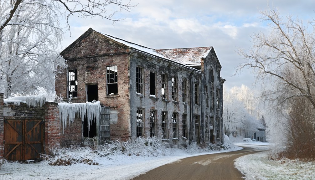
Dana: The Most Accessible Quabbin Reservoir Ghost Town
The snow-dusted ruins of Dana Common rise from the forest floor like grave markers for an entire town. You’ll find this ghost town off Route 32A at Gate 40—park and hike nearly four miles on paved paths through what 2,000 displaced residents left behind in 1938.
Four miles of paved trails lead through cellar holes and stone foundations where 2,000 people once called home.
Stone posts bearing vintage photos mark where the Eagle Hotel once stood. You’ll descend into cellar holes, trace granite steps to nowhere, and follow old stone walls separating phantom properties.
This isn’t casual urban exploration—it’s historical preservation through public access, managed respectfully by Mass DCR.
The stone marker says it plainly: “To all those who sacrificed their homes and way of life.” Greater Boston needed water; Dana disappeared beneath Quabbin Reservoir.
Winter makes the ruins particularly haunting, their foundations stark against fresh snow.
Enfield: Submerged Ruins Beneath the Quabbin Waters
Unlike Dana’s visible cellar holes, Enfield demands something darker from winter visitors—imagining an entire town forty feet beneath the ice you’re standing on. The reservoir flooding erased everything: homes, churches, the Route 21 corridor connecting neighbors who’d gathered for one final farewell ball before their world disappeared.
Now you’ll stand at Enfield Lookout, squinting across frozen expanse where 412 billion gallons press down on submerged architecture— a cemetery crypt entrance, stone foundations, streets walked by over 2,500 displaced souls.
Winter reveals the reservoir’s true scale. That vast white silence isn’t peaceful; it’s memorial. The state razed every building, cleared every tree, burned the debris before letting Swift River Valley drown.
What remains exists only in 1929-1946 photographs and your winter contemplation of absence.
Norton Furnace: Remnants of Massachusetts’ Industrial Past
Where Enfield drowned beneath deliberate flooding, Norton Furnace simply starved—a slower erasure that left skeletal proof above ground. You’ll find this ghost settlement along a quiet tributary near Three Mile River, where Annes A. Lincoln, Jr. sparked an industrial revolution in 1825.
His iron furnace employed twenty-five workers, while the Crocker Family’s copper mill rolled blanks for U.S. currency. By 1850, twenty-five houses clustered around a general store and eventual train station.
Then the exodus: Norton Copper Works fled to Worcester in the 1890s, the furnace company toward Boston.
What remains offers pure industrial archaeology—no admission fees, no guided tours. Just you, a hiking trail, and historic preservation frozen in December silence.
Massachusetts’ manufacturing ambitions, rendered honest by abandonment.
Planning Your Winter Ghost Town Adventure in Massachusetts
Before you chase frost-silvered ruins across Massachusetts, you’ll need more than romantic notions about industrial decay. Pack insulated boots and snowshoes for traversing 12-inch drifts around Quabbin’s submerged towns, where microspikes grip icy trails and trekking poles steady your descent past Enfield’s stone foundations.
Snow-covered landscapes demand waterproof layers—coastal winds at Dogtown hit 50 mph, while Catamount’s inland forests plunge below zero. Grab your free Quabbin permit at the gatehouse, respect dawn-to-dusk hours at state forests, and carry emergency beacons where cell service dies.
Winter wildlife—coyotes prowling scarce territories—add edge to your exploration. Load extra headlamp batteries; February’s 4:30 PM sunsets won’t wait while you’re photographing Dana’s frozen cemetery markers.
Frequently Asked Questions
Are Ghost Town Visits in Massachusetts Free or Do They Require Permits?
Wander freely—Massachusetts ghost towns welcome you without entry fees or permit requirements. You’ll find trails open year-round at Dogtown, Catamount, and Quabbin. Though guided tours aren’t typically offered, you’re free to explore these haunting landscapes independently.
What Winter Gear Is Essential for Exploring Abandoned Massachusetts Settlements?
You’ll need layered winter clothing—thermal base layers, waterproof boots, and insulated jacket—plus an emergency kit with flashlight, first-aid supplies, and backup phone charger. I’ve learned frozen fingers ruin exploration fast, so pack extra gloves.
Can You Camp Overnight Near These Ghost Town Locations in Winter?
Winter camping near Massachusetts ghost towns isn’t permitted at most locations—seasonal closures and permit restrictions block overnight stays. Safety considerations include extreme cold exposure and limited emergency access. You’ll find Cape Ann Camp Site offers year-round alternatives nearby.
Are the Ghost Towns Safe to Visit Alone During Winter Months?
Visiting alone isn’t recommended—winter safety demands backup when temperatures plummet and cell service vanishes. Alone exploration in abandoned Massachusetts towns means you’re hours from help if conditions turn deadly, roads ice over, or equipment fails.
Which Ghost Towns Are Wheelchair or Stroller Accessible in Winter Conditions?
You’ll find wheelchair friendly pathways at Salem’s memorial sites and stroller accessible trails through Malcolm Preserve’s maintained routes. These winter-ready destinations let you explore haunted history independently, rolling freely through snow-dusted grounds where Massachusetts’s ghostly past whispers around you.
References
- https://www.tripadvisor.com/Attractions-g28942-Activities-c47-t14-Massachusetts.html
- https://bostonuncovered.com/ghost-towns-massachusetts/
- https://travelnoire.com/where-was-spirited-filmed
- https://www.pnlpaintball.com/winter-ghost-town
- https://www.youtube.com/watch?v=T4yhm_S-dHc
- https://historyofmassachusetts.org/ghost-towns-massachusetts/
- https://historicipswich.net/2021/01/23/dogtown-its-history-and-legends/
- https://babsonassoc.org/indegeneous-presence-dogtown/
- https://www.bostonhiddengems.com/blog/dogtown-ma
- https://travelnoire.com/abandoned-town-in-northern-massachusetts


