Delaware’s underwater ghost towns include Zwaanendael, a Dutch whaling settlement from 1631 destroyed by conflict with the Lenape tribe in 1632, and Glennville, a modern floodplain community evacuated in 2004 after repeated flood damage. You’ll find significant maritime archaeological sites like the Roosevelt Inlet Shipwreck (British merchant Severn, 1772) with over 66,000 recovered artifacts, and the HMS De Braak (1798) at 90 feet depth. Pea Patch Island‘s fortifications and systematic underwater surveys document these submerged sites. Preservation efforts through specialized techniques reveal Delaware’s colonial and maritime history.
Key Takeaways
- Zwaanendael, Delaware’s first settlement founded by Dutch colonists in 1631, was destroyed in 1632 and now lies submerged underwater.
- Roosevelt Inlet Shipwreck yielded over 66,000 artifacts from the British merchant ship Severn, which wrecked in 1772.
- HMS De Braak capsized in 1798 near Cape Henlopen at 90 feet depth, killing 46 crew members.
- Glennville on Bread and Cheese Island was evacuated by 2004 after repeated flooding, with homes demolished in 2005.
- Underwater archaeology uses sonar and magnetometers to document submerged sites, leading to National Register listings in 2006.
The Roosevelt Inlet Shipwreck Discovery
In fall 2004, a routine beach replenishment project at Lewes Beach inadvertently exposed one of Delaware’s most significant maritime archaeological discoveries. Dredging operations near Roosevelt Inlet pumped sand onto shore, revealing thousands of artifacts from an unknown shipwreck.
Beachcombers recovered over 40,000 objects and donated them to Delaware authorities. This underwater archaeology effort culminated in systematic investigations during 2005 and 2006, yielding 26,000 additional artifacts through diving operations.
Together, beachcombers and diving teams recovered over 66,000 artifacts from the site during 2004-2006, donated to Delaware authorities for preservation.
Researchers identified the vessel as the Severn, a British merchant ship that ran aground in March 1772. The cargo included German stoneware, British glass bottles, and goods from China and South Africa. Among the notable finds were pewter shoe buckle frames that reflected 18th-century fashion trends, as these decorative items both secured shoes and adorned attire.
Marine conservation efforts led to National Register listing in 2006, preserving this 2.9-acre site documenting colonial maritime history. The State of Delaware published comprehensive documentation of the Roosevelt Inlet Shipwreck investigations to ensure long-term preservation of the site’s historical data.
Eighteenth-Century Maritime Tragedies Along the Delaware Coast
The eighteenth century transformed Delaware’s coastline into a maritime graveyard, with documented evidence showing thirty-one vessels lost between 1700 and 1799 in waters surrounding Cape Henlopen alone.
You’ll find the most catastrophic incidents concentrated between 1785 and 1798, when environmental hazards combined with human error to create conditions that claimed hundreds of lives.
Archaeological surveys have identified wreck sites scattered across the Roosevelt Inlet, each vessel representing a specific combination of navigational failure, weather phenomena, and operational inadequacy recorded in period shipping logs and survivor testimonies.
Among the most significant discoveries is the HMS De Braak, a British sloop-of-war that sank in 1798 carrying naval equipment and personal effects that now provide insights into eighteenth-century maritime operations.
The Abandoned Shipwrecks Act, enacted in 1988, designated these historic wrecks in state coastal waters as property of Delaware, prohibiting artifact removal while emphasizing preservation for future generations.
Roosevelt Inlet Shipwreck Discovery
When beach replenishment operations pumped sand onto Lewes Beach during fall 2004, dredging equipment inadvertently exposed thousands of artifacts from an unknown shipwreck scattered across the shoreline.
You’ll find this discovery led underwater archaeologists to locate the wreck site near Roosevelt Inlet in 2005, documenting its position before environmental impact assessments could proceed.
The 2006 investigation recovered cargo artifacts while marine biology studies confirmed the site’s ecological significance.
Over 40,000 artifacts surfaced from dredging spoils, revealing an 18th-century British merchant vessel—likely the Severn—that ran aground in 1774.
The wreck earned National Register listing as 7S-D-91A, encompassing 2.9 acres.
You’re witnessing Delaware’s oldest-known shipwreck, where approximately 56,000 beachcomber-donated artifacts now document colonial maritime commerce.
The ship’s cargo included goods from Britain, Holland, Germany, South Africa, and China, reflecting the extensive international trade networks of colonial America.
Southeastern Archaeological Research Inc. was contracted to investigate the wreck and determine details of the vessel’s construction.
Thirty-One Vessels Lost
Delaware’s eighteenth-century coastline claimed at least thirty-one documented vessels between 1700 and 1799, establishing the region as one of colonial America’s most treacherous maritime corridors. You’ll find these wrecks resulted from hazards that challenged even experienced captains steering Delaware Bay’s shipping lanes.
The period’s devastating losses included:
- Faithful Steward (1785) – 181 souls lost when celebrating crew lost control, grounding 150 yards offshore
- HMS De Braak (1798) – Capsized in minutes during squall, killing up to 46 including Commander Drew
- Shifting sandbars and shoals – Brandywine Shoal and similar formations created unpredictable marine sailing obstacles
- Failed salvage technology – British Royal Navy’s 1798 recovery attempt and thirty subsequent efforts couldn’t raise De Braak
Human error, severe nor’easters, and dense fog compounded these natural dangers throughout the century. The De Braak sank in 90 feet of water off Cape Henlopen on May 25, 1798, going down within minutes as open hatches filled with seawater. These vessels, ranging from schooners to steamboats, represent centuries of maritime activity along Delaware’s treacherous shores.
Zwaanendael: Delaware’s First Submerged Settlement
You’ll find Delaware’s earliest European settlement beneath the waters near present-day Lewes, where Dutch colonists established Zwaanendael in 1631 as a whaling station at the mouth of Hoornkill River.
The fortified compound housed 32 men under Captain David Pietersz. de Vries until escalating tensions with the Lenape tribe erupted in 1632 after Commander Gilles Hossitt’s severe response to a tribal incident.
The conflict originated from a dispute over a tin plate, which ultimately escalated into violence that would doom the entire colony.
When de Vries returned on December 5, 1632, he discovered only charred remains and evidence of the massacre that ended Delaware’s first permanent settlement attempt after less than two years.
The tragedy left only two survivors, Pierre and Hendrick Wiltsee, who were boys at the time of the attack.
Dutch Whaling Colony Origins
Established in 1631 along Blommaert’s Kill (now Lewes Creek) near Cape Henlopen, Zwaanendael—archaic Dutch for “Valley of the Swans”—represented the Dutch West India Company‘s first systematic attempt to exploit Delaware Bay’s whale populations for commercial profit.
Captain David Pietersz. de Vries transported 28-32 settlers aboard the Walvis, an eighteen-gun vessel that departed Holland on December 12, 1630.
The settlement’s operational framework reflected Dutch trade priorities:
- Palisaded fortification featuring the Dutch red lion rampant emblem
- Dormitory and cook house supporting colonial workforce
- Grain cultivation and tobacco production supplementing whaling revenues
- Strategic positioning at Delaware Bay’s mouth maximizing marine resource access
This colonial architecture embodied economic autonomy before governmental restrictions dominated regional development.
Directors Samuel Blommaert and Samuel Godyn purchased extensive Lenape territories in 1629, establishing commercial sovereignty.
Native American Conflict Escalation
The settlement’s commercial ambitions collapsed within months when cultural misunderstanding triggered devastating violence.
When Lenape removed a Dutch coat-of-arms plate—possibly for pipe-making during their Susquehannock conflict—colonists interpreted this as hostile provocation.
The Lenape attempted cultural diplomacy by delivering the alleged offender’s head, seeking to preserve indigenous alliances and trade networks.
Dutch rejection escalated tensions fatally. In 1632, attackers killed all 28-32 settlers, leaving only scattered remains and two surviving boys.
You’ll find David Pietersz de Vries discovered charred bones and burned structures on December 5, 1632.
Rather than retaliate, he negotiated peace treaties—defying patroon demands for vengeance under Charter Article XXV.
The Dutch West India Company refused punitive action, ultimately forcing the patroonship’s abandonment until 1655’s resettlement efforts.
1632 Settlement Destruction
Departing Holland on December 12th, 1630, the Walvis carried twenty-eight men and supplies toward what would become Delaware’s first European settlement. Following ancient trade routes through the West Indies, settlers reached Blommaert’s Kill and established Zwaanendael—”Valley of the Swans”—on colonial settlement pathways connecting Cape Henlopen to the Delaware River mouth.
You’ll find evidence of their ambitious construction:
- Palisaded fort marked with Holland’s “red lion, rampant”
- Dormitory and cook house for whale hunting operations
- Trading post near present-day Lewes
- Agricultural grounds for crop cultivation
When David Pietersz de Vries arrived December 5th, 1632, he discovered only charred remains. The colony lasted less than two years before complete destruction.
This documented site represented Delaware’s oldest land transaction, predating Maryland’s charter by three years.
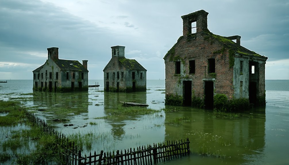
From Flood Plain to Ghost Town: The Story of Glennville
Nestled on Bread and Cheese Island along the east bank of Red Clay Creek in New Castle County, Glennville occupied one of Delaware’s most precarious locations—an active floodplain just south of Route 4 near Stanton.
At just 20 feet elevation, residents faced documented flooding events since 1937. Hurricane Floyd devastated the community in 1999, but Tropical Storm Henri on September 15, 2003, delivered the final blow—destroying homes and rendering the settlement uninhabitable.
You’ll find no underwater agriculture or submerged art installations here, just empty land reclaimed by nature. State and local governments executed systematic property buyouts, evacuating the entire population by 2004.
Demolition commenced in 2005, reducing Glennville to zero residents. This organized abandonment represents Delaware’s recognition that some locations demand retreat rather than resistance.
Pea Patch Island’s Forgotten Fortifications
While Glennville’s abandonment illustrates modern Delaware’s retreat from persistent flooding, Pea Patch Island demonstrates an opposite historical impulse—the determination to fortify unstable ground through engineering intervention.
You’ll find this 178-acre marshland positioned strategically for underwater navigation control, where military engineers spent decades battling mud and river currents to protect maritime commerce routes to Philadelphia and Wilmington. The fortification effort consumed over $2 million between 1847-1860, with foundation pilings alone exhausting initial congressional appropriations.
The pentagon-shaped masonry fort’s construction revealed engineering ambition:
- Engineers flooded the entire island to achieve stable pile foundations
- A controllable moat with sluice gates provided defensive flooding capability
- Five bastions covered six acres of fortified ground
- Seawalls and dykes prevented Delaware River encroachment
New Jersey’s 1836 ownership claim temporarily halted construction—federal marshals physically removing Army Corps engineers from contested territory.
Archaeological Investigations and Artifact Recovery
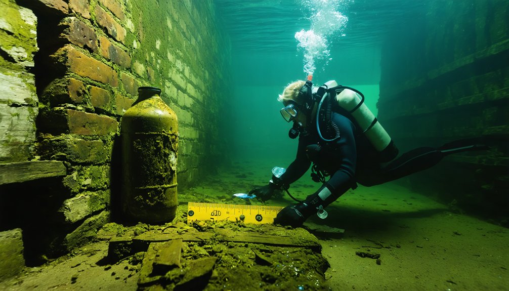
Below Delaware’s waterways, systematic archaeological investigation has transformed casual beach finds into documented historical resources. When 40,000 artifacts washed onto Lewes Beach, you witnessed how the Division of Historical and Cultural Affairs responded with methodical surveys.
They deployed sonar and magnetometers, located the eighteenth-century Roosevelt Inlet shipwreck, and documented 80% of undisturbed materials offshore. You’ll find artifact preservation requires desalination, freeze-drying, and chemical treatments to stabilize recovered items.
Through sediment analysis and hydro probe surveys, archaeologists determined the hull structure had deteriorated, yet mapped precise artifact distribution across eleven excavated grid squares. This evidence-based approach earned National Register listing in 2006.
Your access to these submerged sites depends on professionals documenting them before deterioration destroys irreplaceable historical evidence forever.
Delaware River Military Installations Lost to Time
Along the Delaware River‘s strategic waterways, Fort Mifflin emerged as the cornerstone of America’s coastal defense infrastructure, anchoring a multi-installation system that protected Philadelphia’s maritime approaches for 179 years. This coordinated network defended against foreign powers threatening your commercial freedom and sovereignty.
The installation network included:
- Fort Billings – First defensive position lost to British naval assault in 1777
- Chevaux-de-frise barriers – Congress-authorized underwater navigation obstacles blocking enemy warships
- Fort Mercer and Fort Delaware – Complementary positions creating overlapping fields of fire
- Harbor Defenses batteries – Spanish-American War-era installations with 3-inch guns and modern masonry fortifications
Historical wreck preservation efforts now document these submerged defensive structures. Between 1780-1800, 50% of coastal defense funding strengthened Philadelphia’s perimeter, demonstrating the installations’ critical strategic value before technological obsolescence rendered them unnecessary after 1921.
Preserving Delaware’s Underwater Heritage

Beneath Delaware’s tidal waters, the Delaware Underwater Archaeology Program (DUAP) employs systematic survey methodologies—sonar imaging, magnetometer detection, and remote sensing technologies—to locate and document submerged cultural resources across 782 square miles of state-controlled waterways.
You’ll find diver teams conducting site identification while evaluating preservation threats from water pollution, marine biodiversity interactions, and unauthorized salvage activities.
The Delaware Antiquities Act protects these sites, requiring permits for surveys and ensuring compliance with federal preservation standards. Conservation labs stabilize recovered artifacts through desalination and freeze-drying protocols.
You can access documented collections, field notes, and spatial data under stewardship programs that balance scientific research with responsible diver engagement. Updated curation guidelines effective March 2025 govern artifact handling, while Historic Preservation Fund grants support ongoing compliance surveys and in-situ preservation initiatives.
Frequently Asked Questions
Can Recreational Divers Legally Explore Underwater Ghost Town Sites in Delaware?
You’re chasing phantoms—Delaware has no documented underwater ghost towns to explore. Recreational diving remains legal in state waters, but illegal exploration of protected military sites like Pea Patch Island undermines conservation efforts and risks federal penalties.
When it comes to capturing the eerie beauty of abandoned places, colonial ghost town photography tips can enhance your skills. Focus on the interplay of light and shadow to convey a haunting atmosphere, and remember to explore different angles to tell a story. With careful composition, even the remnants of a once-thriving settlement can transport viewers to a different time.
How Does Delaware’s Underwater Heritage Compare to Other Mid-Atlantic States?
Delaware’s underwater heritage differs markedly—you’ll find ancient shipwrecks and underwater flora rather than submerged towns. Pennsylvania’s Raystown Lake displaced thousands, while Delaware’s Glenville involved minimal submersion compared to larger Mid-Atlantic dam projects.
What Marine Life Currently Inhabits These Submerged Historical Sites?
You’ll discover shipwrecks transformed into thriving artificial reefs where marine biodiversity flourishes—corals colonize hulls, fish seek shelter in structures, and various organisms fill distinct ecological niches. Atlantic sturgeon, cownose rays, and tropical species regularly visit these submerged sanctuaries.
Are There Organized Tours Available for Delaware’s Underwater Archaeological Sites?
You can’t dive the sites directly, but you’ll explore HMS DeBraak’s artifacts at Zwaanendael Museum through tours. DUAP’s archaeological techniques and underwater photography document these protected wrecks, preserving your access to Delaware’s submerged heritage through exhibits.
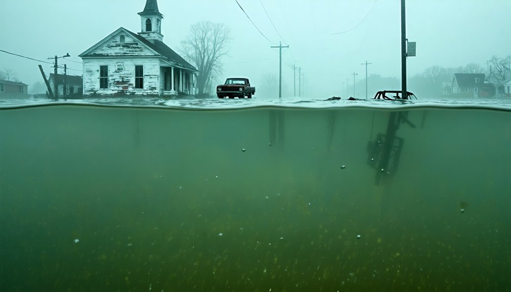
How Has Climate Change Affected Preservation of Delaware’s Submerged Towns?
Climate change acts like an erasing tide on Delaware’s submerged history. You’ll find rising sea levels and coastal erosion accelerating site degradation at locations like Glenville and Woodland Beach, where documented flood events prevent systematic archaeological preservation efforts.
References
- https://history.delaware.gov/wp-content/uploads/sites/179/2019/02/volume1.pdf
- https://99wfmk.com/delaware-ghost-town-and-abandoned-mine/
- https://www.youtube.com/watch?v=ex8Hld_imPU
- http://freepages.rootsweb.com/~gtusa/history/usa/de.htm
- https://www.youtube.com/watch?v=PXR282drWyg
- https://www.narratively.com/p/the-park-built-on-forgotten-ghost-towns
- https://www.visitkeweenaw.com/listing/delaware-the-ghost-town/515/
- https://history.delaware.gov/archaeology/roosevelt-inlet-shipwreck/
- https://en.wikipedia.org/wiki/Roosevelt_Inlet_Shipwreck
- https://www.atlasobscura.com/places/roosevelt-inlet-shipwreck