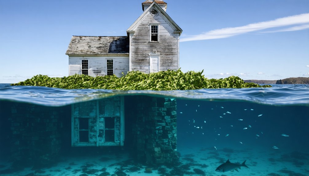
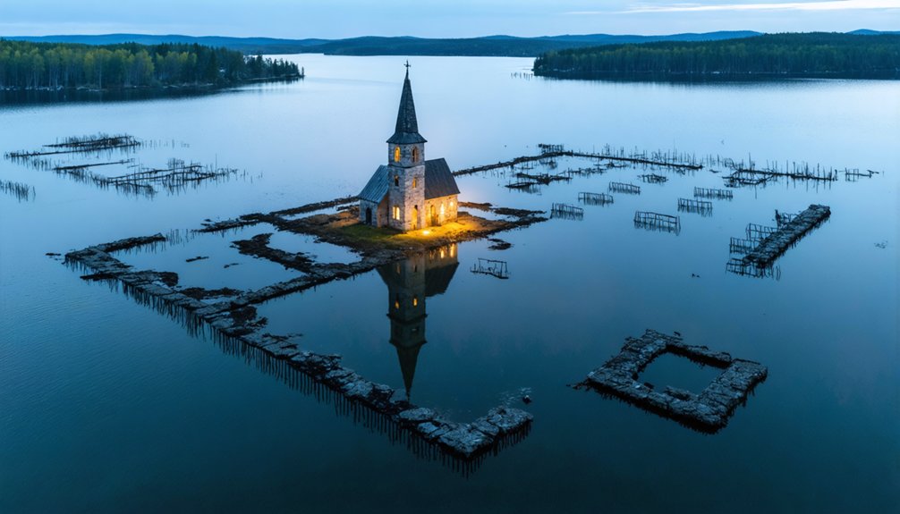
You’ll find three complete townships—Flagstaff Village, Dead River Plantation, and Bigelow—submerged beneath Flagstaff Lake’s 20,300-acre surface. Central Maine Power flooded these settlements in 1950 after constructing Long Falls Dam, displacing approximately 300 residents and destroying homes, farms, and mills dating to the early 1800s. When water levels drop more than 6 feet below elevation 1,146 ft, you can observe exposed foundations, street outlines, and artifacts resting up to 50 feet below normal surface levels. The archaeological evidence reveals how mid-20th century hydroelectric development systematically erased entire communities.
Key Takeaways
- Flagstaff Lake, Maine’s largest man-made lake, submerged Flagstaff Village, Bigelow, and Dead River Plantation when Long Falls Dam flooded 20,300 acres in 1950.
- Approximately 300 residents were displaced through eminent domain as Central Maine Power created the reservoir for hydroelectric generation starting in 1949.
- When water levels drop more than 6 feet below normal elevation, foundations, street outlines, and artifacts become visible at the lake’s surface.
- Submerged structures rest nearly 50 feet underwater, including homes, mills, barns, and infrastructure from settlements established in the early 1800s.
- The underwater ghost towns serve as archaeological sites, with visible remnants during low water periods documenting forced community displacement for development.
The Valley That Disappeared: Flagstaff’s Story Before the Flood
During the early 1800s, settlers arrived in Maine’s Dead River Valley, establishing what would become Flagstaff Village and surrounding communities. You’ll find historical records documenting Myles Standish’s construction of gristmills and sawmills powered by Mill Stream’s hydrology.
Mill Stream’s flowing waters turned the gristmills and sawmills that powered Flagstaff Village’s early industrial foundation.
The settlements expanded systematically around Dead River and Bigelow Plantation, where rich alluvial soil and abundant timber resources supported economic development.
The community operated independently through stores, schools, and residential infrastructure. Community memories center on their final July 4, 1949 Old Home Days celebration—featuring parades, music, and fireworks. These local traditions exemplified the autonomous social structures residents maintained.
Family homes, the schoolhouse, and shared landmarks formed the physical framework of daily life. You can verify this tight-knit population sustained itself through decentralized cooperation until Central Maine Power’s 1930 acquisition process initiated their eventual displacement. The displacement involved door-to-door legal negotiations, systematic relocation of personal possessions, and clear cutting of the land in preparation for flooding. The Long Falls Dam, completed in 1950, ultimately transformed the thriving valley into the vast reservoir known as Flagstaff Lake.
How Long Falls Dam Erased Three Townships From the Map
When Central Maine Power Company broke ground on Long Falls Dam in 1949, the timeline for erasing three townships from Maine’s landscape compressed into a devastating 18-month sequence. You’ll find the hydroelectric impact began with clearing operations in 1948, followed by systematic demolition of schoolhouses and infrastructure.
Smoke from burning brush blanketed Flagstaff through summer 1949 as crews eliminated what stood in the reservoir’s path.
The Dead River’s diversion in fall 1949 triggered the final phase. By 1950, gates closed and waters consumed Flagstaff, Dead River Plantation, and Bigelow—communities Benedict Arnold himself founded.
Environmental consequences weren’t limited to flooded homes and businesses. The artificial lake created north of Bigelow Mountains became a massive reservoir feeding controlled water flow to hydroelectric turbines downstream. CMP bought properties and sold homes back to families for relocation to higher ground. Unresolved compensation disputes left structures standing as floodwaters rose, creating Maine’s largest man-made lake while permanently submerging historic settlements beneath controlled flows powering downstream turbines.
Forced Exodus: The Human Cost of Creating Maine’s Fourth Largest Lake
The physical destruction of infrastructure concealed a more profound human catastrophe: the forced displacement of approximately 300 residents whose families had cultivated the Dead River valley for generations. You’ll find this represents governmental authority overriding individual land rights—state power legitimized through electrical demand and flood control justifications.
The July 1949 final community meeting documented residents’ compulsory abandonment of homes, barns, and fertile agricultural lands. Environmental impact extended beyond flooded acreage: systematic forest clear-cutting and burning erased entire valley ecosystems before the 1950 impoundment. The reservoir’s maximum depth of 316 ft exceeded typical Maine lake depths, permanently submerging valley structures beyond recreational diving access.
Cultural heritage preservation now depends on the Dead River Area Historical Society’s memorial archives. The memorial displays artifacts and lineage of the native families who once called these drowned valleys home. When reservoir levels drop, you can observe submerged structural remnants—tangible evidence of communities sacrificed for Central Maine Power’s 20,300-acre consolidation project.
What Lies Beneath: Exploring the Sunken Remains of Flagstaff
Beneath Flagstaff Lake’s 20,000-acre surface lies physical evidence of three municipalities—Flagstaff Village, Bigelow, and Dead River Plantation—permanently submerged since Long Falls Dam’s gates closed in 1950. When water levels drop, you’ll observe submerged foundations, street outlines, and structural remains of homes, businesses, and mills that defined these communities.
The gristmill and sawmill constructed by Myles Standish, powered by Mill Stream dam, remain among the underwater artifacts accessible for documentation.
Scuba diving provides direct access to these submerged foundations for systematic exploration. You can trace former property boundaries, building footprints, and infrastructure layouts that reveal settlement patterns from the 1800s. Fluctuating reservoir levels expose different sections seasonally, offering variable investigation opportunities.
This underwater archaeological site preserves tangible evidence of displaced populations and their engineered erasure from Maine’s landscape. Central Maine Power Company constructed the dam to control Kennebec River waters, purchasing the land starting in 1930 before clearing it by 1948. The submerged structures rest at nearly 50 feet below the lake’s surface, with some remnants that resisted flooding eventually succumbing to decay.
When the Water Recedes: Visiting the Submerged Ghost Town Today
As Flagstaff Lake‘s water levels drop more than 6 feet below the normal high elevation of 1,146 feet above sea level, you’ll gain direct access to physical evidence of three submerged municipalities. You can trace Old Dead River Road from Stratton to Savage Beach, examining foundations and infrastructure remnants that emerge from this shallow man-made reservoir.
November 2021 drone documentation confirmed ideal viewing conditions during record-low periods.
You’ll encounter tree stumps from 1949 clear-cutting operations and domestic artifacts including cutlery near exposed shorelines. The town was historically significant as a logging and farming community before the hydroelectric development project transformed the landscape. The ecological impact of this 20,300-acre impoundment remains evident through altered landscapes, while ground-level exploration offers unmediated engagement with historical preservation concerns. The area shares its name with multiple locations across different regions, though this particular Flagstaff stands unique in its submersion history.
exploring old ghost towns in massachusetts can reveal a rich tapestry of stories woven into the very fabric of the state’s history. Each site, with its weathered buildings and faded remnants, offers a glimpse into the lives of those who once called these places home. As you wander through the remnants, it becomes clear that the echoes of the past continue to resonate in the quiet, forgotten corners of this fascinating landscape.
Access through Eustis provides freedom to independently assess what eminent domain submerged in spring 1950.
Frequently Asked Questions
Are There Other Underwater Ghost Towns in Maine Besides Flagstaff?
You’ll find Swan Island offers underwater exploration opportunities in the Kennebec River, where Perkins Township was abandoned. Historical preservation efforts maintain accessible structures there, though it’s technically submerged lowland rather than a fully underwater town like Flagstaff’s communities.
What Happened to the Wildlife When the Valley Was Flooded?
Like Eden’s garden lost forever, the flood impact destroyed entire ecosystems when Flagstaff Lake formed. You’ll find no wildlife recovery of original terrestrial species—they vanished permanently, replaced by aquatic communities in this fundamentally transformed habitat.
Is It Legal to Take Artifacts From the Submerged Town?
No, you can’t legally take artifacts—Maine law strictly prohibits removal without permits. Legal restrictions protect artifact ownership as state property, with civil penalties reaching $10,000 per item plus potential criminal charges and equipment confiscation.
How Much Electricity Does Long Falls Dam Generate Annually?
Ironically, Long Falls Dam’s exact hydropower output remains undocumented in available data. You’ll find comparable Maine facilities with dam capacity ranging from 1-76 MW generate 65-32,100 MWh annually, but Long Falls’ specific generation figures aren’t publicly verified.
Did Any Residents Refuse Compensation and Fight the Dam Legally?
Yes, resident refusals occurred—some property owners rejected compensation checks outright. However, no legal disputes successfully prevented the dam’s completion. Eminent domain laws enabled forced takings, stripping you of legal recourse as flooding proceeded regardless of consent.
References
- https://wcyy.com/maine-underwater-ghost-town-flagstaff-lake/
- https://darkdowneast.com/flagstafflake/
- https://www.onlyinyourstate.com/state-pride/maine/creepy-ghost-town-me-2
- https://mainecrimewriters.com/2012/01/16/the-ghost-towns-of-flagstaff-lake/
- https://strangenewengland.com/podcast/the-drowned-villages-of-maine/
- https://www.youtube.com/watch?v=-nQLdB0Y8yo
- https://www.onlyinyourstate.com/nature/maine/lost-city-flagstaff-lake-me
- https://www.mainesnorthwesternmountains.com/things-to-do/sight-seeing-scenic-drives/the-valley-below
- http://www.pauldoiron.com/blog/2009/9/16/flooded-flagstaff.html
- https://www.northernoutdoors.com/dead-river-rafting-part-1-creation-of-maines-largest-man-made-lake/