Texas’s reservoirs conceal over a dozen complete ghost towns submerged since mid-20th century dam construction. You’ll find Old Bluffton beneath Lake Buchanan, where 50 families’ homes from 1853 now rest 20–30 feet underwater. Lake Texoma submerged Preston, Cedar Mills, and other communities when Denison Dam impounded 89,000 acres in 1944. Indianola, once a major port, lies beneath Matagorda Bay after catastrophic 1875 and 1886 hurricanes. During droughts, receding water levels expose foundations, tombstones, and artifacts—revealing preserved archaeological sites protected under Texas’s 1969 Antiquities Code that document the region’s displaced communities and cultural heritage.
Key Takeaways
- Old Bluffton, founded in 1853, flooded in 1937 and remains accessible during droughts at depths of 20–30 feet.
- Lake Texoma submerged Preston, Cedar Mills, Hagerman, and Steedman when Denison Dam impounded 89,000 acres in 1944.
- Indianola, a major deep-water port, was destroyed by hurricanes in 1875 and 1886; ruins lie underwater in Matagorda Bay.
- Towash, established by Ioni Indians in 1835, was submerged by Lake Whitney in 1951; structures emerge during droughts.
- Droughts expose tombstones, foundations, and artifacts, enabling Texas Historical Commission excavations with legal protections against looting.
Old Bluffton: A Stagecoach Town Beneath Lake Buchanan
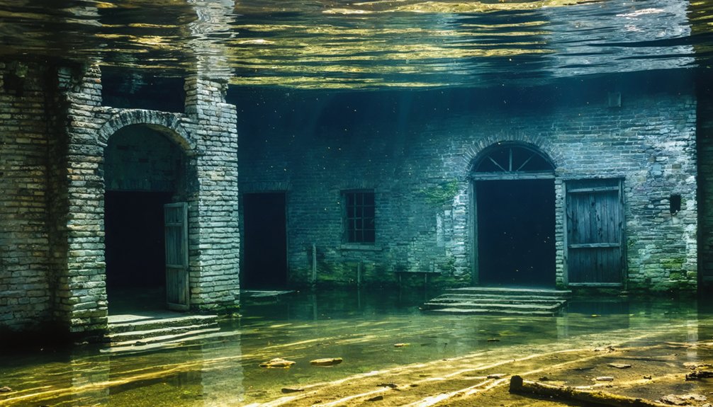
Where the Colorado River once carved through Texas Hill Country, a 19th-century settlement now rests beneath Lake Buchanan’s waters. You’ll find Old Bluffton’s foundations submerged 30 feet down—a stagecoach stop founded in 1853 that housed 50 families with pecan orchards and cotton gins.
When Buchanan Dam’s completion in 1937 brought flood control and electricity, the Lower Colorado River Authority seized properties through eminent domain, forcing residents to relocate.
The lake filled unexpectedly fast from heavy rains, covering buildings before complete dismantling occurred. Excess rainfall exceeding 20 inches in a short period brought the water to capacity within months. Before flooding commenced, the town’s cemetery graves were relocated to prevent submersion. During severe droughts in 2009 and 2011-2013, archaeological preservation efforts by the Texas Historical Commission documented exposed ruins.
Artifact recovery revealed metal tools, medicine bottles, and blacksmith equipment—tangible evidence of frontier life you can explore when water levels drop cyclically during Texas droughts.
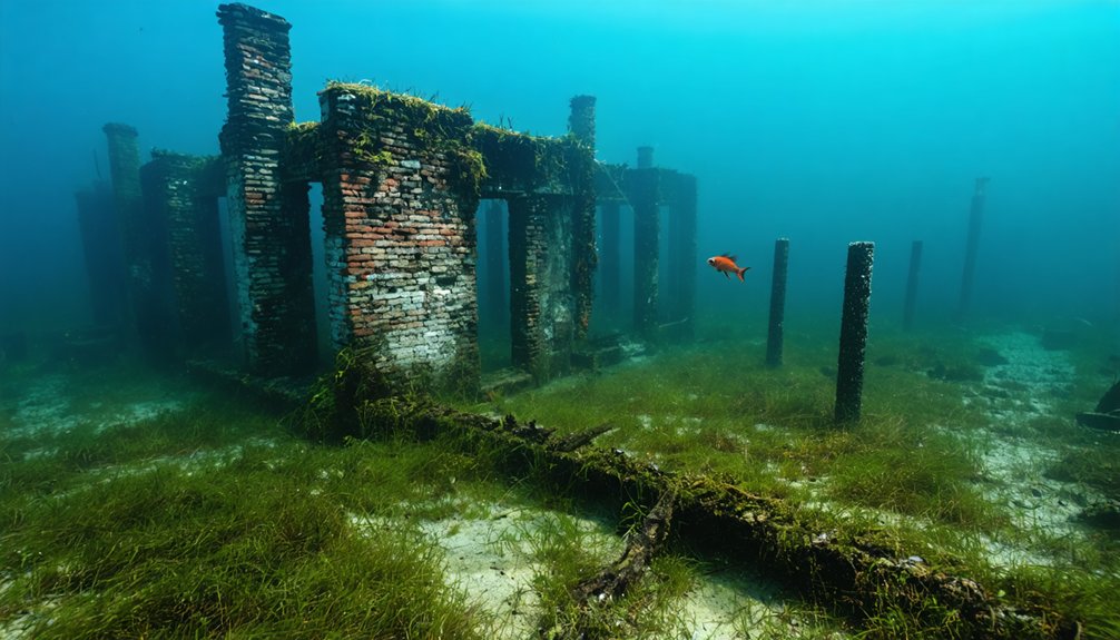
Preston, Cedar Mills, and Woodville: The Lost Communities of Lake Texoma
The Denison Dam project on the Red River created Lake Texoma in 1944, impounding 89,000 acres where the Red and Washita rivers converge—a reservoir that permanently submerged four established Texas communities.
Preston, founded by Holland Coffee as a trading post, served Butterfield Stage Lines and the Shawnee cattle trail before economic decline. The site, originally known as Washita Bend, occupied a strategic location on a prominent bluff above the Red River where Coffee’s trading post served riverboats and barges. Cedar Mills thrived with grist mills and cotton operations, reaching 500 residents by 1884.
Steedman, later renamed Hagerman, housed 150 residents before submersion.
Basin Springs developed around its natural spring along emigrant trails. The spring was described in 1852 as a “fairy bath tub” with clear water pooled in limestone ledges.
The impoundment forced wholesale relocations of railroads, highways, and cemeteries, obliterating these towns’ architectural preservation potential.
While drought conditions in 2011 briefly exposed Cedar Mills gravestones, most cultural heritage evidence remains permanently submerged, accessible only through historical records and displaced families’ memories.
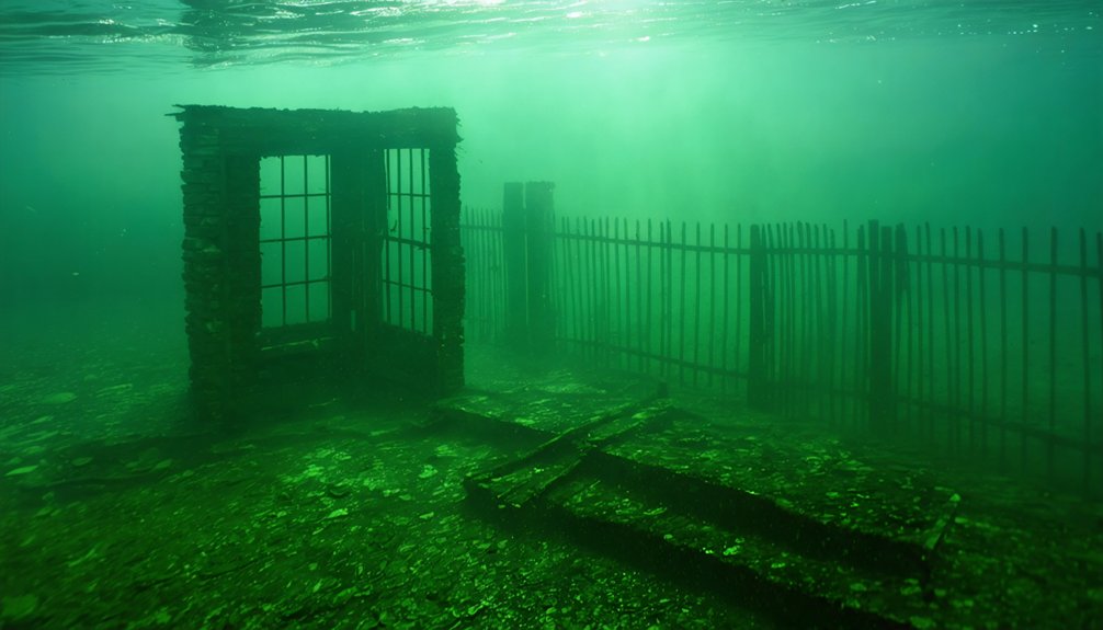
Archaeological Treasures Revealed During Droughts
When Texas droughts drain reservoir levels by over a dozen feet, you gain access to archaeological sites that remain submerged under 30 feet of water during normal conditions.
The 2009 drought enabled Texas Historical Commission excavations at Old Bluffton, where concrete foundations, cotton gin scales, and cemetery tombstones emerged alongside prehistoric artifacts documented across multiple lake systems.
You’re prohibited from removing these discoveries—state marine archaeologists enforce legal protections over underwater sites, having arrested over two dozen looters attempting to scavenge historical materials from exposed locations.
The receding waters have revealed unmarked graves with visible coffin lids in Navarro County, where some remains include those of slaves facing potential disturbance before planned exhumations.
The 2011 drought exposed Cedar Mills gravesite remnants that had been flooded by Lake Texoma, showing how extreme water level drops can temporarily reveal communities lost decades earlier.
Bluffton’s Preserved Historical Artifacts
Beneath Lake Buchanan’s fluctuating waters, an archaeological time capsule has awaited periodic exposure since the town’s 1937 submersion.
You’ll find metal tools, medicine bottles, and blacksmith equipment scattered among submerged homesteads where 50 families once thrived.
School desk fragments and charcoal filtration systems within cisterns document daily life, while cotton gin remains and storm cellars mark commercial enterprise.
The site preserves evidence of underwater agriculture through pecan orchard remnants and cornfield traces.
Drought conditions in 2009 enabled Texas Historical Commission excavations, revealing tombstones, bank foundations, and freed slaves’ graves.
Water coverage at 20-30 feet depth has maintained structural integrity you can’t access elsewhere.
The Lower Colorado River Authority acquired approximately 20,000 acres of land through condemnation and sales to facilitate the dam’s construction.
Guided boat tours from Canyon of the Eagles Lodge transport visitors to these submerged ruins for historical exploration.
Note: removing artifacts from this underwater graveyard violates preservation laws protecting your access to authentic Hill Country heritage.
Lake Texoma Gravestone Exposures
During Lake Texoma’s 2011 summer drought, receding waterlines exposed gravestones from multiple submerged communities across its 93,080-acre impoundment, revealing archaeological evidence that challenged the common assumption that pre-flooding relocations had been thorough.
You’ll find headstones from Woodville, Hagerman, and Cedar Mills emerging when lake levels drop considerably below normal pool elevation. These submerged graves represent physical proof that bodies remained in their original burial sites when the 1944 impoundment created Lake Texoma’s 550-mile shoreline.
The exposure documented cemetery locations from towns like Hagerman (population 150) and Cedar Mills (declined to 50 residents pre-flooding). Local residents often identify these historical gravesite locations using nearby modern landmarks rather than traditional cemetery records.
Woodville’s cemetery at the Washita-Red confluence particularly demonstrates how burial grounds stayed underwater for decades, preserving archaeological sites that authorities never fully excavated before inundation. The region’s significance as part of the Henrietta Focus trade routes made these underwater archaeological sites especially valuable for understanding connections between southwestern and southeastern aboriginal civilizations.
Legal Protection of Discoveries
As drought conditions expose submerged archaeological sites like those at Lake Texoma, Texas’s Antiquities Code of 1969 provides the primary legal framework protecting these discoveries on public lands and waters.
You’ll find the law applies strictly to state-controlled lands, including those managed by river authorities and water districts.
If you discover a shipwreck or submerged site, you’re required to notify the Texas Historical Commission immediately with coordinates while avoiding any disturbance.
However, legal exemptions exist for the vast majority of Texas archaeology—over 90 percent of sites remain under private ownership, where landowners retain full rights to their property’s cultural resources.
You’ll need landowner permission to access private sites, but you won’t face state restrictions on privately-owned archaeological materials.
Indianola: From Thriving Port to Submerged Ruins
You’ll find Indianola’s transformation from Texas’s second-largest port to submerged ruins represents one of the state’s most dramatic coastal losses. The town served as a critical gateway for German immigration and commercial shipping until two catastrophic hurricanes in 1875 and 1886 obliterated its infrastructure and displaced its 5,000 residents.
Today, storm erosion has pushed most of the original townsite underwater in Matagorda Bay, with the 1859 Calhoun County Courthouse now resting 300 feet offshore.
Indianola’s 1800s Port Prominence
When Anglo-American landowners surveyed the site in August 1846, they established Indian Point as a permanent deep-water port on Matagorda Bay in Calhoun County—a strategic location that would transform the settlement into Texas’s second-largest port within three decades.
The 1853 port renovations relocated operations to deeper waters between Matagorda Bay and Powderhorn Bayou, accommodating steamships and enhancing boating safety.
Charles Morgan’s selection of Indianola for his New York-based steamship terminus proved strategic:
- Ships accessed the port via Pass Cavallo within hours
- No hazardous oyster reefs or shallow bars impeded navigation
- Deeper waters eliminated lighter transfers required at competing ports
- Direct steamship service from New York and New Orleans
Twin Hurricanes Devastate Town
On September 15, 1875, a Category 3 hurricane struck Indianola with devastating force, killing between 150 and 300 of the port city’s 5,000 residents and nearly obliterating the town’s infrastructure. Two lighthouse keepers perished as the storm surge swept through.
Over half the population stayed to rebuild, demonstrating remarkable resilience.
However, on August 19-20, 1886, a Category 4 hurricane delivered the final blow. The massive storm surge, accompanied by fire, destroyed everything except two buildings. The railroad washed away completely, eliminating recovery prospects.
County officials relocated the seat inland, and the post office closed October 4, 1887.
Today, underwater ruins mark where the courthouse once stood—now 300 feet offshore in Matagorda Bay. Ghost town preservation efforts designated the site a Recorded Texas Historic Landmark in 1963.
Partial Submersion in Matagorda
Founded as Indian Point in August 1846 on Matagorda Bay’s western shore, Indianola transformed into Texas’s second-largest seaport by the mid-19th century.
Today, shipwreck exploration and underwater archaeology reveal the city’s submerged remains beneath Matagorda Bay.
The original 15-by-4 block town grid now lies almost entirely underwater:
- Courthouse foundations rest 30 feet below the surface
- Crumbling building ruins scatter across the bay floor
- La Salle’s 22-foot granite commemorative statue shifted during Hurricane Carla
- Long wooden wharves remain as deteriorating underwater structures
You’ll find minimal surface evidence—slumping gravestones and a concrete cistern mark what was once a thriving port of 5,000 residents.
The post office’s closure on October 4, 1887, officially declared the city dead, creating Texas’s premier ghost town for underwater archaeology enthusiasts.
Towash and East Texas Towns Under Lake Whitney and Sam Rayburn Reservoir
Long before Lake Whitney’s waters rose to their permanent level in 1951, the settlement of Towash thrived at the mouth of Towash Creek, fifteen miles west of present-day Hillsboro in Hill County. Founded by Ioni Indians in 1835, the community developed substantial infrastructure including a pioneering gristmill built by the Dyer family in 1854.
You’ll find the site’s remains at coordinates 31.922234, -97.343275, where buildings stand intact 110 feet underwater. During the 2011 drought, receding waters exposed wooden foundations and a submerged roadway.
This underwater archaeology offers unique preservation challenges—scuba divers can explore structures, while low lake levels reveal foundations and artifacts like antique bottles and coins along the former shoreline, providing tangible connections to pre-dam settlement patterns.
The Human Cost: Relocations and Infrastructure Changes
Lake Texoma’s 1944 filling demonstrated the massive infrastructure overhauls required:
- Railroads and highways rerouted around rising waters
- Multiple cemeteries excavated and transferred
- Entire utility systems reconstructed
Communities like Preston (360 residents) and Woodville, Oklahoma (360 residents) were completely submerged.
The Sabine River Authority’s meticulous grave transfers preserved family burial layouts, yet community resilience couldn’t prevent the scattering of tight-knit families.
Frequently Asked Questions
Can You Scuba Dive to Visit These Underwater Ghost Towns in Texas?
You can’t legally scuba dive these sites due to historical preservation restrictions and lack of authorized underwater exploration programs. Artifacts removal is prohibited, and no diving permissions exist in available records, limiting your access to drought-exposed periods only.
Are There Other Underwater Ghost Towns in Texas Besides These Mentioned?
Beneath Texas waters lie more submerged secrets. You’ll find additional underwater ghost towns requiring archaeological investigations and historical preservation efforts, though documentation remains incomplete. Exploring these sites demands respecting both regulatory boundaries and our collective heritage’s fragile nature.
How Do Droughts Affect Fish Populations in Lakes Covering Ghost Towns?
Droughts shrink lake habitats, forcing fish migration to deeper pools with lower oxygen levels. You’ll witness ecological consequences including population stress, reduced spawning areas, and concentrated predation—though the background information doesn’t specifically address fish populations in these ghost town lakes.
Were Residents Compensated When Their Towns Were Flooded for Dam Construction?
You’d find governmental decisions employed “land acquisition” policies requiring residents’ departure. Compensation policies varied drastically—Toledo Bend offered $125 per acre, while Lake Belton and others provided inadequate amounts, forcing you to accept whatever authorities deemed sufficient without real choice.
What Happens to Human Remains in Cemeteries That Weren’t Relocated Before Flooding?
Human remains in unrelocated burial sites persist underwater indefinitely without proper preservation. You’ll find the fossilization process doesn’t occur due to insufficient mineralization conditions. Instead, skeletal materials gradually deteriorate in submerged sediments, compromising archaeological and genealogical evidence permanently.
References
- https://www.atlasobscura.com/places/old-bluffton-underwater-ghost-town
- https://www.amli.com/blog/the-underwater-ghost-town-of-bluffton-texas
- https://klaq.com/texas-underwater-cities/
- https://cedarbayoumarina.com/four-ghost-towns-under-lake-texoma/
- https://www.youtube.com/watch?v=x1VRUi_TwoY
- https://www.mapquest.com/travel/underwater-ghost-town/
- https://texashighways.com/culture/history/the-lost-underwater-towns-of-texas/
- http://wideurbanworld.blogspot.com/2012/12/old-bluffton-ghost-town-rises-from-lake.html
- https://101highlandlakes.com/haunted-highland-lakes-old-bluffton-an-underwater-ghost-town/
- https://www.texasobserver.org/bluffton-texas-lost-civilization-rises-from-lake-buchanan/


