You’ll find Iowa’s most haunting autumn scenes where Buckhorn’s weathered creamery stands amid crimson maples, its graffiti-covered walls framing Jackson County’s forgotten streets. When October arrives, Red Rock Lake‘s dropping water levels reveal submerged foundations from six drowned towns, their remnants visible beneath golden reflections. Elkport’s flood-scattered ruins emerge from switchgrass near the Turkey River, while the Driftless Area’s wooded bluffs glow amber around abandoned settlements. The convergence of vibrant foliage and decaying history creates an unforgettable backdrop for those seeking Iowa’s most atmospheric seasonal destinations.
Key Takeaways
- Buckhorn off Highway 64 features a weathered 1899 creamery, whitewashed church, and Civil War cemetery accessible for exterior exploration.
- Elkport’s flood-erased ruins include blacksmith shops, decayed houses, and fractured sidewalks now reclaimed by switchgrass and goldenrod.
- Red Rock Lake’s submerged towns reveal foundations and old roads during low water, best viewed from the mile-long bridge.
- Mid-to-late October offers peak fall colors with crimson sugar maples framing ghost town sites throughout Iowa’s backroads.
- Scenic routes connecting Buckhorn, Effigy Mounds, and Elkport provide ideal dawn-to-dusk trips for foliage and historic exploration.
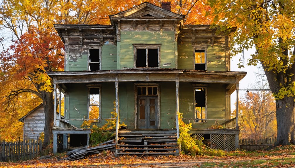
Buckhorn: Jackson County’s Scenic Abandoned Settlement
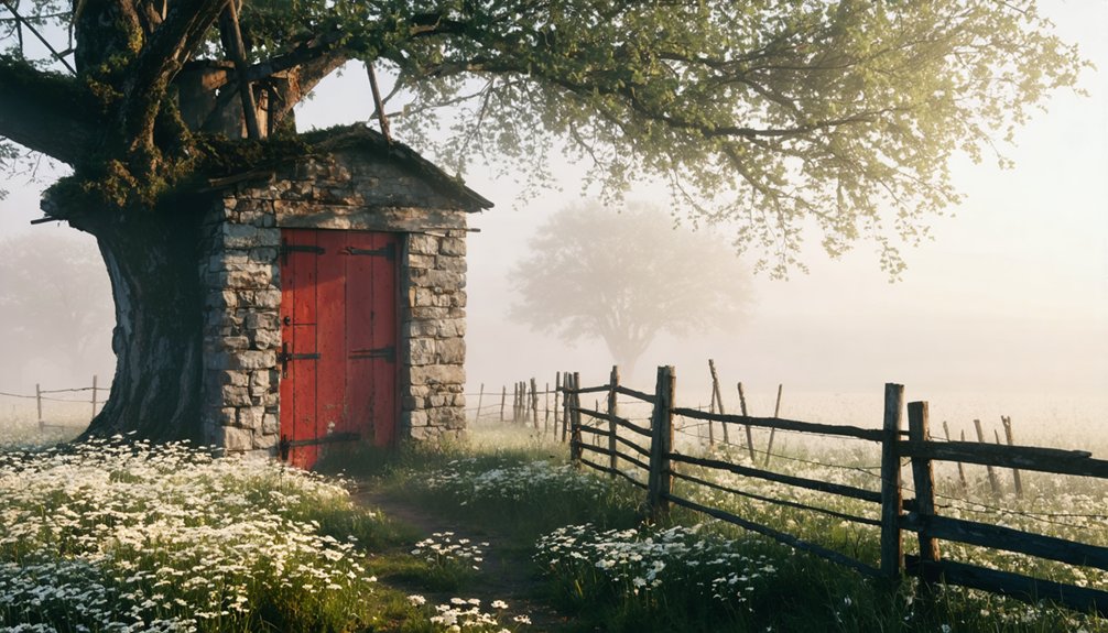
Tucked away in the rolling hills of Jackson County, Buckhorn whispers stories of a vibrant past through its weathered remains. You’ll find this scenic ruin just off Highway 64, where Shadrach Burleson built his settlement in 1836.
The crumbling creamery stands as proof of an era when 700 patrons supplied milk and 34 million pounds of butter flowed from its operations. Graffiti now covers walls where community picnics once drew thousands.
The whitewashed church maintains its dignified exterior, while Buckhorn Cemetery’s Civil War-era headstones rest among the trees. The town’s name originated from antlers mounted at Burleson’s tavern, a detail that still echoes through local history.
Though these historic preserves sit on private property, you’re free to wander the exteriors and imagine autumn leaves painting gold across buildings that once housed a thriving frontier community. The Creamery served as a community hub that distributed dairy products throughout the Midwest.
Elkport and Clayton County’s River Valley Ruins
Where Elk Creek surrenders to the Turkey River, Elkport’s ghost emerges from northeastern Iowa’s fertile valley like a cautionary tale written in water and absence. You’ll find scattered foundations where 88 souls once thrived before 2004’s floodwaters claimed everything they’d built across 150 years.
The federal buyout that followed erased this town so completely that riverbank archaeology now reveals more than memory—crumbling concrete squares hide beneath switchgrass and goldenrod that ignite each autumn. There’s no historic preservation here, just nature reclaiming what the rivers demanded back.
Walk these open fields between the Volga and Turkey convergence, and you’re treading America’s smallest ghost town, where fall colors frame a settlement that learned too late: some locations belong to the water, regardless of human intention. On May 23, 2004, the south-end levee breached, sending more than eight feet of water through homes, the school, and the town’s bank—a deluge that would ultimately force the entire community’s relocation just two years later. Official disincorporation followed in 2005, formally ending Elkport’s 150-year existence as a recognized municipality.
Marion County’s Submerged Towns Beneath Red Rock Lake
You’ll find Iowa’s most haunting ghost towns beneath the rippling surface of Red Rock Lake, where six communities—Coalport, Cordova, Dunreath, Fifield, Red Rock, and Rousseau—vanished underwater when the dam gates closed in 1969.
Standing along the reservoir’s 15,250-acre expanse during autumn, you’re watching crimson and gold leaves drift across water that conceals century-old schoolhouses, sawmills, and coal mining operations that once defined Marion County’s riverside economy.
The surrounding 38,000 acres of public land blaze with fall color each October, transforming this engineered graveyard into a spectacular memorial where nature has reclaimed what flooding first destroyed and progress later preserved.
These settlements emerged between the mid-1800s and early 1900s, with Red Rock being the earliest established in 1842 as a boundary marker for Indian territory known as the Red Rock Line.
The Red Rock Dam’s construction, which began in 1960 and stretched across nine years, was designed to control flooding that had repeatedly devastated these riverside communities since the 1850s.
Towns Lost to Flooding
The waters of Lake Red Rock hold secrets beneath their rippling surface—six entire Iowa towns that once thrived along the Des Moines River before the 1969 dam project sealed their fate.
You’ll find Coalport, Red Rock, Dunreath, Fifield, Cordova, and Rousseau resting in silence below. These weren’t abandoned ruins—they were living communities with schools that’d taught children for over a century, sawmills cutting timber, coal mines fueling river commerce.
When low water reveals Rousseau’s rooftops breaking through the surface, you’re witnessing more than historical shipwrecks of civilization. You’re seeing how floodplain ecosystems reclaimed what humans built. During these conditions, foundations and old roads sometimes emerge, allowing visitors to walk through what were once bustling streets. The town was named in honor of Dr. James Rouso, a prominent physician who served as government land surveyor and laid out multiple Iowa cities before this community met its watery fate.
Red Rock lasted longest, housing 25 families until the final flooding. Now their stories drift in the current, waiting for autumn winds to stir the lake’s memories.
Red Rock Lake History
Long before autumn leaves could settle on its surface, Red Rock Lake swallowed six living towns in a matter of months during 1969—not the gradual, years-long submersion engineers had predicted.
You’re looking at one of those historic dam projects that erased communities like Coalport, Rousseau, and Red Rock—places where blacksmiths hammered, sawmills screamed, and sandstone quarries fed railroad spurs. These weren’t ghost towns yet; families still lived there when bulldozers arrived in 1968.
Submerged town preservation wasn’t the priority—survival was. Residents accepted fair compensation for flood-battered homes without protest, watching crews demolish everything before the gates closed. The drowning of these six towns created Iowa’s largest lake by a significant margin, forever transforming Marion County’s landscape.
Now only foundations remain below, alongside old boxcars chained against erosion. The lake’s surface reflects nothing of the lives beneath.
Fall Foliage Around Reservoir
When October’s palette brushes across Marion County’s wooded bluffs, you’re watching autumn paint over graves—not just metaphorical ones, but six actual towns drowned beneath your feet.
Coalport, Cordova, Dunreath, Fifield, Red Rock, and Rousseau lie submerged under 15,250 acres of water, their stories rising only when the reservoir falls low enough to expose old foundations.
The lake shoreline transforms into a copper-and-crimson gallery each fall, where wooded creeksides along Prairie Creek and Butcher Creek ignite with seasonal fire.
You’ll find the most striking foliage reflections from the mile-long bridge, where autumn’s mirror doubles on still water above drowned streets.
Red Rock itself stood longest, operating a 100-year school until 1958 before the reservoir claimed this settlement that once thrived beside red rock bluffs.
Those same trees root in soil that once echoed with voices, commerce, and floods that eventually convinced entire communities to surrender.
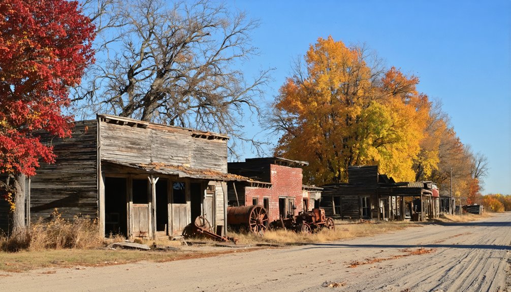
Eastern Iowa Ghost Towns Along the Mississippi River
You’ll find Buckhorn’s weathered church and creamery standing sentinel off Highway 64, their pale facades catching afternoon light while maples blaze orange across the Jackson County hillsides. Drive north into Clayton County, and Elkport emerges from wooded bottomlands—its crumbling foundations half-swallowed by oaks whose crimson leaves carpet the forest floor each October.
These Mississippi River settlements fade into autumn’s embrace, their limestone bones marking where communities once thrived before the waters and decades reclaimed them.
Buckhorn’s Abandoned Riverside Structures
Off Highway 64 in Jackson County, the skeletal remains of Buckhorn’s creamery stand as a monument to agricultural ambition gone silent. Fallen bricks and weathered wood frame graffiti-scarred walls where 34 million pounds of butter once emerged between 1899 and 1952.
You’ll find a whitewashed church nearby, its exterior deceivingly pristine while emptiness echoes within.
The abandoned cemetery crowns a hillside, Civil War-era headstones marking settlers who built this riverside dream.
Without historic preservation efforts or interpretive plaques, local folklore fades with each passing season.
Private property boundaries let you wander exteriors, where autumn leaves collect against crumbling foundations.
That torn chair inside the creamery—visible through broken windows—tells stories of weather, animals, and time’s relentless march through forgotten communities.
Elkport’s Clayton County Ruins
Where Elk Creek surrenders to the Turkey River in Clayton County, Elkport’s ruins sprawl across floodplains that claimed everything in a single May afternoon. You’ll find foundations jutting through prairie grass where 88 residents once called home before 2004’s devastating breach sent ten feet of water through their levee.
The historical preservation here isn’t museum-quality—it’s raw, unfiltered abandonment. A bug-infested church stands defiant on higher ground, its weathered walls testament to environmental impact that forced complete disincorporation by 2005.
Walk the fractured sidewalks between blacksmith shops and decay-hollowed houses, where federal buyouts transformed a 150-year community into agricultural fields. These aren’t prettified ruins—they’re honest scars where nature reclaimed what rivers always owned.
Planning Your Autumn Ghost Town Road Trip
The Driftless Area of Northeast Iowa unfolds like a watercolor painting in autumn, where amber ridges cascade into valleys sheltering forgotten settlements frozen in time. You’ll want to chart your course from Marquette’s scenic overlook down through Effigy Mounds, threading back roads to Elkport’s crumbling facades and Littleport’s weathered bones.
Mid-to-late October delivers peak colors—sugar maples blazing crimson against limestone bluffs while you explore Conover near Phelps Park or Buckhorn off Highway 64. Pack hiking boots for Backbone State Park’s trails, layers for crisp October mornings, and binoculars for distant vistas.
Sturdy shoes matter on uneven ghost town terrain. Monitor weekly foliage reports, carry water for remote stretches through Yellow River State Forest, and leave dawn-to-dusk for maximum exploration.
Haunted Histories That Complement Your Foliage Tour
Beyond amber ridges and crimson maples, Iowa’s backroads harbor darker stories that’ll send shivers down your spine while you chase autumn colors. The Villisca Axe Murder House stands frozen in 1912, where eight souls met brutal ends—you’ll find lights flickering at your command and cold spots materializing between rooms.
Oakland Cemetery’s Black Angel towers 8.5 feet high, her oxidized copper casting shadows through October’s fading light. Haunted legends swirl around midnight touches and seven-year curses.
At Periwinkle Place Manor, paranormal artifacts captured on video reveal a little girl’s games echoing through the former funeral home.
Granger House’s woman in white materializes at midnight windows, while Buckhorn’s deserted creamery buildings stand sentinel amid Jackson County’s painted forests, waiting for your flashlight beam.
Frequently Asked Questions
Are Iowa Ghost Towns on Private Property or Accessible Year-Round?
Many Iowa ghost towns sit on private property, but you’ll find year-round access at public sites like Elkport and Buckhorn. Historical preservation efforts have opened select remnants, though private property access requires permission before exploring these hauntingly beautiful ruins.
What Camera Equipment Works Best for Photographing Abandoned Buildings in Autumn?
You’ll want wide-angle camera lenses like a 16-35mm to capture autumn’s golden light filtering through broken windows, plus essential protective gear—sturdy gloves and a mask shield you from crumbling debris while you’re exploring Iowa’s forgotten spaces.
Can You Camp Overnight Near Ghost Town Sites During Fall?
You’ll find few formal campgrounds flanking ghost towns, but you’re free to book haunted legends accommodations nearby—like Villisca’s murder house—where scenic viewpoints meet spine-tingling folklore through amber autumn leaves and crumbling structures.
Do Any Ghost Towns Have Guided Tours During Peak Foliage Season?
No true ghost towns offer guided tours during peak foliage season. You’ll find seasonal events at preserved sites like Villisca Axe Murder House, where historical preservation meets paranormal intrigue, but authentic abandoned towns remain wild, unstructured explorations through autumn’s golden embrace.
Are There Safety Concerns When Exploring Abandoned Structures in Rural Areas?
Yes, you’ll face serious risks including structural instability from rotting beams and collapsing roofs, plus legal consequences from unauthorized access on private property. Crumbling walls, toxic mold, wildlife encounters, and hidden hazards make exploration genuinely dangerous without permission.
References
- https://www.traveliowa.com/10-must-visit-fall-attractions/
- https://www.thegazette.com/travel/a-day-away-plan-a-haunted-iowa-road-trip-to-these-spirited-sites/
- https://en.wikipedia.org/wiki/List_of_ghost_towns_in_Iowa
- https://krna.com/abandoned-iowa-buckhorn/
- http://www.iowapbs.org/article/8600/local-legends-around-iowas-haunted-locations
- http://www.onlyinyourstate.com/experiences/iowa/ia-ghost-town
- https://www.unleashcb.com/blog/fall_foliage_in_pottawattamie_county
- https://www.youtube.com/watch?v=GGspKT8w108
- https://khak.com/abandoned-attraction-ghost-town-buckhorn-iowa/
- https://www.youtube.com/watch?v=1J0Qx64ZrwI