You’ll find Missouri’s most atmospheric ghost towns along Route 66 and Ozark backroads during October’s brief color peak. Halltown’s boarded-up storefronts and 1923 bridge frame scarlet oaks thirteen miles west of Springfield, while Monark Spring’s abandoned structures near Neosho reflect amber hues across floodplain ruins. The Glade Top Trail winds past overgrown foundations where yellow hickories and orange maples reclaim settler history. Devil’s Elbow offers waterside exploration of abandoned establishments beneath crimson bluffs, and the route from Versailles to Ha Ha Tonka’s castle ruins reveals multiple forgotten settlements.
Key Takeaways
- Halltown, 13 miles west of Springfield, features boarded-up Route 66 shops and stone buildings framed by vibrant autumn foliage.
- Monark Spring near Neosho displays abandoned structures and a 1940 Tabernacle surrounded by floodplain fall colors and scenic remnants.
- Glade Top Trail winds 23 miles through overgrown foundations and settler ruins amid scarlet oaks, hickories, and maple displays.
- Arlington, Possum Trot, and Radical along Highway 5 are abandoned settlements now reclaimed by colorful scarlet oak forests.
- October offers peak fall foliage viewing at Missouri ghost towns, with early November also favorable depending on weather conditions.
Rosati’s Living Legacy Among Vineyards and Autumn Colors
When autumn paints the Ozark hills in copper and gold, Rosati’s vineyards transform into something almost too picturesque for a place that’s technically fading from the map.
Rosati’s autumn vineyards glow impossibly beautiful for a community slowly disappearing from Missouri’s maps and memory.
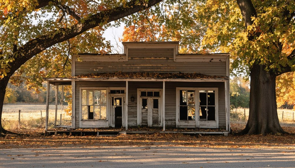
You’ll find this unincorporated community straddling the Phelps-Crawford county line, where Italian immigrants from the Cottian Alps planted their dreams in 1898. Their vineyard heritage still breathes along old Route 66, though the highway abandoned them in the 1950s.
The grapevines they established—first struggling European varieties, then thriving Concords, finally proper wine grapes in the 1970s—blaze crimson against weathered fence posts each fall.
St. Anthony Catholic Church still anchors the community, but you’re mostly visiting for those autumn vineyards rolling toward distant knobs that gave this place its original name: Knobview, before Bishop Rosati claimed it posthumously. The town’s early prosperity came from the railroad’s influence, which helped establish the community before Route 66 ever arrived. The Cardetti & Sons Mercantile served multiple roles as store, school, and post office until the landmark building finally closed in 2014.
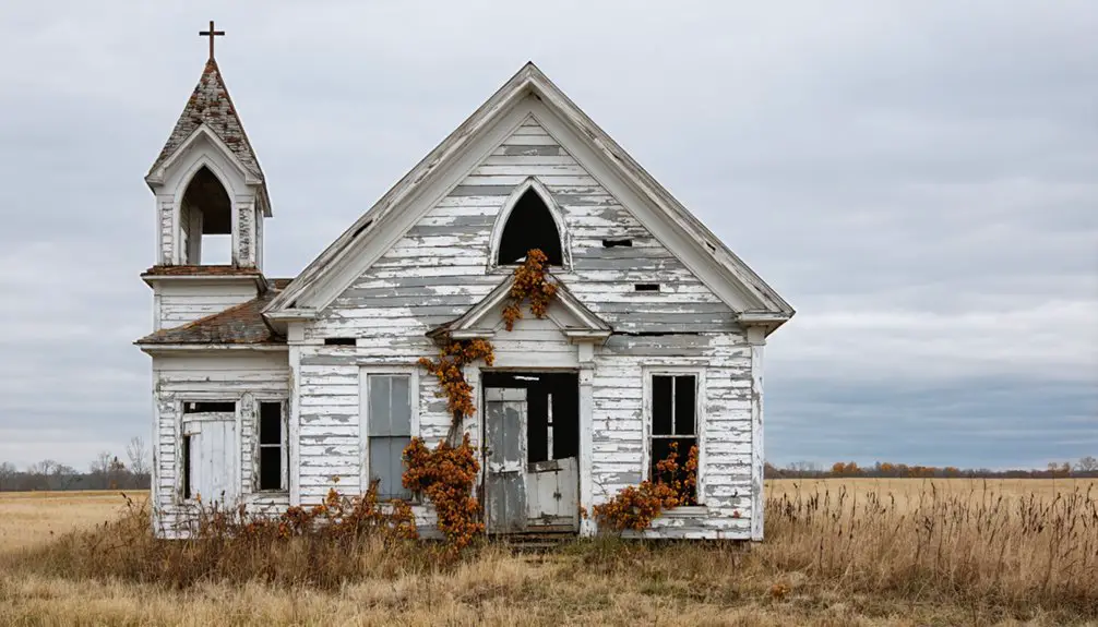
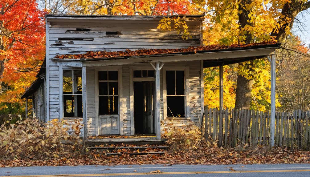
Halltown’s Route 66 Antique District in Peak Foliage Season
You’ll cruise down the old Route 66 alignment through Halltown just as the sugar maples ignite into flame-orange crowns above weathered antique storefronts.
The historic district’s boarded-up shops and stone buildings create a photographer’s dream when framed by October’s golden light filtering through the canopy. The 1923 Halltown Bridge, a riveted Pratt Pony Truss spanning Billies Creek, offers an ideal vantage point for capturing the convergence of engineering history and seasonal color.
This strip of forgotten America transforms each autumn into a living postcard where vintage Route 66 signs pierce through layers of crimson and amber leaves. The Halltown Christian Church and Hall Town Baptist Church stand as sentinel landmarks, their old bells framed by autumn foliage along the narrow main street.
Antique Shops Among Maples
Thirteen miles west of Springfield, where Route 66 curves through Lawrence County at 1,168 feet elevation, Halltown’s antique shops stand beneath crimson maples like relics frozen in amber.
You’ll find the Halltown RT 66 Antique Mall still breathing life into this ghost town, its vintage charm amplified when October transforms the streetscape into a corridor of rust and gold.
Maple reflections dance across weathered storefronts—the old Whitehall Mercantile, stone warehouses from 1906, boarded-up cafes that once fed travelers on their westward migrations.
This was the “Antique Capital of the U.S.,” where dealers hawked Depression glass and Dust Bowl memories while leaves spiraled past gas pumps.
The two-story limestone structure from 1907 once projected silent films for travelers, its arched windows now framing only autumn’s fleeting show.
Walk Main Street now. Route 66 arrived in 1927, boosting cafes and roadside services that now stand silent beneath the turning leaves. The maples remain faithful witnesses, dropping their brilliant currency where commerce once thrived.
Route 66 Autumn Drive
As mid-October arrives, Route 66 through Halltown becomes a tunnel of fire—crimson maples arching overhead, golden hickories flanking the weathered pavement, rust-colored oaks standing sentinel behind abandoned storefronts.
You’ll find history preservation woven into every faded sign and vintage gas pump, now framed by nature’s rebellion against concrete.
The Ozark hills provide scenic viewpoints where ash trees blaze orange against forgotten billboards.
Pull over at the antique district when morning light hits—that’s when dew-covered Virginia creeper glows deepest scarlet on crumbling brick walls.
This seven-to-ten-day window demands timing, but warm afternoons and crisp nights typically hold the display through early November.
Drive slowly.
The Mother Road’s ghosts share space with sumac and sycamores now, creating something museums can’t replicate—freedom wrapped in autumn gold.
Wind and heavy rain can cut the show short, so check forecasts before making the drive.
Even the prairie remnants along the highway shoulders add unexpected bursts of copper and burgundy to the abandoned landscape.
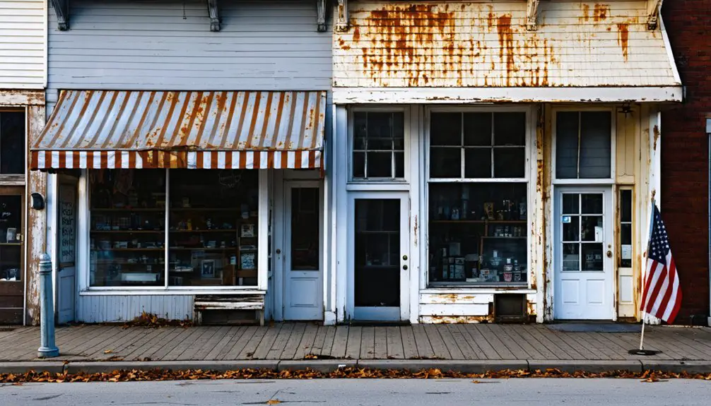
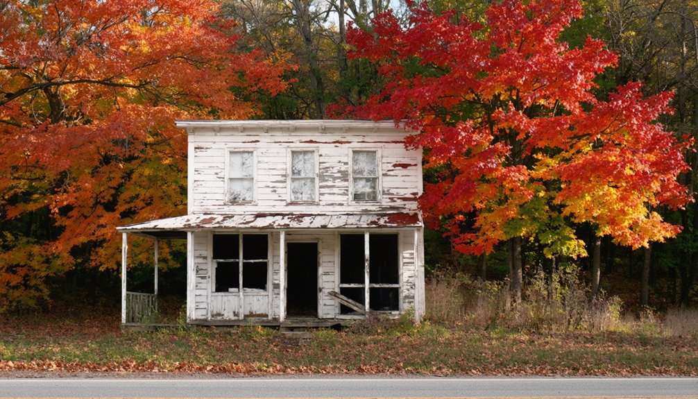
Historic Storefronts Frame Fall
Between Springfield and the Kansas border, Halltown’s weathered storefronts stand like stage sets for October’s performance. You’ll find the 1900 Whitehall Mercantile‘s Victorian façade dressed in crimson vines, while the Mission-style Las Vegas Hotel’s stucco walls glow amber against scarlet maples.
The 1907 two-story stone building anchors Main Street like a monument to forgotten prosperity, its solid rock construction framing perfect fall photography opportunities.
These boarded-up establishments that once numbered over twenty in 1946 now serve as canvas for autumn’s palette. The historic architecture tells stories through peeling paint and empty windows—seven antique shops reduced to memories. The last antique shop closed in 2016, marking the end of the town’s identity as “The Antique Capital of the U.S.”
You’ll discover Springfield commuters’ cars parked near operational storefronts, creating unexpected contrast between abandonment and persistence, all bathed in fall’s golden hour light. This tiny 0.2 square mile area packs remarkable history into an impossibly compact footprint, making it perfect for a quick autumn walk.
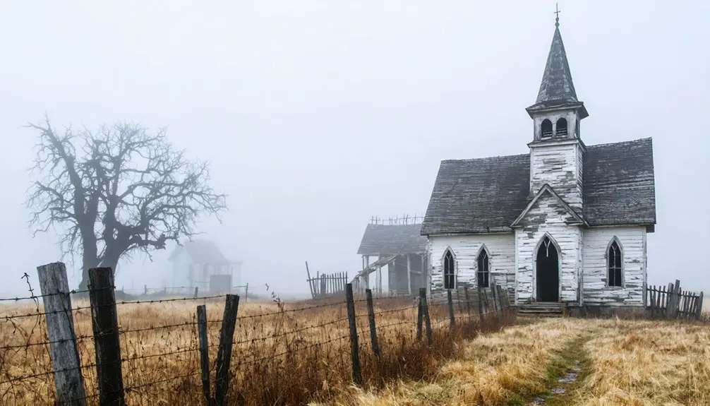
Monark Spring’s Fields and Memories Beneath Fall Skies
Where hickory trees once shaded singing pilgrims arriving by rail car, autumn now paints the floodplain in amber and rust, reclaiming what MoNArk Springs left behind.
You’ll find this ghost town five miles east of Neosho, where Brother John Stretch’s 1940 tabernacle once welcomed hundreds to Church of God gatherings.
The 1956 typhoid outbreak silenced those hymns forever—contaminated well water sent sixteen ill, scattering a community that had thrived since Truman Elmore’s founding.
Today, autumn reflections dance across Hickory Creek where 500 feet from the spring, you’ll discover scattered remains: a possible schoolhouse, one surviving home, a community center preserving history through painted scenes of 1905.
Despite darkness in its past, you’re free to wander these fields where faith and tragedy intertwined beneath Missouri skies.
Exploring Abandoned Settlements Along the Glade Top Trail
Built by Civilian Conservation Corps hands in the late 1930s, Glade Top Trail unspools for twenty-three miles through Mark Twain National Forest like a ribbon of gravel suspended above time itself.
You’ll climb five hundred feet above the rolling White River Hills, passing abandoned ruins hidden beneath October’s copper and gold canopy.
Pull over at seven overlooks where Arkansas’s Boston Mountains shimmer forty miles south, then venture onto overgrown foundations where settlers once carved lives from limestone glades.
The narrow ridge top reveals kaleidoscopic vistas—scarlet oaks, yellow hickories, orange maples blazing against weathered stone walls.
Stop at Caney Day Use Area’s natural cave, or contemplate the silent Caney Fire Tower standing sentinel since CCC days.
This all-weather route delivers freedom without pavement’s constraints, autumn without crowds.
Devil’s Elbow and Ozark River Towns During Autumn Float Trips
From ridge-top overlooks, you’ve traced the contours of abandoned homesteads; now follow those same ridges downward where the Big Piney River carves through Ozark limestone in serpentine curves.
Devil’s Elbow wraps around you in three directions, its 1923 steel bridge spanning waters that challenged lumberjacks’ river navigation since 1816.
Launch from Schlicht Springs in October when amber maples frame moss-covered boulders emerging from lowered currents.
The hamlet itself qualifies as semi-ghost—population fifteen—with flood-ravaged buildings earning National Register status.
Historic landmarks punctuate your float: Hiawatha Bluffs towering overhead, remnants of Devil’s Elbow Cafe, the shuttered Elbow Inn awaiting restoration.
Paddle past freshwater springs bursting from limestone banks while autumn’s crimson and gold reflect off class II riffles, each bend revealing why rowdy lumbermen cursed this beautiful, unforgiving passage.
Planning Your Ghost Town and Foliage Tour Through the Ozarks
How do you capture both architectural decay and nature’s brief brilliance in a single October journey? Start your loop in Versailles, following Highway 5 south where amber hillsides frame forgotten settlements like Arlington in Phelps County.
Where weathered homesteads meet October’s amber hillsides, Highway 5 threads through Phelps County’s fading settlements and autumn’s fleeting fire.
You’ll wind through geological formations that once drew miners to Possum Trot and Radical—Stone County relics now reclaimed by scarlet oaks.
At Ha Ha Tonka, descend 316 wooden steps where Native traditions once honored the great spring, now overlooked by castle ruins against crimson bluffs.
Continue to Alley Mill via Highway 106, where Eminence’s pines blaze orange around the red structure.
Pack hiking boots for Dell Rim Trail‘s sinkholes, and avoid rigid schedules—autumn’s palette shifts with every cold front sweeping these untamed ridges.
Frequently Asked Questions
What Safety Precautions Should Visitors Take When Exploring Abandoned Ghost Town Structures?
You’ll absolutely need industrial-grade safety gear—sturdy boots, helmets, respirators—before attempting urban exploration. Test every floorboard like it’s concealing quicksand, watch for crumbling walls, avoid wildlife dens, and you’ll conquer these decaying monuments to freedom.
Are the Vineyards in Rosati Open to Public Wine Tastings Year-Round?
You’ll find Rosati Winery Museum offers year-round complimentary tastings, though it’s not a working vineyard. For authentic vineyard tours and seasonal wine tastings, you’ll want to explore nearby St. James Winery or Peaceful Bend instead.
Which Ghost Towns Require Special Permits or Permissions to Access Legally?
You’ll need EPA approval for Times Beach’s hidden history and DOE permits for Weldon Spring’s contaminated ruins—access regulations keep these toxic ghost towns locked tight. Ha Ha Tonka’s castle? Freely yours to explore without bureaucratic hassle.
What Photography Equipment Works Best for Capturing Ghost Towns in Autumn Light?
You’ll want a wide-angle lens like the Sony 16-35mm f/4 to capture expansive autumn lighting across abandoned structures. Camera settings around f/8 with low ISO let you shoot handheld, preserving those golden-hour textures and weathered details beautifully.
Can Visitors Camp Overnight Near Any of Missouri’s Ghost Town Locations?
You can’t camp directly at Missouri’s ghost towns due to historic preservation restrictions and safety concerns. For urban exploration adventures, you’ll find nearby state parks offering campgrounds within driving distance of abandoned sites you’re seeking.
References
- https://www.417mag.com/lifestyle/best-fall-activities-southwest-missouri/
- https://www.ozarksalive.com/stories/six-places-to-see-fabulous-fall-foliage
- https://en.wikipedia.org/wiki/List_of_ghost_towns_in_Missouri
- https://www.youtube.com/watch?v=eXBMX4O1-pQ
- https://www.aol.com/articles/escape-charming-mountain-towns-missouri-014005092.html
- https://979kickfm.com/best-fall-foliage-missouri/
- https://www.youtube.com/watch?v=qu3r4Vf6fG4
- https://www.theroute-66.com/rosati.html
- https://ozarks-history.blogspot.com/2012/11/rosatiknobview.html
- https://italianenclaves.org/2025/04/04/a-look-at-missouri-enclaves-rosati-colombus-park-and-monett/