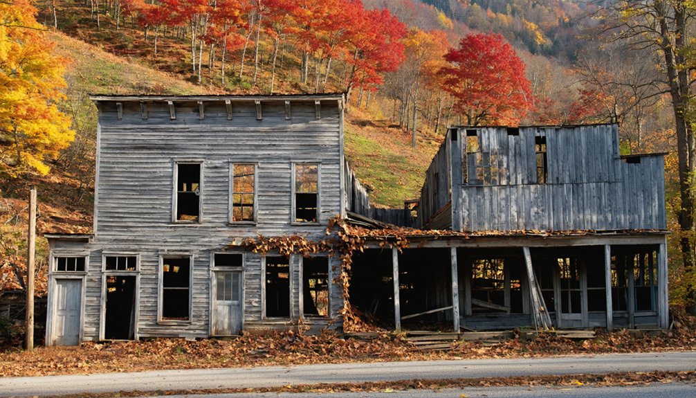
You’ll find Virginia’s ghost towns dramatically framed by autumn’s crimson and gold along the Blue Ridge Parkway, where abandoned mining settlements like those in Floyd County emerge from maple-covered hillsides. Matildaville’s 1785 canal ruins rest beside the Potomac under scarlet canopies, while Prince William Forest Park conceals three displaced communities—Joplin, Hickory Ridge, and Batetown—beneath hardwood forests ablaze with October color. Route 7’s corridor reveals forgotten farmsteads and stone foundations wrapped in vibrant foliage, and Thornrose Cemetery‘s weathered monuments stand among falling leaves, each site offering layered stories of ambition, displacement, and nature’s persistent reclamation.
Key Takeaways
- Matildaville on the Potomac River features ruins of an 1785 company town, with mill and foundry remnants amid autumn colors.
- Prince William Forest Park contains abandoned communities like Joplin and Batewood, with concrete ruins and 45 family cemeteries reclaimed by forest.
- Floyd County mining towns showcase copper and gold prospect remnants along Blue Ridge Parkway, with Mabry Mill displaying rural decay.
- Wash Woods Ghost Town preserves shipwreck survivor ruins, while Old House Woods features skeletal pines and marshes along coastal Virginia.
- Best foliage viewing occurs October 21–November 4, with trails connecting to historic ruins and scenic overlooks throughout mountain regions.
Matildaville: George Washington’s Forgotten Dream Along the Potomac
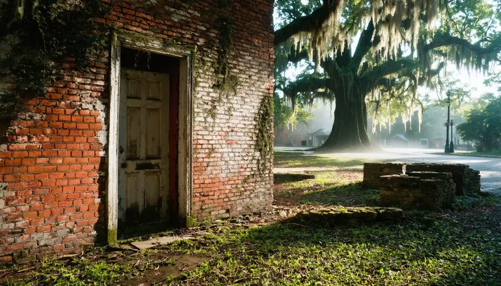
Along the banks of the Potomac River, where autumn leaves now blanket crumbling stone foundations, lies Matildaville—a ghost town born from George Washington’s ambitious vision to unite a fledgling nation through waterways.
You’ll discover remnants of what was once headquarters for the Patowmack Company’s groundbreaking canal engineering project, established in 1785 to link the Potomac and Ohio rivers.
Named after Matilda Lee in 1793, this settlement flourished with mills, foundries, and an inn serving canal workers and travelers.
Though the innovative locks completed in 1802 pioneered historic preservation-worthy techniques, financial troubles doomed the venture.
The company collected $172,689.39 in tolls by 1818 but had spent over $650,000 on construction, creating unsustainable debt that forced closure.
By 1830, the bypassed town emptied.
The Dickey family maintained a presence here for nearly 200 years, operating Dickeys Tavern as a hospitality center that welcomed guests from George Washington to Theodore Roosevelt until about 1935.
Today, you can explore these ruins via Matildaville Trail in Great Falls Park, where nature reclaims Washington’s unfulfilled dream of continental commerce.
LOVETTSVILLE Area: Civil War Remnants in Loudoun County Hills
You’ll find Lovettsville’s historic core easily accessible from Route 7, nestled in the rolling hills just 50 miles northwest of Washington, D.C.
Time your visit for mid-to-late October when the Blue Ridge foothills blaze with crimson and gold, transforming the streets where Union and Confederate forces once marched.
Base yourself in nearby Leesburg, where modern amenities meet colonial charm, then venture into these northern Loudoun hills where Civil War-era buildings still stand beneath autumn’s canopy. The community’s German immigrant settlers from the late 1700s left their mark in over a dozen pre-Civil War residences visible from the public right-of-way. A half-mile walking trail connects three interpretive signs that chronicle the town’s experiences from 1861 through the Union cavalry occupation of 1865.
Route 7 Corridor Access
West of Leesburg, the Route 7 corridor cuts through Loudoun County’s rolling hills toward Lovettsville, where German settlers carved out a fiercely Unionist enclave in Confederate Virginia. You’ll follow the same route Union and Confederate forces marched between 1861 and 1865, when this community’s German heritage shaped its defiant loyalty to the Union.
The 40-minute drive from Washington delivers you to 90 acres of preserved history—111 properties spanning Federal townhouses to Craftsman bungalows, three churches standing witness to conscience over conformity, and five cemeteries where German gravestones mark those who chose principle over popular allegiance.
Park along East Pennsylvania Avenue and trace the half-mile Civil War Trails walking tour, where interpretive signs reveal how this small town resisted Confederate pressure while armies tramped through their streets. The walking tour depicts different phases of the war from 1861 to 1865, blending signage into the historic district to tell the evolving story of this community’s wartime experience. The town’s roots reach back to 1732, when the first German families founded what would become Lovettsville, establishing a settlement contemporary with George Washington’s birth.
Peak Foliage Timing October
When October settles over Lovettsville’s German-founded streets, the surrounding Loudoun County hills ignite in waves of crimson maples and golden oaks that frame Civil War-era architecture in nature’s most theatrical backdrop.
You’ll find peak colors blazing between October 10 and 31, with the most intense displays occurring mid-month when cool nights trigger anthocyanin production in sweetgums and hickories.
Foliage photo tips: Chase the sunrise at Bear’s Den for west-facing views where morning light sets the Shenandoah Valley canopy ablaze. Recent rainfall intensifies color saturation across elevations, while autumn wildlife—migrating warblers and white-tailed deer—adds movement to your compositions. The cooler nights and mornings will continue to accelerate the color change process throughout the region.
Higher Blue Ridge elevations peak first, creating a two-week window as vibrant reds cascade downward through historic stone walls and abandoned Civil War encampments dotting these freedom-soaked hills. Below-normal precipitation contributes to particularly vivid leaf colors this season, making the contrast against weathered Civil War monuments even more striking.
Leesburg Base for Exploration
From Leesburg’s brick-lined streets, you’re positioned at the gateway to Loudoun County’s most conflicted Civil War landscape, where German-founded Lovettsville stands as a Union island in Confederate territory.
This 2.5-mile journey north reveals a settlement that defied Virginia’s secession, where Pennsylvania Dutch farmers chose conscience over conformity. You’ll discover three Civil War Trails markers threading through 90 acres of historic district—111 properties documenting 1730s German roots and 1860s occupation.
The Lovettsville Historical Society Museum illuminates stories of harassment and resistance, while five cemeteries hold witnesses to divided loyalties. The town’s modified grid pattern connects East Pennsylvania Avenue, East Broad Way, and South Loudoun Street through smaller perpendicular roads that once channeled both Union and Confederate movements.
German heritage festivals celebrate the immigrants who arrived in 1732, and Civil War reenactments resurrect October 1862’s tensions when Union and Confederate forces collided along these contested roads.
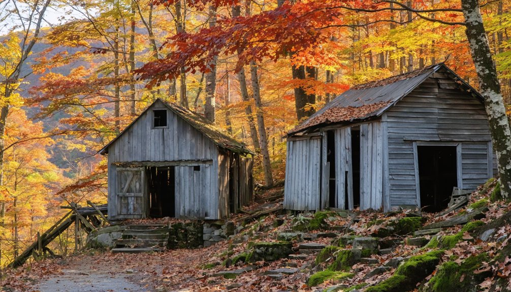
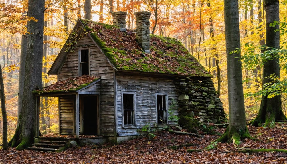
Prince William Forest Park: Hidden Settlements Beneath Autumn Canopy
You’ll discover three vanished communities—Joplin, Hickory Ridge, and Batestown—hidden beneath 16,000 acres of blazing October maples and golden hickories. Their stories are etched in 45 family cemeteries scattered throughout the forest.
The park’s scenic drives and branch-trail loops guide you past crumbling foundations and forgotten graveyards where Revolutionary War veterans and former pyrite miners rest. Peak color typically arrives mid-to-late October along routes like Scenic Drive and Birch Bluff Trail. The ruins of the old pyrite mine, operational from 1889 to 1920, once supported a company town of approximately 70 buildings whose cement foundations still dot the forest floor.
Trek the eastern Batestown Road area, where freed slaves built a thriving 150-person settlement, now reclaimed by autumn’s crimson canopy. Or explore North Orenda Road, where cemetery visitors still leave fresh flowers among the fallen leaves.
Abandoned Town Ruins Explored
Beneath the crimson and gold canopy of Prince William Forest Park, moss-covered foundations whisper stories of three vanished communities that thrived here for generations. You’ll discover remnants of Joplin, Hickory Ridge, and Batestown—settlements erased by federal displacement between 1933-1937.
Unlike typical urban decay in ghost towns, these weren’t abandoned by choice. The Resettlement Administration condemned 127 properties, forcing out 150 families who’d built lives around the Cabin Branch Pyrite Mine.
Trek the Cabin Branch Mine Trail northwest of the Visitor’s Center to find concrete ruins reclaimed by forest. Forty-five family cemeteries dot the landscape, though fewer than twelve appear on official maps.
Revolutionary War veteran Luke Cannon rests somewhere beneath autumn leaves, his grave marking freedoms won and lost.
Peak Foliage Timing Guide
The vanished settlements of Prince William Forest Park reveal their greatest beauty when autumn ignites the canopy above their crumbling foundations.
You’ll find peak colors transforming these 15,000 wooded acres between October 21st and November 4th, though dry September weather can advance the timeline.
Black gum trees blaze crimson red first, followed by sugar maples erupting in brilliant orange across the piedmont forest.
Plan your seasonal hikes for weekdays when 37 miles of trails stay quiet and foliage photography captures golds, ambers, and russets without crowds.
Monitor real-time reports through Virginia Tourism’s fall pages, since strong winds or heavy rains can strip colors overnight.
The park’s oak-dominated forests hold their deep amber hues longest, giving you flexibility as weather shifts throughout the season.
Scenic Loop Trail Options
When October’s palette sweeps across Prince William Forest Park, five interconnected trail loops guide you past abandoned homesteads and forgotten settlements cloaked in brilliant foliage.
The 2.2-mile Birch Bluff Laurel Loop delivers easy wildlife viewing along South Fork Quantico Creek‘s sandy banks, where cascades tumble through rust-colored leaves.
For deeper exploration, tackle the 7.4-mile South Valley Trail Loop through hardwood forests ablaze with color, connecting via orange-blazed High Meadows Trail past a small cemetery hidden beneath golden canopy.
Turkey Run Ridge Trail’s blue blazes wind through crimson undergrowth, while consistent trail maintenance keeps 35 miles of pathways accessible.
Navigate by color-coded markers—red, yellow, orange, white, blue—as you discover concrete foundations and stone walls emerging from autumn’s copper-toned forest floor.
Thornrose Cemetery in Staunton: Where History Rests Among October Colors
Crimson maples and golden oaks frame weathered limestone monuments at Thornrose Cemetery, where Staunton’s history unfolds beneath October’s painted canopy.
Autumn’s vibrant palette illuminates centuries of Staunton’s past among Thornrose Cemetery’s weathered stones and storied grounds.
You’ll discover T.J. Collins’s 1896 limestone gatehouse standing sentinel over thirty acres of cemetery architecture, from ornate mausoleums to the haunting “Staunton Mourning Her Dead” marble statue.
Historical preservation efforts maintain this 1849 sanctuary where 1,800 Confederate soldiers rest in unmarked graves alongside notable Virginians.
Walk past the granite mausoleum’s four seasons statues as autumn leaves crunch underfoot, exploring walkways that’ve witnessed processions since Professor McGuffey’s dedication speech in 1853.
The stone bridge and tower create a photographer’s paradise when fall transforms this “city of the dead” into nature’s masterpiece.
Blue Ridge Parkway: Ravens Roost and Abandoned Mining Communities
At 3,200 feet above sea level, Ravens Roost Overlook commands a breathtaking 180-degree panorama where autumn sets the Shenandoah Valley ablaze in crimson and gold.
You’ll find this gem at Milepost 10.7 on Blue Ridge Parkway, where misty mornings reveal the ghostly 40-foot Torrey Furnace ruins below—a pre-Civil War iron foundry that once forged pig iron until the 1880s.
The scenic overlooks here tell stories of abandoned industry against nature’s seasonal spectacle.
Navigate the rocky path to the cliff’s edge where ravens roost and rock climbers rappel.
Time your visit for sunrise when fog lifts from valleys below, exposing rolling ridges painted in burgundy and amber.
This Virginia Historic Landmark stands as *testament* to forgotten mountain communities.
Grayson Highlands: Alpine Ghost Hamlets Above the Clouds
At 5,000 feet above sea level, you’ll discover the remnants of forgotten settlements where early pioneers like the Massey family once carved out lives among windswept balds and rocky outcroppings.
The 1.6-mile Twin Pinnacles loop carries you through birch groves and spruce stands blazing with autumn color, past stone foundations and overgrown homestead traces that mark these alpine ghost hamlets.
From Massie Gap’s elevated meadows, wild ponies graze where settlers’ cabins once stood, and the fall foliage stretches endlessly below—a tapestry of crimson and gold framed by the volcanic peaks of Mount Rogers and Whitetop Mountain.
High-Elevation Mining Town Ruins
Perched above 5,000 feet where Virginia’s sky meets Appalachian stone, Grayson Highlands harbors the skeletal remains of forgotten mining settlements that once thrived in conditions most would consider uninhabitable. These high-altitude ruins tell stories of miners who extracted iron ore and manganese from mountain peaks, enduring winters that could kill unprepared souls.
September transforms this harsh landscape into something breathtaking:
- Mining relics emerge from crimson blueberry thickets that carpet the balds.
- Stone foundations stand against golden grasses bending in relentless winds.
- Rusted equipment frames flame-orange mountain ash berries.
- Frost arrives by mid-month, intensifying leaf colors overnight.
- Wild ponies graze among cabin ruins, descendants of pack animals.
You’ll find freedom in these exposed heights where civilization attempted—and ultimately surrendered to—nature’s sovereignty.
Wild Pony Overlook Views
Where Virginia’s highest balds sweep toward Tennessee, wild ponies materialize through autumn mist like apparitions from another century—descendants of the working animals that once served mining camps now reduced to moss-covered stone. You’ll find approximately 150 of these creatures roaming Grayson Highlands’ 5,000-foot peaks.
Their silhouettes are stark against flame-orange maples and crimson oaks. The Rhododendron Trail delivers wild pony sightings within a half-mile, while Wilburn Ridge’s alpine meadows offer unobstructed encounters against cloud-swept horizons.
Scenic overlook viewpoints from Buzzard Rock’s wooden observation deck frame these ghost hamlets where stone foundations crumble beneath windswept heath. At Massie Gap, ponies graze where prospectors once walked, their presence maintaining the open balds that reveal both geological memory and endless mountain waves rolling southward.
Catalina and Nanzatico: Reclaimed Homesteads in Dense Woodland
Deep within King George County’s woodland corridors, the Nanzatico Plantation stands as an architectural ghost from 1770, its Ionic portico and elliptical arches barely visible through the crimson and amber canopy that envelops the property each October.
You’ll discover Abraham Swan’s 18th-century woodwork details preserved within this 2,400-acre estate along the Rappahannock River, where plantation architecture meets untamed wilderness.
The surrounding forest conceals even deeper secrets:
- A 15-acre Nantaughtacund village site dating to A.D. 900
- Townesend and Potomac Creek artifacts scattered beneath leaf litter
- Archaeological preservation efforts protecting Late Woodland period remains
- Dense hardwood groves reclaiming former tobacco fields
Viewable only from public rights-of-way, respecting private ownership.
Nature’s steadily erasing civilization’s footprint here, one autumn leaf at a time.
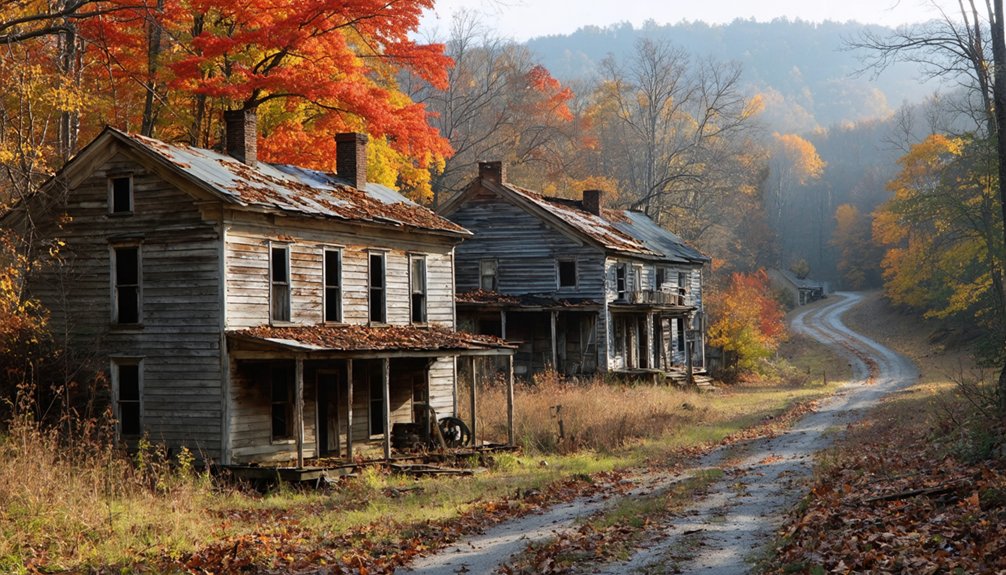
Route 7 Corridor: Farmstead Ruins and Shenandoah Valley Views
Stretching 390 miles from Alexandria to the Ohio River, Virginia’s Route 7 transforms from suburban sprawl into something far more haunting as it climbs toward the Blue Ridge Mountains.
Between Leesburg and Berryville, you’ll discover historic farmsteads gradually surrendering to vine and bramble, their stone foundations emerging through autumn’s copper carpet.
Park where old wagon roads intersect the highway, and short hikes reveal collapsed barns framed by blazing maples.
The corridor’s scenic valley overlooks provide dual rewards: panoramic views of the Shenandoah’s quilted landscape ablaze in October color, and glimpses of forgotten homesteads tucked into hollows below.
Early morning fog clings to these abandoned properties, creating ethereal tableaux where human ambition met mountain isolation.
You’re witnessing history reclaimed, one crimson leaf at a time.
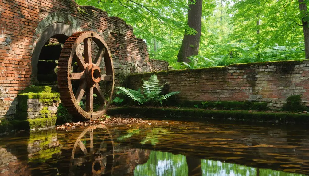
Floyd County: Highland Mining Towns Wrapped in Maple and Oak
- Hike Rocky Knob’s trails through forested mining remnants where autumn colors peak.
- Drive Gold Rush Road’s scenic backroads connecting abandoned copper and gold prospects.
- Tour thirteen water-powered mill sites marking Floyd’s faded industrial corridor.
- Visit Mabry Mill along Blue Ridge Parkway near preserved rural decay.
- Trace Trader’s Path routes where immigrant settlers preceded mining booms.
The county’s elevations transform these silent excavations into vibrant fall panoramas.
Coastal Virginia: Late-Season Foliage at Forgotten Settlements
While Virginia’s mountain ghost towns surrender their crimson leaves by mid-October, the coastal settlements cling to autumn’s palette well into November. You’ll find Wash Woods Ghost Town within False Cape State Park—accessible only by foot, bike, or boat—where cypress-built ruins from 1800s shipwreck survivors stand among maritime forest ablaze with late-season color.
Nearby in Mathews County, Old House Woods presents a haunting landscape where standing dead loblolly pines create skeletal silhouettes against transforming tidal marshes. These urban legends-steeped haunted locales reveal nature’s raw power: 150 square miles of Chesapeake Bay forest converted to marsh since the 1800s, their dying trees painting reddish-brown hues across expanding wetlands.
You’ll discover Revolutionary War ghost stories alongside cemetery headstones, where sea level rise crafts new wilderness from forgotten communities.
Frequently Asked Questions
What Permits or Permissions Are Required to Explore Virginia Ghost Towns?
You’ll need access permits for national parks like Great Falls, but most ghost towns don’t require special permissions. Always respect private property boundaries and stick to marked trails, letting you explore Virginia’s haunting ruins freely and responsibly.
Are Ghost Town Sites Safe for Children During Fall Foliage Visits?
Child safety requires vigilance amid autumn’s enchantment—uneven trails, hidden ruins, and leaf-slicked stones pose hazard considerations. You’ll navigate crumbling walls and rocky paths best with older kids, staying alert where history’s shadows meet nature’s breathtaking, unpredictable canvas.
What Photography Equipment Works Best for Capturing Ruins and Autumn Colors?
You’ll need a mirrorless camera with excellent autofocus, a versatile telephoto lens for isolating vibrant foliage against crumbling structures, and reliable camera stabilization like a lightweight tripod. Autumn lighting demands circular polarizers to eliminate glare and saturate those fiery colors.
Can Visitors Camp Overnight Near These Abandoned Settlement Locations?
You’ll find limited camping options near Virginia’s ghost towns. Most require checking camping regulations with county offices and securing local permits beforehand. Nearby state forests often offer primitive sites where you can sleep beneath star-filled skies surrounded by autumn’s crimson embrace.
Which Ghost Towns Have the Least Crowded Trails During Peak Foliage?
I don’t have data on trail crowding at Virginia’s ghost towns during peak foliage. However, you’ll find hidden history and excellent photography tips await at lesser-known sites like Matildaville, where freedom-seeking explorers discover autumn’s vibrant colors without typical tourist crowds.
References
- https://www.roadunraveled.com/blog/fall-foliage-virginia/
- https://www.virginia.org/blog/post/top-spots-colorful-foliage/
- https://vadogwood.com/2025/09/05/best-leaf-peeping-in-virginia-in-2025/
- https://krismariawanders.com/best-places-for-fall-colors-in-west-virginia-what-to-do-there/
- https://visitvirginia.guide/virginias-fall-foliage-the-ultimate-scenic-drive-guide/
- https://www.islands.com/2035167/matildaville-virginia-historic-abandoned-town-nestled-great-falls-national-park-hauntingly-beautiful/
- https://wvtourism.com/5-wv-ghost-towns/
- https://www.youtube.com/watch?v=Upekk1DDZeE
- https://northernvirginiamag.com/67-advantures-ghost-towns-of-virginia/
- https://pastlanetravels.com/matildaville-ruins/