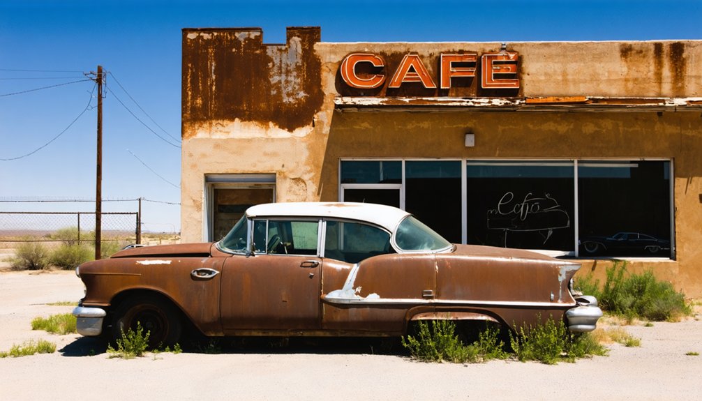
You’ll find Glenrio straddling the Texas-New Mexico border, where it emerged as a railroad town in 1901 before becoming a Route 66 icon. The town uniquely positioned its bars in New Mexico and gas stations in Texas due to state tax differences. Once bustling with roadside attractions and travelers, Glenrio’s fate changed dramatically when Interstate 40 bypassed it in 1973. Today, its abandoned Art Moderne buildings and empty streets tell a compelling story of America’s changing transportation landscape.
Key Takeaways
- Glenrio became a ghost town after Interstate 40 bypassed it in 1973, causing businesses to close and population to decline dramatically.
- Located on the Texas-New Mexico border, Glenrio was once a thriving Route 66 community with unique state-line business arrangements.
- The town retains 12 buildings and 4 structures on the National Register, showcasing early 1900s adobe and 1950s architecture.
- By the 1980s, Glenrio’s population dropped from several dozen to just two residents following the interstate bypass.
- The abandoned buildings and quiet streets serve as a time capsule of mid-century American road culture along Route 66.
The Birth of a Border Town
When the Rock Island Railroad established a siding in 1901, it planted the seeds for what would become Glenrio, a unique border town straddling Texas and New Mexico.
Originally named Rock Island, the settlement changed its name to Glenrio in 1908, combining Scottish “glen” and Spanish “rio” – though ironically, you’d find neither valley nor river nearby.
A town with a name blending two languages, promising valleys and rivers where none existed.
The early settlement grew alongside the Chicago, Rock Island and Gulf Railway’s expansion in 1905-1906. Ancient peoples had inhabited this area for millennia, as evidenced by Clovis-type tools discovered in the vicinity.
Adobe structures dotted the landscape as pioneers established essential services. By 1910, you’d have found the Kirk Patrick Hotel, grocery stores, a blacksmith, and even the Glen Rio Tribune newspaper serving the community. The town’s unique customs emerged as mail delivery required transport from the Texas depot to the New Mexico post office.
The town’s strategic location made it a crucial shipping point for local ranchers, who relied on the Texas-side depot to transport their wheat and cattle.
Life on the State Line
If you’d lived in Glenrio during its heyday, you’d have experienced a peculiar split in everyday services, where your mail arrived at the Texas depot but was distributed from the New Mexico post office.
You’d have found the town’s business geography shaped by state laws, with bars operating on the New Mexico side while gas stations clustered in Texas to take advantage of lower fuel taxes.
The federal government’s classification of Glenrio as a Texas town added another layer of complexity to life in this uniquely divided community, where residents regularly crossed state lines just to complete their daily routines. When Route 66 passed through town, it brought a welcome station near the state line and a surge of travelers who helped the local economy thrive. The town’s initial growth in 1905 came from small farmers who settled on 150-acre plots, establishing the agricultural foundation of the community.
Split State Services
Though Glenrio straddled the Texas-New Mexico border, the town’s split jurisdiction created a fascinating patchwork of services dictated by each state’s laws.
You’d find postal challenges as mail traveled from the Texas depot to the New Mexico post office, while service disparities shaped where businesses could operate. Different state regulations created a unique landscape where you couldn’t buy alcohol in Texas but could drink just steps away in New Mexico. The Texaco station built by Joe Brownlee became a bustling hub for travelers seeking lower-priced fuel. The town’s governance relied on informal citizen councils to handle local matters since there was no dedicated police force.
- Texas side dominated gas stations due to lower fuel taxes
- Mail service required manual transport across state lines daily
- New Mexico’s State Line Bar thrived while Texas stayed dry
- Railroad operations centered on Texas side until 1955 closure
- Post office remained in New Mexico despite federal recognition of Glenrio as primarily Texan
Quirky Border Economics
The state line running through Glenrio created a fascinating economic microcosm where businesses strategically positioned themselves to exploit each state’s regulations.
You’d find gas stations exclusively on the Texas side, where lower fuel taxes attracted both locals and travelers. Meanwhile, if you wanted a drink, you’d have to cross into New Mexico, as Texas’s dry county laws prevented alcohol sales.
This unique border trade created distinct commercial zones: Texas dominated the fuel business with Texaco and Mobil stations, while New Mexico cornered the market on bars and taverns, particularly the State Line Bar. The town’s strategic position along Route 66 connected travelers from Chicago to Santa Monica, making it a vital pit stop for weary motorists.
The town’s original identity as Rock Island in 1908 gave way to its more familiar name of Glenrio, reflecting its evolution from a railroad stop to a divided border community. These economic disparities shaped daily life until Interstate 40’s arrival in the 1970s, which diverted traffic and ultimately led to Glenrio’s decline, ending its remarkable split-state economy.
Unique Governance Challenges
Living astride the Texas-New Mexico border created unique governance challenges for Glenrio’s residents, who found themselves maneuvering through a complex web of dual jurisdictions and informal governance systems.
Without a formal municipal structure or local police force, you’d find a town that relied on grassroots decision-making and county law enforcement from both states. The development of Ozark Trail tourism in 1917 further complicated governance as the town struggled to manage increased traffic and visitors from both states. By the 1920s, the town had grown into a bustling stop with hotels, stores, and cafes that required careful coordination between both states.
- If you wanted a drink, you’d head to the New Mexico side due to Texas prohibition laws.
- You’d save money buying gas in Texas thanks to lower taxation rates.
- You’d deal with two different county sheriff’s offices for law enforcement.
- You’d attend community meetings instead of formal city council sessions.
- You’d navigate postal services that operated from both sides of the border.
The jurisdictional complexities affected every aspect of daily life, from where you’d shop to which laws you’d follow, creating a unique frontier existence that demanded adaptability from residents.
Glory Days Along Route 66
During Route 66‘s heyday, Glenrio transformed from a small railroad town into a bustling waypoint that captured the essence of America’s most famous highway.
You’d have found a vibrant community nostalgia here, with the Glenrio Tribune chronicling local life until 1934 and roadside attractions drawing travelers from Chicago to LA.
The Impact of Interstate 40
When Interstate 40 bypassed Glenrio in 1973, you’d have witnessed an immediate and dramatic shift in traffic flow as travelers abandoned the old Route 66 path through town.
You’d have seen local businesses, from motels to gas stations, quickly shut their doors as their customer base evaporated, with the Ehresman family relocating their operations before eventually closing altogether.
If you’d visited by 1985, you’d have found only two residents remaining in what had become a shell of its former self, marking the end of Glenrio’s vibrant community life.
Traffic Flow Shifts Drastically
As Interstate 40 bypassed Glenrio in 1973, the town’s bustling traffic patterns changed forever.
You’d no longer see the steady stream of travelers stopping at local businesses, as I-40’s design funneled traffic around the town completely. This new high-speed corridor transformed how people moved through the region, devastating the local economy that once thrived on Route 66’s slower-paced travel.
- Traffic shifted from stop-and-go local roads to continuous interstate flow
- Exit 0 became the only major access point for reaching Glenrio
- Large freight carriers replaced sightseeing travelers as primary traffic
- The bypass eliminated state line commerce that previously forced stops
- Local roads became eerily quiet, serving mostly resident vehicles
The interstate’s design, with limited access points and higher speeds, effectively isolated Glenrio from the vibrant cross-country traffic it once enjoyed.
Business Closures Follow Interstate
The completion of Interstate 40 in 1973 dealt a devastating blow to Glenrio’s business community, triggering a cascade of closures that would transform the once-thriving town into a ghost town.
You’d find the Phillips 66 station and Texas Longhorn Café among the first casualties as travel patterns shifted dramatically to the new highway.
Community Dreams Fade Away
Following Interstate 40’s completion in 1973, Glenrio’s tight-knit community watched their shared dreams dissolve into an uncertain future.
You’d find a town that once embodied economic resilience through Route 66 tourism now struggling to maintain its identity. The decline proved swift and merciless, transforming vibrant streets into silent reminders of community nostalgia.
- By the mid-1970s, local businesses shuttered their doors as highway traffic disappeared.
- Population dwindled from several dozen to just two residents by the 1980s.
- Motels, gas stations, and restaurants stood abandoned, their signs fading in the Texas sun.
- Historic buildings fell into disrepair despite national recognition in 2007.
Today, only one full-time resident remains to witness the town’s ghostly transformation.
Architectural Remnants and Cultural Heritage
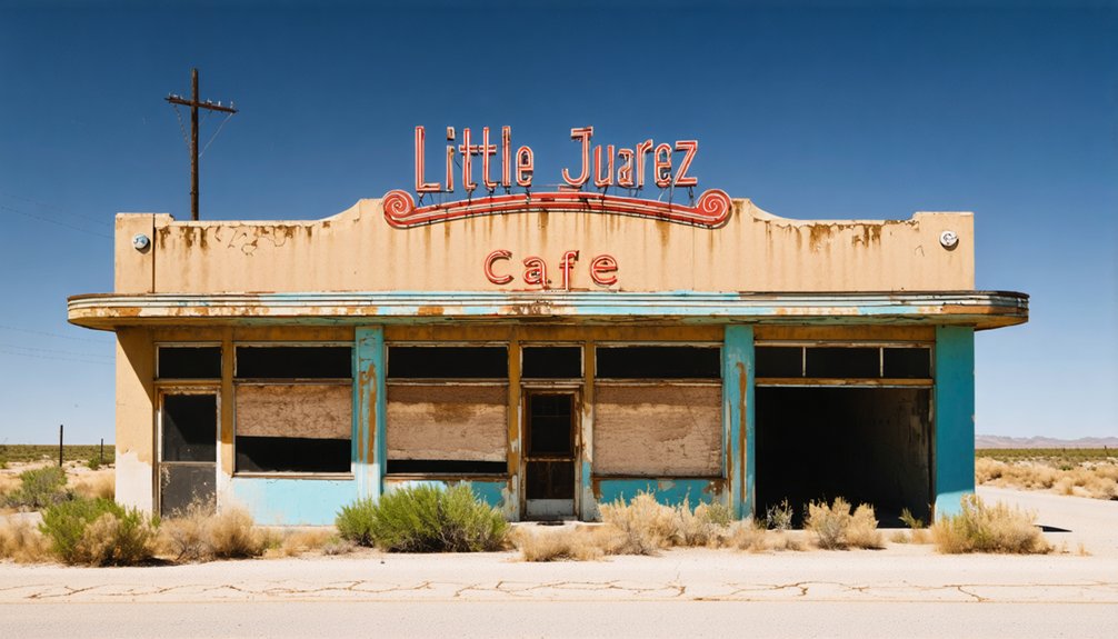
While Interstate 40 now bypasses this historic settlement, Glenrio’s architectural legacy spans 12 buildings and 4 structures that earned National Register Historic District status in 2005.
Despite modern highways rerouting traffic elsewhere, Glenrio’s sixteen historic structures stand as protected landmarks of America’s roadside heritage.
You’ll find a fascinating evolution from early 1900s adobe buildings to sleek 1950s Art Moderne designs, showcasing the town’s architectural preservation through different eras.
The cultural significance of Glenrio’s remnants tells a unique story of border life, where state laws shaped development patterns.
Texas-side gas stations and New Mexico-side bars reflect the intricate dance of commerce across state lines.
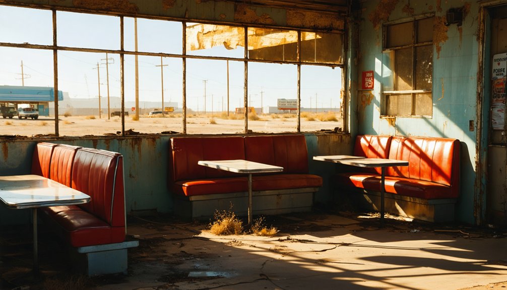
While most structures now stand abandoned, with only two buildings still occupied, they’re powerful reminders of mid-century American road culture.
The rusted neon signs, concrete foundations, and weathered walls serve as silent witnesses to Route 66’s golden age.
A Time Capsule of American Highway History
As Route 66 emerged from the dusty paths of the Ozark Trail in 1926, Glenrio stood at a pivotal crossroads of American transportation history.
You’ll find this ghost town’s story deeply woven into the fabric of highway nostalgia, from its railroad beginnings in 1907 to its heyday as a bustling Route 66 stop.
The town’s unique position on the Texas-New Mexico border created a fascinating mix of commerce, where you’d buy gas in Texas but drink in New Mexico.
- Experience the evolution from dirt roads to America’s first major highway system
- Discover how state borders shaped unique business practices
- See where travelers once lined up for fuel during Route 66’s golden age
- Witness the impact of Interstate 40’s bypass on small-town America
- Explore preserved structures that tell the story of mid-century highway culture
Frequently Asked Questions
Is It Legal to Explore and Photograph the Abandoned Buildings in Glenrio?
You’ll need explicit permission for legal exploration since most buildings are privately owned. While exterior photography from public roads is allowed, getting proper permissions guarantees you’re following regulations.
What Dangerous Wildlife or Hazards Should Visitors Watch Out For?
Watch for rattlesnakes in ruins and brush. You’ll need to guard against scorpion and insect bites, especially in abandoned buildings. Stay alert for coyotes at dusk and bring plenty of water.
Are There Any Guided Tours or Local Historians Available?
Like tumbleweeds drifting through time, you won’t find any official guided tour options or local historians here. You’ll need to explore independently or check nearby Route 66 museums for regional expertise.
Can Visitors Still Access the Original Route 66 Roadbed Through Glenrio?
You can drive the original Route 66 roadbed through Glenrio for a historic preservation road trip, but don’t go west of town – that section’s closed due to flood damage.
Do Any Descendants of Original Glenrio Residents Still Live Nearby?
Based on available records, you won’t find documented family connections to original settlers nearby today. Local heritage research shows most residents dispersed to larger towns after Interstate 40’s construction in 1975.
References
- https://www.legendsofamerica.com/tx-glenrio/
- https://www.youtube.com/watch?v=LiS5UTVrzlQ
- https://www.route66roadtrip.com/route-66-glenrio-texas.htm
- https://www.nps.gov/places/glenrio-historic-district.htm
- https://www.theroute-66.com/glenrio.html
- https://icatchshadows.com/a-visit-to-the-glenrio-ghost-town-on-old-route-66/
- https://www.islands.com/1912942/glenrio-new-mexico-abandoned-town-historic-snapshot-route-sixty-six/
- https://mix941kmxj.com/how-a-lone-car-and-a-ghost-town-make-a-beautiful-texas-love-story/
- https://www.atlasobscura.com/places/glenrio-ghost-town
- https://en.wikipedia.org/wiki/Glenrio


