You’ll find Massachusetts home to some of America’s most dramatic ghost towns, including four communities—Dana, Prescott, Enfield, and Greenwich—deliberately flooded in 1938-1939 to create Quabbin Reservoir, displacing over 2,500 residents and relocating 7,500 graves. Dogtown, abandoned by 1830, now features cellar holes and boulder inscriptions amid haunted wilderness. Long Point residents famously floated 30 houses across Cape Cod waters during their 1840s evacuation. The deadly Hoosac Tunnel, which claimed nearly 200 lives during its 1851-1875 construction, reportedly harbors headless apparitions and ghostly miners. Below, you’ll discover the complete histories behind these submerged and forsaken settlements.
Key Takeaways
- Dogtown, abandoned by 1830, features cellar holes and glacial boulders amid wilderness, with rumors of witchcraft and vagrant outcasts haunting its trails.
- Quabbin Reservoir submerged four towns in 1938-1939, leaving visible cellar holes and ruins that inspire ghostly legends and spectral sightings.
- Long Point residents floated 30 houses across Cape Cod waters in the 1840s before abandonment, leaving pilings and Civil War earthworks behind.
- Hoosac Tunnel’s 24-year construction killed approximately 136-195 workers, creating a tragically haunted legacy through Western Massachusetts mountains.
- Haywardville mill town within Middlesex Fells features preserved foundations and waterwheel bases along hiking paths, remnants of 19th-century industrial decline.
The Submerged Towns of Quabbin Reservoir
When the Massachusetts legislature passed the Swift River Act in 1927, it sealed the fate of four towns in the Swift River Valley. Enfield, Prescott, Greenwich, and Dana would vanish beneath water to supply Boston’s growing demands. These historical displacements began at midnight on April 28, 1938, when the towns were legally dissolved, forcing 2,500 residents from their homes.
By 1939, everything was gone. Workers demolished 14 mills, six churches, and 13 schools. They exhumed 7,600 bodies from cemeteries and reinterred them at Quabbin Memorial Park.
The valley became a moonscape—every building razed, every tree cut. Thousands of workers, nicknamed “woodpeckers,” earned just 62.5 cents per hour during the Depression-era construction. On the towns’ final night, residents gathered for a Farewell Ball on April 27, 1938, featuring a parade, community dancing, and “Auld Lang Syne.”
The reservoir engineering created a 39-square-mile water supply holding 412 billion gallons. When filling was completed in 1946, four communities lay forever submerged beneath Massachusetts’ largest reservoir.
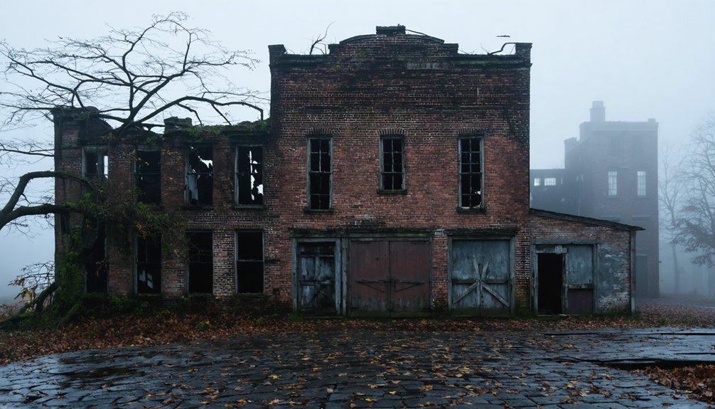
Dogtown: Essex County’s Abandoned Settlement
Unlike the deliberately drowned towns of Quabbin, Dogtown died from gradual economic strangulation. You’ll find this settlement began around 1641-1642 as Commons Settlement, thriving until 1750 with 75-80 prosperous homes.
Wars decimated the population—the Revolution and War of 1812 drove families toward better-defended coastal areas. Deforestation and new quarries emptied the hamlet by 1828.
The final resident, freed slave Cornelius Finson, left for Gloucester’s poorhouse in 1830. As wealthier families departed, the empty homes attracted outcasts and vagrants, with persistent rumors of witchcraft and offerings to the so-called “Queen of the Witches.”
Today you can explore numbered cellar holes and Roger Babson’s Depression-era inscribed boulders marking trails through the ruins. The landscape features Whales Jaw, the most famous glacial erratic in northern Dogtown, standing among numerous boulders shaped by glacial retreat. Hidden artifacts reveal indigenous history spanning 12,000 years, including PaleoIndian materials at Site 19-ES-64. Archaeological surveys from 1918-2019 document pre-Contact presence throughout this haunting wilderness.
Long Point’s Isolated Fishing Community
While Dogtown succumbed to gradual abandonment, Long Point experienced one of America’s most unusual town deaths—its residents simply floated their homes across the harbor.
Long Point’s residents executed an extraordinary exodus—floating entire houses across Cape Cod waters rather than surrendering them to abandonment.
You’ll find this remote Cape Cod settlement was established in 1818, thriving with 200 residents by the 1840s. The fishing village boasted six windmills, a general store, and facilities supporting maritime legends who harvested mackerel and bass from surrounding waters.
Economic pressures from larger commercial operations and devastating coastal storms forced families to act.
Beginning in the late 1850s, they transported approximately 30 structures across the water on casks—an engineering feat that saved their properties from becoming historical shipwrecks. Specialized deacons moved buildings including houses and even a schoolhouse across Provincetown Harbor on rafts.
By 1861, only two houses remained.
Today, Long Point Lighthouse stands sentinel over scattered pilings and Civil War earthworks, marking where an entire community once defied Cape Cod’s unforgiving coastline. A WWII cross memorial honors Charles Darby, adding another layer to this site’s rich military history.
Haywardville Mill Town Ruins
You’ll find Haywardville’s remnants hidden within the Middlesex Fells Reservation, where Nathaniel Hayward’s once-thriving rubber mill operation employed 38 workers before declining in the late 19th century.
The Commonwealth of Massachusetts acquired the abandoned site in 1894, transforming the deserted industrial hamlet into part of the public park system that became the Middlesex Fells Reservation.
Today, you can explore the mill town’s stone foundations and ruins along a 1.5-mile trail loop through the Spot Pond Archeological District in Stoneham’s Virginia Woods section. This tiny hamlet was once a significant hub powered by Spot Pond Brook, driving three centuries of water-powered mills that held local, regional, and national importance. The site includes 11 historic markers offering a self-guided tour through the area’s industrial past.
Mid-19th Century Industrial Decline
The rubber industry’s explosive growth in Haywardville couldn’t withstand the forces that would ultimately doom the settlement. By the mid-1800s, industrial decline accelerated as steam and electric power replaced water-dependent operations.
You’d find larger, more successful businesses overshadowing Haywardville’s mills, building modern factories elsewhere with steam engines that didn’t require brook locations.
The final blow came when neighboring communities—Medford, Malden, and Melrose—seized Haywardville’s water rights to Spot Pond Brook. Without adequate water flow, the four mills couldn’t power their wheels, gears, and manufacturing equipment.
The tiny brook simply couldn’t sustain industrial operations once municipalities diverted its flow. By 1894, you’d discover a mostly deserted village, its once-thriving rubber works and employee housing abandoned to the Massachusetts wilderness. The Commonwealth of Massachusetts purchased the site that same year, transforming the failed industrial landscape into parkland. All buildings were relocated to preserve the area, which now forms part of the Middlesex Fells Reservation.
Transformation Into Public Park
- Relocating all buildings to Ravine Terrace and Brook Street in Stoneham
- Clearing the site for complete park development
- Restoring lands to their pre-industrial character
- Preserving archaeological features like grist mill foundations and waterwheel bases
- Creating public recreational areas for hiking and exploration
- October 17, 1867: Thirteen miners died when a candle ignited naphtha fumes, causing the hoist building to collapse into the 1,028-foot shaft, trapping workers 538 feet below.
- 1865 Strike: Protesting workers burned buildings after fourteen men died in 1866 tunnel work.
- September 10, 1859: William Johnson, 29, was crushed by a falling arch.
- Nitroglycerin experiments: Early explosive testing added unprecedented dangers.
- Worker walkouts: Many believed the tunnel was cursed.
- Second-floor murder room serves as the most requested guest suite
- Original locks and doorways remain unchanged since 1892
- Fall River Historical Society displays crime scene photographs and the alleged murder weapon
- Three daily tours explore the unsolved case
- No hallways exist—you’ll pass through rooms as the family did
- Oliver Prescott, the surgeon who suppressed Shays’ Rebellion
- Colonel William Prescott, who led forces at Bunker Hill
- April 28, 1938: Official disincorporation alongside Dana, Enfield, and Greenwich.
- 2,500 combined residents faced displacement through reported bullying.
- Mid-August 1939: Flooding commenced, erasing established homes.
- 7,500 bodies relocated from town cemeteries.
- Ancient legends and spectral sightings now permeate Prescott Peninsula’s wildlife sanctuary.
- Crumbling foundations marking former mill operations
- Overgrown clearings where worker housing once stood
- Remnant extraction sites reverting to wilderness
- Deteriorating infrastructure invisible from modern roads
- Zero permanent residents inhabiting the forgotten site
- https://en.wikipedia.org/wiki/List_of_ghost_towns_in_Massachusetts
- https://985thesportshub.com/listicle/the-12-most-haunted-places-in-massachusetts/
- https://bostonghosts.com/a-terrifyingly-exciting-haunted-massachusetts-road-trip/
- https://www.youtube.com/watch?v=I8ERqDF8KxY
- https://www.timeout.com/boston/things-to-do/the-10-most-haunted-places-in-ma-that-you-can-visit
- https://historyofmassachusetts.org/ghost-towns-massachusetts/
- https://www.mahauntedhouses.com/real-haunts/
- https://www.tripadvisor.com/Attractions-g28942-Activities-c47-t14-Massachusetts.html
- https://vitabrevis.americanancestors.org/2019/09/lost-towns-of-the-quabbin
- https://www.harvardmagazine.com/2023/08/quabbin-reservoir-lost-towns-elena-palladino
You can now explore this hidden history where wilderness reclaimed what industry once dominated.
Exploring Middlesex Fells Ruins
Deep within the Middlesex Fells Reservation, stone foundations and crumbling mill structures mark where Haywardville once thrived as a bustling industrial center. You’ll discover remnants of four water-powered mills that operated along Spot Pond Brook for three centuries.
Industrial archaeology efforts, particularly the 2014 Industrial Eden project, uncovered archival photographs and documents that historians Ryan D. Hayward and Dee Morris used to reconstruct this forgotten community.
The ruins represent where Nathaniel Hayward and Charles Goodyear perfected vulcanization, birthing America’s rubber industry.
Historical preservation at the site reveals factory buildings, worker housing foundations, and waterworks that served 38 employees.
These scattered stones embody post-Revolution industrialization before late-19th-century conservation transformed the landscape, dispelling myths about this nationally significant manufacturing hub.
The Deadly History of Hoosac Tunnel
The Hoosac Tunnel, completed in 1875 after 24 years of construction through 4.75 miles of western Massachusetts mountain, earned its grim nickname “Bloody Pit” from the nearly 200 workers who died during its excavation.
You’ll find this engineering marvel’s history marked by catastrophic accidents, including the central shaft disaster of October 1867 that killed 13 men and the 1865 nitroglycerin explosion that claimed two experts.
Today, visitors report unexplained lights and mournful sounds within the tunnel, manifestations that workers first attributed to a curse over 150 years ago.
Construction Deaths and Tragedies
Between 1851 and 1875, workers boring through five miles of solid rock in western Massachusetts faced one of America’s deadliest construction projects. The Hoosac Tunnel’s construction claimed between 136 and 195 lives, making it a monument to industrial hazards that’d eventually contribute to the region’s urban decay.
The deadliest incidents included:
Paranormal Activity Reports Today
Since its completion in 1875, Hoosac Tunnel has accumulated over a century of documented paranormal reports that draw directly from its construction tragedies. You’ll find spectral sightings consistently documented, including headless apparitions glowing faint blue above the track bed and ghostly miners carrying picks and shovels on surrounding peaks.
Dr. Clifford Owens described one encounter as “profoundly chilling.” North Adams State College students captured muffled human voices on tape recordings in the central shaft during paranormal investigations.
Rail workers report bobbing lights from the eastern portal at night, moving like a lantern carried by invisible hands. Webster claimed disembodied voices ordered him into the tunnel before invisible hands attacked him with his own rifle, leaving documented injuries.
Professor Ali Allmaker reported sensing an unseen presence during his 1984 visit.
Lizzie Borden House and Its Dark Legacy

On August 4, 1892, a brutal double murder shattered the quiet respectability of 230 Second Street in Fall River, Massachusetts, when Andrew Borden and his wife Abby were killed in their own home.
Though Lizzie Borden was tried and acquitted, the historical crimes remain unsolved, cementing this location as one of America’s most infamous mysteries.
Despite courtroom vindication, the Borden murders endure as an American enigma, forever binding this address to unsolved brutality.
Today, you’ll find the preserved house operating as a bed and breakfast where haunted artifacts and original furnishings tell their silent story:
This snapshot of 1890s darkness draws freedom-seeking investigators worldwide.
Dana: A Worcester County Town Lost to Water
When Massachusetts needed to quench Boston’s growing thirst in the early 20th century, the town of Dana became a calculated sacrifice. Founded in 1801 and home to roughly 600-900 residents, this thriving manufacturing community vanished on April 28, 1938.
The Swift River Act of 1927 sealed Dana’s fate alongside three neighboring towns, displacing 2,500 people through eminent domain.
You’ll find Dana’s skeletal remains above the Quabbin Reservoir‘s waterline today. A four-mile trail leads you past cellar holes, crumbling foundations, and weathered stone walls. The Massachusetts Department of Conservation and Recreation maintains laminated signage marking where homes once stood.
Historical preservation efforts culminated in 2013 when Dana Common earned National Register status. Town memorabilia and photographs guide you through this government-mandated erasure of an American community.
Prescott’s Journey From Settlement to Reservoir

You’ll find Prescott’s story begins in 1822, when Hampshire County incorporated it from portions of Pelham and New Salem, naming the settlement after Revolutionary War Colonel William Prescott of Bunker Hill fame.
By the 1930s, this modest community of fewer than 300 residents faced an irreversible fate when Massachusetts authorities designated it for submersion beneath the Quabbin Reservoir.
The town’s disincorporation on April 28, 1938, followed by flooding in August 1939, transformed Prescott from a functioning settlement into one of Massachusetts’s most significant lost communities.
Early Incorporation in 1822
In 1822, Massachusetts legislators carved out the new town of Prescott from portions of Pelham and New Salem. They established a community along the ridge that separated the West and Middle branches of the Swift River. The incorporation process reflected historic governance practices of the era, creating another small farming settlement in the Commonwealth’s interior.
You’d find Prescott’s foundation built partly on Equivalent Lands—territory the Province of Massachusetts Bay had provided to Connecticut Colony settlers.
The town honored two Revolutionary War figures:
It also consisted of three modest villages: North Prescott, Atkinson Hollow, and Prescott Hill.
The economy centered on farming, dairying, and small-scale lumbering.
The population never exceeded 500 residents throughout its existence.
Submerged for Water Supply
Boston’s growing thirst for water sealed Prescott’s fate in 1927, when the Massachusetts State Legislature passed the Swift River Act to create the Quabbin Reservoir.
You’ll find that Prescott, alongside Dana, Enfield, and Greenwich, faced disincorporation on April 28, 1938. The least populated of these towns, Prescott harbored under 300 residents by 1900.
Between 1930 and 1939, crews constructed Winsor Dam and Goodnough Dike, methodically destroying all structures and vegetation.
Over 2,500 residents lost their homes, receiving roughly $108 per acre. Workers exhumed more than 7,500 bodies from valley cemeteries for relocation.
Rising waters submerged connecting roads by 1940, transforming Prescott Ridge into a peninsula.
Today’s reservoir archaeology reveals submerged relics below the waterline, while cellar holes mark what authority couldn’t erase—evidence of communities sacrificed for progress.
Lost Communities Beneath Waters
Prescott’s transformation from settlement to submerged landscape began in 1822, when Massachusetts incorporated the town from portions of Pelham and New Salem. Built on Equivalent Lands granted to Connecticut Colony settlers, this Swift River Valley community peaked at 300 residents in 1900 before becoming the region’s least populated town.
The disincorporation timeline reveals a community’s forced sacrifice:
Today, you’ll find the majority of Prescott remains above water, though inaccessible—its cellar holes and ruins standing as haunted testaments to governmental power over individual communities.
Greenwich and the Swift River Valley Sacrifice

When Massachusetts legislators decided Boston needed a massive new water supply in the early 20th century, they set their sights on the Swift River Valley and sealed the fate of four towns. Greenwich, incorporated in 1754, fell first—submerged in 1928 due to its lower elevation.
Dana, Enfield, and Prescott followed, officially disincorporated on April 28, 1938.
On April 27, Enfield residents held a farewell ball, dancing until midnight marked their town’s end.
Despite opposition reaching the Massachusetts Supreme Judicial Court, over 2,800 residents were forced out.
Authorities demolished buildings and exhumed 7,500 graves for reburial.
By 1946, the Quabbin Reservoir was complete, leaving only hilltop islands and Greenwich legends of what lies beneath.
Today, Reservoir mysteries persist where ruins and cellar holes mark communities sacrificed for Boston’s thirst.
Hillsboro: Franklin County’s Forgotten Ghost Town
While the Quabbin Reservoir towns met their end through government decree, Franklin County harbors a different kind of lost settlement—one that simply faded from memory. Hillsboro emerged mid-to-late 19th century as a mill or mining site, thriving briefly before industrial exhaustion claimed it.
You’ll find this ghost town listed among Franklin County’s abandoned settlements, though it avoided the reservoir’s fate.
Today’s industrial archaeology reveals Hillsboro’s environmental impact through scattered ruins:
Unlike government-mandated relocations, Hillsboro’s abandonment reflects pure economic decline. The settlement peaked during 19th-century operations, then vanished as resources depleted, leaving only fragments for researchers exploring New England’s voluntary ghost towns.
Frequently Asked Questions
Can You Legally Visit and Explore These Massachusetts Ghost Towns?
You can legally explore several sites where history whispers through abandoned ruins. Historical preservation efforts opened Catamount State Forest, Dogtown, and Questing Reservation to adventurers seeking local legends, though Dana remains submerged and some locations prohibit trespassing.
Are There Guided Tours Available for These Haunted Locations?
You won’t find dedicated paranormal tours at these sites. Instead, you’ll explore through self-guided trails at Dogtown and Catamount, seasonal ranger walks at Haywardville, or MDC boat tours covering Quabbin’s historical legends and local folklore independently.
What Is the Best Time of Year to Visit These Sites?
Visitor crowds drop 30-50% during September and November, making these ideal months. You’ll enjoy ideal seasonal weather with 45-60°F temperatures, peak October foliage, and fewer tourists at sites like Dogtown and Quabbin Reservoir.
Do You Need Special Permits to Access the Quabbin Reservoir Areas?
You’ll need permits based on your group size and activities. Groups under 25 don’t require permits for daytime private access, but larger gatherings, night fishing, boating, and vehicular entry have specific permit requirements through Quabbin Visitor Center.
Which Ghost Town Has the Most Documented Paranormal Activity?
You’ll find Gallows Hill/Proctor’s Ledge holds the most documented paranormal activity through historical society research, eyewitness diaries, and ongoing paranormal investigations. This ghost town history spans centuries, with verified execution records from 1692 linking directly to reported supernatural phenomena today.


