
You’ll find Rhode Island’s most haunted ghost town, Hanton City, hidden in Smithfield’s forests—a settlement founded around 1676-1677 that was abandoned by the 1850s, leaving only crumbling stone foundations and Native legends. Napatree Point‘s summer colony vanished entirely when the 1938 hurricane’s 125 mph winds killed fifteen residents and buried Fort Mansfield’s ruins beneath sand. The Ramtail Factory in Foster echoes with reports of Peleg Walker’s ghost, while forgotten cemeteries mark King Philip’s War casualties. The remnants tell stories that colonial records alone can’t capture.
Key Takeaways
- Hanton City in Smithfield, settled around 1676-1677 and abandoned by the 1850s, features stone foundations and lingering Native legends.
- Fort Mansfield at Napatree Point, built 1899-1901 and destroyed in 1938, has crumbling batteries and gun emplacements with graffiti-covered ruins.
- Ramtail Factory in Foster, established 1822 and burned 1873, is associated with ghost sightings including partner Peleg Walker’s specter.
- Nine Men’s Misery memorial marks a 1676 mass grave where nine captured militiamen were tortured to death during King Philip’s War.
- Foster’s Cemetery 26 and Cemetery 45 contain burials from King Philip’s War and hauntings by spirits like Aunt Lonnie Davis.
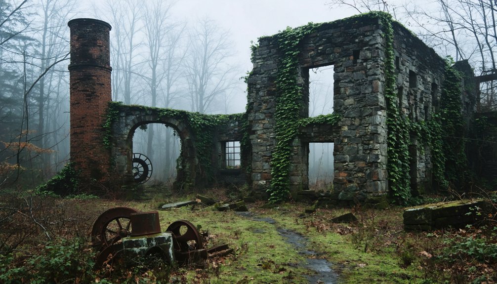
Hanton City: The Lost Community of Smithfield
Deep in Smithfield’s forests, where The Dow Chemical Company now owns the land, Hanton City’s stone foundations and crumbling walls lie hidden beneath decades of overgrowth. You’ll find this abandoned settlement near Hanton City Trail, accessible from 70 W. Reservoir Rd., though vegetation complicates your search.
Stone foundations and weathered walls mark Hanton City’s grave, swallowed by forest where industry once fled to factory floors.
Settled around 1676-1677 after King Philip’s War, the community peaked during Smithfield’s 1730s incorporation. Three English families—the Paines, Hantons, and Shippees—likely founded the settlement, possibly receiving land grants as payment for their military service. Residents farmed, quarried stone, and crafted boots for Providence markets, bartering meals and rum when cash ran scarce. The site contains numerous wells, including one approximately 20 feet deep, some nearly concealed within the constructed features.
The Industrial Revolution’s mechanized mills proved fatal—factory wages along the Blackstone River eclipsed handcraft profits. By the 1850s, you’d find only empty buildings on state maps.
Today, Native legends and folklore tales whisper through the Alfred Smith Cemetery‘s three remaining gravestones, marking this vanished community.
The Mysterious Origins and Theories of Hanton’s Settlers
You’ll find two competing explanations for Hanton City‘s founding, each rooted in Rhode Island’s turbulent 17th and 18th centuries. The first theory suggests three English families—the Paines, Hantons, and Shippees—received land grants around 1676-1677 as payment for service in King Philip’s War, establishing a yeoman farming settlement.
Alternatively, the community may have formed from Loyalist refugees, possibly exiled Tories from Newport who were banished to Smithfield and Glocester in 1776.
Though evidence remains unclear whether their isolation resulted from forced relocation or voluntary separation from Patriot-controlled areas.
The Harrington family is believed to be among the primary settlers, with their graves located in a local cemetery. However, these theories lack concrete evidence and remain unsubstantiated, contributing to the continued silence regarding the true origins of Hanton City.
Post-War Settlement Possibilities
According to local historian Jim Ignasher, the most credible theory places Hanton City’s origins in the immediate aftermath of King Philip’s War. You’ll find the settlement likely emerged around 1676-1677, when three English families—the Paines, Hantons, and Shippees—arrived in this remote territory.
The land may have been granted as compensation for military service during the brutal 1675-1676 conflict, a common practice that resolved both pre-war colonization debts and land grant disputes. This rocky, marshy terrain wasn’t prime real estate, which explains why it became available to lower-class veterans.
The area’s extreme isolation from main Smithfield made it ideal for families seeking autonomy from colonial authority. By the 1730s, when Smithfield officially incorporated, Hanton City had reached its peak population.
Refugees and Exiles Theory
Could Hanton City have sheltered those fleeing political persecution or colonial authority? Several theories suggest the settlement served as sanctuary for displaced populations.
Speculation persists that Loyalist exiles from Newport relocated to Smithfield in 1776, establishing an isolated community away from Patriot authorities. The remote location fueled theories of forced exile or voluntary seclusion among Crown sympathizers.
Another hypothesis proposes the site functioned as Native American refuge following King Philip’s War (1675-1676). Three English families—the Paines, Hantons, and Shippees—received land grants during this period, possibly displacing indigenous groups who sought refuge in surrounding wilderness.
Yet local historian Jim Ignasher dismisses these romantic narratives. Providence records confirm English settler origins, while Thomas Hanton’s 1889 account attributes abandonment to economic hardship rather than political persecution. These exile theories remain folklore without supporting evidence.
Napatree Point: Destroyed by the Hurricane of 1938
On September 21, 1938, the most destructive storm in New England history struck without warning, forever erasing a small summer colony from Rhode Island’s coastline.
Napatree Point, home to 39 summer cottages housing 42 people, vanished within minutes as 17-25 foot storm surges swept everything into Little Narragansett Bay. These abandoned structures now fuel urban legends across Watch Hill.
Key Details of the Devastation:
- Storm waves demolished the cement seawall and plowed over rooftops, killing 15 residents.
- The entire peninsula was severed from Sandy Point, migrating 1.5 miles north.
- Property losses reached $306 million ($4.7 billion today) across the region.
- Concrete staircases still emerge at low tide, marking where families once lived.
- Looting occurred during the floods as Providence’s downtown submerged under more than 13 feet of water.
The morning began deceptively calm, with residents enjoying warm and pleasant water during their swims, unaware of the catastrophe building offshore. Today, Napatree remains a wildlife refuge, undeveloped for eight decades, its ghostly remnants hidden beneath shifting sands.
Ramtail Factory: Where Ghosts Made the Census
Deep in Foster’s woodlands stands what remains of a woolen mill that earned the most unusual distinction in Rhode Island history: official recognition as haunted in the 1885 state census.
The Ramtail Factory’s tragic legacy began May 19, 1822, when partner Peleg Walker was discovered hanging from the shift-change bell rope at age 35. Whether murder or suicide following bitter disputes with the Potter family remains debated.
Workers fled immediately, spooked by supernatural sightings of machinery starting spontaneously. The mill limped along until 1850, then sat abandoned until suspected arsonists torched it in 1873, attempting to exorcise its spirits.
The factory drew its nickname from the wool clipping process that shaped its early operations. Local legends persist of Walker’s ghost patrolling the foundation ruins with his candle lantern, ringing the night watchman’s bell through Foster’s darkness. Over two decades of research by Tom D’Agostino and Arlene Nicholson have documented the site’s paranormal history through photographs and historical investigation.
Forgotten Cemeteries and Burial Grounds

Scattered throughout Rhode Island’s colonial ghost towns, forgotten burial grounds preserve the state’s earliest settlers in overgrown obscurity. You’ll find Hanton City’s lonely cemetery holding just two graves—Alice Herrndon and Daniel Brown—marking post-King Philip’s War casualties from 1676. Ancient gravestones stand sentinel in Foster’s Cemetery 26, where 175 burials include Civil War soldiers’ markers near a once-bustling town’s ruins. The oldest stone at this remote site dates from 1805, with burials continuing through 1937.
Notable forgotten memorials include:
- Cemetery 45 – Haunted by Aunt Lonnie Davis and Betsey Grayson’s specter on the nearby bridge
- Sherman Lot Cemetery – Overgrown colonial-era burial ground on Wakefield Road in Pascoag
- Alfred Smith Cemetery – Final resting place of Smithfield’s earliest settler families
- Oak Hill Cemetery – Industrial-era grounds with spectral activity among eroded markers
These sites vanished beneath vegetation, their stories preserved only through crumbling stone and local legend. Hanton City’s cemetery joins other foundations and walls as remnants of the settlement founded in the late 1700s, before the entire community was abandoned by the early 1900s.
Fort Mansfield and Military Remnants at Napatree Point
You’ll find Fort Mansfield’s ruins scattered across Napatree Point, where the 1938 hurricane destroyed what military obsolescence had already abandoned.
The coastal defense installation operated from 1901 to 1928, built to protect Long Island Sound’s eastern approaches before war games exposed fatal design flaws in 1907.
Today’s concrete foundations and earthworks mark where 228 soldiers once manned disappearing gun carriages that couldn’t defend against attacks from their own blind spots.
Hurricane Destruction of 1938
On September 21, 1938, a Category 3 hurricane slammed into Long Island before tearing through Rhode Island at a forward speed of 60-70 mph. The storm transformed Napatree Point from a populated barrier beach into a devastated ghost landscape.
The storm’s 12-15 foot surge completely eroded the barrier, exposing Fort Mansfield‘s crumbling foundations and creating the desolate conditions that fuel today’s haunted legends.
The Storm’s Catastrophic Impact:
- 50 deaths occurred in the Watch Hill area as the surge obliterated every structure along Dune Road.
- Hurricane-force winds reaching 125 mph stripped away protective dunes, leaving military remnants isolated and vulnerable.
- 20-foot storm tide reshaped the entire point within 1.5 hours, creating the eerie, abandoned atmosphere central to urban legends.
- Complete erosion transformed Fort Mansfield from forgotten military site into a spectral ruin haunting Rhode Island’s coastline.
Military History and Structures
Following the devastation of 1938, visitors encounter the skeletal remains of Fort Mansfield, a coastal artillery installation that the United States Army constructed between 1899 and 1901 on the 60 acres of Napatree Point it had purchased three years earlier. Named after Civil War General Joseph K. Mansfield, this military architecture housed three batteries equipped with 8-inch and 5-inch guns defending Long Island Sound.
The fort’s 27 structures accommodated 130 enlisted men, but 1907 war games exposed a fatal design flaw—a dead angle allowing enemy vessels to approach undetected. Attackers could bombard the installation using simple coal barges.
Maritime legends persist around these concrete ruins, remnants of an obsolete fortress decommissioned in 1909, stripped of its weapons by 1917, and sold to private interests in 1928.
Exploring the Fort Today
While the United States Army dismantled most of Fort Mansfield‘s 27 original structures following its 1909 decommissioning, three concrete batteries persist at Napatree Point’s windswept tip. Their graffiti-covered surfaces mark where 8-inch and 5-inch coastal artillery once guarded Long Island Sound.
You’ll reach these remnants by hiking the barrier beach from Watch Hill village, where erosion effects become starkly visible in crumbling foundations and exposed gun emplacements. Fort reconstruction never materialized after the 1931 foreclosure, leaving 60 acres open for public exploration.
What You’ll Discover:
- Battery Wooster’s distinctive 8-inch disappearing carriage positions
- Scattered concrete foundations across the windswept point
- Rapid fire gun emplacements on eroded balanced pillar mounts
- Storm-altered landscape where military precision met coastal forces
The site offers unrestricted access—no gates, no guides, just abandoned history dissolving into Rhode Island’s coastline.
Nine Men’s Misery and King Philip’s War Legacy
During the brutal spring of 1676, Captain Michael Pierce led 60 Plymouth Colony militia and 20 Wampanoag warriors in pursuit of Narragansett forces who’d burned Rhode Island settlements and attacked Plymouth Colony.
At a bend in the Blackstone River near present-day Central Falls, approximately 1,000 Narragansett warriors ambushed Pierce’s command, killing most of his 65 men. Ten colonists were captured; nine endured torture to death in a swampy rise.
You’ll find America’s oldest war monument marking their mass grave on Cumberland Monastery property. English colonists erected the stone cairn in 1676, protecting it from 1790’s attempted archeological excavation by medical students.
The 1928 reconstruction by Trappists cemented the stones for historical preservation, adding a Rhode Island Historical Society plaque. This sacred site represents King Philip’s War‘s devastating toll on colonial expansion.
Exploring the Ruins: What Remains Today
Rhode Island’s abandoned settlements leave tangible traces across the landscape, from forest foundations to coastal fortifications.
Stone walls, crumbling fortresses, and forgotten cellars mark where Rhode Island’s past communities once thrived before nature reclaimed them.
You’ll discover Hanton City’s stone walls and preserved wells hidden along Smithfield trails, where urban legends whisper through the trees.
At Napatree Point, Fort Mansfield’s ruins emerge from sand dunes that swallowed an entire community after 1938’s hurricane, inspiring folklore tales of the lost town beneath your feet.
Key Sites Worth Exploring:
- Fort Wetherill’s graffiti-covered concrete bunkers overlook water from Jamestown’s cliffs
- Rocky Point’s decayed amusement structures blend into Warwick’s coastal parkland
- Ramtail Factory’s deteriorated mill remnants mark Rhode Island’s faded industrial past
- Hanton City’s intact cellar steps and corn crib stones reveal 18th-century agricultural life
These accessible ruins let you walk freely through history without restrictions or guided tours.
Frequently Asked Questions
Are There Any Guided Tours Available for These Haunted Ghost Towns?
You won’t find organized guided tours for Rhode Island’s ghost towns. You’ll explore Hanton City, Napatree Point, and Ramtail Factory independently through self-guided hikes, discovering historical preservation sites and folklore legends on your own terms.
What Is the Best Time of Year to Visit These Sites?
Fall’s absolutely perfect for exploring these historical preservation sites—you’ll find comfortable 50-60°F temperatures, stunning foliage framing tourist attractions, and minimal crowds giving you complete freedom to investigate Fort Wetherill’s bunkers and Rocky Point’s atmospheric ruins independently.
Do I Need Special Permission to Explore These Abandoned Locations?
Yes, you’ll need landowner permission for most sites due to legal restrictions on private property. While preservation efforts protect historical significance, unauthorized exploration constitutes trespassing. Research ownership status and seek explicit consent before visiting abandoned locations.
Have Any Paranormal Investigations Been Conducted at These Sites?
Yes, investigation teams have explored these sites. Tom D’Agostino’s documented ghost tour at Hanton City used paranormal equipment in crumbling cellars. However, you’ll find most investigations remain informal—local enthusiasts rather than TV crews conducting formal probes at these forgotten settlements.
Are These Ghost Towns Safe to Visit Alone or at Night?
You’ll find these sites physically accessible, though safety precautions matter—bring lights, check local regulations, and inform someone of your plans. Night visits pose navigation risks in wooded areas, while coastal sites require tide awareness for your protection.
References
- https://www.youtube.com/watch?v=kpy7zlXYrAU
- https://newenglandwithlove.com/ghost-towns-in-rhode-island/
- https://www.youtube.com/watch?v=3bFcmv7IH40
- https://weird-island.simplecast.com/episodes/57-ghost-town-hanton-city-ky53imy0
- https://www.rimonthly.com/haunted-places-rhode-island/
- https://www.rhodeislandredfoodtours.com/2024/10/28/haunted-sites-of-rhode-island/
- https://en.wikipedia.org/wiki/List_of_ghost_towns_in_Rhode_Island
- https://en.wikipedia.org/wiki/Hanton_City
- https://smithapplebyhouse.org/arethereghosts/
- https://vitabrevis.americanancestors.org/2017/01/no-notorious-scandals