You’ll find 11 documented ghost towns in Massachusetts, ranking it 11th nationally for abandoned settlements. This count doesn’t include the four Quabbin Reservoir communities—Dana, Enfield, Greenwich, and Prescott—that were deliberately flooded in 1938 to create Boston’s water supply. Sources vary between 8 and 11 sites depending on classification criteria, with coastal settlements like Dogtown and forgotten mill villages scattered throughout the Commonwealth’s interior. The full story behind each community’s abandonment reveals distinct patterns of industrial decline, natural disasters, and infrastructure development.
Key Takeaways
- Massachusetts ranks 11th nationally with approximately 8 to 11 documented ghost towns, depending on abandonment criteria used by different sources.
- Four Quabbin Reservoir towns—Dana, Enfield, Greenwich, and Prescott—were flooded in 1938 after displacing 2,500 residents for water supply.
- Dogtown in Essex County, settled in 1693, declined after the Revolutionary War and features 12,000 years of archaeological history.
- Abandoned mill villages like Haywardville and Norton Furnace emerged from industrial decline, water rights disputes, and economic failures post-1870s.
- Ghost town counts vary because some sources exclude flooded Quabbin towns, while classification debates affect which sites qualify as abandoned.
The Total Count of Abandoned Settlements Across the Commonwealth
While national databases rank Massachusetts 11th among U.S. states with 11 documented ghost towns, the actual count fluctuates between 8 and 11 depending on how researchers define “abandoned.” These tallies systematically exclude the four Quabbin Reservoir towns—Enfield, Greenwich, Prescott, and Dana—which the state deliberately flooded in the 1930s to create Boston’s water supply.
You’ll find significant variation among sources. Loveexploring.com documents 11 sites, while Bostonuncovered.com highlights 8 haunting locations.
Wikipedia’s county-based inventory remains incomplete. This discrepancy stems from classification debates: some sites qualify as fully abandoned with vanished structures, others maintain sparse populations amid urban decay, while certain locations persist as historical relics with populations reduced to one-fifth their peak. Notable examples include Dogtown, a 3,000-acre rugged park with abandoned cellar holes located between Gloucester and Rockport on Cape Ann. By comparison, neighboring Rhode Island contains just 1 ghost town, making Massachusetts’s collection substantially more extensive than New England’s smallest state.
These categorizations directly impact your access to exploring these remnants of Massachusetts’s industrial and pioneer heritage.
The Quabbin Reservoir Project: Four Towns Lost Beneath the Waters
When the Massachusetts State Legislature voted in 1927 to condemn the Swift River Valley, they sealed the fate of four centuries-old communities—Dana, Enfield, Greenwich, and Prescott. These flooded settlements disappeared completely on April 28, 1938, when official disincorporation occurred at midnight.
Displacement stories reveal approximately 2,500 residents forced from ancestral lands, including descendants of Shays’s Rebellion farmers. You’ll find that 7,500 graves were exhumed and relocated, while sixty summer camps, fourteen mills, and entire railway systems disappeared.
Construction began in 1930, creating a 39-square-mile reservoir that took seven years to fill. Two massive earthen structures—Goodnough Dike and Winsor Dam—were built to contain the waters. Workers called “woodpeckers” earned 62.5 cents per hour, providing thousands of Depression-era jobs during the project. Today, only cellar holes and stone fenceposts mark Dana Common. The reservoir now provides 412 billion gallons to three million people—a stark trade between preservation of individual liberty and collective necessity.
Dogtown and Other Coastal Ghost Towns of Essex County
Beyond the flooded valleys of central Massachusetts, Essex County’s coastline harbors its own collection of abandoned settlements, none more enigmatic than Dogtown. You’ll find this 1693 settlement straddling Gloucester and Rockport, where pirate legends drove colonists inland to rocky highlands.
The community peaked at 80 families before Revolutionary War bombardments triggered its decline. By 1828, only widows and outcasts remained—women like Thomazine Younger, dubbed “Queen of the Witches.”
Recent archaeology confirms what officials long denied: Indigenous artifacts at Site 19-ES-64 prove 12,000 years of PaleoIndian presence.
Today, you’re free to explore protected trails threading through cellar holes and glacial erratics. Roger Babson’s boulder markers guide your journey through this contested landscape, where conservation efforts preserve both colonial and Indigenous heritage. The inspirational messages carved during the Great Depression include phrases like “Never try, never win” and “Keep out of debt.” The name “Dogtown” itself has become a place name requiring disambiguation, reflecting its cultural significance across multiple locations and contexts.
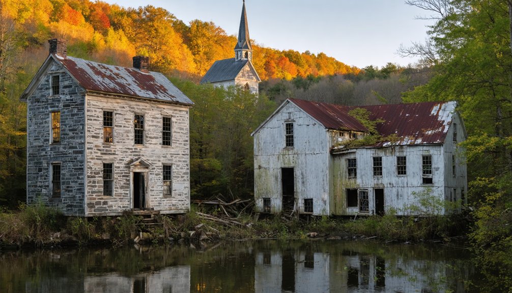
Forgotten Mill Villages and Rural Communities Throughout Massachusetts
Massachusetts’s industrial interior tells a different story of abandonment than its coastal settlements, with dozens of mill villages scattered across the Commonwealth’s rivers and streams facing systematic decline since the late 19th century.
You’ll find Haywardville’s foundations hidden in Middlesex Fells Reservation, where mills closed around 1870 after water rights disputes forced building relocations.
Norton Furnace, once producing 500 tons of iron annually, stands abandoned at what’s now Meadowbrook after 1890s operations ceased.
Industrial decline left Farnumsville, Fisherville, and Gilbertville struggling with identity preservation.
Historic preservation efforts confront massive challenges: Haverhill’s mill site requires nearly $10 million for dam removal, while Holyoke and Springfield face environmental cleanup costs that deter redevelopment.
Over hundred mills statewide have transformed into housing, yet many rural sites remain inaccessible ruins.
These settlements typically developed along rivers and falls where waterpower drove the textile machinery and manufacturing operations of the 19th century.
Catamount’s mountain farming community, first in Massachusetts to fly the US flag over a schoolhouse in 1812, exemplifies rural abandonment patterns that led to eventual state acquisition in 1967.
What Drove Entire Towns to Abandonment in the Bay State
While industrial decline gradually hollowed out Massachusetts’s mill villages, catastrophic forces drove entire towns to complete abandonment across the Commonwealth. You’ll find the most dramatic erasures in the Swift River Valley, where Dana, Enfield, Greenwich, and Prescott were systematically disincorporated between 1928-1938 for Quabbin Reservoir construction.
Nature wielded equal power—an 1860 hurricane obliterated Whitewash Village on Monomoy Island, forcing permanent evacuation as shifting sands prevented resettlement.
Geographic isolation doomed others: Dogtown’s inland families migrated coastward after 1812 when improved roads eliminated pirate threats, while Catamount’s treacherous terrain drove 20th-century residents away. At Cape Cod’s extremity, Long Point saw its population reduced dramatically to one fifth or less as ocean storms and freshwater scarcity made the narrow peninsula uninhabitable. Davis in Rowe thrived as a major iron pyrite mining village until a catastrophic cave-in in 1909 precipitated the mine’s closure three years later.
Today, historical preservation efforts transform these abandoned sites into tourism development opportunities, allowing you to explore Massachusetts’s vanished communities through protected trails and archaeological markers documenting their deliberate or natural demise.
Frequently Asked Questions
Can Visitors Legally Access and Explore Massachusetts Ghost Town Sites Today?
You’ll find legal access varies considerably—Dogtown offers maintained trails for urban exploration and photography opportunities, while Quabbin’s submerged towns remain off-limits. You should verify current ownership and regulations before visiting any site to make sure you’re exploring responsibly.
Are There Any Preservation Efforts to Protect Ghost Town Ruins and Artifacts?
You’ll find limited historical preservation efforts for Massachusetts ghost towns. Artifact conservation occurs mainly through National Register listings like Monomoy Point Light and state-managed sites such as Middlesex Fells Reservation, though systematic protection programs remain underdeveloped statewide.
Do Any Former Residents or Descendants Still Hold Claims to Submerged Properties?
No former residents or descendants hold property rights to submerged lands. Historical claims were settled through 1930s eminent domain proceedings, with the state providing compensation. You’ll find no active legal disputes over these reservoir properties today.
Which Massachusetts Ghost Town Is Considered the Most Haunted or Dangerous?
You’ll find Dogtown’s haunted legends most compelling—witches cursing travelers, paranormal forests, eternal hauntings. However, its dangerous ruins pose real threats: treacherous cellar holes, 3,000 acres of tangled wilderness, and isolated terrain where you’re truly free to get hopelessly lost.
Are There Guided Tours Available for Exploring Abandoned Settlements in Massachusetts?
You’ll find limited guided tours for Massachusetts’ abandoned settlements. Most sites like Dogtown require self-exploration, though Phantoms by Firelight at Old Sturbridge Village offers theatrical experiences combining historical architecture and local legends through documented interpretive programs.
References
- https://bostonuncovered.com/ghost-towns-massachusetts/
- https://www.loveexploring.com/gallerylist/188219/the-us-state-with-the-most-ghost-towns-revealed
- https://en.wikipedia.org/wiki/List_of_ghost_towns_in_Massachusetts
- https://www.youtube.com/watch?v=NVSMocyUa7E
- https://wokq.com/massachusettss-largest-lake-has-4-ghost-towns-underneath-it/
- https://historyofmassachusetts.org/ghost-towns-massachusetts/
- https://www.geotab.com/ghost-towns/
- https://live959.com/3-cities-potential-massachusetts-ghost-towns/
- https://senatorjocomerford.org/11-ghost-town-busters/
- https://www.youtube.com/watch?v=NnWdey6OaHM


