You’ll find between 21 and 32 officially recognized ghost towns across Missouri, though no authoritative registry exists to provide a definitive count. Wikipedia documents 32 locations while acknowledging the list’s incompleteness, and travel sources cite 21 comparable to other states. The actual number likely exceeds 100 when you include undocumented rural settlements and vanished communities along abandoned railroad corridors and mining districts. Differing classification criteria—from complete abandonment to severe population decline—create these numerical variations. The following sections reveal where these forgotten settlements cluster and what caused their demise.
Key Takeaways
- The number varies by source: LoveExploring reports 21, Wikipedia lists 32 recognized locations, and Geotab maps over 3,800 abandoned communities nationwide.
- No definitive registry exists; differing classification criteria lead to conflicting counts and interpretations of what constitutes a ghost town.
- Missouri ghost towns cluster along military, mining, and transportation corridors, particularly in St. Charles County, Phelps County, and the Ozarks.
- Notable abandoned towns include Arlington, Times Beach, Avilla, and Phenix, each offering distinct historical significance and visiting opportunities.
- Abandonment resulted from economic decline, resource depletion, environmental disasters like dioxin contamination, and infrastructure shifts affecting rural communities.
The Official Count: What Different Sources Report
The question of how many ghost towns exist in Missouri yields strikingly different answers depending on the source consulted. LoveExploring’s 2023 report documents 21 ghost towns, positioning Missouri alongside Hawaii and West Virginia.
LoveExploring’s 2023 report counts 21 Missouri ghost towns, placing the state alongside Hawaii and West Virginia in abandoned settlement frequency.
Wikipedia’s enumeration identifies 32 named locations, though explicitly acknowledging incompleteness.
Geotab’s national study maps over 3,800 abandoned communities nationwide, featuring Missouri examples like Phenix without providing state-specific totals.
Meanwhile, 24/7 Wall St. approaches the phenomenon through modern urban decay, identifying four ZIP codes with vacancy rates exceeding 16%.
This methodological divergence reflects fundamental disagreements about classification criteria—whether historical preservation efforts recognize nineteenth-century mining camps, absorbed townships like Hamburg and Howell, or contemporary abandonment zones.
You’ll find no authoritative registry exists, leaving researchers to navigate conflicting documentation independently.
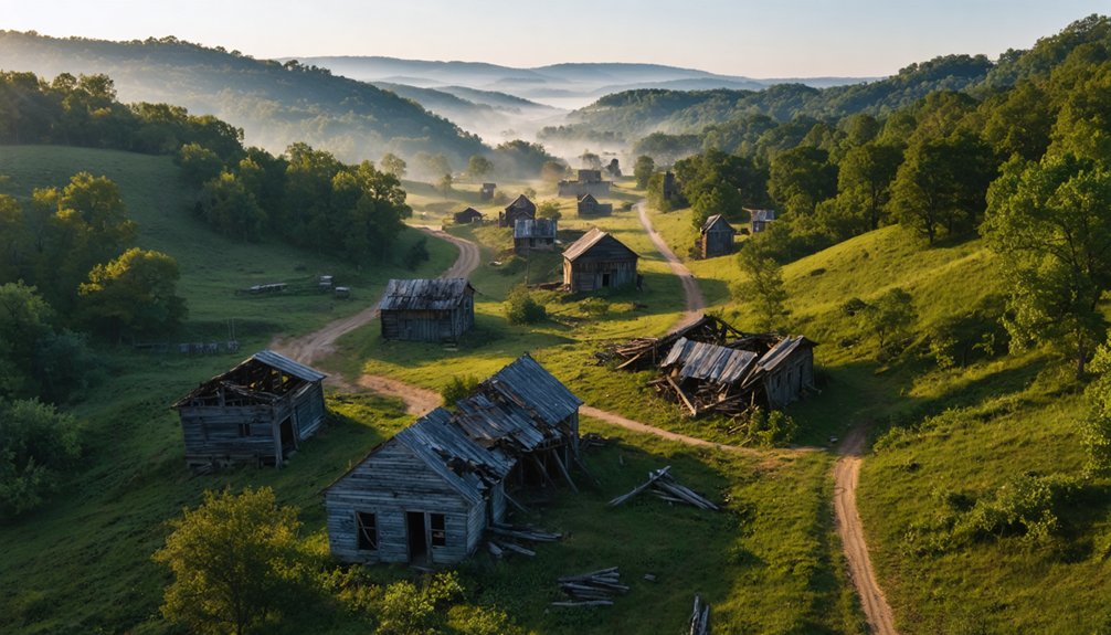
Where Missouri’s Ghost Towns Are Located
Missouri’s abandoned settlements cluster chiefly along strategic corridors that once sustained economic activity—military installations, mining operations, and transportation routes.
You’ll find St. Charles County’s Hamburg, Howell, and Toonerville absorbed into Weldon Spring Ordnance Works during WWII.
Phelps County’s Arlington sits along I-44, where remnant cabins offer tourism opportunities for road-trippers.
Pulaski County’s Bloodland disappeared when Fort Leonard Wood expanded in 1940, erasing a community of 100 residents.
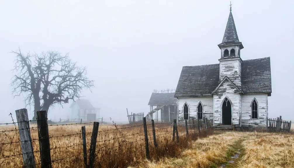
Stone County preserves Possum Trot‘s church ruins eight miles from Nixa, while Taney County harbors Melva and Rueter in the Ozarks.
Davies County’s Old Patensburg, founded in the mid-1800s and once thriving due to river and railroad access, was overwhelmed by the 1993 Midwest floods when residents chose relocation over rebuilding.
These sites represent significant historical preservation challenges, as documented settlements face perpetual decay.
Many of these locations are featured on Ghosttowns.com, serving as educational resources for virtual and physical exploration of Missouri’s abandoned communities.
Your exploration reveals how military needs, infrastructure development, and economic shifts systematically displaced entire communities throughout Missouri’s twentieth-century transformation.
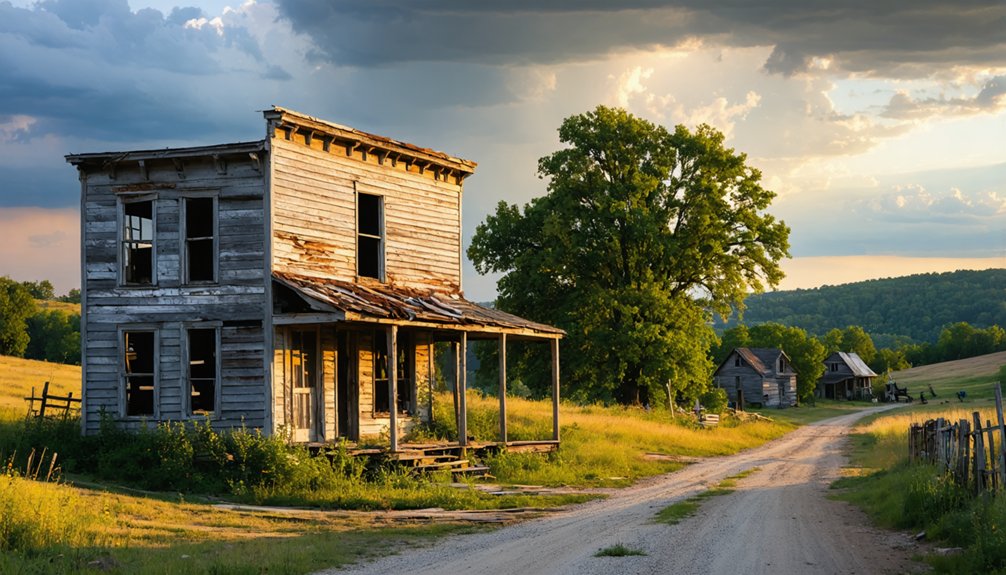
Most Notable Abandoned Towns Worth Visiting
Along Interstate 44’s corridor, Arlington stands as Phelps County’s premier ghost town destination, where collapsed bridges and weathered roadbeds provide tangible connections to Route 66‘s golden era.
You’ll discover authentic historic signage amid Gasconade River vistas, perfect for documenting urban decay through photography.
Times Beach presents Missouri’s most infamous abandonment story—dioxin contamination forced complete evacuation in the 1980s.
Now Route 66 State Park, interpretive displays reveal hidden histories of environmental catastrophe along the Meramec River.
Avilla preserves Capitol 66 Ghost Town‘s vintage motels and service stations in Jasper County, while Halltown’s antique shops blend commerce with abandonment.
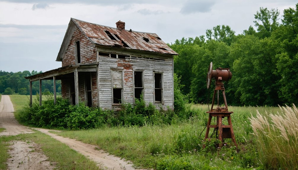
Phenix’s mining ruins showcase Greene County’s lead and zinc legacy through accessible foundations and remnants.
Phoenix, Missouri features the Phoenix Marble Company and a building marked “1922,” remnants of a company town that once housed approximately 500 residents around one of Missouri’s largest limestone quarries.
Burfordville’s Bollinger Mill & Covered Bridge represents one of Missouri’s best-preserved industrial sites, offering visitors a glimpse into 19th-century milling operations.
Each location offers documented evidence of Missouri’s industrial and transportation past, free for exploration.
Why These Towns Were Left Behind
Missouri’s ghost towns emerged from converging forces that systematically dismantled their viability as permanent settlements. Economic transformations—particularly railroad closures and bypassed routes—eliminated the commercial foundations that sustained communities like Meckings and Avilla throughout the mid-twentieth century.
Environmental catastrophes, especially the 1982 dioxin contamination of Times Beach and radioactive pollution in other settlements, compelled mass evacuations and permanent abandonment backed by federal intervention. Times Beach itself originated as a 1925 promotional scheme by the St. Louis Times, offering land parcels through newspaper subscriptions before economic depression transformed it from a summer resort into a working-class residential community.
Transportation infrastructure shifts proved equally devastating, as demonstrated when Spencer revived in 1926 due to Route 66 development only to be bypassed and abandoned again three decades later. Resource depletion and changing immigration patterns also contributed, with settlements like Karlin—established by Czech families from Bohemia—thriving for approximately fifty years before fading into history as economic opportunities shifted elsewhere.
Economic Shifts and Decline
When economic foundations crumbled beneath Missouri’s settlements, entire communities vanished with startling rapidity. You’ll find these abandoned sites resulted from systematic failures in single-resource economies. Mining operations exhausted ore deposits, compelling residents to seek opportunities elsewhere rather than remain in unproductive territories. Infrastructure bypasses severed economic lifelines when railroads and highways selected alternate routes, leaving once-thriving towns isolated from commerce.
The boom-bust cycles that created instant cities reversed just as quickly:
- Resource depletion forced mill and mine closures, triggering mass exodus
- Market shifts rendered natural resources obsolete through synthetic substitutes
- Transportation networks evolved, stranding communities dependent on obsolete routes
Historic preservation efforts now document these ghost towns’ community impact, revealing how catastrophic price collapses and industrial shutdowns transformed prosperous settlements into relics—testaments to economic volatility you’re free to explore. These sites maintain substantial remaining buildings that serve as visible evidence of their once-vibrant communities. Modern urban centers face similar challenges, as office vacancies and population loss create comparable downward spirals in once-prosperous districts.
Environmental Disasters and Contamination
Environmental catastrophes transformed thriving Missouri communities into uninhabitable wastelands through toxic contamination and repeated flooding. Times Beach exemplifies contamination’s devastating impact when Russell Bliss sprayed dioxin-laden waste oil on roads from 1972-1976. EPA tests revealed concentrations exceeding 100 parts per billion—300 times safe thresholds.
The 1982 Meramec River flood spread toxins throughout homes, prompting complete evacuation of 2,000 residents by 1985. Environmental cleanup required a specialized incinerator processing 265,354 tons of contaminated sites across Missouri, costing $200 million by 1997.
Similarly, Pinhook faced repeated inundation after the Army Corps constructed the Birds Point-New Madrid Floodway in 1932, sacrificing this community to protect Cairo. The 2011 flood delivered the final blow, creating another ghost town where federal disaster relief reached only nine individuals.
Counties With the Highest Concentration of Ghost Towns
You’ll find St. Charles County contains Missouri’s highest concentration of ghost towns, with four documented settlements abandoned primarily due to the 1941 Weldon Spring Ordnance Works project that displaced Hamburg, Howell, and Toonerville.
Phelps County follows with three sites—Arlington, Doolittle, and Yancy Mills—largely casualties of Route 66‘s shifting traffic patterns and rural economic decline.
Additional clusters emerge in Lawrence County and Taney County, each maintaining three and two ghost towns respectively, reflecting patterns of agricultural collapse and Ozarks isolation that depopulated communities throughout the twentieth century.
St. Charles County Leaders
St. Charles County demonstrates Missouri’s highest concentration of ghost towns, with four documented settlements lost to federal intervention. You’ll find Hamburg, Howell, Toonerville, and San Andres Del Misuri claimed by the 1941 Weldon Spring Ordnance Works project, which displaced entire farming communities for wartime military needs.
The shared fate of these towns reveals critical tensions between national security and local sovereignty:
- Government land acquisition forcibly relocated residents from established agricultural settlements
- Military expansion permanently erased community infrastructure and generational homesteads
- Environmental remediation through WSSRAP further prevented any community revitalization efforts
Today, you’ll traverse these former townsites along the Katy Trail, where vegetation conceals streets and foundations.
Historic preservation remains impossible—no substantial structures survive this federal transformation of private land into military-industrial complex, then recreational corridor.
Kansas City Regional Clusters
Ten documented ghost towns cluster within a 25-mile radius of Kansas City, creating Missouri’s most concentrated regional assemblage of abandoned settlements. You’ll find Jackson County contributing Pink Hill, Missouri Town, and Sugar Creek—remnants scattered across eastern zones where General Order Number 11 devastated pre-Civil War communities.
Clay County’s Harlem survived as a ferry port until the 1951 flood destroyed infrastructure, leaving only the fire-damaged Baptist Church as proof of a former prosperity.
Cass County’s Lone Tree and Lincoln County’s Cave extend this metropolitan periphery pattern.
Times Beach, though geographically distant in St. Louis County, shares thematic relevance through dioxin-forced evacuation.
Historical preservation efforts face challenges where industrialization and urban expansion erase physical evidence, complicating community revitalization initiatives.
This geographic concentration reflects Missouri’s volatile frontier legacy—where disaster, conflict, and economic transformation repeatedly unmade established settlements.
Taney and Phelps Counties
Taney County preserves Missouri’s densest concentration of documented ghost towns, with at least five abandoned settlements—Melva, Rueter, Possum Trot, Garber, and Gobbler’s Knob—scattered across its Ozark terrain.
Historical preservation efforts remain minimal, though sites like Garber’s ruins now occupy the Ruth & Paul Henning Conservation Park. You’ll find these locations through genealogical records and local legends that fuel Branson-area tourism.
Phelps County offers a stark contrast with only two confirmed ghost towns:
- Arlington: Abandoned mining settlement reflecting regional resource depletion
- Doolittle: Former railroad community documenting transportation-era decline
- Melva: Taney’s most tragic site, where tornado destruction killed eleven residents in 1920
Natural disasters, resource exhaustion, and railroad abandonment drove these communities into extinction.
Visible foundations at Melva and cemetery markers at Gobbler’s Knob provide tangible evidence of Missouri’s vanished settlements.
How to Find and Explore These Forgotten Places
While thorough ghost town inventories for Missouri remain incomplete across archival sources, researchers can systematically locate these abandoned settlements through multi-layered documentation methods. You’ll find Wikipedia’s partial lists, ghosttowns.com databases, and Legends of America’s Route 66 corridors provide initial coordinates.
Cross-reference these with county records identifying sites like Phenix’s mining structures or Hamburg’s Weldon Spring displacement. YouTube explorations reveal hidden locations that standard mapping services omit.
Before venturing, verify legal access—government remediation projects restrict former towns like Times Beach. Urban legends surrounding contaminated sites demand factual vetting through official documentation.
Prepare for off-road conditions: overgrown cemeteries, buried foundations along Katy Trail routes. Preservation efforts focus on structures like Burfordville’s Bollinger Mill, offering documented entry points.
Approach respectfully, documenting remnants while acknowledging these landscapes represent displaced communities seeking historical recognition.
Frequently Asked Questions
Are Missouri’s Ghost Towns Legally Accessible to the Public?
You’ll find Missouri’s ghost towns tantalizingly split: many sit on private land with strict trespassing concerns, while others welcome exploration through state parks and public roads. Always verify access rights beforehand—federal Superfund sites remain absolutely prohibited for your safety.
What’s the Difference Between a Ghost Town and an Abandoned Town?
Ghost towns differ from abandoned towns through their historical significance and sustained depopulation spanning decades. You’ll find ghost towns face greater preservation challenges due to prolonged structural deterioration, while abandoned towns retain more infrastructure and reversible economic potential.
Can You Buy Property in Missouri Ghost Towns?
You’ll find Missouri ghost towns offer limited real estate opportunities due to government ownership, environmental contamination, and historical preservation restrictions. Most sites lack delineated properties, though occasional private structures near Route 66 remnants might become available through standard channels.
Do Any Ghost Towns in Missouri Still Have Residents?
No, Missouri’s ghost towns don’t have residents—you won’t find any Zoom meetings in Times Beach. These abandoned settlements now serve as tourist attractions and historical preservation sites, offering you authentic glimpses into Missouri’s forgotten past through documented ruins.
What Should I Bring When Visiting Abandoned Missouri Towns?
You’ll need safety equipment, navigation tools, and documentation gear to explore historic architecture responsibly. Bring cameras, maps, protective clothing, and water. Research local legends through archival sources beforehand, ensuring you’re respecting private property and preserving these fragile sites.
References
- https://www.ghosttowns.com/states/mo/mo.html
- https://www.kcur.org/arts-life/2022-04-09/ghost-towns-are-all-around-kansas-city-if-you-know-where-to-look
- https://en.wikipedia.org/wiki/List_of_ghost_towns_in_Missouri
- https://blog.batchgeo.com/ghost-towns/
- https://www.youtube.com/watch?v=ERFnlJ5pjBg
- https://www.youtube.com/watch?v=eXBMX4O1-pQ
- https://www.geotab.com/ghost-towns/
- https://freepages.history.rootsweb.com/~gtusa/usa/mo.htm
- https://247wallst.com/special-report/2018/11/02/30-american-ghost-towns-3/
- https://www.loveexploring.com/gallerylist/188219/the-us-state-with-the-most-ghost-towns-revealed