You’ll find over 2,200 abandoned settlements across Iowa, shaped by railroad bypasses, coal industry collapse, and flood control projects. Notable sites include Buckhorn with its preserved creamery and church, Buxton—a once-thriving coal town of 10,000 residents—and communities like Coalport now submerged beneath Lake Red Rock since the 1960s dam construction. Economic shifts from the Great Depression through the 1980s farm crisis accelerated these abandonments. Organizations like Preservation Iowa now catalog endangered sites, while accessible ghost towns preserve Iowa’s frontier heritage through remaining structures and documented histories that reveal the complex forces behind each community’s disappearance.
Key Takeaways
- Iowa has over 2,205 abandoned places caused by flooding, economic collapse, railroad bypasses, and the Great Depression and farm crisis.
- Notable ghost towns include Buckhorn with its creamery and church, Elkport relocated after 2004 flooding, and coal town Buxton.
- Lake Red Rock submerged towns like Coalport, Cordova, and Percy after dam completion in 1969; remnants visible during low water.
- Railroad route changes determined town survival; bypassed towns like Carrollton declined while connected communities prospered until post-1983 closures.
- Historic structures include Villisca Axe Murder House, Edinburgh Manor, Squirrel Cage Jail, and Rockville’s 1845 grist mill ruins.
Why Towns Become Abandoned in Iowa
Understanding why Iowa’s towns fade into abandonment requires examining the convergence of natural disasters, transportation shifts, and economic collapse that reshaped the state’s landscape throughout the twentieth century.
You’ll find environmental hazards played an essential role—the 2004 Elkport flood submerged the town in over eight feet of water, while six communities were deliberately flooded in the 1960s to create Lake Red Rock.
Railroad abandonment accelerated urban decay after 1983, transforming the Wabash line into a nature trail.
Coal towns that peaked in the early 1900s never recovered from industry collapse, their populations stagnating for 120 years.
When you account for absorptions and name changes, 2,205 places actually disappeared, leaving behind controlled burns and decaying structures across Iowa’s rural landscape.
The strategic decision for flood control and development transformed Red Rock, Cordova, Dunreath, Rousseau, Fifefield, and Coalport into underwater ghost towns beneath Iowa’s largest lake.
Before the devastating flood, Elkport’s median household income of $24,375 reflected the economic challenges facing many small Iowa communities vulnerable to displacement.
Notable Ghost Towns Worth Visiting
You’ll find Iowa’s most accessible ghost towns scattered across the state’s rural counties, each preserving distinct evidence of 19th and early 20th-century settlement patterns.
Exploring these abandoned sites to explore in Iowa offers a unique glimpse into the history and culture of the region. Each location, from dilapidated storefronts to faded homes, tells a story of a bygone era. As you navigate the landscape, you’ll uncover the remnants of communities that once thrived amidst the rolling hills and vast fields.
Among these sites are ghost towns in National, Iowa, where the remnants of old businesses and homes stand as silent witnesses to the past. Visitors may stumble upon old rail lines that once connected these towns to bustling markets, now overgrown and barely visible. Each ghost town invites exploration, promising insights into the lives of those who once called this land home and the reasons for their departure.
These abandoned communities feature surviving structures ranging from Buckhorn’s operational-era creamery to Terra Haute’s deteriorating schoolhouse and general store.
When planning your visit, consider each site’s historical significance—whether it’s Carrollton’s former county seat status, Sunbury’s 1895 dance hall, or Elkport’s recent 2004 flood abandonment. Carrollton’s decline occurred after being bypassed by the Northwestern Railroad in 1867, leading to questions about the town’s future viability. Terra Haute’s overgrown remnants create a peaceful yet eerie setting that represents Iowa’s lost communities.
Historic Structures Still Standing
While many Iowa ghost towns have crumbled into prairie dust, a remarkable collection of historic structures still stands, offering visitors tangible connections to the state’s past.
The Villisca Axe Murder House, where eight people died in 1912, remains Iowa’s best-documented location for paranormal investigations.
Fort Dodge’s Vincent House, constructed in 1872, preserves the oldest building in town, where original owners James and Adeline Swain practiced spiritualism.
Chelsea’s Periwinkle Place Manor maintains its 1892 funeral home architecture as the Hrabak family’s legacy.
The Squirrel Cage Jail, built on a former church morgue, houses four documented deaths within its rotating cells.
Edinburgh Manor in Jones County, a former poor farm that operated from 1850 to 1910, witnessed over 150 deaths before becoming a home for the incurably insane until 2010.
Lake Red Rock, Iowa’s largest lake, submerged six towns including Percy, Swan, and Cordova when the dam was completed in 1965, with remnants occasionally visible during low water conditions.
These preserved sites attract those seeking haunted legends and authentic encounters with Iowa’s frontier history, standing as defiant monuments against time’s erosion.
Accessibility and Location Details
Since Iowa’s ghost towns scatter across diverse landscapes from Mississippi River bluffs to prairie valleys, planning your visit requires specific navigation details and accessibility information.
You’ll find Elkport (42.818°N, 91.015°W) along Highway 13 north of Guttenberg, where abandoned infrastructure dots the riverbank near campgrounds.
Littleport sits 10 miles northeast of Strawberry Point off County Road C9Y at 42.749°N, 91.368°W, with Turkey River remnants accessible for parking.
Donnan’s memorial sign marks its location five miles south of Wadena on Highway 150.
Mount Pisgah’s historic landmarks stand at 40.833°N, 94.400°W via County Road N54 south of Afton, offering trails through Mormon pioneer grounds.
Glendon welcomes you at 41.800°N, 94.400°W—take Redwood Road west from Menlo, then River Trail to the restored church.
Several ghost towns lie submerged by Lake Red Rock, including Conover, River Junction, and Marion, making them inaccessible except to divers with proper permits.
Many of these communities declined when railroad stations closed or moved, eliminating the transportation lifelines that sustained local commerce.
Unique Features and Attractions
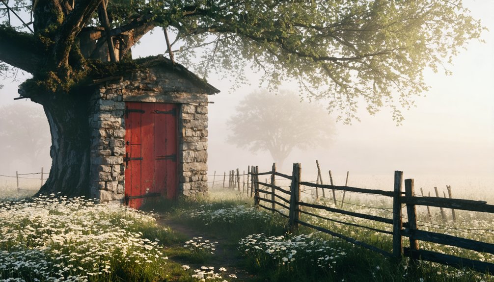
Each ghost town across Iowa tells its story through distinctive architectural remnants and historical landmarks that set it apart from typical abandoned settlements. You’ll discover Buckhorn’s crumbling creamery, once hosting 2,000 to 5,000 picnic attendees annually, alongside its whitewashed church and cemetery.
Elkport’s flood-ravaged remains from 2004 create haunting beauty at the river intersection.
Sunbury preserves its railroad heritage through an abandoned 1901 bank and legendary dance hall that operated until 1964.
Unlike secret mining operations or colonial settlements found elsewhere, Iowa’s ghost towns reflect agricultural and railroad economies.
exploring unique attractions in iowa can reveal the rich history and diverse heritage of the state. From picturesque small towns to stunning natural landscapes, visitors will find numerous hidden gems waiting to be discovered. Such experiences provide a unique perspective on Iowa’s cultural tapestry while honoring its past.
In addition to ghost towns, there are many historical sites in Iowa that showcase the state’s rich heritage. Visitors can explore restored farmsteads, iconic bridges, and indigenous landmarks that tell compelling stories of Iowa’s history. Each site not only highlights the past but also provides an opportunity to connect with the state’s agricultural roots and cultural evolution.
Monmouth’s Jackson County location offers early-stage abandonment, while Terra Haute’s overgrown schoolhouse and general store remnants in Decatur County provide peaceful exploration of Iowa’s vanished rural communities. The Buckhorn site earned recognition from Love Exploring as Iowa’s creepiest abandoned attraction, distinguished by its lack of interpretive plaques or historical markers. Several of these locations attract paranormal enthusiasts, with ghost hunters reporting orbs and strange noises at historic cemetery sites near abandoned settlements.
Buchanan County’s Lost Communities
Throughout Buchanan County’s settlement era, dozens of communities emerged across its townships, only to fade into obscurity as Iowa’s development patterns shifted.
You’ll find evidence of settlements like Atlanta in Newton Township, which operated a post office from 1859–1873, and Castvelille in Buffalo Township, serving residents until 1897. These communities reflected agricultural expansion and evolving transportation routes.
Archaeological excavations reveal little physical evidence of places like Cana in Cono Township or Pine in Liberty Township, where post offices briefly operated during the 1850s–1860s.
You’re confronting significant preservation challenges when researching these sites.
Williams’ History of Buchanan County and University of Iowa archives document specific operational dates, enabling you to trace each community’s trajectory from establishment through abandonment across the county’s townships.
Jackson and Clayton County Settlements
Iowa’s eastern border counties witnessed similar patterns of settlement and abandonment, though flooding and geographic challenges played more prominent roles in determining community survival.
You’ll find Rockville’s abandoned stone grist mill standing as the sole remnant of an 1845 settlement that thrived until railroads bypassed it in 1898.
Nearby Hurstville’s limestone kilns connect geologic and human history, while Cottonville operated its post office from 1851 to 1900 before fading away.
Elkport’s story differs dramatically—catastrophic 2004 flooding destroyed this Clayton County town, forcing residents to vote for complete relocation in 2006.
Today’s historic architecture tells these communities’ stories:
- Hurstville’s lime kilns preserve industrial heritage through interpretive centers
- Rockville’s mill ruins demonstrate water-powered manufacturing’s importance
- Local legends surrounding Elkport’s abandonment reflect nature’s ultimate authority
The Impact of Railroad Routes on Town Survival
You’ll find that railroad route decisions created winners and losers across Iowa’s landscape with brutal efficiency. When the Wabash Railroad bypassed Manti in favor of a route two miles north, it birthed Shenandoah while condemning the original settlement to obscurity.
Towns like Grant and Morton Mills experienced rapid booms upon rail arrival in the 1870s, only to fade within decades as shifting economic patterns and operational challenges made their railroad connections unprofitable.
Railroad Bypass Casualties
When railroads chose their routes across 19th-century Iowa, they wielded absolute power over which settlements would prosper and which would vanish.
Carrollton lost its county seat status in 1867 when Northwestern Railroad bypassed it, shifting political power to Carroll overnight.
Dalmanutha disappeared entirely after southern lines routed elsewhere post-1855, leaving only a cemetery as ghost town art.
Morrisburg’s hopes evaporated when rails favored competing stage lines, while Rockville’s 1898 post office closure marked its final shift from functioning community to mill ruins.
Railroad Bypass Casualties:
- Administrative death: County seat relocations followed rail decisions, stripping bypassed towns of governmental legitimacy
- Infrastructure obsolescence: Stage lines and existing railroad architecture became obsolete overnight
- Economic starvation: Freight and passenger connectivity determined survival in commerce-dependent settlements
Boom and Decline Cycles
Railroad construction crews swept across Iowa’s prairie like a temporary tide, leaving chaos and opportunity in equal measure. You’ll find their legacy in towns like Baxter, platted October 24, 1883, when tracks arrived.
Construction camps created instant economies—workers needed entertainment, supplies, and services. The Wabash Railroad’s 2,000-mile network sparked 1870s town births across the Midwest, while the Council Bluffs and St. Louis Railway construction generated similar boom towns.
But prosperity proved fleeting. Buxton exemplifies this cycle—swelling to 10,000 residents as coal demand fueled high wages, then vanishing when diesel replaced steam locomotives.
The industrial heritage you’ll discover in surviving railway architecture tells this story: stations built for bustling daily passenger service now stand empty, monuments to economic forces that giveth and taketh away.
Relocation’s Economic Consequences
As rail companies surveyed routes across Iowa’s landscape, they wielded absolute power over which settlements would thrive and which would wither. When railroad executives bypassed Manti, residents abandoned their town and relocated to Shenandoah, where tracks promised prosperity.
You’ll find industrial relics scattered across southern Iowa—evidence of communities that gambled everything on rail access and lost. Towns like Knowlton, Beaconsfield, and DeKalb became ghost settlements after the Humeston and Shenandoah line’s abandonment in 1983.
The town aesthetics you observe today—empty storefronts and crumbling foundations—tell stories of economic devastation.
Economic consequences of railroad relocation:
- Communities without rail service lost their economic anchors, forcing mass exodus to metropolitan areas
- Buxton’s 10,000 residents dispersed after coal demand plummeted post-WWI
- Six towns vanished beneath Lake Red Rock after floods eliminated remaining viability
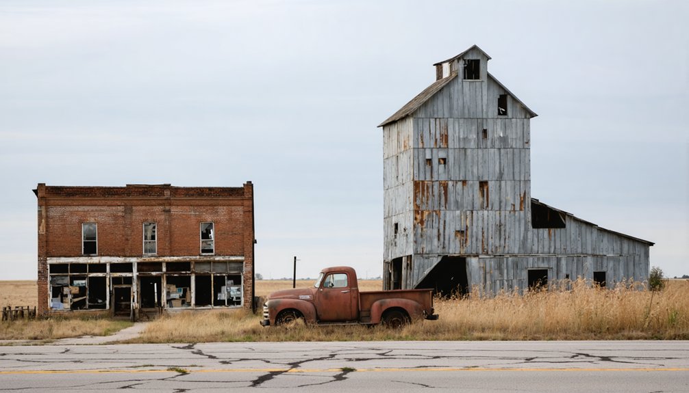
Structures and Landmarks That Remain Today
Throughout Iowa’s abandoned settlements, weathered structures stand as silent witnesses to communities that once thrived. You’ll find Buckhorn’s whitewashed church shuttered along Highway 64 in Jackson County, while its creamery crumbles nearby. Silent cemeteries like Burleson’s 1836 donation sit forgotten.
Rockville’s stone grist mill ruins cling to Maquoketa River banks—sole survivors after the 1898 railroad bypass erased sawmills, blacksmith shops, and hotels. Sunbury’s 1895 dance hall and 1901 bank building persist despite railroad decline.
Mount Etna offers a deteriorating church near Lake Acaria and dilapidated homes. Carrollton retains minimal landmarks after losing county seat status in 1867. Abandoned farms dot these landscapes.
Most properties remain private, though you can typically explore exteriors. No historical plaques commemorate these places—decay itself tells their stories.
Ghost Towns Submerged by Lake Red Rock

When the U.S. Army Corps of Engineers completed Red Rock Dam in 1969, you’ll find that six Marion County towns disappeared beneath Iowa’s largest lake. The dam, built after decades of devastating Des Moines River floods dating back to 1851, intentionally submerged Coalport, Cordova, Dunreath, Fifield, Red Rock, and Rousseau.
These communities—some dating to the 1840s—were systematically dismantled and flooded during the 1960s. This was done to create a flood control reservoir that now covers their former streets, businesses, and homes.
Red Rock Dam Construction
Federal authorization for Red Rock Dam came through the Flood Control Acts of 1938 and 1944, with the Senate Commerce Committee approving $15 million for the project in June 1944.
The U.S. Army Corps of Engineers broke ground on June 4, 1960, completing the massive rolled earth-fill structure by March 17, 1969.
You’ll find this engineering marvel stretches 5,200 feet long and rises 95 feet above the flood plain, controlling drainage from 12,320 square miles.
Key Construction Features:
- 14 hydraulic sluice gates and five massive tainter gates regulate water flow
- Passenger van-sized baffles in the stilling basin dissipate destructive energy
- Compacted cutoff trench extends to bedrock preventing dangerous underseepage
The $88 million project created Iowa’s largest lake, now central to ghost town tourism and urban legends about the submerged communities beneath.
Towns Lost to Flooding
Beneath Iowa’s largest lake lie six communities that once thrived along the Des Moines River in Marion County. Red Rock, Cordova, Dunreath, Rousseau, Fifield, and Coalport disappeared during the 1960s reservoir development.
You’ll find Red Rock was laid out by 1845, surviving multiple floods before finally succumbing to government planning.
Coalport prospered from its quarried red sandstone, while Rousseau bore Dr. James Rousseau’s name.
The Army Corps purchased structures in the flood plain, offering fair compensation to residents who couldn’t resist federal authority. Most buildings were demolished before water coverage.
Lost cemetery sites remain underwater except Red Rock’s, relocated above the waterline. During low water levels, you can spot submerged building foundations and roads leading nowhere—silent testimony to communities that once resisted the river’s power.
Southern Iowa’s Forgotten Towns
Southern Iowa’s rural landscape holds the scattered remains of dozens of communities that once thrived during the 19th and early 20th centuries. You’ll find Ringgold County’s abandoned infrastructure includes Blackmore Corner, which operated a post office from 1880-1895, and Athens Center, later renamed New Chicago.
In Appanoose County, Iconium still exists as an unincorporated settlement at Highway 142’s junction with 175.
Davis County’s Stiles once supported 100 residents in 1858 with three stores and a grist mill.
Hidden cemeteries and remnants mark these locations:
- Buckhorn in Jackson County preserves its cemetery, abandoned church, and historic creamery building
- Stanzel along Highway 92 maintains an active church among remaining houses
- Multiple coal mining camps operated throughout Marion County’s southeastern region
Economic Decline and Population Loss
The forces that transformed these southern Iowa settlements into ghost towns followed broader economic patterns that devastated rural communities across the state. Iowa’s agricultural crisis triggered massive population migration—the state lost half its family farms during the Great Depression, while the 1980s farm crisis destroyed 20,000 Quad Cities manufacturing jobs and left Waterloo with scores of abandoned homes.
You’ll find Bancroft lost 32.35 percent of its population between 1980 and 2010, marking Iowa’s steepest decline for communities over 1,000. Railroad abandonments accelerated this exodus, with Bancroft’s 1881 depot demolished in 1972.
Today’s challenges mirror historical patterns: younger residents departing, deteriorating infrastructure, and vanishing services. Without economic resilience, these towns can’t recover from systematic job losses and demographic collapse.
Preserving Iowa’s Ghost Town History
While economic forces continue erasing Iowa’s smallest communities, preservation efforts work to salvage what remains of the state’s ghost town heritage.
You’ll find organizations like Preservation Iowa documenting over 200 endangered sites across 69 counties since 1995, fighting urban decay through advocacy and technical assistance.
The State Historic Preservation Office coordinates restoration initiatives, while architectural salvage programs help small towns recycle materials from derelict buildings.
Crawford County’s Historical Preservation Commission maps “lost” settlements, preserving prairie heritage before it vanishes completely.
Key preservation approaches protecting Iowa’s abandoned communities:
- The Derelict Building Program assists towns under 5,000 residents with grants emphasizing material reuse and hazard elimination
- Historic cemeteries like Red Rock remain accessible despite reservoir flooding displacing entire settlements
- Trail conversion projects transform abandoned rail corridors into 63-mile recreational corridors linking restored downtowns
Frequently Asked Questions
Are Iowa Ghost Towns Safe to Explore and Visit?
You’ll find Iowa ghost towns generally safe but exercise caution around urban decay hazards like unstable structures. Respect historical preservation efforts and property rights. Remote locations mean you’re isolated, so prepare accordingly and always secure permission before exploring private sites.
Abandoned towns in Iowa often tell stories of past communities and economic shifts that shaped the region. As you wander through these remnants, take time to appreciate the architecture and artifacts left behind. Connecting with local historians can enrich your experience, offering insights into the lives of those who once called these places home.
In addition to exploring the rich history of these abandoned locations, consider attending annual festivals in ghost towns that celebrate their unique heritage. These events often feature local crafts, food, and music, creating a vibrant atmosphere that contrasts with the desolation of the surrounding buildings. Engaging with the community during these festivals provides a deeper understanding of the cultural significance of these places and the stories that continue to unfold.
Can You Legally Enter Abandoned Buildings in Iowa Ghost Towns?
No, you can’t legally enter abandoned buildings without owner consent. Iowa’s trespassing laws protect property rights even for deteriorated structures. You’ll face misdemeanor charges and fines up to $625, plus potential jail time if caught entering.
What’s the Best Time of Year to Visit Iowa Ghost Towns?
Fall paints Iowa’s ghost towns in photographer’s gold—crisp seasonal weather from mid-September through October delivers ideal lighting, fewer crowds for undisturbed exploration, and Halloween events that amplify your freedom to document abandoned structures with stunning photography opportunities.
Are There Guided Tours Available for Iowa’s Ghost Towns?
Iowa’s ghost towns lack organized guided tours, so you’ll explore independently. However, local legends survive through historical preservation efforts at sites like Buckhorn and Rockville, where archival documentation helps you uncover authentic stories without formal guides restricting your discovery.
How Many Total Ghost Towns Exist in Iowa Today?
Like scattered puzzle pieces across the prairie, you’ll find estimates ranging from 20 to 52 ghost towns. Historical preservation efforts and tourist attractions document over 30 named sites, though archival documentation suggests you’re free to discover even more forgotten places.
References
- https://kids.kiddle.co/List_of_ghost_towns_in_Iowa
- https://www.onlyinyourstate.com/experiences/iowa/ia-ghost-town
- https://freepages.history.rootsweb.com/~gtusa/usa/ia.htm
- http://www.iowapbs.org/article/8600/local-legends-around-iowas-haunted-locations
- https://pubs.lib.uiowa.edu/annals-of-iowa/article/13466/galley/121920/download/
- https://www.discoverguthriecounty.org/ghosttowns
- https://www.youtube.com/watch?v=L883pwCPOwE
- https://www.geotab.com/ghost-towns/
- https://kroc.com/ghost-town-what-happened-to-elkport-iowa/
- https://kxrb.com/this-iowa-ghost-town-is-completely-underwater/