You’ll find Iron Bridge, Texas (originally called Cotton Plant) along the Sabine River in Gregg County, where Stephen F. Austin established a settlement in 1827. The community thrived with steam gristmills, cotton production, and a crucial river crossing until the late 1800s. After its post office closed in 1891, Iron Bridge gradually declined despite its iconic Parker steel-truss bridge built in the 1920s. The ghost town‘s vanished structures and rich history offer fascinating glimpses into East Texas’s past.
Key Takeaways
- Iron Bridge was established in 1827 by Stephen F. Austin along the Camino Real de los Tejas as a thriving commercial center.
- The town’s economy centered around two steam gristmills and a shingle mill, with a post office established in 1876.
- Transportation infrastructure included the Parker steel-truss bridge built in the 1920s, spanning 1,285 feet across the river.
- The community declined after the Civil War due to changing trade patterns and railroad development, with the post office closing in 1891.
- The bridge’s indefinite closure in 2018 due to structural deterioration marked the final chapter in Iron Bridge’s ghost town status.
The Origins of Cotton Plant Settlement
While Spanish missions first introduced cotton cultivation to Texas in the early 18th century, it wasn’t until Anglo settlers arrived from Louisiana and Alabama in the early 1800s that cotton farming took root as a dominant agricultural force.
You’ll find that Stephen F. Austin’s colony, established in 1821, became the epicenter of cotton production, particularly in the fertile lands between the Brazos and Colorado Rivers.
Though many settlers officially declared themselves as stock-growers to obtain land grants, they primarily focused on cotton cultivation using slave labor.
Land grant settlers often misrepresented their farming intentions, masking their true focus on slave-driven cotton production.
These early farmers brought their agricultural techniques from the Deep South, adapting them to Texas’s unique environment. Similar to how John Neely Bryan would later establish key trade routes in Dallas, these cotton farmers developed vital transportation networks for their crops. The establishment of Greenhill Road before 1845 provided essential access for transporting agricultural goods.
Their cotton crops initially moved southward into Mexican markets, establishing crucial trade routes that would shape the region’s economic future.
Life Along the Sabine River
Beyond the cotton fields of Austin’s colony, the Sabine River carved a distinct cultural and ecological landscape along Texas’s eastern border. The river’s rich cultural heritage stems from Caddo Indian settlements that thrived here for over 500 years, later becoming a symbolic divide between the Old South and New Southwest. Early transportation relied heavily on river ferry services to move settlers and goods across the waterway. The waterway’s historical significance was cemented when it became the official boundary in 1819 between the United States and Spanish territory.
You’ll find a land shaped by seasonal rhythms, where environmental impact varies with annual rainfall averaging 52 inches and dramatic flow rates reaching 200,000 cubic feet per second.
- Ancient bald cypress trees and pine forests dominate the valley’s diverse ecosystem.
- Toledo Bend Reservoir, the South’s largest at 185,000 acres, controls water flow and generates power.
- Natural resources like clay, sand, and petroleum support local economies while shaping the region’s development.
The river’s meandering path continues to influence life here, supporting everything from timber harvesting to modern hydroelectric operations.
From Cotton Plant to Iron Bridge
As 19th-century settlers from Louisiana and Alabama pushed westward into Texas, they established a thriving community called Cotton Plant along the fertile banks of the Sabine River in Gregg County.
You’ll find that cotton cultivation quickly became the economic backbone of this settlement, with farmers implementing familiar agricultural practices from their Deep South origins. Following common practices of the era, many residents worked as tenant farmers, receiving two-thirds of their cotton’s value while working land owned by others.
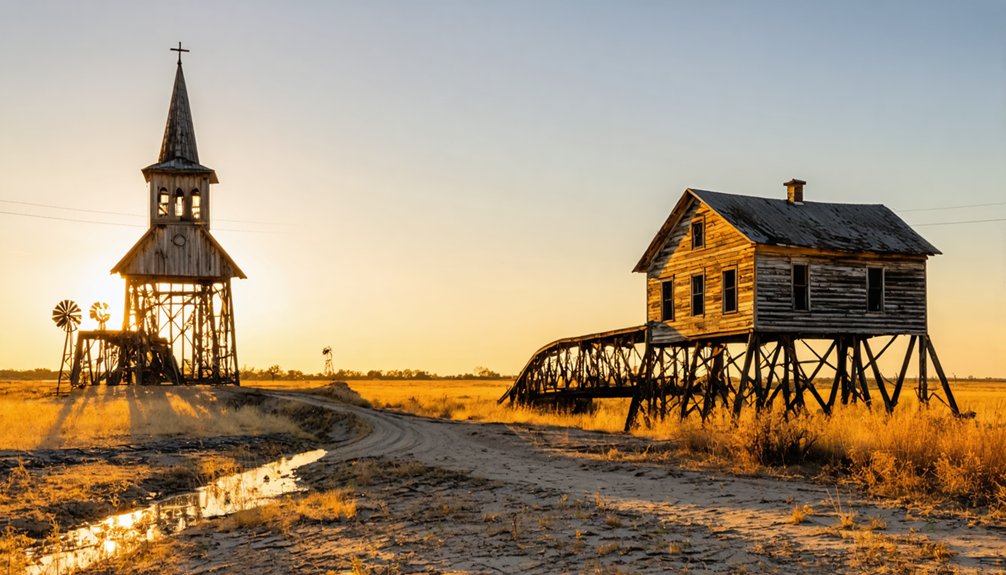
The community’s identity shifted as transportation needs evolved. When wooden bridges could no longer meet the demands of growing commerce, iron structures became essential for crossing the Sabine River.
This infrastructural advancement was so significant that Cotton Plant adopted the name Iron Bridge, reflecting the era’s progress.
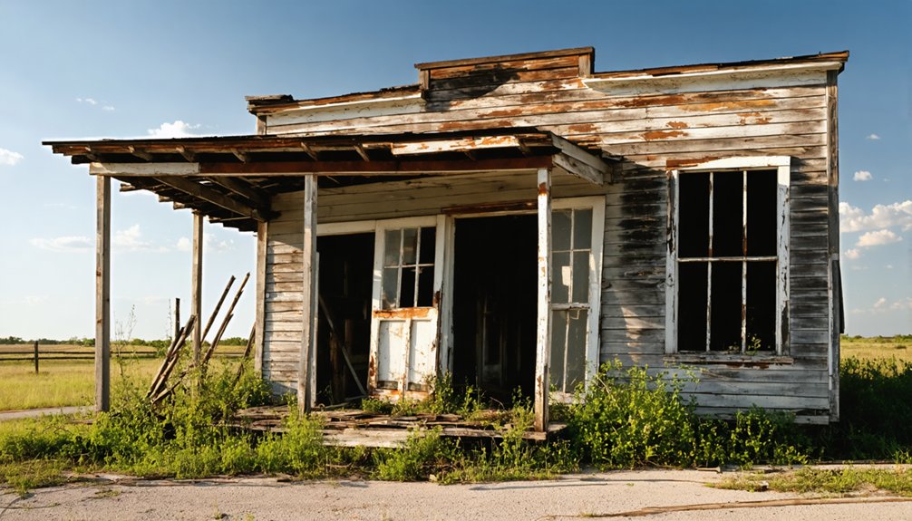
Today, you can explore what remains of this ghost town, where remnants of both its agricultural and industrial heritage still echo its transformation from a cotton-farming settlement to a bridge-centered community.
The Iconic River Crossing
Since regional commerce demanded reliable river crossings in the early 1920s, the Parker steel-truss bridge emerged as a landmark achievement spanning 1,285 feet across the Colorado River in Bastrop, Texas. The historic structure connecting Dallas to Irving provided a vital transportation route across the West Fork of the Trinity River near Eagle Ford.
You’ll discover this engineering marvel served as an essential link on the historic Old San Antonio Road, transforming dangerous ferry crossings into safe passage. Adding to automobiles’ increasing traffic after World War I necessitated this new bridge’s construction in 1923.
The bridge’s historical significance is evident in three key features:
- Three steel through-truss spans, each extending 192 feet
- Innovative combination of steel and concrete construction methods
- Status as one of Texas’s earliest surviving Parker steel-truss designs
Commerce and Daily Life
As you explore Iron Bridge’s economic history, you’ll find a bustling commercial center anchored by two steam gristmills and a shingle mill operating by 1884.
River transport along the Sabine played an essential role in the town’s commerce, enabling local merchants to ship cotton, lumber, and milled goods downstream to larger markets. Similar to San Antonio’s cast iron bridges, transportation infrastructure was crucial for moving heavy materials and goods during this period. Like the nearby settlement of Camden, Iron Bridge relied heavily on steamboat traffic for trade and economic growth.
The town’s marketplace featured three merchants, multiple craftsmen including blacksmiths and a wagon maker, and a saddler, serving both local residents and travelers crossing the river.
Mill Operations and Trade
While Iron Bridge’s industrial core revolved around its mills, the town’s commercial vibrancy peaked in the 1880s with two steam-powered gristmills and a shingle mill serving the community’s 150 residents.
The adoption of steam mill technology demonstrated the town’s commitment to industrial progress, breaking free from traditional water-powered operations. Similar to how every dollar donated helps preserve Texas history today, the town’s economic success relied on community support and participation.
You’ll find the town’s trade networks were supported by:
- A post office established in 1876, connecting Iron Bridge to broader commercial opportunities
- Bridge tolls ranging from 5 cents to $1.50, regulating the flow of goods and livestock
- Community-maintained roads essential for transporting milled products
Local farmers brought their grain to the steam-powered mills, where it was processed into marketable flour.
The shingle mill diversified the town’s production capabilities, adding wood products to Iron Bridge’s commercial offerings until the post office’s closure in 1891 signaled declining activity.
River Transport Economy
Before the construction of the Old Iron Bridge in 1890, the Colorado River served as both a lifeline and barrier for Iron Bridge’s economic development. You’d find local merchants and farmers relying on ferries to transport their cotton, wheat, and timber across the water, while river trade moved bulk goods downstream to distant markets.
The arrival of the iron bridge transformed the area’s transportation evolution, connecting previously isolated communities to essential rail networks and expanded trade routes.
You could now cross the river year-round, regardless of flooding, to reach schools, churches, and healthcare facilities. The bridge created a thriving multimodal transport hub, where river commerce merged with land-based trade.
Local businesses flourished near the crossing point, serving both river crews and land travelers, establishing Iron Bridge as a key commercial center.
Local Market Activities
The bustling commercial heart of Iron Bridge took shape around its crucial processing facilities, anchored by two steam-powered gristmills and a shingle mill by 1884.
You’d find local trade flourishing around these mills, where farmers brought their grain and timber for processing. The post office, established in 1876, became a crucial hub for market dynamics and communication.
Key features of Iron Bridge’s market activities included:
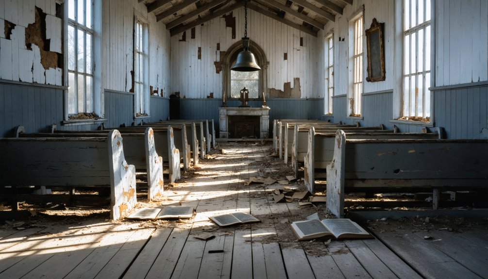
- Daily commerce centered around two churches that doubled as community gathering spots
- Farmers’ shift from subsistence crops to commercial cotton and wheat production
- Regular market days where locals exchanged goods, supplies, and information
Local stores and mills formed the backbone of Iron Bridge’s economy, while improved roads and bridges connected you to larger county markets for selling surplus crops and purchasing supplies.
Educational and Religious Foundations
Since its founding as a key settlement by Stephen F. Austin in 1827, Iron Bridge‘s location along the historic Camino Real de los Tejas created crucial community connections for both education and religious pursuits.
You’ll find historical significance in how the bridge’s construction improved access to rural schools and churches, while following the same route Spanish missionaries used in the 1600s to establish religious centers.
The bridge’s development drew funding from public school resources, highlighting the intertwined nature of transportation and education in early Texas.
This infrastructure proved indispensable for students and teachers traveling to distant schools, while simultaneously supporting religious gatherings and mission access.
The route’s preservation as part of the National Historic Trail system continues to remind you of the area’s rich educational and spiritual heritage.
Post-Civil War Transformation
Following the Civil War, you’ll find that Iron Bridge struggled to regain its economic footing as cotton trade patterns shifted and many residents relocated to areas with better commercial prospects.
The town’s population continued to dwindle through the 1870s and 1880s, despite efforts to maintain postal services and agricultural operations.
Economic Recovery Challenges
During post-Civil War reconstruction, Iron Bridge faced severe economic disruptions that reshaped its future as a rural Texas community.
The town’s economic resilience was tested as it struggled with damaged infrastructure, limited transportation routes, and disrupted cotton markets. Labor reorganization became necessary as the shift from plantation-style farming to smaller operations changed the region’s agricultural dynamics.
- You’d have witnessed the decline of river commerce as railroads diverted trade away from Iron Bridge’s traditional water routes.
- You’d have seen local farmers grappling with cotton market instability and reduced access to capital investment.
- You’d have noticed the community’s attempts to adapt through initiatives like the Old Iron Bridge Festival, though population shifts and labor shortages continued to challenge recovery efforts.
War-Era Population Shifts
The dramatic population shifts in Iron Bridge mirrored broader demographic changes across post-Civil War Texas, as the state’s population surged by 35.5% between 1860 and 1870.
You’d have witnessed significant war era migrations as former slaves either relocated or stayed to work as sharecroppers and tenant farmers.
The community, previously known as Cotton Plant, experienced a transformation as new settlers arrived, drawn by agricultural opportunities in cotton and sugarcane cultivation.
The emerging cattle industry attracted skilled drovers and cowhands, while seasonal labor patterns developed around farming cycles.
Infrastructure improvements, including new iron bridges and connections to major rail lines like Missouri-Kansas-Texas and Santa Fe, facilitated these demographic changes by making the area more accessible for trade and settlement.
Cotton Trade Evolution
While Iron Bridge’s pre-war cotton trade relied heavily on wagon transport to distant river ports, dramatic technological innovations transformed local agriculture after 1865.
The arrival of railroads near Iron Bridge revolutionized cotton shipping, allowing farmers to bypass traditional river routes and access broader markets.
You’ll find that cotton innovations dramatically changed the agricultural landscape:
- New steel plows broke through the tough Texas soil, while barbed wire enabled better field management.
- Improved cotton gins and compress facilities near rail lines boosted processing efficiency.
- Labor shifts from slavery to sharecropping brought waves of European immigrants and Mexican workers.
These changes helped Iron Bridge’s cotton production surge, though the community’s prosperity remained tied to volatile market forces and the challenging shift from slave labor to new workforce dynamics.
Economic Rise and Decline
Originally known as Cotton Plant, Iron Bridge’s economic story began with its strategic position near essential river crossings and fertile agricultural lands in Texas.
You’d have found the community’s economic resilience tied closely to cotton farming, with transportation infrastructure playing a crucial role in its growth. Agricultural innovation flourished as iron and steel bridges replaced older wooden crossings, connecting farmers to broader markets.
During its peak, you could’ve witnessed a bustling hub of commerce, complete with retail establishments and transportation facilities.
The Good Roads movement and increased automobile use after WWI brought more infrastructure investment.
However, you’ll notice that larger neighboring cities, agricultural mechanization, and changing transportation patterns eventually led to Iron Bridge’s decline, particularly during the Great Depression‘s harsh economic climate.
Vanishing Community
As Iron Bridge reached the late 1800s, you’d have witnessed its steady transformation from a vibrant community of 150 residents into an abandoned ghost town.
The community’s decline accelerated through key changes that erased its presence from maps by the 1930s:
- The closure of the Iron Bridge post office in 1891 marked the beginning of crucial services vanishing.
- Schools that once served 129 students across segregated facilities shut down, eliminating essential community gathering spaces.
- The deterioration of the old bridge itself, leaving only remnants by 1994.
Today, community memories live on primarily through ghost stories and local lore about the “Goatman,” reflecting deeper historical tensions of East Texas.
Where churches and mills once stood, you’ll now find only woody overgrowth and abandoned structures reclaimed by nature.
Legacy in East Texas History
You’ll find Iron Bridge’s greatest significance as a Sabine River trading hub during the late 1800s, when its infrastructure included steam gristmills and shingle production facilities serving the East Texas region.
The community’s decline mirrored many rural settlements in eastern Gregg County, as evidenced by its post office closure in 1891 and the transfer of services to nearby Elderville.
Historical River Trade Hub
Situated along the Sabine River, Iron Bridge emerged as a crucial trade hub in East Texas during the late 1800s, when it was known as Cotton Plant.
With its strategic location, you’d find this bustling community facilitating river commerce and connecting essential trade routes through its impressive 1,369-foot wrought-iron truss bridge.
The site’s evolution from ferry crossing to bridged trading post revolutionized regional commerce in three key ways:
- Created reliable year-round crossing for livestock and agricultural products
- Connected rural farming communities to broader markets and railheads
- Established infrastructure including mills, churches, and schools that supported growing trade activity
You can trace the community’s economic evolution through its change from toll bridge operations to free public access in 1898, reflecting the region’s commitment to unrestricted trade flow.
Infrastructure and Community Decline
Despite its historic significance, Iron Bridge’s infrastructure began a steady decline in the early 2000s that would ultimately reshape the community’s future. By 2014, inspections revealed 50% corrosion in essential structures, while lead paint contamination exceeded federal limits at 13%. The bridge’s deterioration mirrored broader challenges in East Texas’s rural preservation efforts.
You’ll find that community resilience was tested as repair costs soared from $960,000 in 2014 to $1,285,000 by 2018. Though the City of Bastrop allocated $2 million from a bond measure, deferred maintenance proved costly.
The bridge’s indefinite closure in 2018 severed critical connections between neighborhoods and downtown, forcing residents onto dangerous highway sidewalks. This 1923 Parker Truss bridge, once a symbol of progress and gathering place for festivals, now stands as a reflection of small-town infrastructure challenges.
Disappearing Rural Settlement Patterns
While Iron Bridge‘s physical traces have completely vanished from East Texas’s landscape, its disappearance reflects a broader pattern of rural settlement decline that shaped the region throughout the 20th century.
Like many ghost towns, Iron Bridge’s story embodies the struggle for economic sustainability amid changing transportation evolution and demographic trends. You’ll find that regional connectivity played a vital role in these settlements’ fates, as communities either adapted or faded into social memory.
- Community identity eroded as residents moved to urban areas seeking better opportunities
- Historical preservation efforts now focus on documenting rural folklore and cultural heritage
- Ghost town tourism has emerged as a way to maintain connections to these lost places, though Iron Bridge’s complete disappearance makes this challenging
Today, Iron Bridge serves as a reflection of East Texas’s transformative rural history, where countless communities faced similar destinies.
Frequently Asked Questions
Are There Any Remaining Structures or Ruins Visible at Iron Bridge Today?
You’ll find one main remaining artifact: the historic Old Alton Bridge (Goatman’s Bridge), where ghost sightings occur. Beyond this iron truss structure, no other significant ruins remain visible today.
What Caused the Iron Bridge Itself to Eventually Be Removed?
Despite its historical significance, you’ll find the bridge was removed due to severe structural deterioration, becoming unsafe for pedestrian use and requiring closure in 2018 before eventual dismantling.
Did Any Notable Historical Figures Ever Visit Iron Bridge?
After reviewing hundreds of historical records, you’ll find no documented evidence of famous visitors to this site. Despite its historical significance as a transportation route, no notable figures are confirmed to have visited.
Were There Any Significant Native American Settlements Near Iron Bridge?
You’ll find historical settlements of Lipan Apaches and Tonkawas near Iron Bridge from the 14th century onward. The area’s flint “factories” and river crossings show significant Native American activity along the Colorado River.
What Happened to the Residents When the Town Was Abandoned?
You’ll find that Iron Bridge’s residents’ relocation scattered them to nearby towns like Longview and Easton, driven by economic hardship, health concerns, and better opportunities elsewhere. They gradually dispersed without organized resettlement.
References
- https://texashighways.com/travel/the-most-haunted-roads-in-texas/
- https://www.texasstandard.org/stories/goatman-denton-old-alton-bridge-texas-cryptids-lynching/
- https://www.tshaonline.org/handbook/entries/old-iron-bridge
- https://www.tshaonline.org/handbook/entries/iron-bridge-tx
- http://texasghosttowns.blogspot.com/2011/
- https://en.wikipedia.org/wiki/List_of_ghost_towns_in_Texas
- https://www.texasescapes.com/TexasGhostTowns/Iron-Bridge-Texas.htm
- https://thc.texas.gov/travel/historic-bridges/metal-truss-bridges
- https://services.austintexas.gov/edims/document.cfm?id=307020
- https://www.dentoncounty.gov/378/Historic-Iron-Bridges


