
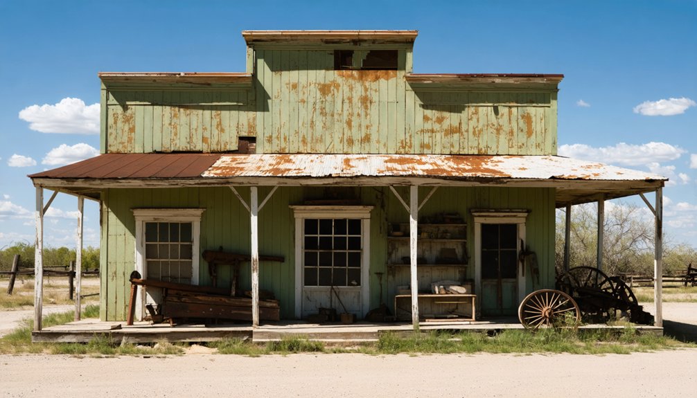
You’ll find Kelm’s ghost town remains three miles west of Emhouse, Texas, where Thomas R. Kelm founded this farming community in 1854. The town peaked at 400 residents in the 1890s, with a post office, schools, and churches along Cryer Creek. When the Trinity and Brazos Railway bypassed Kelm in 1907, residents relocated to nearby Emhouse. Today, aging newspaper clippings and local stories reveal the rich history of this abandoned settlement.
Key Takeaways
- Kelm, Texas became a ghost town by 1910 after the Trinity and Brazos Railway bypassed it, causing residents to relocate to Emhouse.
- Founded in 1854 by Thomas R. Kelm, the town reached its peak population of 400 residents during the 1890s.
- The town originally developed around Cryer Creek but relocated half a mile south during its most significant growth period.
- Key structures included Tinkle School, a colored school, multiple churches, and a post office established in 1894.
- Limited historical documentation exists, with most information coming from newspaper clippings, county records, and oral histories.
Origins and Settlement in 1854
Three key events marked the founding of Kelm, Texas in 1854: Thomas R. Kelm’s purchase of land ten miles northwest of Corsicana, the arrival of early settlers to establish a farming community, and the development of essential trade services around Cryer Creek.
You’ll find the original settlement about three miles west of present-day Emhouse, where farmers and tradespeople built their homes and agricultural infrastructure. The residents were paid with company scrip, similar to other company towns of that era.
The community’s growth remained modest but steady, reaching 400 residents by 1896. Local businesses included two grocery stores, a general store, and a cotton gin, while community cohesion centered around two churches and several schools, including Tinkle School. The town established a post office in 1894, marking its growing importance as a regional hub.
A separate school and church northwest of Kelm on Pruitt’s Ranch served the African American population, reflecting the area’s social diversity.
The Great Relocation of the 1890s
You’ll find Kelm’s greatest period of growth occurred during the 1890s when the community relocated half a mile south to take advantage of new transportation routes.
German settlers, part of the Adelsverein settlements, had established early roots in the region before Kelm’s move.
The move coincided with Texas’s broader population surge, as the state welcomed thousands of new settlers from the South and abroad. The expanding railroad network helped fuel this migration, stretching from 1,650 miles to nearly 10,000 miles by 1900.
Kelm’s strategic repositioning along these routes briefly transformed it from a modest farming settlement into a bustling waypoint for travelers and merchants.
Moving Half Mile South
During the late 1890s, Kelm’s residents undertook a remarkable community-wide relocation, moving their entire town half a mile south to position themselves along the bustling Cryer Creek – Corsicana road.
You can imagine the relocation challenges as buildings were physically transported rather than rebuilt from scratch, showcasing the community’s resilience and determination to thrive. Similar to the conditions faced by many during the era, some residents lived in rat-infested tenements while waiting for their homes to be relocated. Like the town of Bartonsite, most structures were relocated rather than abandoned.
The move proved beneficial for Kelm’s roughly 400 residents. By 1896, you’d have found a vibrant community with two churches, a grocery store, a cotton gin, and a general store.
The town’s post office, established in 1894, continued serving as an essential communication hub through the change.
Educational facilities also flourished, with both the Tinkle School and a separate colored school on Pruitt’s Ranch serving the area’s diverse population.
Community Growth Surge
Following its ambitious relocation along the Cryer Creek – Corsicana road, Kelm experienced a remarkable period of growth and development in the 1890s.
You’d have found a thriving community of 400 residents served by two churches, a grocery store, a cotton gin, and a general store.
The town’s educational significance was evident in its commitment to schooling, with the Tinkle School established on donated land and a separate school for the colored community northwest of town on Pruitt’s Ranch.
This dual education system, while reflecting the era’s segregation, demonstrated Kelm’s strong community identity through 1916.
The presence of multiple churches and schools created essential social centers, while the cotton gin and stores supported the town’s agricultural and commercial foundations.
Transportation Route Advantages
The 1890s relocation of Kelm capitalized on the evolving transportation landscape of late 19th century Texas.
You’ll find that Kelm’s strategic positioning took advantage of both established stagecoach routes and emerging railroad expansion, which were reshaping commerce across the state.
While many Texas communities struggled with poor road conditions and limited connectivity, Kelm’s new location placed it at the intersection of essential transportation corridors. The high cost of wagon transport at twenty cents per mile made rail access increasingly vital for town survival.
As stagecoach companies like C. Bain and Company maintained service to frontier areas, and railroads pushed westward between 1880 and 1883, Kelm’s site selection proved forward-thinking.
The town’s placement allowed it to benefit from the reliability of rail freight transport while still serving communities dependent on stage lines, effectively bridging the gap between old and new transportation networks. The transition was inevitable, as the arrival of railroads had already begun marking the decline of stagecoach operations across Texas.
Life Along Cryer Creek Road
Life along Cryer Creek Road centered around a vibrant rural community that flourished in the late 1800s, stretching approximately ten miles northwest of Corsicana in Navarro County.
You’d find the heart of rural lifestyle pulsing through interconnected settlements, where Cryer Creek got its name from the haunting sound of falling water resembling a woman’s cry. The town reached its peak when 200 residents called it home in 1892. Similar to many documented cases in the TXGenWeb database, local stories of hauntings and unexplained phenomena added to the area’s mystique.
- Your daily life revolved around steam cotton gins, gristmills, and general stores that processed the fruits of your labor.
- You’d send your children to the Tinkle School or the colored school on Pruitt’s Ranch.
- You’d gather at one of three churches that anchored community life.
- You’d experience mild winters and hot summers that shaped your farming calendar and social rhythms.
Agricultural Heritage and Trade
When Thomas R. Kelm purchased land in 1854, he set the foundation for what would become a thriving agricultural community.
You’ll find that by the 1890s, local agricultural practices had evolved from open-range cattle to settled farming, with cotton emerging as the dominant crop. The town’s cotton gin, established in 1896, became central to local trade networks.
The arrival of the Trinity and Brazos Railway in 1907 revolutionized Kelm’s agricultural economy. You could see how the railroad transformed shipping capabilities, connecting local farmers to broader markets from Waxahachie to Teague.
The town’s infrastructure, including general stores, churches, and schools, supported a diverse farming population of about 400 residents. Despite these developments, Kelm’s residents ultimately relocated closer to the railway at Emhouse, prioritizing better trade access.
From Bustling Town to Abandonment
Despite reaching its peak prosperity in the 1890s with a population of 400 residents, Kelm’s fate changed dramatically after 1907. The town’s historical significance diminished when the Trinity and Brazos Railway, known as the “Boll Weevil,” bypassed the original settlement.
This development altered the community dynamics as residents relocated 1.5 miles east to establish Emhouse, seeking better railway access.
- You’ll find the town’s decline reflected in the closure of its segregated schools by 1916.
- The post office, churches, and local businesses couldn’t survive the population shift.
- The agricultural economy that once supported the town couldn’t sustain itself.
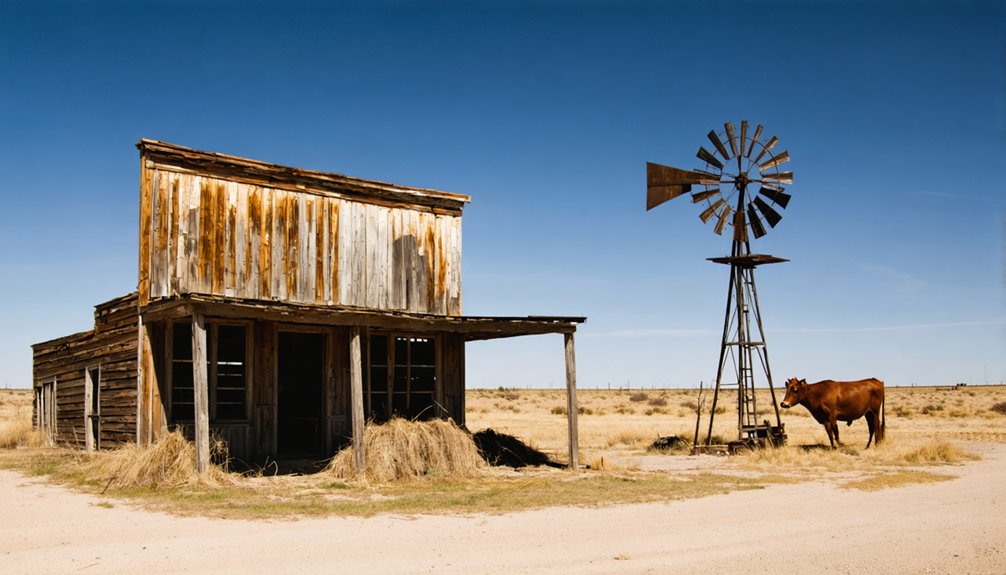
- By 1910, you’d see nothing but an abandoned townsite where a bustling community once thrived.
The transformation from vibrant town to ghost town took less than two decades, marking the end of Kelm’s brief but notable existence.
Preserving Kelm’s Historical Legacy

You’ll find scant written records documenting Kelm’s history, with most historical evidence coming from a handful of aging newspaper clippings and county records.
The preservation of local families’ oral histories and personal photographs has become essential to understanding Kelm’s past before these firsthand accounts are lost forever.
Community efforts to gather and properly archive these stories through organizations like Preservation Texas could help fill vital gaps in Kelm’s historical narrative.
Historical Records Remain Limited
The preservation of Kelm’s historical legacy faces significant challenges due to limited surviving records and documentation.
With historical scarcity affecting research efforts, you’ll find most information comes from scattered courthouse records and genealogy projects rather than extensive scholarly works.
The town’s rapid decline after 1907 and subsequent abandonment by 1910 have created substantial archival challenges for historians and researchers.
- No dedicated museums or preservation societies exist to maintain Kelm’s historical artifacts.
- Physical evidence of the original townsite remains largely undocumented.
- Available records rely heavily on county summaries and volunteer genealogist work.
- The town’s relocation to Emhouse disrupted the continuous documentation of its community history.
Understanding Kelm’s past requires piecing together fragments from courthouse archives, education records, and local historians’ contributions.
Local Stories Need Documentation
While historical records remain sparse, rich oral traditions and personal accounts from local families offer valuable insights into Kelm’s past.
Through community anecdotes, you’ll discover how residents adapted to the town’s relocation near the Trinity and Brazos Railway in 1907, and how daily life centered around two churches, a cotton gin, and local stores.
These stories paint a vivid picture of Kelm’s social fabric, including accounts of both the main school and the colored school on Pruitt’s Ranch.
You’ll find tales of the post office’s operations since 1894 and memories of community gatherings that shaped town life.
Local historians are now racing to document these precious oral traditions before they’re lost, as they’re essential to understanding Kelm’s transformation from a vibrant community to a ghost town by 1910.
Located approximately 10 miles northwest of Corsicana, Kelm emerged as a significant settlement in Navarro County‘s rural landscape during the late 1800s. The town’s geographic advantages included its proximity to Cryer Creek and position along early transportation routes, though these benefits shifted with changing infrastructure.
- Initially situated three miles west of present-day Emhouse, Kelm’s location proved strategic for early settlers and agricultural development.
- The town relocated twice, moving south in the 1890s and east in 1907, showcasing how transportation influence shaped settlement patterns.
- Kelm’s position near the Trinity and Brazos Railway’s new route in 1907 briefly sustained the community.
- The town’s final location, 1.5 miles east of its original site, represented the community’s attempt to adapt to changing economic patterns.
Environmental Impact on Settlement Patterns
Environmental factors played a decisive role in Kelm’s settlement patterns, particularly through water availability and resource management.
You’ll find that access to reliable water sources determined the town’s early development, much like other Texas settlements that faced water scarcity challenges in arid regions.
The town’s sustainability depended heavily on maintaining stable water tables for agriculture and daily life.
When environmental pressures mounted, you’d have seen how resource depletion affected the community’s ability to sustain its population.
Like many Texas ghost towns, Kelm’s fate was tied to its natural surroundings, where changes in water availability and resource accessibility could make or break a settlement.
The harsh climate and challenging topography typical of the region would’ve influenced everything from transportation routes to farming capabilities.
Frequently Asked Questions
What Was the Peak Population of Kelm During Its Most Prosperous Years?
You’ll find Kelm’s peak population reached 400 residents during the late 1890s, when its economy thrived with local businesses and before transportation changes forced the community closer to new railway lines.
Are There Any Remaining Buildings or Structures Still Standing in Kelm Today?
Like scattered fragments of a forgotten dream, you’ll find no remaining structures standing in Kelm today. Historical preservation efforts never took hold, leaving only bare earth where buildings once stood.
What Native American Tribes Originally Inhabited the Area Before Kelm’s Settlement?
You’ll find the Caddo and Hasinai tribes were the original inhabitants, with significant cultural significance in East Texas. Their tribal relations extended through established trade networks before European settlement began.
Did Any Notable Historical Figures or Events Originate From Kelm?
You won’t find historical significance through famous faces in Kelm – only Thomas R. Kelm, who bought the land in 1854, and Tinkle, who donated school land, stand out among notable residents.
What Happened to Kelm’s Residents When the Town Began Declining?
You’ll find most residents engaged in economic migration to Emhouse, about 1.5 miles east, following the railway development. Community dissolution happened gradually as families sought better opportunities near the Boll Weevil line.
References
- https://www.county.org/county-magazine-articles/summer-2025/ghost-towns
- https://mix941kmxj.com/see-how-two-texas-ghost-towns-battled-for-the-county-and-lost/
- https://www.chron.com/life/travel/article/ghost-towns-texas-18425049.php
- https://cedarbayoumarina.com/four-ghost-towns-under-lake-texoma/
- https://texashillcountry.com/hill-country-ghost-towns-explore/
- https://txnavarr.genealogyvillage.com/towns/kelm/index.htm
- https://freepages.history.rootsweb.com/~gtusa/usa/tx.htm
- https://www.youtube.com/watch?v=QGti1-zEjdo
- https://en.wikipedia.org/wiki/List_of_ghost_towns_in_Texas
- https://www.youtube.com/watch?v=phjUE19A8HM


