When you explore Lonerock, Oregon, you’ll discover a ghost town nestled against a distinctive rock formation that gave the settlement its name. Established in 1871, this pioneer community once thrived as an agricultural hub, peaking at 82 residents in 1930. Today, fewer than five residents maintain the remnants, including the historic 1898 Methodist-Episcopal Church and former schoolhouse. This isolated outpost’s authentic frontier atmosphere and untouched architecture tell a compelling story of Oregon’s past.
Key Takeaways
- Lonerock, Oregon is a remote ghost town founded in 1871, reaching its peak population of 82 in 1930 before declining.
- The town’s iconic Methodist-Episcopal Church from 1898 and a large solitary rock formation remain key landmarks.
- Economic challenges, isolation from railways, and harsh farming conditions led to Lonerock’s eventual abandonment by the 1970s.
- Visitors can explore well-preserved pioneer-era structures and experience authentic 19th-century rural Oregon architecture.
- Access is via dirt roads, with minimal tourism infrastructure, offering genuine ghost town atmosphere and opportunities for photography.
The Story Behind the Iconic Lone Rock
Standing prominently in the heart of Lonerock, Oregon, a 35-foot natural rock formation has served as the town’s namesake and most recognizable landmark since its earliest days.
You’ll find this distinctive Lone Rock near the historic Methodist church, where it continues to dominate the landscape as it has for generations.
The rock’s cultural significance runs deep in the community’s identity, influencing everything from the town’s original name to its postal designation.
More than just a geological formation, the lone rock shaped the very essence of the town’s existence and official recognition.
While the U.S. Postal Service eventually shortened the town’s name to “Lonerock,” the commanding presence of this natural monument remains unchanged.
Throughout the years, both residents and travelers have used this unmistakable formation as a navigational aid and gathering point, cementing its place as the enduring symbol of this remote Oregon settlement.
Like the Painted Hills nearby, this geological formation showcases the region’s rich natural history.
Located at an elevation of 2,835 feet, the massive rock formation stands as a testament to the rugged terrain that characterizes this part of Gilliam County.
Pioneer Settlement and Early Development
When pioneers first ventured into the Lonerock area in 1871, they discovered an ideal settlement site nestled in a valley with abundant grasslands and game-rich surrounding hills.
Like many early settler families such as the Barnard family settlers, who faced challenges establishing new communities in Oregon, these early settlers quickly established a service hub for surrounding ranches, laying the foundation for a growing community.
Despite pioneer struggles, these early settlers quickly established a service hub for surrounding ranches, laying the foundation for a growing community. Much like Battle Mountain State Park’s CCC building which served early visitors, the town’s structures supported the needs of its growing population.
You’ll find that Edward Wineland’s water-powered sawmill, built in 1874, marked a significant turning point in addressing settlement challenges.
The mill provided essential lumber for construction, while the establishment of a post office in 1875 connected the fledgling town to the wider region.
Life in a Frontier Agricultural Hub
As the heartbeat of regional agriculture, Lonerock’s economy revolved around wheat production, with local farms typically yielding 35 bushels per acre – though some achieved an impressive 60 bushels through nitrogen sulfate fertilization.
You’d find farmers selling their wheat for $4.50 to $5 per bushel, sometimes making under-the-table deals with local buyers. Farmers struggled with a mere 3% profit margin while facing substantial capital investments. Local researchers from the Agricultural Experiment Station provided critical guidance on improving crop yields and farming methods.
The farming lifestyle wasn’t just about profits – it defined the community’s identity. Crop innovations, from water-powered sawmills to mechanized harvesting, shaped the region’s development.
You’d face the challenges of dryland farming, where success hinged on rainfall patterns in the semi-arid climate. Despite hardships like the devastating 1955 drought and periodic fires, Lonerock’s agricultural services, roads, and rail access supported the surrounding ranches, making it an essential frontier hub.
Religious and Educational Legacy
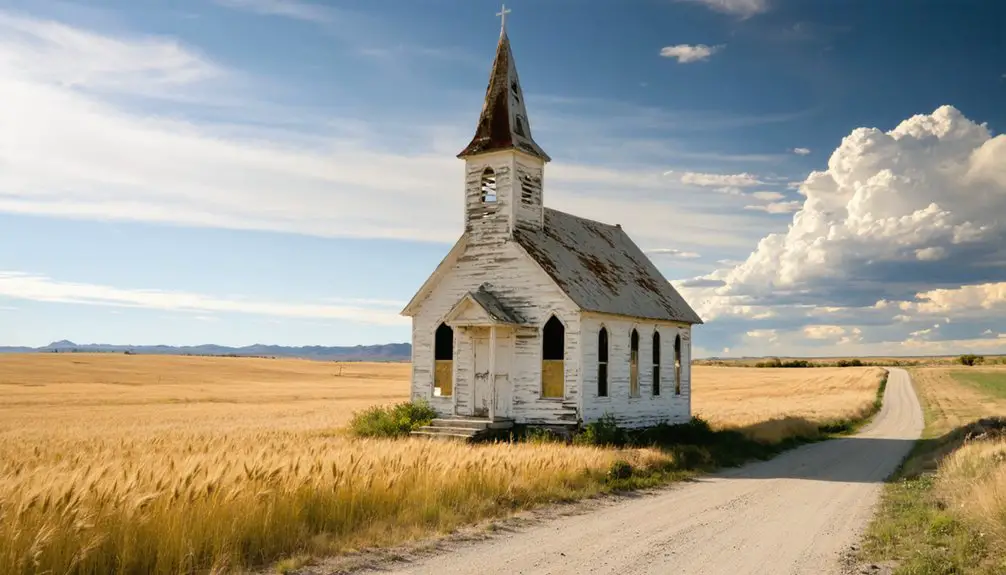
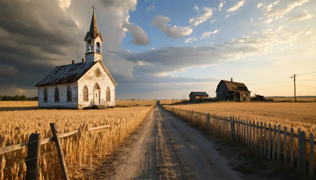
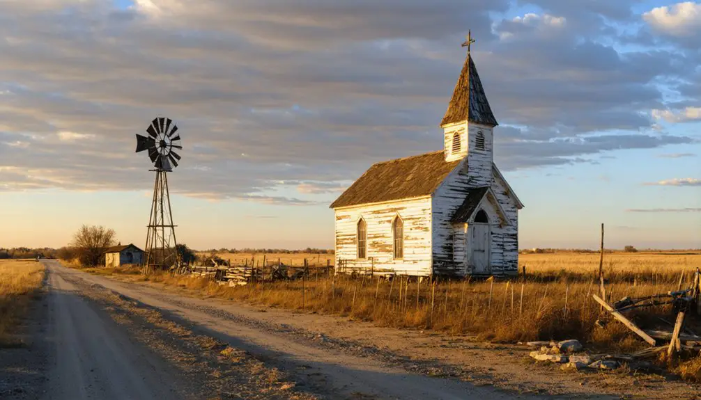
The Methodist-Episcopal Church, built beside Lonerock’s namesake 35-foot stone formation in 1898, anchored the town’s spiritual and social foundations for generations.
You’ll find evidence of faith based education in the tight relationship between the church and the two-story schoolhouse, where both institutions worked together to shape community values and literacy.
During Lonerock’s peak years, community gatherings flourished through Sunday services, seasonal celebrations, and shared use of facilities. When the town reached its highest recorded population of 82 in 1930, these institutions served as vital centers of community life.
The church influenced local education while the school supported religious activities, creating a dynamic hub of frontier culture. Located fifteen miles southeast of State Highway 206, the town’s position made it accessible for regional gatherings.
Though the population dwindled after 1930, leading to eventual closures, these historic structures still stand as symbols of the town’s commitment to learning and spirituality, preserved as landmarks in Oregon’s ghost town heritage.
Law Enforcement and Community Order
You’ll find few official records of law enforcement in Lonerock, though the town likely followed common patterns of rural Oregon settlements where county sheriffs provided occasional oversight.
The scattered population and remote location meant that community members primarily maintained order through informal means like neighborhood watches and dispute mediation by respected residents. With just 22 residents today, the tight-knit community continues this tradition of self-regulation. The historical practice of appointing the oldest resident as mayor helped maintain social order through respected leadership.
While any early jail construction remains undocumented, the town’s law enforcement needs were characteristically minimal, with serious matters handled by authorities from larger neighboring jurisdictions.
Early Jail Construction History
Law and order arrived in Lonerock during 1891 with construction of the town’s first wooden jail, marking a pivotal shift from informal frontier justice to structured community governance.
You’ll find this simple jail design reflected the town’s practical approach, using readily available wood in this remote location. The structure’s placement near central facilities emphasized its critical role in maintaining community order.
The jail’s construction came shortly after the town’s second school was built in 1888, showing how Lonerock was evolving from a basic settlement into an organized community.
The community impact was significant – this small but sturdy facility gave residents increased security and demonstrated their commitment to civic development, even in their isolated frontier location.
Local Sheriff’s Daily Operations
Building upon Lonerock’s early law enforcement foundations, modern sheriff’s operations have evolved into an extensive system of public safety and community protection.
You’ll find deputies conducting patrol operations across urban, rural, and waterfront areas, utilizing land, marine, and air assets to guarantee thorough coverage.
The sheriff’s office coordinates emergency response through a 24/7 dispatch center, managing everything from Level 3 evacuations during wildfires to search and rescue missions in Lonerock’s vast terrain.
Deputies oversee court security, prisoner transport, and process services while maintaining strong community connections through innovative out-of-custody programs.
Their work extends beyond traditional law enforcement, incorporating community service initiatives and rehabilitation programs that help maintain order while reducing jail populations and fostering trust between residents and law enforcement.
Community Policing and Order
While most modern towns maintain dedicated police forces, Lonerock’s approach to law enforcement reflected the informal, community-based methods typical of frontier settlements in Eastern Oregon.
You’ll find that residents relied heavily on community norms and mutual accountability rather than formal policing structures. The town’s remote location meant sheriff deputies could be hours away, so neighbors watched out for each other and handled minor disputes through town meetings or informal tribunals.
The church served as a central gathering place where social cohesion was strengthened through regular community events.
You’d see how the fear of damaged reputation in such a tight-knit society often deterred misconduct more effectively than official sanctions. When external threats arose, the town coordinated with county sheriffs, though their isolated location demanded self-reliance in most security matters.
Economic Rise and Transformation
You’ll find Lonerock’s early economic importance centered around its role as an agricultural hub, where the town’s strategic position along Lonerock Creek made it a natural service center for surrounding ranches.
The town’s position as a transportation crossroads in the 1870s brought steady traffic through the area, supporting local businesses and the water-powered sawmill that enabled construction growth.
Local commerce flourished during this period with the establishment of key infrastructure including a post office, jail, and Methodist-Episcopal Church, though the town’s inability to secure major railroad connections would later contribute to its decline.
Agricultural Hub Development
Following the arrival of settlers in 1871, Lonerock’s transformation into an agricultural hub began in a valley naturally suited for ranching and farming.
You’ll find that sustainable farming practices evolved from basic ranching to include innovative crop diversification, especially after Edward Wineland’s water-powered sawmill enabled expanded settlement in 1874.
The region’s agricultural prowess grew considerably with scientific advances and institutional support, particularly in wheat production where yields doubled to 60 bushels per acre.
- Oregon Agricultural Experiment Station provided essential research on crop varieties and farming methods
- Fertilizer adoption revolutionized farming efficiency despite initial skepticism
- Post-WWII mechanization and chemical advances boosted productivity
- Climate adaptation strategies enabled successful changes to hay production
These agricultural developments shaped Lonerock’s economic identity while preserving its independent spirit.
Transportation Crossroads Success
Three key factors established Lonerock as a crucial transportation hub in the 1870s and 1880s: its strategic location near Lonerock Creek, its position as a natural gathering point for ranchers, and its role as a service center for travelers moving through the valley.
You’d have found a thriving community supported by primitive roads that accommodated stagecoaches and freight wagons, while a water-powered sawmill helped maintain essential transportation routes and structures. The town’s facilities, including a jail, school, and church, served the steady flow of travelers and local agricultural traffic.
However, by World War I, Lonerock’s prominence began to fade. The lack of railroad connections and eventual bypass by major highways led to economic decline, transforming this once-bustling crossroads into a quiet reminder of changing transportation patterns.
Local Business Growth Period
While sheep farming initially dominated Lonerock’s economy in the 1870s, the community’s business landscape underwent significant transformation by the turn of the century.
You’ll find that Lonerock adapted to market demands, shifting toward cattle ranching and hay production as its economic foundation. The town’s business services expanded rapidly to support the growing agricultural sector, with community infrastructure developing to meet residents’ needs.
- A water-powered sawmill established in 1874 boosted local construction
- The post office’s arrival in 1875 strengthened commerce and communication
- Municipal government formation in 1882 provided stable administration
- Two-story school, jail, and Methodist-Episcopal Church served the social fabric
The Path to Abandonment
As Lonerock entered the 20th century with 68 residents, the seeds of its eventual abandonment were already taking root.
Despite showing early community resilience with growth to 82 residents by 1930, the town’s isolation from major transportation routes spelled trouble.
You’ll find that economic changes hit Lonerock particularly hard, as the Columbia Southern Railway’s distant location limited trade opportunities.
The 1970s marked a critical turning point when population plummeted to just 12 residents.
Things got even more complicated in the 1980s when a meditation commune briefly took control, renaming the town “Rash” – an episode that further destabilized the community.
Without proper infrastructure or economic drivers, Lonerock couldn’t retain its younger residents, joining the ranks of Oregon’s 200+ ghost towns.
Architectural Remnants and Ghost Town Appeal
Remnants of pioneer life stand preserved in Lonerock’s architectural landmarks, offering visitors a glimpse into Oregon’s frontier past.
You’ll discover the historical significance of the Methodist-Episcopal Church with its rustic 19th-century design, alongside the old jail and two-story schoolhouse that echo tales of frontier justice and rural education.
The town’s ghost town architecture, featuring weathered white clapboard exteriors, creates an authentic backdrop against the mysterious 35-foot Lone Rock formation.
- The church remains a central point for understanding early religious practices
- Scattered artifacts and household items reveal intimate details of past daily life
- Building remnants showcase typical pioneer construction methods
- Natural surroundings of canyon views and Robinette Creek enhance the remote atmosphere
The combination of historic structures and rugged landscape makes Lonerock an explorer’s paradise.
Historical Preservation Efforts
Despite the challenges of preserving a remote ghost town, dedicated local residents have spearheaded efforts to maintain Lonerock’s historical legacy since its population decline in the 1930s.
You’ll find grassroots initiatives focusing on key landmarks like the Methodist church, historic jail, and the town’s namesake 35-foot rock formation.
Community engagement has grown since the 2000s, with new residents joining longtime locals in preservation work.
While Gilliam County provides road maintenance and vandalism prevention, preservation challenges include limited funding, harsh weather conditions, and a small volunteer base.
The town’s inclusion in Oregon’s ghost town catalogs has helped secure occasional state support and heritage tourism interest.
ghost towns in oregon’s history present unique opportunities for exploration and education, drawing visitors who are intrigued by the stories of abandoned places. These sites often reflect the boom and bust cycles of the state’s past, providing a fascinating glimpse into the lives of those who once called these towns home. As awareness grows, more efforts are made to preserve the remaining structures and share their rich legacies with future generations.
Local historians collaborate with nearby communities to document and protect Lonerock’s pioneer-era structures, ensuring this slice of Eastern Oregon history isn’t lost to time.
Modern-Day Tourism and Heritage
Today’s visitors to Lonerock encounter a remarkably authentic ghost town experience, characterized by profound quiet and rustic isolation.
You’ll find this heritage tourism destination accessible mainly by dirt roads, offering a genuine glimpse into late 19th-century rural Oregon life. The town’s cultural significance remains preserved in its historic church, converted schoolhouse, and the iconic lone rock formation that gave the town its name.
- Self-guided exploration of well-maintained streets and Western architecture
- Natural soundscapes dominate the environment with minimal vehicle traffic
- No commercial amenities – prepare for an off-grid adventure
- Historic buildings serve as tangible connections to frontier settlement patterns
While tourism infrastructure is minimal, Lonerock’s authentic charm lies in its untouched nature and profound sense of solitude, perfect for those seeking an undiluted glimpse into Oregon’s past.
Frequently Asked Questions
Are There Any Living Descendants of Original Lonerock Settlers Still in Oregon?
While descendant stories and family ties likely exist somewhere in Oregon, you can’t definitively confirm living descendants of original Lonerock settlers without conducting extensive genealogical research through regional historical societies.
What Was the Highest Recorded Population of Lonerock During Its Peak?
Looking at Lonerock demographics and ghost town history, you’ll find that its highest recorded population peaked at 82 residents in 1930, before the town’s gradual decline into its current near-ghost town status.
Did Any Notable Historical Figures Ever Visit or Stay in Lonerock?
You won’t find any famous visitors or historical anecdotes about notable figures staying in Lonerock. Records show it remained a simple agricultural crossroads town without documented visits from prominent personalities.
Were There Any Significant Natural Disasters That Affected Lonerock’s Development?
Like a fierce guardian, the 2024 Lone Rock Fire was your area’s most significant natural disaster, burning 131,000 acres near Lonerock. This wildfire’s development impact echoes historical fires that challenged settlement.
What Native American Tribes Originally Inhabited the Area Before Lonerock’s Settlement?
You’ll find the area was home to several Indigenous cultures, including the Wasco, Warm Springs, Umatilla, and Northern Paiute tribes, whose tribal history involved seasonal migrations through these lands for fishing and gathering.
References
- https://traveloregon.com/things-to-do/culture-history/ghost-towns/lonerock/
- https://www.deviantart.com/austinsptd1996/journal/Six-Iconic-Ghost-Towns-Within-Oregon-1109696435
- https://en.wikipedia.org/wiki/List_of_ghost_towns_in_Oregon
- https://lagrandeobserver.com/2007/05/18/the-past-hangs-on-at-lonerock/
- https://www.ghosttowngallery.com/htme/lonerock.htm
- https://kids.kiddle.co/Lonerock
- https://en.wikipedia.org/wiki/Lonerock
- https://visiteasternoregon.com/poi/lonerock-2/
- https://www.salemhistory.net/digital/collection/max/id/3435/
- https://traveloregon.com/things-to-do/outdoor-recreation/bicycling/lone-rock-loop/


