You’ll find the ghost town of Merle along Bethel Creek in southeastern Burleson County, Texas, where scattered ruins mark a once-thriving farming community established in the 1830s. The town flourished through cotton, sugar, and cattle production until the early 1900s, when the railroad’s bypass and rural-to-urban migration led to its decline. Today, deteriorating structures like the W.W. Cole Building and Hicks-Cobb store stand behind private fences, while a historic cemetery holds stories of its pioneer past.
Key Takeaways
- Merle was established along Bethel Creek in southeastern Burleson County, Texas, where early settlers were drawn to fertile soil and water access.
- The town’s economy relied on agriculture, including cotton, sugar, corn, and cattle ranching during the late 19th century.
- Merle’s decline began when the railroad bypassed the town, severely limiting transportation access for farmers and businesses.
- Current remains include deteriorating foundations, the W.W. Cole Building, Hicks-Cobb general store, and a cemetery with 19th-century headstones.
- Most historic structures are on private property behind “No Trespassing” signs, with no formal tours or visitor facilities available.
A Lost Town on Bethel Creek
Nestled along the south bank of Bethel Creek, the ghost town of Merle once stood approximately three miles south of present-day Snook in southeastern Burleson County, Texas.
The settlement’s location exemplified typical settlement patterns of late 19th-century Texas, where access to water sources proved essential for agriculture and daily life. The region’s fertile Brazos bottoms supported the agricultural endeavors of early settlers. Like the miners of Thurber, residents faced economic hardships when regional market conditions shifted. You’ll find the surrounding countryside remains largely unchanged, maintaining its rural character and sparse population density that defined the original community dynamics.
Today, Merle’s geographic isolation tells the story of its eventual decline. The town’s position, while advantageous for early agricultural pursuits, couldn’t overcome the absence of critical transportation links.
Without railroad connections or major roads, the settlement gradually lost its foothold, transforming from a close-knit farming community into one of Texas’s many forgotten places.
Early Settlement and Pioneer Life
The first Anglo-American settlers reached the Merle area in the early 1830s, drawn by the rich blackland prairie soil and abundant water sources that would shape the region’s agricultural destiny.
Rich prairie soil and plentiful water drew pioneering Anglo-American settlers to Merle’s promising lands in the 1830s.
You’d find these hardy pioneers establishing scattered homesteads, building simple wood and adobe structures using local materials, and carving out a living through farming, ranching, and small-scale trading. Like the settlers at Plemons Crossing, they relied heavily on finding safe river passages to transport goods and supplies.
Pioneer challenges were relentless – from harsh weather and isolation to limited access to supplies and medical care. The area faced similar hardships to those that created many of Texas’ 511 ghost towns.
You’d see families banding together, sharing resources, and creating cultural traditions through communal gatherings like barn-raisings and harvest celebrations.
Despite primitive conditions, they’d meet for religious services and informal education, blending their Anglo-American heritage with Native American and Mexican influences that characterized Texas frontier life.
Agricultural Heritage and Local Economy
As agricultural development took root in Merle during the late 19th century, you’d find a diverse farming economy emerging around cotton, sugar, corn, and hay production.
Smart farmers practiced crop rotation, adding potatoes, spinach, and cabbage to maintain soil health. When boll weevils devastated cotton crops, many farmers adapted by diversifying their operations. Similar to the Haggard Farm’s experience, large guard dogs were initially used to protect livestock from predators.
You’d notice a significant shift as cattle raising replaced the old plantation system after the Civil War. Local ranchers strengthened their herds by introducing Brahman cattle, while innovative livestock diversification brought sheep and even llamas as protective guardians. The county’s subtropical humid climate supported year-round grazing for livestock.
Czech immigrants in the 1880s and Italian farmers in the 1890s brought new farming techniques that helped small-scale operations thrive.
Daily Life in Rural Burleson County
Life in rural Burleson County centered around religious congregations and small community hubs that shaped daily routines and social bonds. You’d find your daily activities structured around central gathering spots like the First United Methodist Church of Caldwell and local businesses such as Chance Brothers grocery store, where community gatherings were common.
Your typical rural experience would include:
- Working the land through farming or tenant labor, supported by skilled trades like saddlery
- Participating in community efforts like flood management and levee construction
- Attending church services and social functions at established congregations, which served as essential connection points
The average annual rainfall of 37 inches made the area particularly suitable for agricultural activities and sustainable farming practices.
You’d live close to agricultural lands and waterways, often in homes like the Renfro-Clark residence, balancing the need for fertile soil against flood risks while maintaining strong multigenerational ties through family plots and community cemeteries. Religious life was deeply influenced by leaders like Henry Renfro, who established the Bethesda Baptist Church and shaped the spiritual landscape of the region.
The Slow Fade Into History
When you examine Merle’s gradual decline in the early 1900s, you’ll find a textbook example of rural-to-urban migration patterns that affected many Texas farming communities.
Like the town of Ayr, the railroad bypassed Merle, eliminating crucial transportation access for local farmers and businesses.
The devastating impact of natural disasters on communities was evident in cases like Indianola, which faced complete abandonment after major hurricanes.
You can trace how younger residents left for bigger cities seeking education and jobs, while remaining farmers struggled with crop price fluctuations and agricultural challenges.
The town’s inability to maintain its population ultimately led to the closure of schools, churches, and businesses, creating a downward spiral that transformed Merle from a vibrant rural community into an abandoned settlement.
Rural Migration Patterns
Throughout the mid-20th century, Merle’s population steadily dwindled due to powerful economic and social forces that reshaped rural Texas. The rural exodus reflected broader patterns of urban migration across the region, as young residents sought better opportunities in growing cities. Transportation improvements, particularly new highways bypassing smaller settlements, accelerated this transformation.
Key factors driving Merle’s declining population included:
- Mechanization of agriculture reducing local labor needs
- Young people relocating for industrial and service sector jobs
- Loss of essential services like schools and stores
You’ll find this pattern repeated across Texas ghost towns, where economic shifts and improved mobility enabled mass movement to urban centers.
As agricultural communities lost their workforce, remaining residents – often elderly – couldn’t sustain local institutions, leading to further decline.
Agricultural Community Decline
Despite initial resilience in the early 1900s, Merle’s agricultural foundation crumbled under a perfect storm of environmental disasters and economic pressures.
You’ll find the town’s decline traced through devastating droughts of 1916-17 and 1950-57, followed by destructive floods that caused $120 million in damages.
Despite attempts at agricultural innovation, the community’s farming base couldn’t withstand the combined assault of the Dust Bowl, Great Depression, and ongoing water supply challenges.
The shift to mechanized cotton production and large-scale ranching operations dealt another blow to community resilience.
You can see how the consolidation of smaller farms into vast commercial operations emptied the countryside, culminating in the closure of Merle’s post office in 1919.
The transformation from diversified farming to industrial agriculture ultimately sealed the town’s fate.
What Remains Today
Today you’ll find little more than scattered foundations and deteriorating ruins at the former site of Merle, Texas.
Access to the ghost town requires careful navigation through private lands, as most remaining structures sit on parcels now owned by ranchers or individual property holders.
Historical artifacts and building remnants, while protected by Texas preservation laws, continue to weather under harsh environmental conditions, leaving fewer traces of the town’s existence with each passing year.
Physical Site Conditions
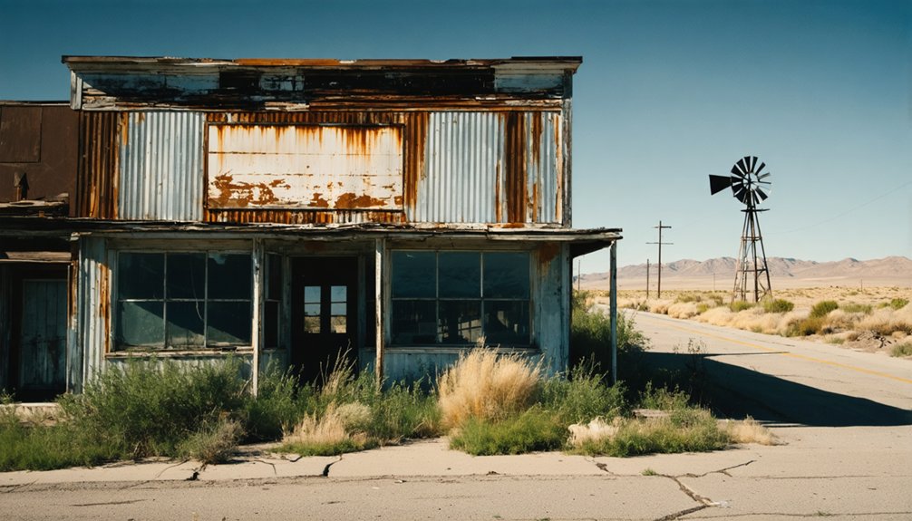
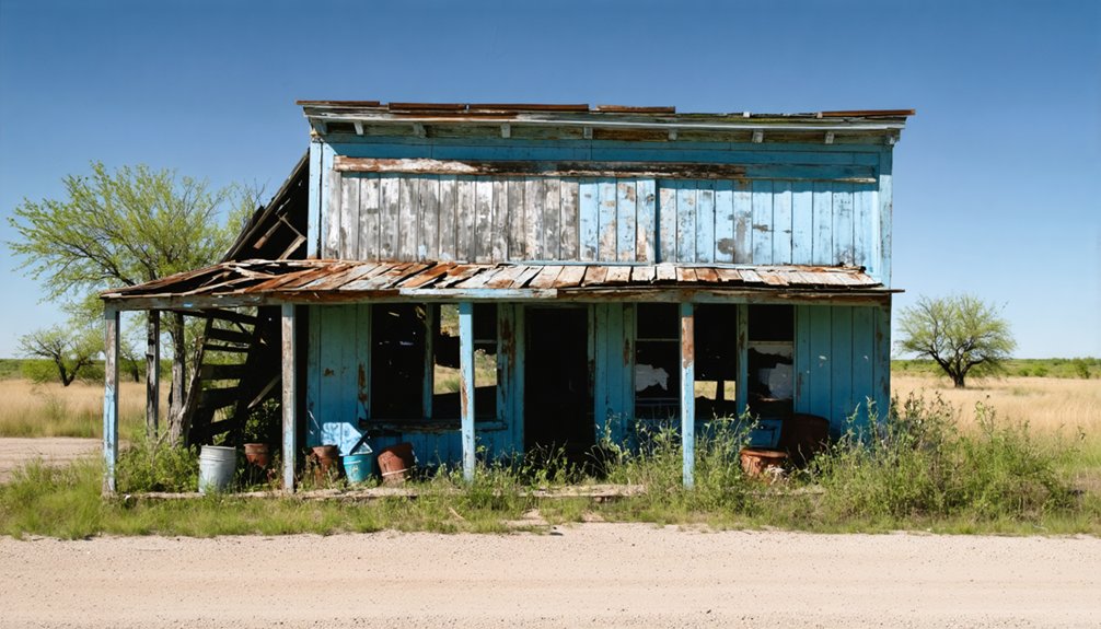
While time has taken its toll on Merle’s structures, several significant buildings still stand as silent witnesses to the town’s past. You’ll find structural decay evident throughout the site, with many buildings showing extensive weathering and missing roofs.
The W.W. Cole Building and Hicks-Cobb general store remain the most intact, though they’re battling persistent site deterioration from harsh Texas weather.
Key features you can still explore include:
- A small fishing marina with visible remains along the waterfront
- The town cemetery with legible headstones dating to the late 19th century
- The former post office and gas station with its rusted pumps
Natural reclamation is ongoing, with vegetation steadily encroaching on foundations and buildings, while wildlife has made homes in the abandoned structures.
Historical Site Access
Accessing Merle’s historic remnants comes with significant restrictions designed to protect both visitors and the site itself.
You’ll find most structures behind fences marked with “No Trespassing” signs, limiting ghost town preservation efforts and visitor engagement to exterior viewing only. No sanctioned interior tours are available due to safety concerns.
While you can observe foundational ruins, partial walls, and mining equipment from designated areas, you’ll need to respect private property boundaries, as some residents still live in nearby areas like Shafter.
The site lacks formal visitor facilities or guided tours, leaving exploration largely self-guided. Without official markers or interpretive signage, your experience relies on personal observation of the remaining structures and mining remnants that hint at Merle’s industrial past.
Lessons From Lost Texas Communities
Throughout Texas history, ghost towns serve as compelling case studies of how communities rise and fall based on specific vulnerabilities.
Among the well-known ghost towns in Texas, some were once bustling centers of commerce, while others emerged due to the discovery of oil or minerals. Today, these remnants of the past attract adventurers and historians alike, offering a glimpse into the lives of those who once called them home. Exploring these abandoned places provides a unique opportunity to reflect on the transient nature of prosperity and community.
When you examine these lost settlements, you’ll find essential lessons about community resilience and economic adaptation that remain relevant today.
Key insights from Texas ghost towns include:
- Single-industry dependence proved fatal – towns relying solely on mining, cotton, or coal couldn’t survive market shifts.
- Transportation access determined survival – communities bypassed by new highways or abandoned rail lines quickly declined.
- Political status mattered enormously – losing county seat designations often triggered rapid population loss.
You’ll notice that towns that successfully diversified their economies, like Gruene’s shift to tourism, demonstrated the vital importance of adapting to changing circumstances rather than remaining locked into outdated economic models.
Frequently Asked Questions
Were There Any Significant Natural Disasters That Contributed to Merle’s Decline?
You won’t find natural disasters behind Merle’s decline – historical records show economic decline was the culprit, following patterns similar to other Texas ghost towns that faded due to resource depletion.
What Was the Primary Religion or Church Denomination in Merle?
While there’s no definitive record, you’ll find Protestant influence was likely dominant, with Baptist or Methodist denominations being most common for religious practices in small Texas frontier towns like this.
Did Any Notable Historical Figures Ever Visit or Live in Merle?
Perusing past papers proves there’s no record of famous visitors or notable residents in this remote location. You won’t find historical landmarks commemorating any distinguished guests who might have passed through.
What Was the Average Land Price for Farmland Around Merle?
You’ll find farmland near Merle reflects current Austin-Waco-Hill Country land values at $7,291 per acre, following regional agricultural trends, though prices have slightly cooled from mid-2024’s peak market values.
Were There Any Documented Conflicts Between Settlers and Native Americans?
While you’ll find extensive records of settler conflicts throughout Texas, there’s no specific documentation of Native relations or violent encounters in Merle’s immediate vicinity during its brief settlement period.
References
- https://en.wikipedia.org/wiki/Marilee
- https://mix941kmxj.com/the-strange-sad-story-of-a-texas-ghost-town-youll-never-visit/
- https://jamesbigleyranches.com/general/texas-ghost-towns/
- https://www.tshaonline.org/handbook/entries/merle-tx
- https://texashighways.com/travel-news/four-texas-ghost-towns/
- https://www.southernthing.com/ruins-in-texas-2640914879.html
- https://www.youtube.com/watch?v=T7hj1iweWi8
- https://en.wikipedia.org/wiki/List_of_ghost_towns_in_Texas
- https://roadsidethoughts.com/tx/merle-xx-burleson-profile.htm
- https://www.texasescapes.com/TexasHillCountryTowns/Merrilltown-Texas.htm


