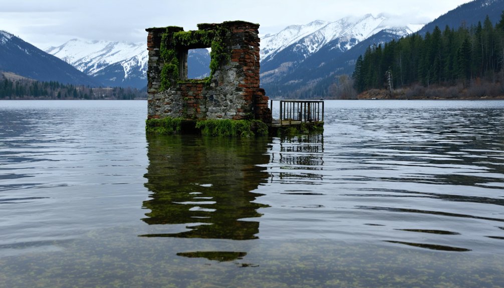
America’s reservoir system has submerged over 100 towns during the 20th century, creating underwater ghost towns across the nation. You’ll find notable examples in TVA projects like Butler (Tennessee), Massachusetts’ Quabbin Reservoir (Dana, Enfield), and Lake Texoma (Hagerman, Preston). During drought conditions, water levels often drop, revealing foundations, streets, and artifacts from these displaced communities. These periodic exposures offer rare archaeological windows into communities sacrificed for infrastructure development.
Key Takeaways
- Drought conditions periodically reveal submerged towns like Butler and Hagerman, offering limited opportunities to explore historical remnants firsthand.
- Visitors can view underwater ghost towns through transparent-bottom boats, diving expeditions, or shoreline observation during low water levels.
- Historical markers along reservoir edges provide context about communities displaced by dam projects throughout the Tennessee Valley and beyond.
- Annual commemorative events like Old Butler Days connect visitors with the cultural heritage of communities lost to reservoir creation.
- Archaeological surveys document artifacts from submerged sites, though visitors should observe but never remove items from exposed ruins.
Tennessee Valley Authority’s Submerged Legacy: Towns Beneath Southern Lakes

When the Tennessee Valley Authority (TVA) established operations in 1933, it initiated a massive regional transformation that would permanently alter the landscape of the American South. The agency’s dam construction submerged numerous communities beneath artificially created reservoirs, effectively erasing their physical presence from the map.
TVA history reveals a calculated sacrifice of small towns like Loyston (1935), Butler (1948), and Proctor (1940s) for flood control and hydroelectric power generation. The agency’s documentation, including Lewis Wickes Hine’s 1933 photographs, preserves evidence of these submerged identities.
Data indicates significant displacement: Butler’s relocation alone involved moving 12 homes, 50 businesses, and nearly 1,300 graves. While the dams prevented annual flooding and generated electricity, they simultaneously dismantled community structures and disrupted generational connections to place, creating an underwater landscape of forgotten towns accessible only through archives and memory. The initiative, part of FDR’s New Deal, was designed to provide jobs and hydroelectric power during the Great Depression while addressing devastating regional floods. An annual Old Butler Days festival in August commemorates the submerged town’s history, allowing former residents and descendants to maintain their connection to the past.
The Quabbin Reservoir Story: Massachusetts Communities Sacrificed for Boston’s Water
Unlike the TVA projects in the South, Boston’s expanding water demands in the early 20th century necessitated the creation of the Quabbin Reservoir through legislative action codified in Chapter 375 of the Acts of 1926.
This massive water infrastructure project permanently altered Massachusetts’ geography and displaced thousands.
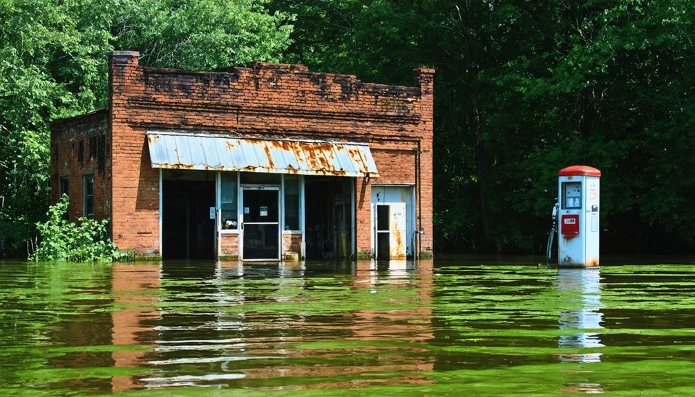
The changes led to the creation of ghost towns along American rivers, where vibrant communities once thrived. Abandoned buildings and rusted equipment are all that remain, telling stories of a bygone era when these towns flourished. As nature gradually reclaims these areas, it’s a stark reminder of the impact of human intervention on the landscape.
Analysis of the sacrificed communities reveals:
- Four towns (Dana, Enfield, Greenwich, Prescott) were legally dissolved on April 28, 1938
- Approximately 2,500 residents were forcibly relocated
- 7,500 graves were exhumed and reinterred elsewhere
- 400 billion gallons of capacity was achieved by 1946
You’re witnessing the results of a utilitarian calculation: Boston’s metropolitan thirst versus rural autonomy.
The 75,000-acre protected watershed now serves over three million residents, representing a permanent transformation of sovereignty from disincorporated municipalities to centralized water management authority. The project faced significant opposition, including a formal lawsuit from Connecticut concerned about downstream water rights. The contentious debate over the Swift River dam proposal lasted six years before implementation, highlighting the complex intersection of urban conservation needs and rural community identities.
From Homes to Hydropower: Pacific Northwest’s Drowned Settlements
Throughout the Pacific Northwest, the mid-20th century hydroelectric boom transformed entire communities into underwater ruins, submerging 11 towns beneath Grand Coulee Dam’s waters alone.
You’ll find comparable losses at Brownlee Reservoir and Lookout Point Dam, where settlements like Landax and Signal vanished permanently from Oregon’s landscape.
The ecological impact extended beyond infrastructure—Celilo Falls’ submersion eliminated vital Indigenous fisheries, severing centuries-old cultural heritage connections.
Quantitative analysis reveals extensive agricultural displacement, with established orchards and tribal lands sacrificed for reservoir creation.
Human resistance manifested in various forms: Hugh Lord of Saint Thomas refused evacuation until water reached his foundation, while some Grand Coulee residents secured extensions during final phases.
The data consistently demonstrates a pattern of community fragmentation—partial buyouts creating diminished settlements lacking their original social fabric, despite structured relocation attempts. Like in North Dakota, the creation of New Town in 1954 resulted from the Garrison Dam construction, which forced over 325 families to relocate from their original homes.
These patterns mirror Oregon’s Bayocean, where ignoring indigenous warnings about the spit’s instability led to a resort town that completely fell into the sea by 1971.
Appalachian Valleys Transformed: The Human Cost of Eastern Reservoir Projects
Despite vocal community opposition, the proposed Blue Ridge Project represented one of the most extensive forced displacement initiatives in Appalachia’s dam-building era, targeting 27,900 acres of Grayson County farmland for inundation.
The economic impact would have devastated regional communities, with projected annual losses of $13,500,000 against inadequate compensation of $5,000,000.
The project’s economic calculus revealed a staggering $8.5 million annual shortfall, prioritizing external interests over community sustainability.
Community displacement statistics reveal the project’s true scope:
- 2,700 residents forced from ancestral lands
- 893 homes scheduled for destruction
- 15 churches and 12 cemeteries requiring relocation
- 5 post offices and 10 industrial employers facing elimination
The project was halted when President Ford signed legislation in 1976 designating 26.5 miles as a National Wild and Scenic River.
You’d witness ecological degradation similar to Smith Mountain Lake’s precedent, where drawdowns created half-mile mudflat rings and silt accumulation threatened long-term viability.
Within fifty years, sedimentation would render the reservoirs functionally obsolete, permanently altering the Appalachian landscape without sustainable economic alternatives.
Recent catastrophic flooding has demonstrated how the region’s strip mining history has exacerbated environmental vulnerabilities by creating thinner soil layers that cannot absorb heavy rainfall.
When Rivers Rose: The Lost Towns of Lake Texoma and the American Southwest
The inundation narratives of Appalachia find their parallel in the American Southwest, where Lake Texoma stands as one of the nation’s largest man-made reservoirs. Completed in 1944, Denison Dam submerged 83,000 acres across Texas and Oklahoma, sacrificing towns like Hagerman, Preston, Cedar Mills, Woodville, and Aylesworth to ostensibly serve flood control and commerce.
You’ll find submerged histories revealed during drought conditions—foundations, gravestones, and artifacts from communities once 500 strong, now accessible only when waters recede. The severe drought in Texas has exposed numerous historical sites including the grave of Johnny C. Parks that remained underwater for decades. During periods of low water, visitors can see the remaining church and cemetery of Hagerman that somehow survived above water level.
The archaeological discoveries remain largely unexplored; surveys before flooding documented potsherds and stone tools, but most prehistoric evidence lies underwater.
Similar reservoirs across the Southwest have created a pattern of submerged cultural heritage sites, with drought now exposing century-old churches and Native American artifacts to both historians and looters alike.
Frequently Asked Questions
Can Tourists Dive to Explore Submerged Structures in These Reservoir Towns?
You can access submerged history through underwater exploration at specific reservoirs, but technical diving certification, permits, and guided tours are typically required due to safety hazards and preservation regulations.
What Compensation Did Displaced Residents Receive for Their Lost Properties?
You’d think property valuation would’ve been generous, but compensation varied widely—from $1.5M settlements in Nags Head to partial payments based on insurance claims and Fifth Amendment takings litigation success rates.
Are There Any Legal Battles Still Ongoing Over These Flooded Lands?
Yes, legal disputes persist in the Columbia River Basin, with tribal nations and environmental groups challenging federal dam operations. Land ownership conflicts continue as regulatory shifts threaten wetlands protection under the Clean Water Act.
How Did Flooding Impact Native American Archaeological Sites and Cultural Heritage?
Like a digital catastrophe, flooding submerged 60-70% of archaeological preservation sites, eroding cultural significance through wave action, displacing tribes, and severing contextual relationships. You’ll find exposed artifacts now face vandalism risks.
What Ecological Changes Resulted From Converting Valleys Into Artificial Lakes?
You’ll observe significant ecosystem diversity reduction through habitat alteration, with 100% terrestrial species displacement, riparian transformation, and hydrological regime shifts favoring generalist aquatic species while eliminating native terrestrial communities.
References
- https://www.tnmagazine.org/tennessees-underwater-ghost-towns/
- https://www.traceyourpast.com/newsletters/ghost-towns
- https://www.thewanderingappalachian.com/post/the-underwater-towns-of-appalachia
- https://cedarbayoumarina.com/four-ghost-towns-under-lake-texoma/
- https://en.wikipedia.org/wiki/List_of_flooded_towns_in_the_United_States
- https://www.neh.gov/article/atlas-drowned-towns
- https://www.youtube.com/watch?v=YT8a1HbiyNI
- https://www.thesmokies.com/underwater-ghost-towns/
- https://www.youtube.com/watch?v=wM7jS4r4SDE
- https://en.wikipedia.org/wiki/Quabbin_Reservoir