You’ll find Massachusetts harbors several documented ghost towns, each with distinct historical circumstances behind their abandonment. Dogtown, established in the 1600s near Gloucester, deteriorated into vagrant territory after the War of 1812. The Swift River Valley’s four towns—Prescott, Dana, Enfield, and Greenwich—were deliberately disincorporated in 1938 and flooded to create the Quabbin Reservoir, displacing over 7,500 bodies from their graves. Stone walls, cellar holes, and the Prescott Peninsula still mark where these communities once thrived before Massachusetts prioritized Boston’s water supply over rural settlement.
Key Takeaways
- Dogtown, established in the 1600s near Gloucester, was abandoned after the War of 1812 and became home to outcasts and vagrants.
- Prescott, Dana, Enfield, and Greenwich were disincorporated in 1938 to create the Quabbin Reservoir for Boston’s water supply.
- The four Swift River Valley towns required relocating over 7,500 bodies and demolishing all buildings before flooding the reservoir.
- Prescott Peninsula remains above water as a wildlife sanctuary, with visible cellar holes and stone walls from the former town.
- The Swift River Valley Historical Society preserves the history and hosts annual reunions for descendants of the displaced residents.
Dogtown: From Thriving Settlement to Wild Dog Territory
In the early 1600s, settlers established what would become Dogtown as a parish of Gloucester, choosing the rocky inland highland—spanning roughly five square miles—for its strategic distance from coastal threats. You’ll find evidence of 80 families who once inhabited this Commons Settlement, preferring livestock to crops on the poor soil.
After the Revolutionary War and War of 1812 eliminated pirate dangers, residents abandoned the area for harbor communities. By 1814, only six houses remained standing. The settlement’s decline attracted vagrants, suspected participants in witch trials, and societal outcasts. Packs of dogs—kept for protection or left behind—gave the ghost town its enduring name.
Finnish quarry workers later numbered 40 cellar holes, documenting the original dwellings before the last structure disappeared in 1845.
Prescott and the Quabbin Reservoir Project
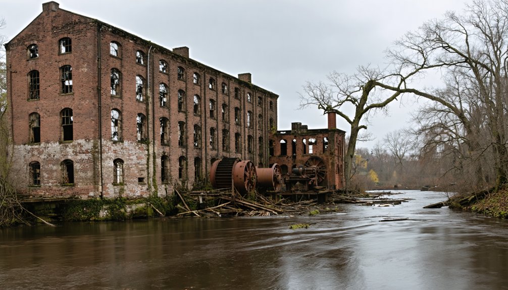
You’ll find Prescott’s story in the Swift River Valley, where it stood as one of four Massachusetts towns—alongside Dana, Enfield, and Greenwich—disincorporated on April 28, 1938, to create the Quabbin Reservoir for Boston’s water supply.
The project required demolishing every building, removing trees, and relocating over 7,500 bodies from cemeteries before flooding began in mid-August 1939.
Today, only the Prescott Peninsula remains above water as a wildlife sanctuary, while cellar holes, stone walls, and abandoned roads mark where nearly 400 residents once called home.
Swift River Valley Settlement
The Swift River Valley once cradled four distinct Massachusetts communities—Prescott, Greenwich, Enfield, and Dana—each with roots stretching back to colonial land grants and Indigenous settlements. You’ll find the valley’s history begins with Nipmuc land use, where “Quabbin” meant “meeting of many waters” at the convergence of Swift River branches.
King Philip’s War disrupted these communities, triggering colonial resettlement through veteran land grants like Quavin Township. Greenwich emerged as the valley’s oldest European settlement in 1754, from which Enfield broke away in 1816.
Disincorporation and Reservoir Flooding
Among these four valley communities, Prescott held the distinction of being the smallest and most rural when Boston’s demand for water sealed its fate. The Prescott town characteristics—three small villages housing barely 300 residents by 1900—made it politically vulnerable when state planners identified the Swift River Valley for reservoir development.
Reasons for disincorporation centered on metropolitan water needs:
- State Legislature voted condemnation in 1927
- Town ceded self-governance to Massachusetts in 1928
- Formal dissolution occurred April 28, 1938, at midnight
You’ll find most of Prescott’s land remained above water as the restricted-access Prescott Peninsula. The state moved or demolished homes, leaving cellar holes as archaeological traces. Today, New Salem and Petersham absorbed the former town’s territory, splitting it between Franklin and Worcester Counties.
Four Lost Towns Legacy
When Massachusetts legislators voted to condemn the Swift River Valley in 1927, they set in motion the dissolution of four complete municipalities—Prescott, Dana, Enfield, and Greenwich—whose combined histories stretched back over a century.
You’ll find the impact of Prescott’s depopulation on the broader region reflected in stark numbers: between 1850 and 1890, these towns lost over a third of their residents as farming declined and industries relocated.
Today, Massachusetts counts 351 municipalities instead of 355. The society’s efforts to preserve Prescott’s history continue through the Swift River Valley Historical Society, founded in 1936, which maintains collections in the Whitaker-Clary House and relocated Prescott’s 1837 church to New Salem.
Annual reunions on Dana Common’s third Sunday in July unite descendants of over 2,000 displaced residents.
Catamount: A Remote Village Lost to Time
Perched high in the mountainous terrain of Colrain, Massachusetts, Catamount emerged as a farming settlement in the mid-1700s or early 1800s, predating much of the surrounding modern development. The community claimed a unique distinction in 1812 when it became the first town to fly the United States flag over its schoolhouse—a stone marker still commemorates this site.
However, the same remote location that offered isolation eventually sealed Catamount’s fate. By the early 20th century, treacherous terrain and deteriorating infrastructure forced complete abandonment. The Commonwealth purchased the land in 1967, transforming it into Catamount State Forest, which now provides:
- Native wildlife habitat preservation
- Modern recreation opportunities for hikers
- Historical exploration accessible only by foot
You’ll find roads closed to vehicles, leaving nature to reclaim this mountain settlement.
Davis: The Rise and Fall of a Mining Community
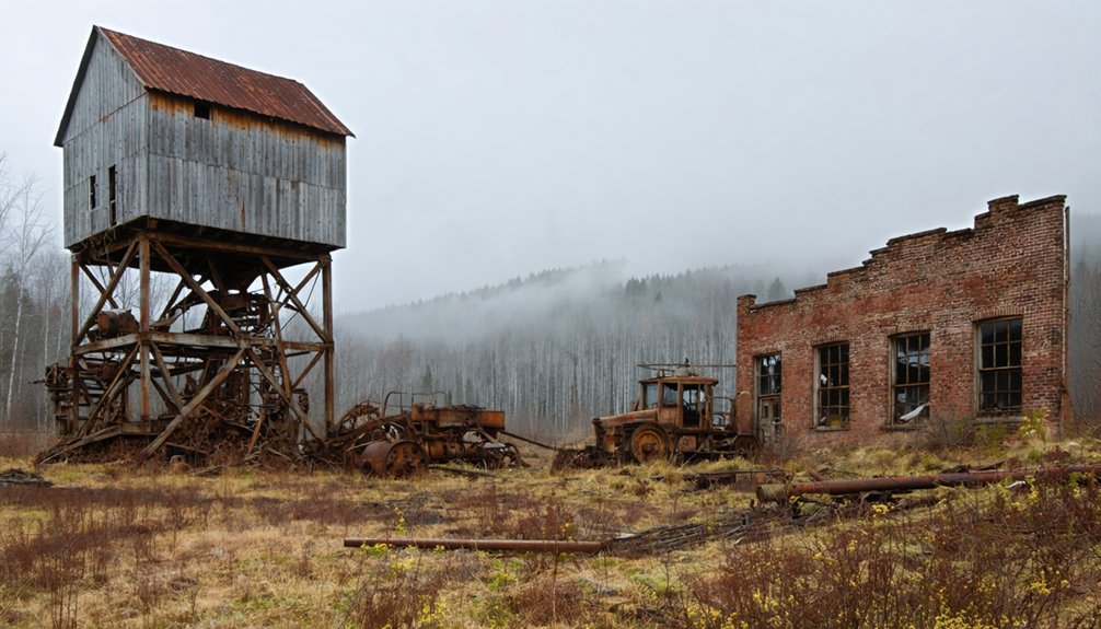
You’ll find Davis’s transformation from farmland to Massachusetts’s largest pyrite mine began in 1882 when New York businessman Herbert Jerome Davis purchased the C.C. Brown farm after geology students discovered iron pyrite outcrops.
By 1890, the Davis Sulphur Ore Company had constructed ten buildings and established a complete mining village that shipped 150 tons of ore daily, extracting pyrite, copper, and other minerals from multiple shafts.
The operation’s collapse came swiftly after Davis’s 1905 death led to deteriorating maintenance practices, culminating in the catastrophic July 1909 cave-in that shut down most operations and forced complete closure by 1912.
Iron Pyrite Mining Boom
Deep beneath Adams Mountain in eastern Rowe, H.J. Davis struck a mineral fortune in 1882 that would trigger a pyrite industry boom across western Massachusetts. His discovery of iron pyrite—containing 47 percent sulfur with remarkably low arsenic levels—arrived precisely when chemical manufacturers desperately needed sulfide for sulfuric acid production during the Second Industrial Revolution.
The Davis Mine’s exceptional ore quality drove regional economic transformation:
- Daily shipments peaked at 150 tons, supplying Boston’s chemical plants
- The main shaft plunged 501 feet deep, yielding 334,552 tons over three decades
- Low arsenic content made Davis pyrite the industry’s preferred source
You’ll find that this mining operation transformed isolated eastern Rowe into a thriving village center, boosting economies throughout Rowe and Charlemont during the 1880s mineral rush.
1911 Mine Collapse Aftermath
After nearly three decades of extracting 334,552 tons of high-grade pyrite, the Davis Mine‘s structural integrity catastrophically failed in 1911. You’ll find the collapse stemmed from systematic pillar robbing and rotted timber supports that A.A. Shippy had supplied. Shafts branched sixty feet in every direction without adequate stability measures.
The abandoned mining infrastructure revealed $400,000 worth of recoverable copper ore in waste piles—a fortune left behind. Groundwater infiltrated the collapsed tunnels, creating a pollution plume that contaminated Davis Mine Creek. The pollution’s environmental impact persists today, with toxic drainage flowing from the workings.
The Four Drowned Towns of Quabbin Reservoir
Four Massachusetts towns vanished beneath the waters of Quabbin Reservoir in one of the state’s most dramatic infrastructure projects. The 1927 Swift River Act condemned Dana, Greenwich, Prescott, and Enfield, forcing 2,500 residents from their homes. By midnight on April 28, 1938, these communities ceased to exist.
The transformation was absolute:
- 14 mills and entire railway systems demolished
- 7,600 bodies exhumed and relocated to Quabbin Memorial Park
- 40,000 acres flooded, leaving 60 hilltops as islands
Authorities razed every structure, cleared vegetation, and dismantled the infrastructure connecting these towns. Despite claims of community preservation, the reservoir prioritized regional water needs over local autonomy.
The subsequent ecological rehabilitation created today’s wilderness area, but the submerged cellar holes and underwater tombstones discovered in 1990s dives remind us what individual liberty was sacrificed.
Enfield: A Hampshire County Town Beneath the Waters

You’ll find Enfield was the wealthiest and most populous of the four Swift River Valley towns condemned by the Massachusetts Legislature in 1927. Before its disincorporation at midnight on April 28, 1938, this Hampshire County community held a Farewell Ball that drew over 2,000 attendees—nearly matching the combined population of all four doomed towns.
The celebration marked the end of a settlement that would soon disappear beneath the waters of Quabbin Reservoir, part of a 25,000-acre flooding zone created to supply Boston’s growing water needs.
Enfield’s Disincorporation and Flooding
When the Massachusetts State Legislature condemned the Swift River Valley in 1927, it set in motion one of the most ambitious public works projects in New England history. Chapter 375 of the Acts of 1926 had already expanded the metropolitan water system to include the Ware and Swift Rivers, and relocation efforts began as residents faced an uncertain future.
Enfield officially ceased to exist at midnight on April 28, 1938, when the Commonwealth dissolved four valley towns. Lost architectural treasures—churches, schools, and homes—vanished beneath rising waters as the Winsor Dam held back the Swift River.
The flooding mechanism transformed the landscape:
- Waters rose gradually over seven years following the August 14, 1939 tunnel sealing
- 2,500 residents displaced from their ancestral homes
- 7,500 bodies exhumed and reinterred in new cemeteries
Life Before the Reservoir
Before the Commonwealth’s surveyors arrived to map its demise, Enfield thrived as a Hampshire County agricultural community where the Swift River powered mills and sustained generations of families. You’d have found industrial enterprises producing palm leaf hats, textiles, and piano legs along the riverbanks, while farms stretched across fertile valley lands. The railroad brought prosperity, connecting local businesses to broader markets.
Homes, churches, schools, and post offices formed the infrastructure of daily life for approximately 2,500 residents across Enfield, Greenwich, Dana, and Prescott. Thirty-four cemeteries held the community’s ancestors.
When Boston’s water demands exceeded supply in the 1890s, the valley’s clean rivers marked it for sacrifice. The 1926 legislation authorized eminent domain, initiating community displacement that would erase these towns forever beneath Quabbin’s waters.
Greenwich: Another Victim of Boston’s Water Needs
Granted in 1737 to descendants of King Philip’s War veterans, the land known as Quabbin became the incorporated town of Greenwich in 1754. You’ll find this farming community once thrived with textile mills and factories before Greenwich’s economic decline made residents vulnerable to state planners.
When Boston’s Metropolitan District Water Supply Commission selected the Swift River Valley for flooding in the 1920s, Greenwich couldn’t resist the taking.
The town’s fate was sealed through these actions:
- Disincorporated April 28, 1938, ending 184 years of self-governance
- All 2,500 valley residents forcibly displaced from their ancestral lands
- Buildings systematically demolished, 7,500 graves relocated
The effects on local economy were catastrophic—landowners received merely $108 per acre as compensation. By 1946, Greenwich lay completely submerged beneath Boston’s reservoir.
Dana: Worcester County’s Submerged Settlement

Since its official incorporation on February 18, 1801, Dana developed from a farming settlement into Worcester County’s progressive manufacturing center. Its rural economy thrived on textile mills powered by Swift River water and enhanced rail access. You’ll find Dana distinguished itself as the Swift River Valley’s first electrified town with motorized fire equipment.
Boston’s water demands sealed Dana’s fate in 1927 when the Legislature authorized the Quabbin Reservoir. Community relocations began after April 28, 1938’s disincorporation. Residents received registered evacuation orders, and landowners were compensated roughly $108 per acre through eminent domain.
Dana Common survives above the reservoir’s flow line. You can hike Old Dana Road to explore granite steps, stone foundations, and preserved walls—testament to lives interrupted for metropolitan necessity.
Long Point: Provincetown’s Abandoned Outpost
While Dana surrendered to metropolitan water needs, Long Point’s abandonment stemmed from economic collapse and geographic isolation. You’ll find this fishing settlement thrived in the 1840s with 200 residents, but fishing industry decline and coastal erosion concerns doomed the community. The four-and-a-half-mile trek over dunes to Provincetown made resupply nearly impossible.
By the late 1850s, residents took extraordinary action:
- Floated 28-30 homes across the harbor to Provincetown’s West End
- Relocated the schoolhouse, later becoming Provincetown’s Post Office
- Left behind only two houses and the lighthouse by 1861
Today you’ll discover automated lighthouse infrastructure, weathered pier pilings, and a WWII memorial marking this Cape Cod National Seashore outpost where economic forces dictated retreat.
Lesser-Known Ghost Towns Across the Commonwealth
Beyond the well-documented losses of Dana and Long Point, Massachusetts harbors dozens of forgotten settlements whose erasure from maps tells equally compelling stories of economic upheaval and environmental vulnerability.
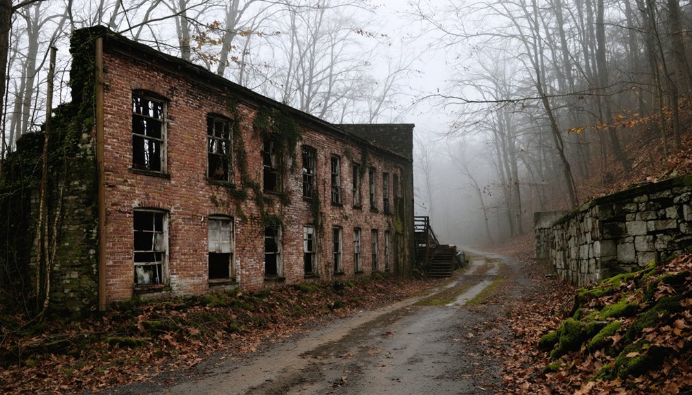
You’ll find Dogtown’s cellar holes hidden beneath old growth forests near Gloucester, abandoned after 1839 when exhausted resources drove its last residents to poorhouses. Catamount in Franklin County succumbed to treacherous terrain, becoming state forest in 1967. Prescott vanished entirely beneath Quabbin Reservoir’s waters in 1928, sacrificed for Boston’s thirst.
The Commonwealth’s maritime ghost towns include Whitewash Village on Cape Cod, where ocean storms and freshwater scarcity forced abandonment. Meanwhile, Haywardville transformed from failed mill town to Middlesex Fells Reservation. These sites resist preservation, their stories surviving only through archaeological fragments and fading records.
Frequently Asked Questions
Can You Visit the Cellar Holes and Ruins in Dogtown Today?
You’ll discover roughly 80 cellar holes hidden among Dogtown’s wild trails—free to explore abandoned dwellings dating to the 1640s. Investigate historical records before venturing out, as dense woods and rocky terrain have swallowed many foundations since 1845.
Are There Any Artifacts Preserved From the Flooded Quabbin Reservoir Towns?
Yes, you’ll find preserved artifacts at the Swift River Valley Historical Society in New Salem. Their collections document reservoir flooding impacts through photographs, farm equipment, wedding dresses, and memorabilia from Dana, Enfield, Greenwich, and Prescott—tagged with original owners’ information.
What Happened to the Residents Displaced by the Quabbin Reservoir Project?
According to historical records, you’ll find that 2,500 displaced residents received minimal Depression-era compensation through eminent domain. Government records show they weren’t prioritized for construction jobs, forcing families to abandon ancestral lands with little state support or relocation assistance.
Are Ghost Towns Legally Accessible or Considered Private Property in Massachusetts?
Want to explore freely? You’ll face legal access restrictions since most ghost towns remain private property or state-controlled lands. Private property regulations require owner permission, while converted public spaces like Quabbin Reservoir have defined entry rules you must follow.
If you’re planning a getaway, consider some road trip tips for Rhode Island to enhance your adventure. The state is small yet packed with charming towns, stunning coastal scenery, and rich history, offering plenty of opportunities for exploration. Make sure to plan your stops wisely to enjoy the best local attractions and hidden gems along the way.
Have Any Bodies or Cemeteries Been Relocated From These Abandoned Towns?
Yes, you’ll find exhumed remains from Massachusetts ghost towns at Quabbin Park Cemetery. The relocation of cemeteries occurred during the 1930s when 7,600 graves from Dana, Enfield, Greenwich, and Prescott were officially moved before flooding.


