You’ll find Vermont’s most compelling ghost towns scattered across the Green Mountains, each telling a different story of collapse. Glastenbury vanished when its logging industry died in the 1880s, while Ricker Basin was literally erased by the catastrophic 1927 flood that killed over 50 residents. West Castleton’s Welsh quarrymen abandoned 43 houses after the slate industry declined, and Copperfield’s 800 miners disappeared when copper prices crashed in 1882. The remnants reveal how quickly prosperity turns to silence when resources run out.
Key Takeaways
- Glastenbury thrived on charcoal and logging post-Civil War but declined by the 1880s after mature trees vanished.
- Copperfield (now Vershire) housed 800+ miners after 1812 copper discovery but collapsed when prices crashed in 1882.
- West Castleton supported 25 slate quarries with 43 buildings by 1853, built by Welsh quarrymen near Lake Bomoseen.
- Ricker Basin’s sawmills and trading posts were destroyed by the catastrophic 1927 flood that killed over 50 residents.
- Ghost towns resulted from textile collapse, mining exhaustion, timber depletion, and shifts from coal to oil energy.
Glastenbury: From Lumber Boom to Silent Forest
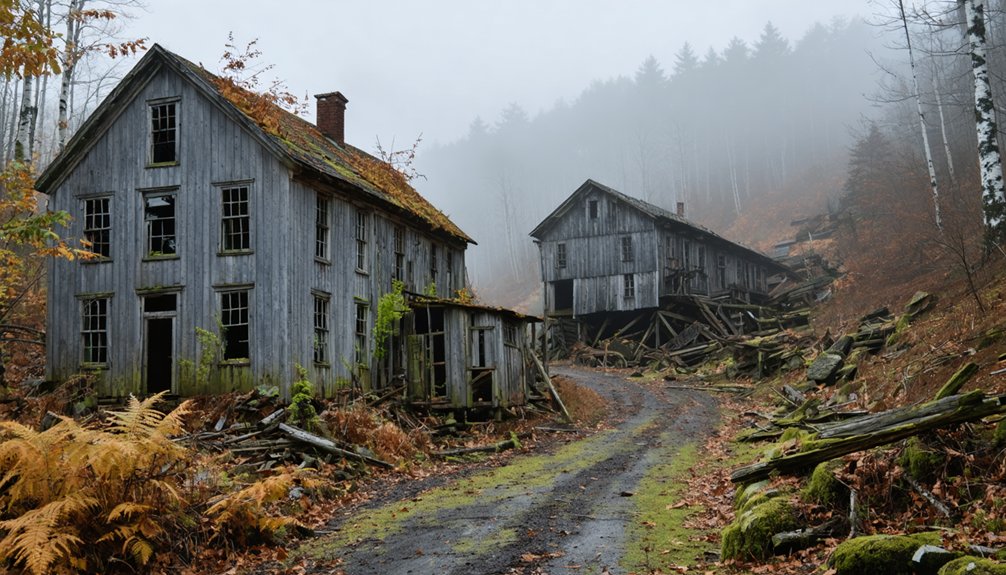
Deep in Vermont’s Green Mountains, the ghost town of Glastenbury tells a story of ambition, industry, and inevitable decline. You’ll find remnants of a community that once thrived with 241 residents in 1880, built around a charcoal making industry that fueled post-Civil War prosperity. The settlement featured everything a frontier town needed: blacksmith shop, sawmill, store, and boarding houses for workers who logged the mountainous terrain.
The logging railroad transformed Glastenbury’s fortunes, hauling timber down for heating and cooking fuel across New England. But by the late 1880s, you’d witness the mature trees vanishing. The railroad ceased operations in 1889, and the town’s fate was sealed. Today, you can explore these ruins via fire roads off Route 9, walking through what’s become silent forest.
West Castleton: Where Welsh Quarrymen Once Worked
While Glastenbury’s loggers felled timber in mountain hollows, Welsh quarrymen were splitting slate from the earth near Lake Bomoseen, building what would become one of Vermont’s most significant industrial settlements. You’ll find West Castleton’s remnants scattered across 600 acres within today’s Bomoseen State Park, where experienced immigrants from northern Wales transformed ledgy farms into profitable quarries after 1852.
These skilled workers brought revolutionary slate quarry technology—underground galleries and efficient waste disposal methods unknown to Vermont farmers. By 1853, they’d built 43 houses, stores, and sawmills supporting 25 quarries. The Welsh cultural legacy persisted through decades of ten-hour days earning less than $2, until exhausted deposits and the 1929 crash silenced the mills.
Cedar Mountain’s slate heap still watches over their vanished town.
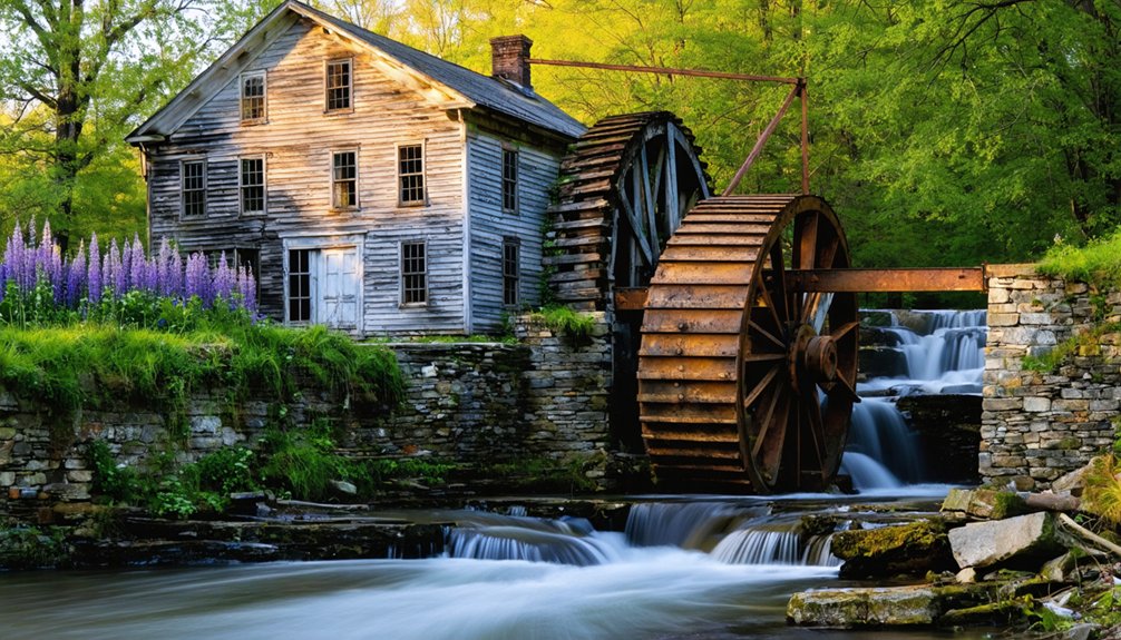
Ricker Basin: Beneath the Waters of Little River
You’ll find Ricker Basin’s story written in three distinct chapters: the railroad’s arrival that transformed Joseph Ricker’s 1816 settlement into a thriving mountain community of fifty families, the catastrophic November 1927 flood that raised the Winooski River thirteen feet and killed over fifty people across the region, and the 1938 completion of Waterbury Dam that forever submerged what remained.
Your exploration of Little River State Park today reveals the physical remnants—cellar holes, cemetery stones, and old sawmill foundations—that rest beneath the reservoir’s surface. These underwater ruins preserve the memory of families who cleared Ricker Mountain’s rocky soil, only to watch their village claimed first by floodwaters, then by a New Deal dam project.
Railroad Prosperity and Growth
- Multiple sawmills processing local timber
- A schoolhouse serving children of new settlers
- Trading posts enabling self-sufficient commerce
- Stone walls and farm roads crisscrossing the landscape
The Waterbury Last Block Company exemplified this prosperity, employing 35 men from 1916-1922 to produce gunstocks and ammunition cases for WWI. They operated with 44 horse teams and one truck, their steam-powered mill humming with possibility for anyone willing to work these mountains.
The Devastating 1927 Flood
On the evening of November 2, 1927, rain began falling across Vermont’s Green Mountains—gentle at first, then relentless. By November 3rd’s afternoon, seven inches had poured down in just six hours. You’d have watched the Winooski River swell thirteen feet above normal, transforming into a destroyer.
The flood impacts were catastrophic: 84 Vermonters dead, including Lieutenant Governor S. Hollister Jackson. Over 50 perished in Ricker Basin alone. The waters claimed 1,285 bridges, swept away mills and factories, and left 9,000 homeless. Houses nearest the river simply vanished, replaced by debris and mud.
This disaster’s environmental legacy changed Vermont forever. By 1935, authorities constructed Waterbury Dam, deliberately submerging what remained of Ricker Basin—a community that had already lost everything to nature’s fury.
Submerged Ruins Today
When water levels in the Waterbury Reservoir drop during drought years, you can glimpse the iron bones of Ricker Basin’s old bridge breaking the surface—a haunting reminder that an entire community lies beneath your feet. The reservoir holds more than water—it preserves former residents’ stories and logging remains from three sawmills that once drove this mountain economy.
Today, you’ll find:
- Almeron Goodell’s farmhouse standing alone, deteriorating from graffiti and neglect
- Stone foundations and cellar holes marking where families built their lives
- Cemetery gravestones weathering among the trees
- Sawmill ruins evidence of timber-driven prosperity
Little River State Park maintains hiking trails to these remnants, letting you walk the old town roads where Joseph Ricker’s 1816 settlement thrived, struggled, and ultimately surrendered to nature’s power.
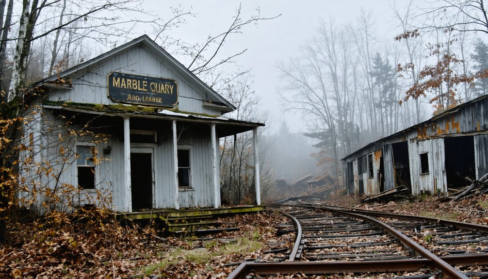
Copperfield (Ely): Rise and Fall of Vermont’s Copper Empire
As prospectors combed Vermont’s hillsides in 1812, they struck copper in the southeastern corner of Vershire—a discovery that would transform this quiet farming community into one of America’s most productive mining operations. By the 1870s, you’d find over 800 Cornish and Irish immigrants working the depths, their mining innovations pushing shafts 1,000 feet down while 24 furnaces blazed above.
The town itself took the name Ely after principal owner Smith Ely, but this prosperity came with strings attached. When copper prices collapsed in 1882, the company couldn’t meet payroll. Workers struck back in July 1883—the “Ely War”—controlling the town until 200 militia members arrived. The community reclaimed its original name, Vershire, that same year, rejecting the legacy of broken promises and labor community conflicts.
Lewiston: The Village Coal Forgot
You’ll find Lewiston’s story etched in the curve of Lewiston Hill Road, where coal once rumbled through rail cars destined for Dartmouth’s furnaces across the river. The 1884 station became the village’s beating heart, transforming this Connecticut River settlement into a crucial transport hub until Dartmouth’s switch to oil pulled the economic rug from beneath residents’ feet.
What the 1950 Wilder Dam couldn’t destroy, the 1967 bulldozers finished—Interstate 91’s access road swallowing Dr. Lewis’s mills, Burton’s tannery, and nearly every structure that had witnessed two centuries of community life.
Railroad Coal Economy Boom
Though Lewiston’s name appeared on maps as early as 1767, the village didn’t truly awaken until 1884, when the railroad station opened its doors along the Connecticut River. You’d have found Thompson’s Coal Yard thriving alongside Ames’ Sawmill, Huggett’s Blacksmith Shop, and Kibling’s General Store, all feeding off Dartmouth College’s voracious appetite for fuel.
Dartmouth’s central heating plant demanded staggering quantities:
- 1,375 tons consumed in year one (1898)
- 3,200 tons annually by 1906
- 18 tons daily during winter’s depths
- 800-ton capacity coal pocket at the heating plant
While industrial pollution blackened the skies, you’d never worry about coal shortages—the railroad guaranteed continuous supply. The 1920 Dartmouth master plan even proposed Station Square, recognizing Lewiston’s economic stranglehold. This wasn’t mere commerce; it was regional domination through bituminous coal.
Energy Transition Impact
The coal dependency era ended without ceremony or alternative. By 1930, every mill had shuttered. You couldn’t sustain a community on memories of bituminous coal and 800-ton storage pockets.
Post-war housing on MacKenna Street tried reversing the slide, but failed. Even a Prohibition-era speakeasy couldn’t inject life into dying streets. When Interstate 91 arrived in 1967, bulldozers merely formalized what Dartmouth’s fuel switch had already accomplished forty years earlier.
Infrastructure Changes Seal Fate
When bulldozers arrived in Lewiston during 1967, they weren’t dismantling a thriving community—they were erasing what remained of a ghost. The infrastructure shift came to finish what economic decline had started decades earlier.
You’d have witnessed the final blow as road-widening crews cleared space for Interstate 91’s feeder roads:
- Station buildings demolished for highway access to Norwich and Hanover
- Rail relocation concentrated commerce at White River Junction
- Historic mill sites buried under asphalt and concrete
- Connecticut River flats transformed into transportation corridors
What the Wilder Dam hadn’t flooded in 1950, the bulldozers claimed seventeen years later. Today you’ll find only scattered remnants—a pottery studio, Lewiston Hill Road’s name, and railroad tracks carrying freight past where a village once stood.
Glastenbury Mountain: The Bennington Triangle Mystery
Nestled among Vermont’s Green Mountains, Glastenbury Mountain became the unlikely epicenter of New England’s most perplexing mystery after researcher Joseph Citro coined the term “Bennington Triangle” in 1992. This 36-square-mile wilderness harbors ghost towns Fayville and Glastenbury, where at least four hikers vanished between 1945 and 1950. The first disappearance involved 75-year-old guide Middie Rivers. Paula Welden‘s case sparked such controversy her family’s criticism led to Vermont State Police’s creation.
Long before modern vanishings, the local Adnaik tribe refused hunting here, warning of indigenous folklore encounters with a “human-eating rock.” Alternative disappearance theories range from energy vortexes to cursed boulders. The Abanaki believed Four Winds met atop this 3,747-foot peak—territory best left unexplored by those who value their freedom.
Economic Forces That Created Vermont’s Ghost Towns
During Vermont’s industrial heyday, entire communities rose and fell with the fortunes of single industries—a pattern that transformed thriving villages into silent ruins within a generation.
You’ll find ghost towns emerged from four primary economic collapses:
- Textile manufacturing devastation – Greenbank’s Hollow lost its 45-worker woolen mill to fire in 1885
- Mining exhaustion – Vershire’s copper operations ceased after producing 60% of U.S. output, leaving EPA Superfund contamination
- Energy shifts – Lewiston’s coal economy vanished when oil replaced traditional fuel sources
- Timber depletion – Glastenbury’s 250 residents abandoned their sawmills after forests disappeared
Labor conditions in resource industries worsened before abandonment, with West Castleton’s slate workers requiring militia intervention during wage disputes. The impact of resource depletion proved irreversible—once extraction ended, communities couldn’t survive.
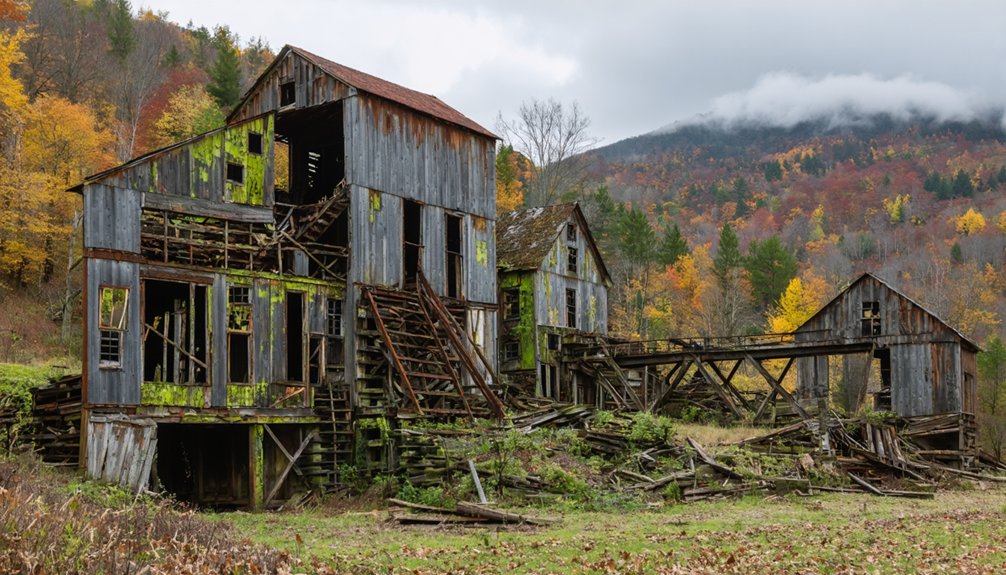
Industrial Ruins You Can Still Visit Today
You’ll find Vermont’s industrial past preserved in three distinct types of ruins, each telling stories of boom and bust.
The Bomoseen Slate History Trail lets you walk among rubble piles and quarry pits where 25 operations once employed entire communities, while Little River State Park reveals foundations of Ricker Basin’s mills and homes partially submerged after dam construction.
At Copperfield, the copper mining site that produced 60% of America’s copper now stands as an EPA Superfund site, its smelter ruins and immigrant worker camps offering sobering evidence of both industrial ambition and environmental cost.
Slate Quarry Remnants Trail
Within the 600 acres of Bomoseen State Park, a self-guided trail winds through one of Vermont’s most tangible connections to its industrial past. You’ll trace the slate quarry origins back to 1843, when operations first carved into Scotch Hill Road. The Irish worker migration of the 1850s brought nearly 250 slaters to transform these hills into America’s largest finishing operation.
As you explore, you’ll encounter:
- Massive rubble piles of discarded slate marking extraction sites
- Water-filled quarry pits with double stacks that once anchored pulley systems
- Crumbling foundations of cramped worker quarters—tiny wood-framed units housing families
- The 1868 slate mill’s walled remains, once the country’s most productive finishing facility
These ruins span Castleton, Fair Haven, Hubbardton, and Benson—a landscape where independence was forged through backbreaking labor.
Submerged Village Foundation Sites
When the Waterbury Dam rose in 1935, it didn’t just tame the Little River—it erased entire chapters of Vermont’s settlement history beneath its waters. You’ll find what remains of Ricker Basin scattered across Little River State Park’s trails—foundations where 50 families once farmed, stone walls marking property lines nobody’s defended in a century.
Dam construction impacts transformed Joseph Ricker’s 1816 settlement into an accidental time capsule. The 1934 flood had already claimed nearly 50 lives before engineers finished drowning the rest. Today, archaeological artifact findings emerge through autumn leaves: glass bottles, farming tools, the stubborn remnants of sawmill operations. One farmhouse still stands—Almeron Goodell’s place, now layered in graffiti. You’re walking through someone’s deliberately forgotten American dream.
Copper Mining Superfund Area
Tucked along Beanville Road in Vershire, the Ely Mine sprawls across 1,880 mountainside acres where Vermont’s copper fever burned hottest from 1813 to 1920. You’ll find industrial ruins still accessible on this privately-owned land, though ongoing superfund remediation continues since EPA’s 2001 designation.
The contamination tells a century-old story through:
- Acid mine drainage flowing into Ely Brook and the Ompompanoosuc River
- Copper, aluminum, iron, and zinc deposits in sediment samples
- Waste piles from Vermont Copper Mining Company’s operations after their 1854 strike
- Water quality monitoring at 98 stream locations tracking downstream impacts
Neighboring communities like West Fairlee live with this legacy as drainage flows toward the Connecticut River. You’re witnessing Vermont’s mining heritage—both its ambition and environmental reckoning.
The Human Cost of Abandonment and Displacement
Behind the romantic notion of Vermont’s ghost towns lies a harsher reality: thousands of families forced from their homes, livelihoods destroyed, and communities erased from the map. You’ll find their stories in crumbling cellar holes and abandoned foundations—immigrants who worked dangerous mines in Ely, loggers who watched Glastenbury’s population vanish, farmers who couldn’t survive rocky soil and brutal winters.
The community deterioration wasn’t just economic. When mills closed and railways bypassed settlements, entire social networks collapsed. Towns like Grafton saw populations plummet from 1,500 to 600. Today’s demographic fragility persists in places like Granby, where 70-80 mostly elderly residents live without basic services. The westward migration and agricultural exodus left behind more than empty buildings—they shattered generational connections and erased ways of life.
Preserving Vermont’s Ghost Town Heritage
As development pressures threaten Vermont’s vulnerable historic settlements, preservation has become a grassroots battle. When a developer targeted Royalton, Sharon, Strafford, and Tunbridge for a 20,000-person community—dwarfing their combined population of under 10,000—volunteer community mobilization raised $300,000 locally. The Vermont Land Trust provided bridge loans to secure threatened parcels as community forests.
Successful preservation strategies include:
- Historic preservation incentives through VHCB’s easement programs protecting 87+ buildings
- National advocacy partnerships that placed threatened towns on watchlists
- Revolving funds that buy, stabilize, and resell abandoned structures
- Direct action, like Santa’s Land’s 2017 restoration after three years vacant
You’ll find Vermont’s most effective defenders aren’t bureaucrats—they’re neighbors refusing to surrender their working landscapes to unchecked development.
Frequently Asked Questions
Are Vermont’s Ghost Towns Safe to Explore Without a Guide?
You shouldn’t explore Vermont’s ghost towns alone—unstable structures create liability concerns, and unmarked private land brings trespassing risks. I’ve seen folks get disoriented on Glastenbury’s trails. Bring experienced companions who know the terrain and respect community boundaries.
Can You Camp Overnight in Areas Where Ghost Towns Existed?
You can’t legally camp at most ghost town sites. Camping regulations restrict proximity to historical structures, and historical preservation concerns protect these areas. State forests nearby allow primitive camping if you’re 100+ feet from ruins and follow designated zone rules.
What Wildlife Now Inhabits Vermont’s Abandoned Settlement Areas?
You’ll find white-tailed deer, bobcats, and migratory bird populations reclaiming Vermont’s abandoned settlements. The presence of small mammals like squirrels thrives among stone cellar holes, while bats inhabit crumbling structures—nature’s triumphant return to freedom.
Do Any Descendants of Former Residents Still Visit These Sites?
You’ll find virtually no descendant visits—Glastenbury’s eight remaining residents tell that story. Ongoing family connections dissolved after disincorporation, though rare individuals conducting personal historical research occasionally explore foundations, seeking ancestral footprints rather than maintaining community traditions.
Which Ghost Town Has the Most Accessible Ruins Year-Round?
You’ll find Ricker Basin most accessible year-round, with abandoned building foundations dotting Little River State Park’s trails. The preserved historical artifacts from mills and homesteads remain reachable through maintained paths, letting you explore freely regardless of season.


