You’re not chasing ruins you can touch—you’re chasing a town buried under nearly 200 feet of water. The original Hochatown was flooded when Broken Bow Lake formed, leaving only a relocated cemetery along Highway 259 as a tangible connection to the past. Base yourself in modern Hochatown, combine nearby ghost towns like Boggy Depot and Eagletown, and download offline maps before heading out. There’s far more to this sunken story than most visitors expect.
Key Takeaways
- The original Hochatown now lies submerged roughly 200 feet beneath Broken Bow Lake after dam construction flooded the valley in the 1960s.
- The relocated cemetery along Highway 259 offers the most tangible connection to old Hochatown, preserving Choctaw settler history above water.
- Base yourself in modern Hochatown, using McCurtain County as a central anchor for exploring multiple ghost towns across two days.
- Day two should include Boggy Depot and Eagletown, both offering preserved cemeteries, timber history, and Native settlement ties.
- Download offline maps, carry cash, and check road conditions before departure, as many historical sites sit in rural, remote areas.
How Broken Bow Lake Swallowed the Original Hochatown
The Mountain Fork River once carved through a valley where Choctaw families had built their lives since the 1830s, and where loggers later filled the air with the sounds of sawmills and trade.
The Mountain Fork River carved not just a valley, but a world — Choctaw homes, sawmill smoke, and a people rooted deep.
That same valley now rests beneath roughly 200 feet of water. When the dam went up and Broken Bow Lake formed, it swallowed the original Hochatown whole. Most buildings were removed or destroyed before the flooding, though the cemetery and church were relocated to higher ground.
What you’re chasing today is a town shaped by Choctaw heritage, a booming lumber economy, and a moonshine legacy that gave it a wild reputation during Prohibition.
The last family didn’t leave until 1966, making this one of Oklahoma’s most compelling flooded ghost-town stories.
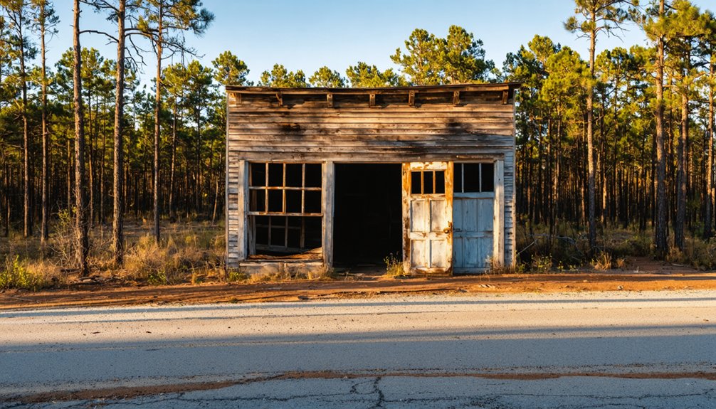
What Remains of the Original Hochatown Today
Although the lake claimed the town itself, a few stubborn remnants connect you to the Hochatown that once was. None of the original structures survived the flooding intact, but the community’s cemetery and church were relocated to higher ground before the waters rose.
You can visit the relocated cemetery along Highway 259, where headstones mark lives rooted in that vanished settlement. These graves represent some of the only surviving historical artifacts tied directly to the original townsite.
Everything else lies roughly 200 feet beneath Broken Bow Lake, preserved only in local memory and written records. That submerged silence carries its own weight.
Standing at those relocated graves, you feel the full story — a community uprooted twice, first by history and then by water.
Where to Stand Above the Sunken Townsite
If you want to feel the weight of Hochatown’s submerged history, head to the shoreline overlooks along Broken Bow Lake, where the water above the original townsite stretches nearly 200 feet deep in places.
You’re fundamentally standing above an entire community — homes, businesses, and streets — sealed beneath the surface since the last family left in 1966.
Park along the lake’s edge, look out at the calm water, and let that depth sink in.
Lakeside Overlook Spots
Several quiet pull-offs and overlooks along the shoreline of Broken Bow Lake let you stand directly above what was once a living, breathing community. From these scenic viewpoints, the water stretches wide and still, hiding roughly 200 feet of history beneath its surface.
You’re looking down at the old townsite where families worked, worshipped, and lived before the dam changed everything.
These spots aren’t crowded tourist platforms. They’re open stretches of shoreline where you control your own pace. Bring a pair of binoculars, take your time, and let the setting sink in.
If you want to combine reflection with lakeside activities, you’ll find fishing access and hiking trails nearby. But the real draw here is that quiet, uncanny feeling of standing above a drowned town.
Depth Of Sunken Ruins
When you peer down from the shoreline into Broken Bow Lake, you’re looking through roughly 200 feet of water at what was once a working Choctaw and timber-era town. That sunken history sits permanently sealed beneath the surface, inaccessible without underwater exploration equipment and permits.
The last family abandoned the original site in 1966, just before rising waters swallowed everything that remained. Standing at the water’s edge near the dam, you’ll feel the weight of that erasure. Streets, foundations, and community landmarks vanished completely when the reservoir filled.
No marker pinpoints the exact location above the submerged ruins, so bring a map of the original townsite if you want to orient yourself. The silence above the water tells the story more powerfully than any sign ever could.
The Relocated Cemetery on Highway 259
Before the rising waters of Broken Bow Lake swallowed the original townsite, workers carefully relocated the community’s cemetery and church to higher ground along Highway 259, preserving the last tangible connection to old Hochatown.
You can find the site today by driving that corridor and watching for the modest grounds that mark where the original community’s dead were reinterred.
Standing there, you’re as close as you’ll ever get to the real Hochatown — the one that once held families, a post office, and a rough Prohibition-era reputation before the flood erased it all.
Cemetery’s Relocation History
As the waters of Broken Bow Lake swallowed the original Hochatown townsite, the community’s cemetery and church couldn’t simply be left to the flood.
Before the dam project displaced everything, locals made sure cemetery preservation happened on their terms — moving the graves and church to higher ground along Highway 259.
This relocation carries deep historical significance, connecting you directly to the people who built this community from scratch after the Trail of Tears.
When you visit, here’s what you’re connecting with:
- Choctaw settlers who survived forced relocation and built something lasting
- Families who logged, farmed, and lived through Prohibition on the frontier
- A community determined to preserve its identity even as the water rose
That relocated ground tells the whole story.
Finding The Highway 259 Site
Locating the relocated cemetery along Highway 259 is straightforward once you know what to look for. You won’t find flashy highway signage pointing you toward history, so staying alert matters.
Watch for local landmarks like small roadside markers or the modest church structure that was moved alongside the cemetery to higher ground. The area sits within McCurtain County, and the surroundings remain relatively rural, keeping the atmosphere authentic.
Pull over when you spot the church, because the cemetery sits nearby. Walk the grounds slowly and read the headstones carefully. These graves represent real families who built Hochatown before the lake swallowed everything they knew.
It’s a quiet, grounding stop that connects you directly to the original community in a way no museum exhibit ever could.
Connecting To Original Hochatown
The relocated cemetery along Highway 259 is your most direct physical connection to the original Hochatown community. Church and cemetery plots were moved to higher ground before Broken Bow Lake swallowed the original townsite, preserving what flooding couldn’t erase.
Walking here puts you inside real Hochatown history.
Look for these details during your visit:
- Choctaw influence: Many graves reflect the Native families who built this community after surviving the Trail of Tears
- Dates spanning generations: Markers trace the arc from 1830s settlement through the logging era
- Quiet authenticity: No tourist infrastructure exists here — just raw, preserved history
This cemetery isn’t a recreation. It’s a surviving fragment of a community that logging, Prohibition, and a reservoir couldn’t fully silence.
Ghost Towns Worth Combining With a Hochatown Trip
Southeast Oklahoma packs enough ghost-town history into one region that combining stops with a Hochatown visit makes real sense.
You can build a full loop through McCurtain County without backtracking much, hitting sites that each tell a different chapter of the same regional story.
Boggy Depot sits to the northwest and gives you a preserved cemetery alongside strong ties to early Native settlement and trade routes.
Boggy Depot offers a preserved cemetery and deep roots in early Native settlement and frontier trade.
It’s a quiet, reflective stop that earns its ghost-town reputation.
Eagletown connects directly to the lumber network that once drove Hochatown’s economy, making it a natural companion stop.
The region’s timber history threads through both communities.
Together, these sites let you move through layers of Native history, frontier industry, and eventual abandonment across a single, worthwhile drive.
How to Plan Your Hochatown Ghost Town Weekend

Pulling those stops together into a single weekend takes a bit of upfront planning, but the route rewards the effort.
Base yourself in modern Hochatown, use McCurtain County as your anchor, and work outward. The historical significance of each stop hits harder when you move between them with intention.
Pack your weekend with:
- Day one: Explore the Broken Bow Lake shoreline, reflect on the submerged original townsite, and visit the relocated cemetery along Highway 259.
- Day two: Drive to Boggy Depot and Eagletown, where timber history and local legends run deep.
- Essentials: Download offline maps, carry cash for rural stops, and check road conditions before heading out.
You’re chasing history that’s partly underwater and partly forgotten — give it the time it deserves.
Frequently Asked Questions
Was Hochatown Originally a Choctaw Settlement After the Trail of Tears?
Yes, you’ll discover that Hochatown began as a Choctaw heritage settlement in the 1830s. It’s deeply rooted in Trail history, as the Choctaw people relocated here from Mississippi following their forced journey on the Trail of Tears.
Did Hochatown Become Known for Moonshine Production During Prohibition?
Yes, you’ll find that Hochatown’s moonshine legacy runs deep! During Prohibition, prohibition effects transformed this remote settlement into a hotbed of illicit distilling, earning it a wild, frontier reputation that still fuels the town’s mysterious, enchanting allure today.
When Did the Original Hochatown Post Office First Open and Close?
Spanning 69 years, Hochatown’s post office history anchors the Hochatown timeline — it first opened in 1894 and closed in 1963. You’ll find this detail paints a vivid picture of the community’s gradual disappearance.
What Industry Shaped Hochatown Before the Lake Flooded the Town?
You’ll discover that the timber industry shaped Hochatown’s soul before economic decline and rising floodwaters silenced it forever. Logging crews and the Choctaw Lumber Company once fueled this rugged, free-spirited community’s heartbeat.
When Did the Last Family Finally Leave the Original Hochatown Site?
Ironically, you’ll find the last family departure didn’t happen until 1966—long after the dam sealed Hochatown’s fate. That historical significance hits hard knowing an entire community quietly vanished beneath 200 feet of water.
References
- https://www.beaversbendcreativeescape.com/se-oklahoma-ghost-towns/
- https://www.youtube.com/watch?v=BH3RSXTWdOo
- https://www.okhistory.org/publications/enc/entry?entry=GH002
- https://en.wikipedia.org/wiki/Hochatown
- https://www.travelok.com/articles/oklahomaghosttowns
- https://mike-boucher.com/wordpress/?page_id=239
- https://www.facebook.com/groups/hochatownpublic/posts/4688024144554479/
- https://www.youtube.com/watch?v=hO4PwXNHEYM
- https://www.ghosttowns.com/states/ok/hochatown.html


