Lauzon, South Dakota sits about 7 miles west of Iron Creek in Custer County, and you’ll want a reliable map or GPS to find it. Summer’s your best bet for exploring its abandoned structures and former residences now used as cow-sheds. Spring and fall offer quieter, cooler conditions if you prefer solitude. Always check road conditions before heading out, wear sturdy footwear, and respect private property boundaries. Keep scrolling to uncover everything this forgotten frontier town has to offer.
Key Takeaways
- Lauzon is located in Custer County, approximately 7 miles west of Iron Creek railroad station, so bring a reliable map or GPS.
- Visit in summer for longer daylight hours or spring and fall for cooler, quieter exploration conditions.
- Explore remaining frontier structures, including abandoned residences repurposed as cow-sheds, but exercise caution around decayed buildings.
- Combine your visit with nearby ghost towns like Scenic and Okaton for a broader historical road trip experience.
- Prepare for unpredictable seasonal road conditions, wear sturdy footwear, and respect all private property boundaries during your visit.
How to Get to Lauzon, South Dakota

Tucked away in Custer County, Lauzon sits roughly 7 miles west of the Iron Creek railroad station, making it one of those destinations you’ll need to plan for rather than stumble upon.
Regional road networks connect you to the area, but don’t expect well-marked signage pointing the way. You’ll want a reliable map or GPS before hitting the access routes leading into this remote corner of South Dakota’s Black Hills region.
The freedom of exploring this ghost town corridor comes with responsibility. Check seasonal road conditions before you go, since rural paths can become impassable after heavy weather.
While you’re out there, you’ll find other local attractions scattered throughout the Black Hills ghost town network, making Lauzon a natural anchor point for a longer regional road trip.
Best Time to Visit Lauzon and Custer County’s Ghost Towns
Once you’ve mapped your route to Lauzon, timing your visit becomes the next critical piece of the puzzle.
Summer offers the best seasonal highlights, with longer daylight hours giving you maximum exploration time among Custer County’s abandoned structures. You’ll photograph deteriorating buildings in natural light and navigate remote roads without worrying about icy conditions.
Summer unlocks Lauzon’s full potential — long daylight hours, clear roads, and perfect natural light for photographing forgotten structures.
Spring and fall deliver quieter visitor experiences, fewer crowds, and cooler temperatures perfect for hiking between ghost town sites.
However, unpaved roads can turn treacherous after heavy rainfall, so check conditions before heading out.
Avoid winter entirely unless you’re an experienced backcountry traveler — snow blocks access roads and shortens your usable daylight dramatically.
Whatever season you choose, arrive early, pack supplies, and respect private property boundaries surrounding these historic structures.
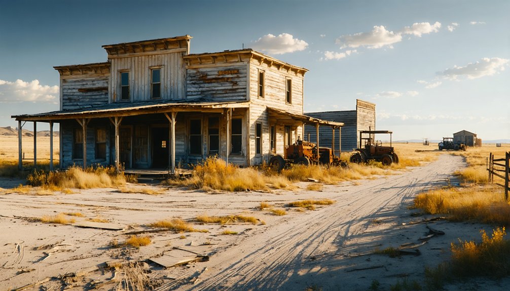
What’s Left to See in Lauzon Today
A handful of structures still stand in Lauzon, giving you a tangible glimpse into this Custer County community’s frontier past.
You’ll find abandoned buildings in various states of decay, including former residences that have been repurposed as cow-sheds — a telling sign of how completely this settlement surrendered to time. The historical significance of these structures lies in their raw authenticity; no restoration softens the reality of economic collapse on the frontier.
Watson Parker’s 1976 field photographs document what existed decades ago, so expect further deterioration today.
Walk carefully around any standing buildings, as weakened foundations and rotting timber create real hazards.
Despite the decay, Lauzon rewards curious explorers with an unfiltered look at South Dakota’s homesteading era, preserved not by intention but simply by isolation.
Ghost Towns Near Lauzon to Pair With Your Visit
While Lauzon itself makes for a rewarding stop, South Dakota’s Black Hills region packs enough ghost town history that you’d be shortchanging yourself by not extending the road trip.
Scenic, founded in 1907, offers abandoned structures that tell a compelling railroad decline story. East Sioux Falls carries its own historical significance, shaped by the 1893 economic panic and a collapsed quartzite industry.
Okaton stands as a textbook example of what happens when railroads abandon a community entirely. Each town adds a distinct chapter to the region’s frontier collapse narrative.
Plotting these stops together lets you cover serious ground while building a richer understanding of why so many South Dakota communities simply faded into the plains.
Private Property, Road Conditions, and Safety Rules for Lauzon
Reaching Lauzon requires more preparation than a typical road trip stop, so you’ll want to treat it with the same respect you’d give any remote and deteriorating site.
Seasonal road conditions can make access unpredictable, particularly during wet or winter months, so check local reports before heading out. Property access is a real consideration here — some structures and surrounding land fall under private ownership, meaning you’ll need to respect posted boundaries and avoid trespassing.
Once you’re on-site, take serious safety precautions around any standing buildings. Decades of neglect have left structures unstable and potentially dangerous to enter. Bring sturdy footwear, stay alert for uneven ground, and keep a safe distance from walls and rooflines.
Respecting both the land and its history makes the experience worthwhile for everyone.
Frequently Asked Questions
What Historical Documentation Exists About Lauzon’s Original Settlement and Community Life?
You’ll find Watson Parker’s 1976 Ghost Town Notebooks are your GPS to Lauzon’s past, capturing settlement patterns, community dynamics, and archival photos that reveal how this frontier store and post office shaped early pioneer life.
How Does Lauzon Compare to Other South Dakota Ghost Towns Historically?
You’ll find Lauzon’s ghost town comparisons reveal fascinating historical significance—it mirrors South Dakota’s broader pattern of abandoned settlements, sharing economic decline stories with East Sioux Falls, Okaton, and Scenic, each reflecting unique frontier-era collapse chapters you can freely explore.
Were Any Preservation Efforts Ever Attempted at Lauzon’s Remaining Structures?
You won’t find documented preservation efforts at Lauzon’s structures. Preservation challenges like private ownership and remote access have limited community involvement, leaving these weathered buildings to tell their own untamed, authentic story of frontier abandonment.
What Economic Factors Originally Caused Lauzon’s Abandonment and Population Decline?
Over 400 South Dakota towns faced abandonment! You’ll find Lauzon’s decline mirrors classic population shifts driven by economic downturns, particularly mining exhaustion, agricultural collapse, and frontier-era market failures that stripped communities of their commercial viability and survival.
Which Researchers Have Formally Studied and Cataloged Lauzon’s Architectural Remains?
Watson Parker’s your go-to researcher — he formally cataloged Lauzon’s architectural significance in his 1976 Ghost Town Notebooks. You’ll find his scholarly research invaluable, as it documents the abandoned structures through detailed field studies and archival photography.
References
- https://en.wikipedia.org/wiki/List_of_ghost_towns_in_South_Dakota
- https://www.youtube.com/watch?v=_0WNYsFLSLA
- https://www.tripadvisor.com/Attraction_Review-g54799-d22999414-Reviews-Scenic_Ghost_Town-Scenic_South_Dakota.html
- https://kxrb.com/south-dakota-ghost-towns-2/
- https://explore.digitalsd.org/digital/collection/WPGhosttown/id/4258
- https://explore.digitalsd.org/digital/collection/WPGhosttown/id/4270/
- https://mad-peak.com/blog-posts-and-info/f/black-hills-ghost-towns-are-real—and-you-can-ride-through-them


